49:
243:
139:
50:
1209:
383:
373:
429:
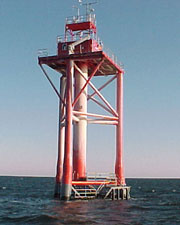
The lower deck was designed for fuel and water storage while the top deck was living quarters for a 6 to 9 man crew. The roof of the platform served as a flight deck for helicopters, the main mode of transport to the station for crew rotations. The tower was automated and the crew was removed from
425:
in about 70 feet (21 m) of water and was supported by four 42-inch (1,100 mm) steel pipes, sunk down about 245 feet (75 m) to bedrock. The light was about 136 feet (41 m) above mean low water and the 10,000,000 candle-power light could be seen for 18 miles (29 km).
453:
and replaced with a new tower. The new tower was built about 1.5 miles (2.4 km) east of the old site, and was approximately 76 feet (23 m) above mean low water, and the 60,000 candle-power light was visible for 18 miles (29 km).
1326:
390:
Various lightships held this station from 1823 until its replacement in 1967. The original was only the fourth lightship designed and commissioned to serve a U.S. coastal port. One of these,
1331:
699:
1336:
461:
struck the new tower. The tower suffered extensive damage, and the light was rendered inoperable. A temporary lighted buoy was set by the Coast Guard on
November 7.
773:
1341:
445:
struck the tower, causing severe damage. Coast Guard
Lighthouse Technicians verified that the light was functioning properly when the tanker hit the tower. The
349:
On July 25, 2008, the Coast Guard announced that
Ambrose Light, which was severely damaged when a tanker struck it on November 3, 2007, would be dismantled.
449:
captain was later found to be at fault. Three years later, in
September 1999 after repairs were deemed insufficient, the old structure was razed by the
585:
788:
722:
783:
712:
1316:
1311:
1240:
647:
1321:
692:
95:
60:
778:
318:
743:
524:
1013:
748:
685:
611:
1148:
853:
662:
305:
1088:
421:
and shipped in sections on barges for assembly on-site. The tower station was about 7.5 miles (12.1 km) off the coast of
1128:
1093:
550:
NTSB Allision of
Bahamas-Registered Tankship M/T Axel Spirit with Ambrose Light Entrance to New York Harbor November 3, 2007
507:
1118:
392:
450:
88:
808:
622:
1270:
1183:
1003:
903:
671:
1233:
1173:
973:
653:
1158:
602:
431:
312:
1249:
948:
848:
813:
406:
1018:
1193:
563:
474:
The tower carried NOAA's
National Data Buoy Center automated weather station ALSN6, which was of interest to
471:
On July 25, 2008, the Coast Guard announced the dismantlement of
Ambrose Light would begin on July 28, 2008.
1285:
1153:
1098:
998:
993:
933:
913:
798:
738:
1198:
1138:
1028:
888:
828:
753:
582:
422:
1226:
1113:
988:
953:
868:
858:
838:
1033:
1178:
873:
1168:
978:
898:
863:
768:
763:
478:, fishermen, and other small craft users. The tower was a staging point for pilot ships, notably the
267:
31:
963:
242:
1280:
1103:
958:
928:
908:
893:
138:
1208:
1265:
1008:
943:
923:
918:
883:
818:
803:
793:
297:
77:
1163:
1143:
1123:
1108:
1083:
1078:
1058:
1048:
1043:
1023:
983:
938:
878:
833:
758:
479:
418:
401:
35:
399:
The original light station was put into operation on August 23, 1967, replacing the obsolete
1275:
1133:
1073:
1063:
435:
1188:
1038:
823:
628:
589:
567:
511:
301:
81:
1290:
968:
615:
549:
438:
until the island and base were transferred to New York State and City for $ 1 in 2003.
414:
272:
634:
352:
The removal work was done by
Costello Dismantling Co. in September 2008. The tugboats
1305:
1068:
1053:
843:
430:
duty on
October 15, 1988. Ambrose light station was controlled electronically by the
17:
59:
410:
540:
NGS says in 1986 the NAD83 position of the light itself was 40.459806N 73.830533W.
382:
64:
Ambrose light station, rebuilt in 1999. This light station was dismantled in 2008.
504:
475:
372:
464:
On
November 3, 2007, the 819-foot (250 m) Bahamas-Registered Tankship M/T
708:
293:
333:
320:
110:
97:
441:
On a clear night in October 1996 the 754-foot (230 m) Greek oil tanker
1218:
677:
596:
187:
468:
struck the tower. This time, Ambrose Light was damaged beyond repair.
364:
assisted. The Coast Guard has replaced the light with flashing buoys.
381:
371:
197:
560:
1222:
681:
30:
This article is about the light tower. For the brigantine, see
614:. United States Coast Guard Historian's Office. Archived from
612:"Historic Light Station Information and Photography: New York"
457:
In January 2001, the 492-foot (150 m) Maltese freighter
1327:
Transportation buildings and structures in Queens, New York
674:- Information, charts, and history of Ambrose light station
505:
Ambrose Light to be deconstructed after 41 years of service
386:
Original Ambrose Light Station, a Texas Tower built in 1967
304:, the primary passage for ships entering and departing the
296:
at the convergence of several major shipping lanes in
525:"Ambrose Light, deemed obsolete, passes into history"
266:
258:
250:
235:
227:
215:
210:
196:
186:
178:
170:
162:
154:
146:
131:
126:
87:
73:
409:, a very strong steel pipe structure based on the
405:, and cost $ 2.4 million. The tower design was a
311:The tower, which was owned and maintained by the
650:- Story about destruction of original structure
396:(built 1908) is now a museum in New York City.
774:Buffalo Harbor North and South entrance Lights
1234:
693:
8:
44:
1241:
1227:
1219:
700:
686:
678:
514:". Press release. Retrieved on 2008-07-25.
262:18 nautical miles (33 km; 21 mi)
241:
137:
58:
43:
1332:Government buildings in Queens, New York
789:Buffalo North Breakwater South End Light
723:List of lighthouses in the United States
27:Former light tower in Lower New York Bay
1337:1967 establishments in New York (state)
784:Buffalo North breakwater East end Light
607:- Ambrose Light is listed as number 720
496:
417:. The structure was prefabricated in
7:
1342:1967 establishments in New York City
231:1999 (Texas Tower), 2008 (New Tower)
779:Buffalo Harbor South Entrance Light
503:U.S. Coast Guard (July 25, 2008). "
1089:South Brother Island Channel Range
182:Tower on red square worded AMBROSE
25:
1129:Strawberry Island Upper Cut Range
1207:
48:
631:- Station ALSN6 - Ambrose Light
306:Port of New York and New Jersey
656:- About lightships, including
1:
1317:Lighthouses completed in 1999
1312:Lighthouses completed in 1967
635:Approaches to New York Harbor
1322:Lighthouses in New York City
451:U.S. Army Corps of Engineers
239:23 m (75 ft)
1271:Buzzards Bay Entrance Light
1014:Oswego Harbor West Pierhead
663:South Street Seaport Museum
625:- Information on lightships
1358:
665:- Current location of the
637:, NOAA Chart 12326 online.
531:. Retrieved on 2009-02-07.
219:1823 (Ambrose Lightship),
29:
1256:
1205:
729:
719:
629:National Data Buoy Center
603:United States Coast Guard
561:Sandy Hook Pilots website
432:United States Coast Guard
313:United States Coast Guard
279:
206:
69:
57:
34:. For the lightship, see
1250:Texas Tower (lighthouse)
1094:South Buffalo North Side
1286:Frying Pan Shoals Light
1119:Stony Point (Henderson)
598:Light List, Volumes 1-7
672:New Jersey Scuba Diver
423:Sandy Hook, New Jersey
387:
379:
1004:Orient Long Beach Bar
413:built for use in the
385:
375:
111:40.45000°N 73.80000°W
18:Ambrose light station
1159:Three Sisters Island
1124:Stony Point (Hudson)
974:North Brother Island
529:Professional Mariner
32:Ambrose Light (ship)
1281:Diamond Shoal Light
592:- Reference article
330: /
221:1967 (Texas Tower)
174:76 feet (23 m)
116:40.45000; -73.80000
107: /
54:
1266:Brenton Reef Light
1019:Plattsburgh Beacon
949:Little Gull Island
849:East Charity Shoal
814:Cold Spring Harbor
588:2006-05-24 at the
566:2006-05-27 at the
510:2008-09-24 at the
388:
380:
298:Lower New York Bay
78:Lower New York Bay
1299:
1298:
1216:
1215:
1194:Whitehall Narrows
1154:Thirty Mile Point
1109:Statue of Liberty
999:Ogdensburg Harbor
994:Old Orchard Shoal
934:Huntington Harbor
809:Charlotte–Genesee
667:Ambrose Lightship
658:Ambrose Lightship
480:Sandy Hook Pilots
419:Norfolk, Virginia
402:Lightship Ambrose
393:Lightship Ambrose
377:Lightship Ambrose
315:, was located at
283:
282:
36:Lightship Ambrose
16:(Redirected from
1349:
1276:Chesapeake Light
1243:
1236:
1229:
1220:
1211:
1199:Whitestone Point
1099:Split Rock Point
1029:Point Aux Roches
904:Frenchman Island
829:Crossover Island
754:Blackwell Island
702:
695:
688:
679:
648:Lighthouse Depot
623:U.S. Coast Guard
619:
606:
583:Lighthouse Depot
570:
558:
552:
547:
541:
538:
532:
521:
515:
501:
436:Governors Island
345:
344:
342:
341:
340:
335:
331:
328:
327:
326:
323:
246:
245:
223:1999 (New Tower)
192:Horn 2 every 15s
142:
141:
122:
121:
119:
118:
117:
112:
108:
105:
104:
103:
100:
62:
55:
53:
52:
21:
1357:
1356:
1352:
1351:
1350:
1348:
1347:
1346:
1302:
1301:
1300:
1295:
1252:
1247:
1217:
1212:
1203:
1114:Stepping Stones
989:Old Field Point
914:Gardiners Point
869:Execution Rocks
859:Elm Tree Beacon
839:Cumberland Head
799:Carleton Island
739:Aunt Phebe Rock
725:
715:
706:
644:
610:
595:
590:Wayback Machine
574:
573:
568:Wayback Machine
559:
555:
548:
544:
539:
535:
523:Yanchmus, Dom.
522:
518:
512:Wayback Machine
502:
498:
488:
370:
338:
336:
334:40.46°N 73.83°W
332:
329:
324:
321:
319:
317:
316:
302:Ambrose Channel
288:, often called
275:White 5 seconds
240:
136:
115:
113:
109:
106:
101:
98:
96:
94:
93:
82:Ambrose Channel
65:
46:
42:
39:
28:
23:
22:
15:
12:
11:
5:
1355:
1353:
1345:
1344:
1339:
1334:
1329:
1324:
1319:
1314:
1304:
1303:
1297:
1296:
1294:
1293:
1291:Savannah Light
1288:
1283:
1278:
1273:
1268:
1263:
1257:
1254:
1253:
1248:
1246:
1245:
1238:
1231:
1223:
1214:
1213:
1206:
1204:
1202:
1201:
1196:
1191:
1186:
1181:
1176:
1171:
1169:Tibbetts Point
1166:
1161:
1156:
1151:
1146:
1141:
1139:Sunken Meadows
1136:
1131:
1126:
1121:
1116:
1111:
1106:
1101:
1096:
1091:
1086:
1081:
1076:
1071:
1066:
1061:
1056:
1051:
1046:
1041:
1036:
1031:
1026:
1021:
1016:
1011:
1006:
1001:
996:
991:
986:
981:
979:North Dumpling
976:
971:
966:
961:
956:
951:
946:
941:
936:
931:
926:
921:
916:
911:
906:
901:
899:Fort Wadsworth
896:
891:
889:Fort Lafayette
886:
881:
876:
871:
866:
864:Esopus Meadows
861:
856:
851:
846:
841:
836:
831:
826:
821:
816:
811:
806:
801:
796:
791:
786:
781:
776:
771:
766:
764:Braddock Point
761:
756:
751:
746:
744:Barber's Point
741:
736:
730:
727:
726:
720:
717:
716:
707:
705:
704:
697:
690:
682:
676:
675:
669:
660:
651:
643:
642:External links
640:
639:
638:
632:
626:
620:
618:on 2017-05-01.
608:
593:
572:
571:
553:
542:
533:
516:
495:
494:
487:
484:
415:Gulf of Mexico
369:
366:
281:
280:
277:
276:
270:
268:Characteristic
264:
263:
260:
256:
255:
254:60,000 candles
252:
248:
247:
237:
233:
232:
229:
225:
224:
217:
213:
212:
208:
207:
204:
203:
200:
194:
193:
190:
184:
183:
180:
176:
175:
172:
168:
167:
164:
160:
159:
156:
152:
151:
148:
144:
143:
133:
129:
128:
124:
123:
91:
85:
84:
75:
71:
70:
67:
66:
63:
40:
26:
24:
14:
13:
10:
9:
6:
4:
3:
2:
1354:
1343:
1340:
1338:
1335:
1333:
1330:
1328:
1325:
1323:
1320:
1318:
1315:
1313:
1310:
1309:
1307:
1292:
1289:
1287:
1284:
1282:
1279:
1277:
1274:
1272:
1269:
1267:
1264:
1262:
1261:Ambrose Light
1259:
1258:
1255:
1251:
1244:
1239:
1237:
1232:
1230:
1225:
1224:
1221:
1210:
1200:
1197:
1195:
1192:
1190:
1187:
1185:
1182:
1180:
1177:
1175:
1172:
1170:
1167:
1165:
1162:
1160:
1157:
1155:
1152:
1150:
1147:
1145:
1142:
1140:
1137:
1135:
1132:
1130:
1127:
1125:
1122:
1120:
1117:
1115:
1112:
1110:
1107:
1105:
1104:Staten Island
1102:
1100:
1097:
1095:
1092:
1090:
1087:
1085:
1082:
1080:
1077:
1075:
1072:
1070:
1067:
1065:
1062:
1060:
1057:
1055:
1052:
1050:
1047:
1045:
1042:
1040:
1037:
1035:
1032:
1030:
1027:
1025:
1022:
1020:
1017:
1015:
1012:
1010:
1007:
1005:
1002:
1000:
997:
995:
992:
990:
987:
985:
982:
980:
977:
975:
972:
970:
967:
965:
962:
960:
959:Montauk Point
957:
955:
952:
950:
947:
945:
942:
940:
937:
935:
932:
930:
929:Hudson-Athens
927:
925:
922:
920:
917:
915:
912:
910:
909:Galloo Island
907:
905:
902:
900:
897:
895:
894:Fort Tompkins
892:
890:
887:
885:
882:
880:
877:
875:
872:
870:
867:
865:
862:
860:
857:
855:
852:
850:
847:
845:
842:
840:
837:
835:
832:
830:
827:
825:
822:
820:
817:
815:
812:
810:
807:
805:
802:
800:
797:
795:
792:
790:
787:
785:
782:
780:
777:
775:
772:
770:
769:Buffalo Light
767:
765:
762:
760:
757:
755:
752:
750:
747:
745:
742:
740:
737:
735:
734:Ambrose Tower
732:
731:
728:
724:
718:
714:
710:
703:
698:
696:
691:
689:
684:
683:
680:
673:
670:
668:
664:
661:
659:
655:
652:
649:
646:
645:
641:
636:
633:
630:
627:
624:
621:
617:
613:
609:
604:
600:
599:
594:
591:
587:
584:
581:
580:
579:
578:
569:
565:
562:
557:
554:
551:
546:
543:
537:
534:
530:
526:
520:
517:
513:
509:
506:
500:
497:
493:
492:
485:
483:
481:
477:
472:
469:
467:
462:
460:
455:
452:
448:
444:
439:
437:
433:
427:
424:
420:
416:
412:
411:oil platforms
408:
404:
403:
397:
395:
394:
384:
378:
374:
367:
365:
363:
359:
355:
350:
347:
343:
339:40.46; -73.83
314:
309:
307:
303:
299:
295:
294:light station
291:
290:Ambrose Tower
287:
286:Ambrose Light
278:
274:
271:
269:
265:
261:
257:
253:
249:
244:
238:
234:
230:
226:
222:
218:
214:
209:
205:
201:
199:
195:
191:
189:
185:
181:
177:
173:
169:
165:
161:
157:
153:
149:
145:
140:
134:
130:
125:
120:
92:
90:
86:
83:
79:
76:
72:
68:
61:
56:
51:
45:Ambrose Light
37:
33:
19:
1260:
1174:Turkey Point
1034:Prince's Bay
1009:Orient Point
944:Latimer Reef
924:Horton Point
919:Horse Island
884:Fort Niagara
819:Coney Island
804:Cedar Island
794:Cape Vincent
733:
666:
657:
654:Night Beacon
616:the original
597:
576:
575:
556:
545:
536:
528:
519:
499:
490:
489:
476:scuba divers
473:
470:
465:
463:
458:
456:
446:
442:
440:
428:
400:
398:
391:
389:
376:
361:
357:
353:
351:
348:
310:
300:, including
289:
285:
284:
236:Focal height
220:
155:Construction
1164:Throgs Neck
1144:Sunken Rock
1084:Sodus Point
1079:Sodus Outer
1059:Sands Point
1049:Romer Shoal
1044:Rock Island
1024:Plum Island
984:Oak Orchard
939:Kings Point
879:Fire Island
854:Eatons Neck
834:Crown Point
759:Bluff Point
709:Lighthouses
466:Axel Spirit
434:station on
407:Texas Tower
362:Miss Yvette
337: /
228:Deactivated
150:Steel piles
132:Constructed
114: /
89:Coordinates
1306:Categories
1184:West Point
1179:Watervliet
1134:Stuyvesant
1074:Shinnecock
1064:Saugerties
954:Little Red
874:Fair Haven
486:References
292:, was the
188:Fog signal
147:Foundation
135:1823
102:73°48′00″W
99:40°27′00″N
41:Lighthouse
1189:West Bank
1149:Tarrytown
1039:Race Rock
824:Coxsackie
749:Barcelona
251:Intensity
216:First lit
163:Automated
969:New Dorp
964:Moriches
713:New York
586:Archived
564:Archived
508:Archived
459:Kouros V
358:Sea Bear
354:Sea Wolf
273:Flashing
202:"N" (−∘)
74:Location
1069:Selkirk
1054:Rondout
844:Dunkirk
577:Sources
447:Aegeo's
368:History
325:73°50′W
322:40°28′N
721:Main:
171:Height
491:Notes
443:Aegeo
259:Range
211:Light
198:Racon
179:Shape
158:Steel
127:Tower
47:
360:and
166:1988
711:of
1308::
601:.
527:.
482:.
356:,
346:.
308:.
80:;
1242:e
1235:t
1228:v
701:e
694:t
687:v
605:.
38:.
20:)
Text is available under the Creative Commons Attribution-ShareAlike License. Additional terms may apply.