136:
240:
934:
22:
247:
272:
413:
959:
969:
348:
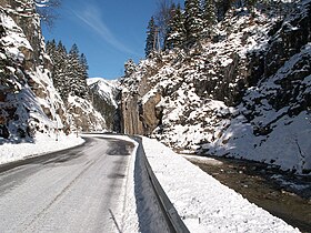
The pass road has a maximum grade of 12 percent. It is mostly fairly straight, although somewhat more winding near the pass. It leaves the German
406:
381:
954:
202:
239:
964:
135:
399:
113:
607:
527:
47:
94:
43:
66:
422:
195:
356:(B 179) at Reutte. From the northeast, it leads through the Graswang Valley along the Linder River, a tributary of the
338:
73:
802:
345:(2161 m.) in the southwest. The first three of these peaks are in Germany, and the Geierköpfe in Austria.
32:
80:
386:
51:
36:
912:
892:
847:
747:
637:
602:
322:
62:
887:
330:
822:
587:
867:
782:
697:
677:
657:
652:
447:
361:
334:
817:
592:
852:
807:
787:
557:
482:
472:
467:
150:
492:
487:
707:
582:
437:
752:
687:
457:
907:
642:
612:
542:
762:
772:
767:
732:
667:
662:
627:
577:
497:
922:
702:
632:
622:
537:
276:
87:
757:
562:
552:
862:
842:
837:
832:
742:
737:
617:
512:
477:
183:
948:
897:
717:
712:
507:
342:
288:
902:
827:
567:
462:
315:
872:
917:
882:
857:
812:
777:
547:
532:
517:
357:
21:
877:
792:
727:
692:
682:
672:
647:
217:
204:
797:
722:
597:
572:
522:
502:
365:
391:
360:(or Ammer) that partly drains away into the chalky soil. The road passes
307:
933:
452:
426:
369:
300:
296:
292:
175:
171:
326:
311:
284:
188:
395:
15:
329:
in northwest Tyrol. The Ammer Saddle is the pass between the
163:
Austrian
Federal Highway B 179 / German Federal Highway B 23
283:, 1,082 m, 3,550 ft) is a high mountain pass in the
194:
182:
167:
159:
149:
128:
407:
8:
50:. Unsourced material may be challenged and
414:
400:
392:
310:region of southern Bavaria. It leads from
125:
341:(2185 m.) in the southeast, and the
114:Learn how and when to remove this message
960:Mountain passes of Tyrol (federal state)
368:. On the Austrian side, it passes the
382:List of highest paved roads in Europe
333:(2082 m.) on the northwest, the
7:
246:
48:adding citations to reliable sources
352:23 at Ettal and joins the Austrian
14:
337:(1926 m.) on the north, the
970:Austria–Germany border crossings
932:
245:
238:
134:
20:
1:
955:Mountain passes of the Alps
306:The pass is located in the
986:
965:Mountain passes of Bavaria
929:
433:
233:
133:
387:List of mountain passes
848:Kleiner Semmering
323:Garmisch-Partenkirchen
287:on the border between
280:
331:Ammergauer Hochplatte
218:47.53778°N 10.88972°E
748:Pielachtaler Gscheid
658:Klostertaler Gscheid
362:Ludwig II of Bavaria
44:improve this article
214: /
155:1,082 m (3,550 ft).
223:47.53778; 10.88972
942:
941:
803:Radstädter Tauern
638:Kernhofer Gscheid
264:
263:
124:
123:
116:
98:
977:
937:
936:
888:Triebener Tauern
823:Schiestelscharte
416:
409:
402:
393:
275:
249:
248:
242:
229:
228:
226:
225:
224:
219:
215:
212:
211:
210:
207:
138:
126:
119:
112:
108:
105:
99:
97:
56:
24:
16:
985:
984:
980:
979:
978:
976:
975:
974:
945:
944:
943:
938:
931:
927:
868:Styrian Seeberg
783:Preiner Gscheid
429:
420:
378:
354:Fernpass Straße
335:Scheinbergspitz
271:
260:
259:
258:
257:
256:
255:
254:
250:
222:
220:
216:
213:
208:
205:
203:
201:
200:
145:
120:
109:
103:
100:
57:
55:
41:
25:
12:
11:
5:
983:
981:
973:
972:
967:
962:
957:
947:
946:
940:
939:
930:
928:
926:
925:
920:
915:
913:Windische Höhe
910:
905:
900:
895:
890:
885:
880:
875:
870:
865:
860:
855:
850:
845:
840:
835:
830:
825:
820:
815:
810:
805:
800:
795:
790:
785:
780:
775:
770:
765:
760:
755:
750:
745:
740:
735:
730:
725:
720:
715:
710:
705:
700:
695:
690:
685:
680:
675:
670:
665:
660:
655:
650:
645:
640:
635:
630:
625:
620:
615:
610:
605:
600:
595:
590:
585:
580:
575:
570:
565:
560:
555:
550:
545:
540:
535:
530:
525:
520:
515:
510:
505:
500:
495:
490:
485:
480:
475:
470:
465:
460:
455:
450:
445:
440:
434:
431:
430:
421:
419:
418:
411:
404:
396:
390:
389:
384:
377:
374:
262:
261:
252:
251:
244:
243:
237:
236:
235:
234:
231:
230:
198:
192:
191:
186:
180:
179:
169:
165:
164:
161:
157:
156:
153:
147:
146:
140:Ammer Saddle (
139:
131:
130:
122:
121:
63:"Ammer Saddle"
28:
26:
19:
13:
10:
9:
6:
4:
3:
2:
982:
971:
968:
966:
963:
961:
958:
956:
953:
952:
950:
935:
924:
921:
919:
916:
914:
911:
909:
906:
904:
901:
899:
896:
894:
891:
889:
886:
884:
881:
879:
876:
874:
871:
869:
866:
864:
861:
859:
856:
854:
851:
849:
846:
844:
841:
839:
836:
834:
831:
829:
826:
824:
821:
819:
816:
814:
811:
809:
806:
804:
801:
799:
796:
794:
791:
789:
786:
784:
781:
779:
776:
774:
771:
769:
766:
764:
761:
759:
756:
754:
751:
749:
746:
744:
741:
739:
736:
734:
731:
729:
726:
724:
721:
719:
716:
714:
711:
709:
706:
704:
701:
699:
696:
694:
691:
689:
686:
684:
681:
679:
676:
674:
671:
669:
666:
664:
661:
659:
656:
654:
651:
649:
646:
644:
641:
639:
636:
634:
631:
629:
626:
624:
621:
619:
616:
614:
611:
609:
606:
604:
601:
599:
596:
594:
591:
589:
586:
584:
581:
579:
576:
574:
571:
569:
566:
564:
561:
559:
556:
554:
551:
549:
546:
544:
541:
539:
536:
534:
531:
529:
526:
524:
521:
519:
516:
514:
511:
509:
506:
504:
501:
499:
496:
494:
491:
489:
486:
484:
481:
479:
476:
474:
473:Buchener Höhe
471:
469:
466:
464:
461:
459:
456:
454:
451:
449:
446:
444:
441:
439:
436:
435:
432:
428:
424:
423:Alpine passes
417:
412:
410:
405:
403:
398:
397:
394:
388:
385:
383:
380:
379:
375:
373:
371:
367:
364:'s castle of
363:
359:
355:
351:
346:
344:
340:
336:
332:
328:
324:
321:
317:
313:
309:
304:
302:
298:
294:
290:
286:
282:
278:
274:
269:
241:
232:
227:
199:
197:
193:
190:
187:
185:
181:
177:
173:
170:
166:
162:
158:
154:
152:
148:
143:
137:
132:
127:
118:
115:
107:
96:
93:
89:
86:
82:
79:
75:
72:
68:
65: –
64:
60:
59:Find sources:
53:
49:
45:
39:
38:
34:
29:This article
27:
23:
18:
17:
653:Klippitztörl
603:Hochtannberg
568:Hahntennjoch
543:Gerichtsberg
528:Fuscher Törl
488:Eisentalhöhe
442:
353:
350:Bundesstraße
349:
347:
319:
316:Oberammergau
305:
268:Ammer Saddle
267:
265:
253:Ammer Saddle
160:Traversed by
141:
129:Ammer Saddle
110:
101:
91:
84:
77:
70:
58:
42:Please help
30:
883:Timmelsjoch
708:Norberthöhe
339:Kreuzspitze
281:Ammersattel
221: /
196:Coordinates
142:Ammersattel
949:Categories
923:Zellerrain
753:Pillerhöhe
703:Niederalpl
648:Klammljoch
643:Kerschbaum
633:Katschberg
623:Josefsberg
613:Holzleiten
458:Bielerhöhe
343:Geierköpfe
209:10°53′23″E
206:47°32′16″N
74:newspapers
908:Weinebene
843:Semmering
733:Paulitsch
663:Kreuzberg
628:Kartitsch
618:Iselsberg
598:Hochrindl
588:Hirschegg
523:Furkajoch
513:Flattnitz
498:Feistritz
366:Linderhof
320:Landkreis
273:‹See Tfd›
151:Elevation
104:June 2019
31:does not
898:Ursprung
808:Rechberg
778:Präbichl
773:Pötschen
768:Pölshals
718:Oberjoch
698:Neumarkt
678:Lienbach
558:Griffner
538:Gailberg
493:Faschina
448:Annaberg
376:See also
318:(in the
308:Ammergau
168:Location
903:Wechsel
893:Turrach
863:Staller
838:Seefeld
833:Seeberg
828:Schober
818:Schaida
763:Pogusch
758:Plöcken
743:Pfaffen
738:Perchau
693:Naßfeld
608:Hochtor
593:Hochegg
563:Gschütt
553:Grießen
478:Dienten
463:Brenner
453:Arlberg
427:Austria
370:Plansee
301:Germany
297:Bavaria
293:Austria
176:Germany
172:Austria
88:scholar
52:removed
37:sources
918:Wurzen
858:Soboth
853:Silzer
788:Pretal
713:Obdach
668:Kühtai
583:Hengst
578:Hebalm
548:Gerlos
533:Gaberl
518:Flexen
508:Filzen
483:Eibegg
468:Buchau
327:Reutte
277:German
178:border
90:
83:
76:
69:
61:
878:Thurn
793:Pyhrn
688:Losen
683:Loibl
443:Ammer
358:Amper
325:) to
314:near
312:Ettal
289:Tyrol
184:Range
95:JSTOR
81:books
873:Sölk
813:Rohr
798:Radl
728:Pack
673:Lahn
573:Hals
503:Fern
438:Alpl
295:and
285:Alps
266:The
189:Alps
67:news
35:any
33:cite
723:Och
425:in
46:by
951::
372:.
303:.
299:,
291:,
279::
415:e
408:t
401:v
270:(
174:–
144:)
117:)
111:(
106:)
102:(
92:·
85:·
78:·
71:·
54:.
40:.
Text is available under the Creative Commons Attribution-ShareAlike License. Additional terms may apply.