159:
38:
45:
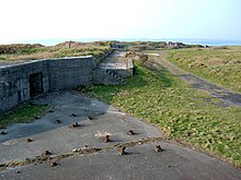
174:. The hollows in the banks around it were used to house machine guns in the Second World War and there was a searchlight battery here. Inland from East Picket bay are the remnants of the E-Pens used to house fighter aircraft if they were needed. In a field close to the
190:
that was used as housing for a searchlight. On a rocky patch of ground at west pill is a brick mine watcher hut. This was used specifically to watch out for the enemy who may be laying mines in
Milford Haven.
359:
61:
249:
landed at Angle airfield after receiving hull damage during a rescue. It returned to the RAF and became home to the
Coastal command unit who tested weapons that could be used against German
329:
78:
253:. After the war was over the buildings were no longer used and many were removed in the 1980s; however, some still stand in remote locations.
218:
148:
25:
349:
37:
354:
266:. The coastline around Angle was severely damaged. The effect of the oil spill lasted several years and cost £60 million.
230:
71:
334:
182:
lifeboat house there are visible remains of an anti-aircraft post. This site was later changed and used to house a
158:
295:
296:"Site Of Special Scientific Interest Citation: Pembrokeshire - Arfordir Penrhyn Angle/Angle Peninsula Coast"
183:
222:
136:
226:
178:
memorial there are the remains of an anti-aircraft post. On a section of the coastal path just past the
275:
312:
234:
118:
246:
210:
214:
152:
343:
238:
206:
140:
198:
167:
258:
175:
242:
93:
80:
263:
202:
194:
171:
262:
grounded at the
Milford Haven Waterway entrance, spilling 72,000 tonnes of
250:
157:
144:
179:
187:
360:
Sites of
Special Scientific Interest in Pembrokeshire
117:
109:
70:
60:
217:, housed several squadrons during the war such as
151:. There is a wide range of wildlife and a former
237:. In 1943 operational control passed on to the
209:. The airfield, which began as a station for
170:defences and the site of the former air base
44:
8:
186:. At the north hill, there are remains of a
135:on the southern side of the entrance to the
19:
16:Site of Special Scientific Interest in Wales
18:
287:
301:. Countryside Council for Wales. 2003.
7:
256:On 15 February 1996, the oil tanker
219:No. 312 (Czechoslovak) Squadron RAF
149:Site of Special Scientific Interest
26:Site of Special Scientific Interest
14:
43:
36:
313:"BBC Wales On Air:Sea Empress"
123:1 January 1953/16 October 2003
113:133.5 hectares (1.335 km)
1:
184:40 mm Rolls-Royce cannon
335:BBC Wales South West - Angle
162:Remains of gun emplacements
376:
201:. It opened in 1941 after
166:The peninsula is rich in
31:
24:
350:Beaches of Pembrokeshire
197:was an airfield during
355:Coast of Pembrokeshire
247:Sunderland flying boat
223:412 Transport Squadron
163:
137:Milford Haven Waterway
245:. During this time a
227:Supermarine Spitfires
161:
133:Angle Peninsula Coast
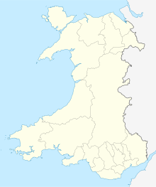
52:Location within Wales
20:Angle Peninsula Coast
276:Angle, Pembrokeshire
94:51.68022°N 5.09766°W
231:Westland Whirlwinds
90: /
21:
225:. Planes included
164:
99:51.68022; -5.09766
235:Hawker Hurricanes
221:and the Canadian
127:
126:
367:
317:
316:
309:
303:
302:
300:
292:
205:attacks against
168:Second World War
105:
104:
102:
101:
100:
95:
91:
88:
87:
86:
83:
47:
46:
40:
22:
375:
374:
370:
369:
368:
366:
365:
364:
340:
339:
326:
321:
320:
311:
310:
306:
298:
294:
293:
289:
284:
272:
215:Fighter Command
153:Royal Air Force
98:
96:
92:
89:
84:
81:
79:
77:
76:
56:
55:
54:
53:
50:
49:
48:
17:
12:
11:
5:
373:
371:
363:
362:
357:
352:
342:
341:
338:
337:
332:
325:
324:External links
322:
319:
318:
304:
286:
285:
283:
280:
279:
278:
271:
268:
125:
124:
121:
115:
114:
111:
107:
106:
74:
68:
67:
64:
58:
57:
51:
42:
41:
35:
34:
33:
32:
29:
28:
15:
13:
10:
9:
6:
4:
3:
2:
372:
361:
358:
356:
353:
351:
348:
347:
345:
336:
333:
331:
328:
327:
323:
314:
308:
305:
297:
291:
288:
281:
277:
274:
273:
269:
267:
265:
261:
260:
254:
252:
248:
244:
240:
239:Fleet Air Arm
236:
232:
228:
224:
220:
216:
212:
208:
207:Pembroke Dock
204:
200:
196:
192:
189:
185:
181:
177:
173:
169:
160:
156:
154:
150:
146:
142:
141:Pembrokeshire
138:
134:
129:
122:
120:
116:
112:
108:
103:
75:
73:
69:
66:Pembrokeshire
65:
63:
59:
39:
30:
27:
23:
307:
290:
257:
255:
211:No. 10 Group
199:World War II
193:
165:
132:
130:
128:
119:Notification
259:Sea Empress
176:World War I
97: /
72:Coordinates
344:Categories
282:References
243:Royal Navy
82:51°40′49″N
330:Angle Map
264:crude oil
203:Luftwaffe
195:RAF Angle
188:Laing hut
172:RAF Angle
85:5°05′52″W
270:See also
155:station.
62:Location
251:U-boats
241:of the
147:, is a
299:(PDF)
145:Wales
233:and
180:RNLI
131:The
110:Area
139:in
346::
229:,
213:,
143:,
315:.
Text is available under the Creative Commons Attribution-ShareAlike License. Additional terms may apply.