490:
84:
466:
478:
117:
45:
64:
454:
124:
91:
430:
The oldest church dates from the 14th century. It later became a ruin and was partially demolished. The
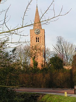
Rombouts tower has been restored in 1954. The current Dutch Reformed church dates from the 16th century, and has been enlarged in 1852 and around 1950.
360:
Op-Andel was first mentioned in 850 as Analo, and means "higher open forest". Neer-Andel was mentioned in 1382 as "dat derp tot
Uutandele", and means the lower or downstream part. The villages developed on the banks of the
882:
706:
901:
83:
911:
906:
489:
465:
699:
296:
152:
368:
399:
308:
44:
692:
716:
636:
116:
477:
288:
434:
Andel was home to 738 people in 1840. Until 1973, Andel was an independent municipality when it was merged into
184:
453:
810:
325:
321:
720:
439:
341:
267:
209:
427:). Later both merged into a single urban area. Roman pottery has been discovered from the 2nd century.
63:
800:
790:
277:
626:
596:
861:
684:
871:
765:
570:
825:
795:
632:
835:
519:
362:
895:
199:
856:
830:
805:
345:
189:
866:
851:
744:
435:
414:
401:
383:
370:
365:. The village used to consist of two parts: an upstream part named Op-Andel (
167:
154:
815:
770:
739:
349:
258:
17:
785:
820:
734:
337:
780:
775:
284:
263:
662:
544:
688:
103:
Location in the province of North
Brabant in the Netherlands
883:
List of cities, towns and villages in North
Brabant
844:
753:
727:
317:
307:
295:
274:
257:
249:
241:
236:
228:
220:
215:
205:
195:
183:
28:
700:
348:. It is located about 7 km southeast of
8:
625:Chris Kolman & Ronald Stenvert (1997).
396:), and a downstream part named Neer-Andel (
707:
693:
685:
620:
618:
25:
657:
655:
506:
449:
294:
256:
235:
227:
214:
182:
147:
75:
57:
41:
902:Former municipalities of North Brabant
514:
512:
510:
316:
306:
273:
248:
240:
219:
204:
194:
23:Village in North Brabant, Netherlands
7:
520:"Kerncijfers wijken en buurten 2021"
224:6.23 km (2.41 sq mi)
912:Geography of Altena, North Brabant
597:"Neer-Andel - (geografische naam)"
16:For the village in Groningen, see
14:
907:Populated places in North Brabant
571:"Op-Andel - (geografische naam)"
488:
476:
464:
452:
122:
115:
89:
82:
62:
43:
551:(in Dutch). Het Waterschapshuis
549:Actueel Hoogtebestand Nederland
631:(in Dutch). Zwolle: Waanders.
1:
459:1865 map of the municipality.
438:. In 2019, it became part of
123:
90:
524:Central Bureau of Statistics
928:
471:Lock in the Afgedamde Maas
15:
880:
545:"Postcodetool for 4281JA"
253:410/km (1,100/sq mi)
148:
106:Show map of North Brabant
76:
58:
53:(Rombouts tower) in Andel
42:
35:
715:Populated places in the
232:1.4 m (4.6 ft)
340:in the municipality of
139:Show map of Netherlands
342:Altena, North Brabant
276: • Summer (
415:51.78417°N 5.05417°E
384:51.78250°N 5.06111°E
250: • Density
168:51.78389°N 5.05389°E
411: /
380: /
164: /
136:Andel (Netherlands)
242: • Total
221: • Total
889:
888:
420:51.78417; 5.05417
389:51.78250; 5.06111
331:
330:
173:51.78389; 5.05389
919:
709:
702:
695:
686:
679:
678:
676:
674:
659:
650:
649:
647:
645:
622:
613:
612:
610:
608:
593:
587:
586:
584:
582:
567:
561:
560:
558:
556:
541:
535:
534:
532:
530:
516:
492:
480:
468:
456:
426:
425:
423:
422:
421:
416:
412:
409:
408:
407:
404:
395:
394:
392:
391:
390:
385:
381:
378:
377:
376:
373:
281:
179:
178:
176:
175:
174:
169:
165:
162:
161:
160:
157:
140:
126:
125:
119:
107:
93:
92:
86:
66:
47:
26:
927:
926:
922:
921:
920:
918:
917:
916:
892:
891:
890:
885:
876:
840:
836:Wijk en Aalburg
766:Babyloniënbroek
749:
723:
713:
683:
682:
672:
670:
661:
660:
653:
643:
641:
639:
624:
623:
616:
606:
604:
595:
594:
590:
580:
578:
569:
568:
564:
554:
552:
543:
542:
538:
528:
526:
518:
517:
508:
503:
496:
493:
484:
481:
472:
469:
460:
457:
448:
419:
417:
413:
410:
405:
402:
400:
398:
397:
388:
386:
382:
379:
374:
371:
369:
367:
366:
358:
303:
275:
172:
170:
166:
163:
158:
155:
153:
151:
150:
144:
143:
142:
141:
138:
137:
134:
133:
132:
131:
127:
110:
109:
108:
105:
104:
101:
100:
99:
98:
94:
72:
71:
70:
69:
54:
38:
31:
24:
21:
12:
11:
5:
925:
923:
915:
914:
909:
904:
894:
893:
887:
886:
881:
878:
877:
875:
874:
869:
864:
859:
854:
848:
846:
842:
841:
839:
838:
833:
828:
823:
818:
813:
808:
803:
798:
793:
788:
783:
778:
773:
768:
763:
757:
755:
751:
750:
748:
747:
742:
737:
731:
729:
725:
724:
714:
712:
711:
704:
697:
689:
681:
680:
651:
637:
614:
601:Etymologiebank
588:
575:Etymologiebank
562:
536:
505:
504:
502:
499:
498:
497:
495:House in Andel
494:
487:
485:
483:House in Andel
482:
475:
473:
470:
463:
461:
458:
451:
447:
444:
363:Afgedamde Maas
357:
354:
329:
328:
319:
315:
314:
311:
305:
304:
301:
299:
293:
292:
282:
272:
271:
261:
255:
254:
251:
247:
246:
243:
239:
238:
234:
233:
230:
226:
225:
222:
218:
217:
213:
212:
207:
203:
202:
197:
193:
192:
187:
181:
180:
146:
145:
135:
129:
128:
121:
120:
114:
113:
112:
111:
102:
96:
95:
88:
87:
81:
80:
79:
78:
77:
74:
73:
67:
61:
60:
59:
56:
55:
48:
40:
39:
36:
33:
32:
29:
22:
13:
10:
9:
6:
4:
3:
2:
924:
913:
910:
908:
905:
903:
900:
899:
897:
884:
879:
873:
870:
868:
865:
863:
860:
858:
855:
853:
850:
849:
847:
843:
837:
834:
832:
829:
827:
824:
822:
819:
817:
814:
812:
809:
807:
804:
802:
799:
797:
794:
792:
789:
787:
784:
782:
779:
777:
774:
772:
769:
767:
764:
762:
759:
758:
756:
752:
746:
743:
741:
738:
736:
733:
732:
730:
726:
722:
718:
710:
705:
703:
698:
696:
691:
690:
687:
668:
664:
658:
656:
652:
640:
638:90 400 9945 6
634:
630:
629:
621:
619:
615:
602:
598:
592:
589:
576:
572:
566:
563:
550:
546:
540:
537:
525:
521:
515:
513:
511:
507:
500:
491:
486:
479:
474:
467:
462:
455:
450:
445:
443:
441:
437:
432:
428:
424:
393:
364:
355:
353:
351:
347:
343:
339:
335:
327:
323:
320:
312:
310:
300:
298:
290:
286:
283:
279:
269:
265:
262:
260:
252:
244:
231:
223:
211:
208:
201:
200:North Brabant
198:
191:
188:
186:
177:
149:Coordinates:
118:
85:
65:
52:
51:Romboutstoren
49:14th century
46:
34:
27:
19:
857:Kievitswaard
760:
717:municipality
671:. Retrieved
667:Plaatsengids
666:
642:. Retrieved
627:
605:. Retrieved
600:
591:
579:. Retrieved
574:
565:
553:. Retrieved
548:
539:
527:. Retrieved
523:
433:
429:
359:
333:
332:
309:Dialing code
206:Municipality
68:Coat of arms
50:
831:Waardhuizen
806:Nieuwendijk
418: /
387: /
346:Netherlands
318:Major roads
297:Postal code
190:Netherlands
171: /
896:Categories
867:Vierbannen
852:Emmikhoven
745:Woudrichem
669:(in Dutch)
603:(in Dutch)
577:(in Dutch)
501:References
436:Woudrichem
372:51°46′57″N
237:Population
816:Sleeuwijk
771:Drongelen
740:Werkendam
403:51°47′3″N
350:Gorinchem
344:, in the
259:Time zone
229:Elevation
156:51°47′2″N
18:Den Andel
811:Rijswijk
786:Genderen
754:Villages
673:14 April
644:14 April
607:14 April
581:14 April
555:14 April
529:14 April
406:5°3′15″E
375:5°3′40″E
196:Province
159:5°3′14″E
872:'t Zand
845:Hamlets
821:Uitwijk
801:Meeuwen
791:Giessen
735:Almkerk
663:"Andel"
446:Gallery
356:History
338:village
185:Country
37:Village
781:Eethen
776:Dussen
721:Altena
635:
440:Altena
210:Altena
862:Kille
761:Andel
728:Towns
628:Andel
336:is a
334:Andel
285:UTC+2
264:UTC+1
245:2,530
130:Andel
97:Andel
30:Andel
826:Veen
796:Hank
675:2022
646:2022
633:ISBN
609:2022
583:2022
557:2022
531:2022
326:N322
322:N267
313:0183
302:4281
289:CEST
216:Area
719:of
278:DST
268:CET
898::
665:.
654:^
617:^
599:.
573:.
547:.
522:.
509:^
442:.
352:.
324:,
708:e
701:t
694:v
677:.
648:.
611:.
585:.
559:.
533:.
291:)
287:(
280:)
270:)
266:(
20:.
Text is available under the Creative Commons Attribution-ShareAlike License. Additional terms may apply.