57:
708:
509:
42:
321:
597:
451:
417:
The 2010 census population of the
Andersonville CDP was 472, including 366 people over 18 and 106 children under 18 years old. The population was 98.5% white, 0.4% Native American or Alaskan native, 0.2% Asian, 0.2% Native Hawaiian and Other Pacific Islander, 0.2% some other race, and 0.4% two or
356:
for boarding students, who comprised the majority of the high school enrollment. The
Anderson County School Board assumed ownership and responsibility for the school in 1923. In 1938 Andersonville's high school students were moved to the new Norris High School in
361:
and
Andersonville's school became an elementary school again. The old two-story school building was torn down in 1958 and replaced by a new single-story building on the same site that reopened three years later as Andersonville Elementary School.
56:
915:
580:
629:
487:
925:
920:
348:
purchases by local citizens. It was renamed
Andersonville Institute in 1898, after the Clinton Baptist Association purchased the school building and added
622:
78:
770:
248:
795:
790:
780:
775:
615:
258:
601:
427:
607:
132:
821:
560:
426:
The climate in this area is characterized by hot, humid summers and generally mild to cool winters. According to the
41:
639:
329:
278:
137:
62:
726:
431:
396:
885:
805:
289:
274:
110:
46:
475:
862:
737:
344:, which was started in 1830. It was replaced in 1873 by Big Valley Academy, a grade school financed through
309:
297:
282:
32:
810:
837:
750:
892:
696:
690:
221:
815:
785:
760:
832:
800:
680:
661:
827:
685:
358:
293:
211:
320:
418:
more races. The
Hispanic or Latino population, including people of any race, totaled 1.5%.
857:
521:
909:
476:
U.S. Geological Survey
Geographic Names Information System: Andersonville, Tennessee
341:
308:
37705, which includes much of northeastern
Anderson County, portions of adjacent
654:
534:
349:
301:
847:
333:
325:
120:
93:
80:
353:
202:
125:
66:
596:
876:‡This populated place also has portions in an adjacent county or counties
305:
236:
340:
The community's founding family donated land for the community's first
345:
319:
228:
207:
718:
672:
611:
524:, Andersonville Elementary School website, accessed May 3, 2011
336:
706:
556:
352:
grades. Andersonville
Institute was served by a pair of
916:
Census-designated places in
Anderson County, Tennessee
281:. Beginning with the 2010 census, it is treated as a
871:
846:
759:
736:
717:
671:
257:
247:
235:
218:
201:
193:
185:
180:
172:
164:
156:
148:
143:
131:
119:
109:
23:
285:(CDP). The CDP had a population of 508 in 2020.
623:
8:
581:Climate Summary for Andersonville, Tennessee
630:
616:
608:
369:
20:
510:Zip Code Tabulation Area 37705 Fact Sheet
926:Unincorporated communities in Tennessee
443:
312:and some of the city limits of Norris.
246:
234:
200:
179:
171:
142:
108:
73:
53:
38:
471:
469:
389:
921:Census-designated places in Tennessee
434:, abbreviated "Cfa" on climate maps.
256:
217:
192:
184:
163:
155:
147:
130:
118:
7:
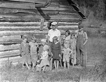
324:In 1933, during the construction of
168:0.00 sq mi (0.00 km)
160:1.62 sq mi (4.19 km)
152:1.62 sq mi (4.19 km)
638:Municipalities and communities of
535:"Census of Population and Housing"
379:
14:
595:
452:"ArcGIS REST Services Directory"
55:
40:
18:CDP in Tennessee, United States
1:
512:. Retrieved: March 20, 2009.
490:. United States Census Bureau
454:. United States Census Bureau
428:Köppen Climate Classification
197:313.97/sq mi (121.19/km)
430:system, Andersonville has a
288:Andersonville is located on
561:United States Census Bureau
942:
641:Anderson County, Tennessee
330:Tennessee Valley Authority
279:Anderson County, Tennessee
881:
704:
652:
432:humid subtropical climate
410:
395:
388:
383:
378:
375:
74:
54:
39:
30:
602:Andersonville, Tennessee
290:Tennessee State Route 61
275:unincorporated community
176:968 ft (295 m)
488:"Census Population API"
283:census-designated place
711:
508:Bureau of the Census,
337:
710:
557:"U.S. Census website"
411:U.S. Decennial Census
371:Historical population
323:
220: • Summer (
94:36.19500°N 84.04000°W
894:United States portal
604:at Wikimedia Commons
300:. The Andersonville
194: • Density
372:
99:36.19500; -84.04000
90: /
712:
370:
338:
186: • Total
165: • Water
149: • Total
903:
902:
822:King Arthur Court
600:Media related to
415:
414:
268:
267:
157: • Land
65:and the state of
933:
895:
888:
887:Tennessee portal
709:
664:
657:
647:
642:
632:
625:
618:
609:
599:
583:
578:
572:
571:
569:
567:
553:
547:
546:
544:
542:
531:
525:
522:About the School
519:
513:
506:
500:
499:
497:
495:
484:
478:
473:
464:
463:
461:
459:
448:
391:
386:
381:
373:
225:
105:
104:
102:
101:
100:
95:
91:
88:
87:
86:
83:
59:
49:in Andersonville
44:
21:
941:
940:
936:
935:
934:
932:
931:
930:
906:
905:
904:
899:
893:
886:
877:
867:
849:
842:
762:
755:
732:
713:
707:
702:
667:
662:
655:
648:
645:
640:
636:
592:
587:
586:
579:
575:
565:
563:
555:
554:
550:
540:
538:
533:
532:
528:
520:
516:
507:
503:
493:
491:
486:
485:
481:
474:
467:
457:
455:
450:
449:
445:
440:
424:
384:
368:
318:
243:
219:
98:
96:
92:
89:
84:
81:
79:
77:
76:
70:
63:Anderson County
50:
35:
26:
19:
12:
11:
5:
939:
937:
929:
928:
923:
918:
908:
907:
901:
900:
898:
897:
890:
882:
879:
878:
875:
873:
869:
868:
866:
865:
860:
854:
852:
844:
843:
841:
840:
835:
830:
825:
819:
813:
808:
803:
798:
793:
788:
783:
778:
773:
767:
765:
757:
756:
754:
753:
748:
742:
740:
734:
733:
731:
730:
727:Oliver Springs
723:
721:
715:
714:
705:
703:
701:
700:
694:
688:
683:
677:
675:
669:
668:
653:
650:
649:
637:
635:
634:
627:
620:
612:
606:
605:
591:
590:External links
588:
585:
584:
573:
548:
526:
514:
501:
479:
465:
442:
441:
439:
436:
423:
420:
413:
412:
408:
407:
404:
402:
399:
393:
392:
387:
382:
377:
367:
364:
317:
314:
266:
265:
262:
255:
254:
251:
245:
244:
241:
239:
233:
232:
226:
216:
215:
205:
199:
198:
195:
191:
190:
187:
183:
182:
178:
177:
174:
170:
169:
166:
162:
161:
158:
154:
153:
150:
146:
145:
141:
140:
135:
129:
128:
123:
117:
116:
113:
107:
106:
72:
71:
60:
52:
51:
45:
37:
36:
31:
28:
27:
24:
17:
13:
10:
9:
6:
4:
3:
2:
938:
927:
924:
922:
919:
917:
914:
913:
911:
896:
891:
889:
884:
883:
880:
874:
870:
864:
861:
859:
856:
855:
853:
851:
850:neighborhoods
845:
839:
836:
834:
831:
829:
826:
823:
820:
817:
814:
812:
809:
807:
806:Fork Mountain
804:
802:
799:
797:
794:
792:
789:
787:
784:
782:
779:
777:
774:
772:
769:
768:
766:
764:
758:
752:
749:
747:
746:Andersonville
744:
743:
741:
739:
735:
728:
725:
724:
722:
720:
716:
698:
695:
692:
689:
687:
684:
682:
679:
678:
676:
674:
670:
666:
665:
658:
651:
646:United States
643:
633:
628:
626:
621:
619:
614:
613:
610:
603:
598:
594:
593:
589:
582:
577:
574:
562:
558:
552:
549:
536:
530:
527:
523:
518:
515:
511:
505:
502:
489:
483:
480:
477:
472:
470:
466:
453:
447:
444:
437:
435:
433:
429:
421:
419:
409:
405:
403:
400:
398:
394:
374:
365:
363:
360:
355:
351:
347:
343:
335:
332:photographer
331:
327:
322:
315:
313:
311:
307:
303:
299:
296:and south of
295:
291:
286:
284:
280:
276:
272:
271:Andersonville
263:
260:
252:
250:
240:
238:
230:
227:
223:
213:
212:Eastern (EST)
209:
206:
204:
196:
188:
175:
167:
159:
151:
139:
136:
134:
127:
124:
122:
115:United States
114:
112:
103:
75:Coordinates:
68:
64:
58:
48:
43:
34:
29:
25:Andersonville
22:
16:
863:Robertsville
848:Ghost towns/
745:
660:
576:
564:. Retrieved
551:
539:. Retrieved
537:. Census.gov
529:
517:
504:
492:. Retrieved
482:
456:. Retrieved
446:
425:
416:
366:Demographics
342:grade school
339:
310:Union County
304:is assigned
287:
270:
269:
61:Location in
15:
811:Fraterville
771:Beech Grove
763:communities
656:County seat
494:October 15,
458:October 15,
354:dormitories
350:high school
302:post office
298:Norris Lake
97: /
910:Categories
838:Stainville
751:Briceville
438:References
334:Lewis Hine
326:Norris Dam
261:feature ID
181:Population
82:36°11′42″N
872:Footnotes
697:Rocky Top
691:Oak Ridge
249:FIPS code
237:ZIP codes
203:Time zone
173:Elevation
126:Tennessee
85:84°2′24″W
67:Tennessee
816:Heiskell
786:Braytown
306:zip code
292:east of
253:47-01220
138:Anderson
833:Medford
801:Devonia
796:Claxton
791:Buffalo
776:Belmont
681:Clinton
663:Clinton
566:May 14,
541:June 4,
422:Climate
316:History
264:1307594
111:Country
828:Marlow
781:Bethel
686:Norris
673:Cities
376:Census
359:Norris
294:Norris
273:is an
133:County
761:Other
346:stock
242:37705
231:(EDT)
229:UTC-4
208:UTC-5
121:State
47:SR 61
858:Elza
738:CDPs
719:Town
568:2011
543:2016
496:2022
460:2022
397:2020
385:Note
380:Pop.
259:GNIS
144:Area
401:508
277:in
222:DST
189:508
33:CDP
912::
659::
644:,
559:.
468:^
390:%±
328:,
824:‡
818:‡
729:‡
699:‡
693:‡
631:e
624:t
617:v
570:.
545:.
498:.
462:.
406:—
224:)
214:)
210:(
69:.
Text is available under the Creative Commons Attribution-ShareAlike License. Additional terms may apply.