471:
461:
50:
34:
654:
57:
261:
345:
in the northeast. A number of valleys cut across the peninsula; the most important are the
Grejsdal in the middle, the Eremitdal further north and the Rendal in the west.
667:
96:
470:
524:
492:
49:
195:
691:
502:
664:
460:
264:, whose fate was unknown until 1930, when it became known that Andrée had crash-landed on the pack ice and died on
676:
292:
219:
134:
20:
249:
326:
239:
658:
334:
365:
257:
211:
358:
308:
408:
377:
478:, a prominent mountain of reddish rock with a lighter stripe extending diagonally across its face.
430:
383:
338:
442:
418:
319:
448:
436:
424:
395:
401:
389:
330:
671:
342:
246:
497:
260:
in 1897. One of the aims of
Nathorst's 1899 venture was to search for traces of the lost
685:
312:
300:
288:
638:
354:
353:
Andrée Land is mountainous. The highest point is 2,360 m (7,740 ft) high
171:
412:
304:
33:
284:
272:
265:
253:
407:(1,303 m). Located at the SE end of Andrée Land on the fjord shore, opposite
325:
The peninsula is attached to the mainland on its northwestern side, with the
111:
98:
215:
207:
653:
372:
group to the NW of Andrée Land. Some of the other noteworthy peaks are:
369:
296:
243:
19:"Andrée Land" redirects here. For the peninsula in Spitsbergen, see
357:, also known as Margarita Spids, located in the southern part. The
589:
614:
549:
577:
Prostar
Sailing Directions 2005 Greenland and Iceland Enroute
364:
are a mountain range at the SW end rising above the
Isfjord.
318:
is located off the easternmost end of Andrée Land, north of
271:
The region was later visited and accurately mapped during
283:
Andrée Land is located about 100 km inland from the
665:
Den grønlandske Lods - Sejladsanvisninger Østgrønland
525:"Catalogue of place names in northern East Greenland"
191:
177:
167:
159:
151:
143:
127:
90:
82:
77:
16:Peninsula in King Christian X Land, East Greenland
295:in the southeast, and two branches of it, the
8:
677:Glacitectonic deformations in East Greenland
26:
544:
542:
329:in its western boundary, beyond which lies
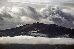
38:Mountain summits and clouds in Andrée Land
25:
572:
570:
469:
459:
513:
252:, who had made an attempt to reach the
519:
517:
493:Cartographic expeditions to Greenland
7:
56:
275:'s expeditions to East Greenland.
262:Andrée's Arctic Balloon Expedition
14:
69:Location of Andrée Land Peninsula
652:
474:1882 artist's impression of the
55:
48:
32:
311:, in the east. Small and rocky
527:. Geological Survey of Denmark
503:List of mountains in Greenland
464:Map of Northeastern Greenland.
1:
242:on his 1899 expedition after
341:flows in the north and the
238:The peninsula was named by
163:2,360 m (7740 ft)
708:
457:
196:NE Greenland National Park
18:
293:Kaiser Franz Joseph Fjord
220:Kejser Franz Joseph Fjord
182:
155:63 km (39.1 mi)
147:85 km (52.8 mi)
135:Kaiser Franz Joseph Fjord
43:
31:
138:Ijsfjord and Geologfjord
692:Peninsulas of Greenland
479:
465:
411:, the NW extremity of
337:in the northwest. The
327:Gerard De Geer Glacier
160:Highest elevation
21:Andrée Land (Svalbard)
473:
463:
250:Salomon August Andrée
212:King Christian X Land
661:at Wikimedia Commons
335:J. L. Mowinckel Land
307:, beyond which lies
303:— in the SW and the
299:—beyond which lies
218:that is bounded by
185:Greenland (Denmark)
108: /
28:
670:2020-10-28 at the
480:
466:
366:Arnold Escher Land
339:Adolf Hoel Glacier
168:Highest point
657:Media related to
484:
483:
359:Lacroix Mountains
291:. It is bound by
201:
200:
112:73.583°N 26.000°W
699:
656:
641:
636:
630:
629:
627:
625:
611:
605:
604:
602:
600:
586:
580:
574:
565:
564:
562:
560:
546:
537:
536:
534:
532:
521:
456:
455:
405:(Teufelsschloss)
362:(Lacroix Bjerge)
333:in the west and
331:Louise Boyd Land
130:
123:
122:
120:
119:
118:
113:
109:
106:
105:
104:
101:
59:
58:
52:
36:
29:
707:
706:
702:
701:
700:
698:
697:
696:
682:
681:
672:Wayback Machine
649:
644:
637:
633:
623:
621:
613:
612:
608:
598:
596:
588:
587:
583:
575:
568:
558:
556:
548:
547:
540:
530:
528:
523:
522:
515:
511:
489:
454:
351:
343:Nunatak Glacier
309:Strindberg Land
281:
247:Arctic explorer
236:
187:
139:
137:
128:
117:73.583; -26.000
116:
114:
110:
107:
102:
99:
97:
95:
94:
73:
72:
71:
70:
67:
66:
65:
64:
60:
39:
24:
17:
12:
11:
5:
705:
703:
695:
694:
684:
683:
680:
679:
674:
662:
648:
647:External links
645:
643:
642:
631:
606:
581:
566:
538:
512:
510:
507:
506:
505:
500:
495:
488:
485:
482:
481:
476:Teufelsschloss
467:
453:
452:
446:
440:
434:
428:
422:
416:
409:Cape Petersens
402:Devil's Castle
399:
393:
387:
381:
374:
350:
347:
280:
277:
235:
232:
199:
198:
193:
189:
188:
183:
180:
179:
178:Administration
175:
174:
169:
165:
164:
161:
157:
156:
153:
149:
148:
145:
141:
140:
133:
131:
125:
124:
92:
88:
87:
86:East Greenland
84:
80:
79:
75:
74:
68:
62:
61:
54:
53:
47:
46:
45:
44:
41:
40:
37:
15:
13:
10:
9:
6:
4:
3:
2:
704:
693:
690:
689:
687:
678:
675:
673:
669:
666:
663:
660:
655:
651:
650:
646:
640:
635:
632:
620:
616:
610:
607:
595:
591:
585:
582:
578:
573:
571:
567:
555:
551:
550:"Andrée Land"
545:
543:
539:
526:
520:
518:
514:
508:
504:
501:
499:
496:
494:
491:
490:
486:
477:
472:
468:
462:
458:
450:
447:
444:
441:
438:
435:
432:
429:
426:
423:
420:
417:
414:
410:
406:
403:
400:
397:
394:
391:
388:
385:
382:
379:
378:Aappalaatsiaq
376:
375:
373:
371:
367:
363:
360:
356:
348:
346:
344:
340:
336:
332:
328:
323:
321:
317:
314:
313:Bjorne Island
310:
306:
302:
301:Fraenkel Land
298:
294:
290:
289:Greenland Sea
286:
278:
276:
274:
269:
267:
263:
259:
255:
251:
248:
245:
241:
240:A.G. Nathorst
233:
231:
229:
225:
221:
217:
213:
209:
205:
197:
194:
190:
186:
181:
176:
173:
170:
166:
162:
158:
154:
150:
146:
142:
136:
132:
126:
121:
93:
89:
85:
81:
76:
51:
42:
35:
30:
22:
639:Google Earth
634:
622:. Retrieved
618:
615:"Grejsdalen"
609:
597:. Retrieved
593:
584:
576:
557:. Retrieved
553:
529:. Retrieved
498:Frænkel Land
475:
431:Marcia Bjerg
404:
384:Agardh Bjerg
361:
355:Margaretatop
352:
324:
315:
282:
270:
237:
227:
223:
203:
202:
184:
172:Margaretatop
659:Andree Land
413:Ymer Island
305:Geologfjord
228:Geologfjord
204:Andrée Land
129:Adjacent to
115: /
91:Coordinates
63:Andrée Land
27:Andrée Land
509:References
443:Mørkebjerg
419:Djævleborg
320:Cape Weber
285:Foster Bay
273:Lauge Koch
254:North Pole
590:"Bjørneø"
451:(2,163 m)
449:Tårnfjeld
445:(1,497 m)
439:(1,842 m)
437:Målebjerg
433:(1,460 m)
427:(1,987 m)
425:Knivbjerg
421:(1,800 m)
398:(2,052 m)
396:Alpebjerg
392:(1,498 m)
386:(1,820 m)
380:(1,998 m)
349:Mountains
316:(Bjørneø)
279:Geography
216:Greenland
208:peninsula
78:Geography
686:Category
668:Archived
619:Mapcarta
594:Mapcarta
579:, p. 120
554:Mapcarta
487:See also
83:Location
599:25 July
559:22 July
390:Ajorpoq
370:nunatak
297:Isfjord
287:of the
266:Kvitøya
258:balloon
244:Swedish
234:History
224:Isfjord
214:, East
103:26°00′W
100:73°35′N
624:7 July
531:7 July
144:Length
368:is a
206:is a
152:Width
626:2016
601:2019
561:2019
533:2019
226:and
192:Zone
256:by
210:in
688::
617:.
592:.
569:^
552:.
541:^
516:^
322:.
268:.
230:.
222:,
628:.
603:.
563:.
535:.
415:.
23:.
Text is available under the Creative Commons Attribution-ShareAlike License. Additional terms may apply.