30:. Anson's lands were divided into smaller parcels for development, and several streets were named either for his ships or for himself: George and Anson (from his own name), Scarborough and Squirrel (named for the ships he came to America on), and Centurion (the ship he made his fortune with). Scarborough and Centurion Streets correspond to modern Anson and Society Street, while Squirrel is now a part of Meeting Street. On April 24, 1838, the area was devastated by a fire that swept from the southwest to the northeast through the area. When rebuilding began, the state offered loans on the condition that brick was used. By the 1950s, the area had suffered from a serious decline, and the
116:
74:
102:
60:
88:
130:
46:
234:
156:
195:
115:
73:
65:
59:
31:
160:
101:
87:
23:
129:
107:
79:
45:
93:
27:
135:
121:
228:
51:
210:
197:
34:
developed a program to save the historic area using a revolving fund.
26:. In 1726, Captain George Anson acquired a 64-acre tract from
157:"CCPL - Charleston County Public Library - South, Carolina"
16:
Neighbourhood in
Charleston, South Carolina, United States
66:Benjamin Simons Neufville House, 72 Anson Street
8:
235:Neighborhoods in Charleston, South Carolina
108:Col. William Rhett House, 54 Hasell Street
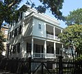
80:Middleton-Pinckney House, 14 George Street
148:
41:
122:Augustus Taft House, 57 Laurens Street
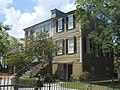
94:St. Johannes Rectory, 50 Hasell Street
7:
136:Daniel Legare House, 79 Anson Street
14:
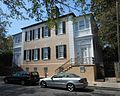
52:The Chazal House, 66 Anson Street
128:
114:
100:
86:
72:
58:
44:
32:Historic Charleston Foundation
1:
181:Poston, Jonathan H. (1997).
183:The Buildings of Charleston
251:
24:Charleston, South Carolina
22:is a neighborhood in
207: /
185:. pp. 411–414.
211:32.787°N 79.9300°W
242:
222:
221:
219:
218:
217:
216:32.787; -79.9300
212:
208:
205:
204:
203:
200:
187:
186:
178:
172:
171:
169:
168:
159:. Archived from
153:
132:
118:
104:
90:
76:
62:
48:
250:
249:
245:
244:
243:
241:
240:
239:
225:
224:
215:
213:
209:
206:
201:
198:
196:
194:
193:
191:
190:
180:
179:
175:
166:
164:
155:
154:
150:
145:
138:
133:
124:
119:
110:
105:
96:
91:
82:
77:
68:
63:
54:
49:
40:
17:
12:
11:
5:
248:
246:
238:
237:
227:
226:
189:
188:
173:
147:
146:
144:
141:
140:
139:
134:
127:
125:
120:
113:
111:
106:
99:
97:
92:
85:
83:
78:
71:
69:
64:
57:
55:
50:
43:
39:
36:
28:Thomas Gadsden
15:
13:
10:
9:
6:
4:
3:
2:
247:
236:
233:
232:
230:
223:
220:
184:
177:
174:
163:on 2015-09-30
162:
158:
152:
149:
142:
137:
131:
126:
123:
117:
112:
109:
103:
98:
95:
89:
84:
81:
75:
70:
67:
61:
56:
53:
47:
42:
37:
35:
33:
29:
25:
21:
192:
182:
176:
165:. Retrieved
161:the original
151:
20:Ansonborough
19:
18:
214: /
202:79°55′48″W
199:32°47′13″N
167:2015-08-28
143:References
229:Category
38:Gallery
231::
170:.
Text is available under the Creative Commons Attribution-ShareAlike License. Additional terms may apply.