58:
51:
750:. An ice-free peak which rises to 1,800 metres (5,900 ft) high between the foot of Wreath Valley and Albert Valley. Named by Advisory Committee on Antarctic Names (US-ACAN) (2005) after Maurice Conway of Thames, New Zealand; field guide in eight summer seasons for German expeditions to Victoria Land, Marie Byrd Land, and Queen Maud Land, 1979-2000; field guide/technician in six seasons, 1997-2004, for United States Antarctic Project (USAP) at Roosevelt Island and west Marie Byrd Land ice streams.
636:. The highest summit in Apocalypse Peaks, rising to 2,360 metres (7,740 ft) high west of Wreath Valley in the west part of the group. Named by Advisory Committee on Antarctic Names (US-ACAN) (2005) after astronomer Mark W. Dragovan, who (1986) collaborated with Yerkes engineer Robert J. Pernic to build a telescope to observe the early formation of structure in the universe; nine field seasons at the Amundsen-Scott South Pole Station Center for Astrophysical Research in Antarctica, 1988-2000.
235:
674:. A flat-topped ridge rising to 1,900 metres (6,200 ft) high northeast of Mount Dragovan. The ledge comprises the central part of the divide between Haselton Glacier and Wreath Valley. Named by US-ACAN (2005) after Matthew A. Lazzara of the United States Antarctic Project (USAP) Antarctic Meteorological Research Center field team, who worked in the McMurdo Station area and at other Antarctic locations in eight summer seasons, 1994-2004.
29:
1353:
1333:
1052:
796:. Named by US-ACAN (2005) after Gerd Wendler, Geophysical Institute, University of Alaska, Fairbanks, AK; a USAP member in an international collaboration (France, Australia, United States) to study katabatic winds and their interaction with sea ice at Adélie Coast and George V Coast; several field seasons 1979-2001.
359:. A hill, 2,100 metres (6,900 ft) high, at the extreme west end of the Apocalypse Peaks. The hill rises 100 metres (330 ft) high above the adjacent plateau ice, which diverges at the hill to the east-northeast-flowing Haselton Glacier and the east-flowing Huka Kapo Glacier. Named by
712:. An ice-free valley between Lazzara Ledge and Conway Peak. It is the westmost in a group of four aligned hanging valleys. So named by US-ACAN (2005) from an ice and rock formation on the valley headwall, which is wreathlike in appearance and visible from a great distance.
405:. It flows east, southward of Edbrooke Hill, and terminates nearly midway along the south side of Apocalypse Peaks. “Huka Kapo” is a Maori word, meaning driving hail, and was applied descriptively to this glacier by the New Zealand Geographic Board in 2005.
842:. Named by Advisory Committee on Antarctic Names (US-ACAN) (2005) after David Z. Besson, Physics Department, University of Kansas, Lawrence, KS; AMANDA and related research at Amundsen-Scott South Pole Station; eight field seasons 1997-2004.
447:. Named by the New Zealand Geographic Board (2005) after John Bryan, an Australian coal geologist who led a party in mapping the Permian coal measures at Mount Fleming, Shapeless Mountain, and Mount Electra during one visit in 1982-83.
363:(NZGB) (2005) after Steven Edbrooke, geologist, New Zealand Geological Survey, who mapped coal measures at Mount Fleming, Shapeless Mountain, and Mount Electra in 1982-83; in upper Wright Valley, Clare Range, and Willett Range, 1992-93.
1337:
1056:
528:. A glacier that occupies the upper portion of Papitashvili Valley. “Pūanu” is a Maori word, meaning intense cold, and was applied descriptively to this glacier in 2005 by the New Zealand Geographic Board.
489:
and
Papitashvili Valley. Named by the New Zealand Geographic Board (2005) after Geoffrey (Toby) Rose, leader of a party that investigated coal measures in the Mount Bastion and Sponsors Peak area, 1984-85.
570:. Named by the New Zealand Geographic Board (NZGB) (2005) after Ian Turnbull, an Institute of Geology and Nuclear Sciences geologist, who was a member of geology mapping parties at
215:
1394:
104:
1323:
1286:
1249:
1228:
1207:
1186:
1165:
1144:
1123:
1102:
1081:
50:
1060:
1423:
153:
1413:
1387:
1314:
1277:
1240:
1219:
1198:
1177:
1156:
1135:
1114:
1093:
1072:
1309:
1272:
1235:
1214:
1193:
1172:
1151:
1130:
1109:
1088:
1067:
1341:
1319:
1282:
1245:
1224:
1203:
1182:
1161:
1140:
1119:
1098:
1077:
223:
500:
415:
1380:
485:. A summit about 2,000 metres (6,600 ft) high at the south end of Wendler Spur. The feature stands between the head of
806:
722:
684:
646:
608:
457:
331:
538:
373:
760:
360:
97:
283:
587:
1418:
310:
305:
835:
793:
444:
234:
1293:
300:
579:
190:) are a group of peaks with a highest point of 2,360 metres (7,740 ft), standing east of
839:
567:
1256:
575:
1364:
583:
243:
195:
28:
1407:
1360:
789:
486:
402:
267:
251:
247:
203:
199:
191:
90:
1034:
571:
255:
1352:
295:
263:
259:
80:
821:
808:
775:
762:
737:
724:
699:
686:
661:
648:
623:
610:
553:
540:
515:
502:
472:
459:
430:
417:
388:
375:
346:
333:
169:
155:
120:
106:
566:. A peak rising to 1,600 metres (5,200 ft) high at the head of
233:
219:
598:
Features of the north of the peaks include, from west to east,
321:
Features of the south of the peaks include, from west to east,
1368:
856:
854:
216:
Victoria
University of Wellington Antarctic Expedition
1042:(2 ed.), United States Board on Geographic Names
590:areas in several field seasons 1988-89 to 1997-98.
96:
86:
76:
38:
21:
16:
896:
443:. A glacier that flows south from a divide with
956:
872:
222:slopes which gives them the appearance of the "
980:
968:
944:
932:
908:
884:
1388:
1004:
8:
1016:
992:
238:Insel Range north of center of mapped region
920:
1395:
1381:
834:. A rock spur that descends north between
788:. A rock spur that descends north between
214:The Apocalypse Peaks were so named by the
18:
1324:United States Department of the Interior
1287:United States Department of the Interior
1250:United States Department of the Interior
1229:United States Department of the Interior
1208:United States Department of the Interior
1187:United States Department of the Interior
1166:United States Department of the Interior
1145:United States Department of the Interior
1124:United States Department of the Interior
1103:United States Department of the Interior
1082:United States Department of the Interior
242:The Apocalypse Peaks are bounded by the
57:
1298:, AADC Australian Antarctic Data Centre
1261:, USGS: United States Geological Survey
1061:United States Board on Geographic Names
860:
850:
218:(1958–59) because the peaks are cut by
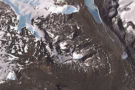
33:Satellite image of the Apocalypse Peaks
7:
1349:
1347:
1315:Geographic Names Information System
1278:Geographic Names Information System
1241:Geographic Names Information System
1220:Geographic Names Information System
1199:Geographic Names Information System
1178:Geographic Names Information System
1157:Geographic Names Information System
1136:Geographic Names Information System
1115:Geographic Names Information System
1094:Geographic Names Information System
1073:Geographic Names Information System
1340:from websites or documents of the
1059:from websites or documents of the
14:
1036:Geographic Names of the Antarctic
1351:
1336: This article incorporates
1331:
1055: This article incorporates
1050:
401:. A glacier from the plateau of
56:
49:
27:
1342:United States Geological Survey
1320:United States Geological Survey
1283:United States Geological Survey
1246:United States Geological Survey
1225:United States Geological Survey
1204:United States Geological Survey
1183:United States Geological Survey
1162:United States Geological Survey
1141:United States Geological Survey
1120:United States Geological Survey
1099:United States Geological Survey
1078:United States Geological Survey
1033:Alberts, Fred G., ed. (1995),
1:
1424:Victoria Land geography stubs
1367:. You can help Knowledge by
361:New Zealand Geographic Board
311:GPX (secondary coordinates)
1440:
1414:Mountains of Victoria Land
1346:
516:77.3916667°S 160.9777778°E
431:77.4041667°S 160.9291667°E
306:GPX (primary coordinates)
281:Map all coordinates using
266:to the southeast and the
246:to the northeast and the
43:
26:
822:77.383333°S 161.029167°E
738:77.370278°S 160.895833°E
700:77.378213°S 160.825878°E
662:77.376868°S 160.769899°E
624:77.381343°S 160.707434°E
521:-77.3916667; 160.9777778
473:77.390611°S 160.938061°E
436:-77.4041667; 160.9291667
347:77.394444°S 160.638333°E
289:Download coordinates as:
224:Riders of the Apocalypse
588:Wilson Piedmont Glacier
554:77.39048°S 161.021851°E
389:77.40134°S 160.700585°E
1363:location article is a
1338:public domain material
1057:public domain material
897:Huka Kapo Glacier USGS
827:-77.383333; 161.029167
776:77.37500°S 160.97500°E
743:-77.370278; 160.895833
705:-77.378213; 160.825878
667:-77.376868; 160.769899
629:-77.381343; 160.707434
478:-77.390611; 160.938061
352:-77.394444; 160.638333
258:(formerly part of the
254:lies to the west, the
250:to the southeast. The
239:
559:-77.39048; 161.021851
394:-77.40134; 160.700585
301:GPX (all coordinates)
237:
781:-77.37500; 160.97500
262:) to the north, the
1152:"Huka Kapo Glacier"
957:Mount Dragovan USGS
873:Taylor Glacier USGS
836:Papitashvili Valley
818: /
794:Papitashvili Valley
772: /
734: /
696: /
658: /
620: /
550: /
512: /
469: /
445:Papitashvili Valley
427: /
385: /
343: /
165: /
116: /
981:Wreath Valley USGS
969:Lazzara Ledge USGS
945:Turnbull Peak USGS
933:Pūanu Glacier USGS
909:Bryan Glacier USGS
885:Edbrooke Hill USGS
240:
170:77.383°S 160.850°E
121:77.383°S 160.850°E
1376:
1375:
1005:Wendler Spur AADC
594:Northern features
580:Saint Johns Range
367:Huka Kapo Glacier
274:Southern features
144:
143:
98:Range coordinates
1431:
1397:
1390:
1383:
1355:
1348:
1335:
1334:
1326:
1305:
1304:
1303:
1289:
1268:
1267:
1266:
1252:
1231:
1210:
1194:"Mount Dragovan"
1189:
1168:
1147:
1126:
1105:
1084:
1054:
1053:
1049:
1048:
1047:
1041:
1020:
1017:Besson Spur USGS
1014:
1008:
1002:
996:
993:Conway Peak USGS
990:
984:
978:
972:
966:
960:
954:
948:
942:
936:
930:
924:
918:
912:
906:
900:
894:
888:
882:
876:
870:
864:
858:
840:Hernandez Valley
833:
832:
830:
829:
828:
823:
819:
816:
815:
814:
811:
787:
786:
784:
783:
782:
777:
773:
770:
769:
768:
765:
749:
748:
746:
745:
744:
739:
735:
732:
731:
730:
727:
711:
710:
708:
707:
706:
701:
697:
694:
693:
692:
689:
673:
672:
670:
669:
668:
663:
659:
656:
655:
654:
651:
635:
634:
632:
631:
630:
625:
621:
618:
617:
616:
613:
568:Hernandez Valley
565:
564:
562:
561:
560:
555:
551:
548:
547:
546:
543:
527:
526:
524:
523:
522:
517:
513:
510:
509:
508:
505:
484:
483:
481:
480:
479:
474:
470:
467:
466:
465:
462:
442:
441:
439:
438:
437:
432:
428:
425:
424:
423:
420:
400:
399:
397:
396:
395:
390:
386:
383:
382:
381:
378:
358:
357:
355:
354:
353:
348:
344:
341:
340:
339:
336:
189:
188:
186:
185:
184:
182:
181:Apocalypse Peaks
177:
176:
175:-77.383; 160.850
171:
166:
163:
162:
161:
158:
148:Apocalypse Peaks
140:
139:
137:
136:
135:
133:
132:Apocalypse Peaks
128:
127:
126:-77.383; 160.850
122:
117:
114:
113:
112:
109:
64:Apocalypse Peaks
60:
59:
53:
31:
22:Apocalypse Peaks
19:
1439:
1438:
1434:
1433:
1432:
1430:
1429:
1428:
1404:
1403:
1402:
1401:
1332:
1329:
1310:"Wreath Valley"
1308:
1301:
1299:
1292:
1273:"Turnbull Peak"
1271:
1264:
1262:
1255:
1234:
1215:"Pūanu Glacier"
1213:
1192:
1173:"Lazzara Ledge"
1171:
1150:
1131:"Edbrooke Hill"
1129:
1108:
1089:"Bryan Glacier"
1087:
1066:
1051:
1045:
1043:
1039:
1032:
1028:
1023:
1015:
1011:
1003:
999:
991:
987:
979:
975:
967:
963:
955:
951:
943:
939:
931:
927:
921:Rose Crest USGS
919:
915:
907:
903:
895:
891:
883:
879:
871:
867:
859:
852:
848:
826:
824:
820:
817:
812:
809:
807:
805:
804:
802:
780:
778:
774:
771:
766:
763:
761:
759:
758:
756:
742:
740:
736:
733:
728:
725:
723:
721:
720:
718:
704:
702:
698:
695:
690:
687:
685:
683:
682:
680:
666:
664:
660:
657:
652:
649:
647:
645:
644:
642:
628:
626:
622:
619:
614:
611:
609:
607:
606:
604:
596:
576:Victoria Valley
558:
556:
552:
549:
544:
541:
539:
537:
536:
534:
520:
518:
514:
511:
506:
503:
501:
499:
498:
496:
477:
475:
471:
468:
463:
460:
458:
456:
455:
453:
435:
433:
429:
426:
421:
418:
416:
414:
413:
411:
393:
391:
387:
384:
379:
376:
374:
372:
371:
369:
351:
349:
345:
342:
337:
334:
332:
330:
329:
327:
319:
318:
317:
316:
315:
276:
232:
212:
180:
178:
174:
172:
168:
167:
164:
159:
156:
154:
152:
151:
131:
129:
125:
123:
119:
118:
115:
110:
107:
105:
103:
102:
72:
71:
70:
69:
68:
67:
66:
65:
61:
34:
17:
12:
11:
5:
1437:
1435:
1427:
1426:
1421:
1416:
1406:
1405:
1400:
1399:
1392:
1385:
1377:
1374:
1373:
1356:
1328:
1327:
1306:
1290:
1269:
1258:Taylor Glacier
1253:
1232:
1211:
1190:
1169:
1148:
1127:
1106:
1085:
1064:
1029:
1027:
1024:
1022:
1021:
1009:
997:
985:
973:
961:
949:
937:
925:
913:
901:
889:
877:
865:
849:
847:
844:
801:
798:
755:
752:
717:
714:
679:
676:
641:
638:
603:
602:Mount Dragovan
600:
595:
592:
584:Mackay Glacier
533:
530:
495:
492:
452:
449:
410:
407:
368:
365:
326:
323:
314:
313:
308:
303:
298:
292:
286:
279:
278:
277:
275:
272:
270:to the south.
244:Barwick Valley
231:
228:
211:
208:
206:, Antarctica.
196:Barwick Valley
142:
141:
100:
94:
93:
88:
84:
83:
78:
74:
73:
63:
62:
55:
54:
48:
47:
46:
45:
44:
41:
40:
36:
35:
32:
24:
23:
15:
13:
10:
9:
6:
4:
3:
2:
1436:
1425:
1422:
1420:
1419:Pennell Coast
1417:
1415:
1412:
1411:
1409:
1398:
1393:
1391:
1386:
1384:
1379:
1378:
1372:
1370:
1366:
1362:
1361:Victoria Land
1357:
1354:
1350:
1345:
1343:
1339:
1325:
1321:
1317:
1316:
1311:
1307:
1297:
1296:
1291:
1288:
1284:
1280:
1279:
1274:
1270:
1260:
1259:
1254:
1251:
1247:
1243:
1242:
1237:
1233:
1230:
1226:
1222:
1221:
1216:
1212:
1209:
1205:
1201:
1200:
1195:
1191:
1188:
1184:
1180:
1179:
1174:
1170:
1167:
1163:
1159:
1158:
1153:
1149:
1146:
1142:
1138:
1137:
1132:
1128:
1125:
1121:
1117:
1116:
1111:
1110:"Conway Peak"
1107:
1104:
1100:
1096:
1095:
1090:
1086:
1083:
1079:
1075:
1074:
1069:
1068:"Besson Spur"
1065:
1062:
1058:
1038:
1037:
1031:
1030:
1025:
1018:
1013:
1010:
1006:
1001:
998:
994:
989:
986:
982:
977:
974:
970:
965:
962:
958:
953:
950:
946:
941:
938:
934:
929:
926:
922:
917:
914:
910:
905:
902:
898:
893:
890:
886:
881:
878:
874:
869:
866:
863:, p. 24.
862:
857:
855:
851:
845:
843:
841:
837:
831:
799:
797:
795:
791:
790:Albert Valley
785:
753:
751:
747:
715:
713:
709:
678:Wreath Valley
677:
675:
671:
640:Lazzara Ledge
639:
637:
633:
601:
599:
593:
591:
589:
585:
582:, and at the
581:
577:
573:
569:
563:
532:Turnbull Peak
531:
529:
525:
494:Pūanu Glacier
493:
491:
488:
487:Albert Valley
482:
450:
448:
446:
440:
409:Bryan Glacier
408:
406:
404:
403:Willett Range
398:
366:
364:
362:
356:
325:Edbrooke Hill
324:
322:
312:
309:
307:
304:
302:
299:
297:
294:
293:
291:
290:
285:
284:OpenStreetMap
282:
273:
271:
269:
268:Olympus Range
265:
261:
257:
253:
252:Willett Range
249:
248:Balham Valley
245:
236:
229:
227:
225:
221:
217:
209:
207:
205:
204:Victoria Land
201:
200:Balham Valley
197:
193:
192:Willett Range
187:
149:
138:
101:
99:
95:
92:
91:Victoria Land
89:
85:
82:
79:
75:
52:
42:
37:
30:
25:
20:
1369:expanding it
1358:
1330:
1313:
1300:, retrieved
1295:Wendler Spur
1294:
1276:
1263:, retrieved
1257:
1239:
1236:"Rose Crest"
1218:
1197:
1176:
1155:
1134:
1113:
1092:
1071:
1044:, retrieved
1035:
1012:
1000:
988:
976:
964:
952:
940:
928:
916:
904:
892:
880:
868:
861:Alberts 1995
803:
757:
754:Wendler Spur
719:
681:
643:
605:
597:
572:Asgard Range
535:
497:
454:
412:
370:
328:
320:
288:
287:
280:
256:Cruzen Range
241:
213:
194:and between
147:
145:
825: /
813:161°01′45″E
800:Besson Spur
779: /
767:160°58′30″E
741: /
729:160°53′45″E
716:Conway Peak
703: /
691:160°49′33″E
665: /
653:160°46′12″E
627: /
615:160°42′27″E
557: /
545:161°01′19″E
519: /
507:160°58′40″E
476: /
464:160°56′17″E
434: /
422:160°55′45″E
392: /
380:160°42′02″E
350: /
338:160°38′18″E
264:Insel Range
260:Clare Range
173: /
124: /
1408:Categories
1302:2024-02-19
1265:2024-02-13
1046:2024-01-30
846:References
810:77°23′00″S
764:77°22′30″S
726:77°22′13″S
688:77°22′42″S
650:77°22′37″S
612:77°22′53″S
542:77°23′26″S
504:77°23′30″S
461:77°23′26″S
451:Rose Crest
419:77°24′15″S
377:77°24′05″S
335:77°23′40″S
179: (
130: (
81:Antarctica
77:Continent
39:Geography
230:Location
160:160°51′E
111:160°51′E
1026:Sources
157:77°23′S
108:77°23′S
87:Region
1359:This
1040:(PDF)
220:talus
202:, in
1365:stub
838:and
792:and
586:and
210:Name
198:and
146:The
296:KML
226:."
1410::
1344:.
1322:,
1318:,
1312:,
1285:,
1281:,
1275:,
1248:,
1244:,
1238:,
1227:,
1223:,
1217:,
1206:,
1202:,
1196:,
1185:,
1181:,
1175:,
1164:,
1160:,
1154:,
1143:,
1139:,
1133:,
1122:,
1118:,
1112:,
1101:,
1097:,
1091:,
1080:,
1076:,
1070:,
853:^
578:,
574:,
1396:e
1389:t
1382:v
1371:.
1063:.
1019:.
1007:.
995:.
983:.
971:.
959:.
947:.
935:.
923:.
911:.
899:.
887:.
875:.
183:)
150:(
134:)
Text is available under the Creative Commons Attribution-ShareAlike License. Additional terms may apply.