38:
374:
362:
73:
386:
106:
398:
53:
719:
113:
80:
343:. The tower of Dutch Reformed Church is from the 12th century. The choir dates around 1400. In 1859, the church and tower were modified into a single building. Huis Appeltern was a manor house built in the late-17th century. It was demolished in 1881 and only the northern wing remains. In 1840, Appeltern was home to 567 people.
37:
599:
350:
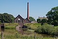
De Tuut was constructed between 1918 and 1919 as one of the last steam powered pumping station. It was decommissioned in 1969 when it was replaced by the Diesel powered
Bloemers pumping station.
373:
361:
592:
700:
760:
585:
72:
779:
197:
784:
289:
385:
301:
794:
105:
753:
609:
545:
141:
746:
281:
185:
339:
It was first mentioned in 1139 as de
Apeltre, and means "settlement near apple trees". The village developed along the
789:
397:
52:
173:
577:
537:
260:
270:
648:
613:
541:
324:
202:
730:
627:
347:
427:
773:
663:
718:
689:
507:
316:
178:
726:
632:
320:
190:
156:
143:
251:
653:
481:
668:
277:
256:
673:
340:
452:
581:
328:
571:
331:. Until 1984, Appeltern was an independent municipality.
734:
682:
641:
620:
300:
288:
267:
250:
242:
234:
229:
221:
213:
208:
196:
184:
172:
21:
701:List of cities, towns and villages in Gelderland
536:Ronald Stenvert & Sabine Broekhoven (2000).
754:
593:
8:
761:
747:
600:
586:
578:
531:
529:
18:
476:
474:
327:, and lies about 9 km northeast of
414:
357:
287:
249:
228:
220:
207:
171:
136:
64:
46:
34:
422:
420:
418:
323:. It is a part of the municipality of
299:
266:
241:
233:
212:
195:
183:
7:
715:
713:
428:"Kerncijfers wijken en buurten 2021"
379:Pumping station: stoomgemaal de Tuut
780:Former municipalities of Gelderland
217:6.33 km (2.44 sq mi)
733:. You can help Knowledge (XXG) by
16:Village in Gelderland, Netherlands
14:
508:"Appeltern - (geografische naam)"
112:
79:
717:
396:
384:
372:
360:
111:
104:
78:
71:
51:
36:
459:(in Dutch). Het Waterschapshuis
457:Actueel Hoogtebestand Nederland
785:Populated places in Gelderland
540:(in Dutch). Zwolle: Waanders.
367:Church, the Sint Servatiuskerk
1:
432:Central Bureau of Statistics
92:Location in the Netherlands
811:
795:Gelderland geography stubs
712:
698:
453:"Postcodetool for 6629AA"
137:
65:
47:
35:
28:
608:Populated places in the
572:De Tuinen van Appeltern
391:The Maas near Appeltern
246:130/km (330/sq mi)
128:Show map of Netherlands
125:Appeltern (Netherlands)
729:location article is a
95:Show map of Gelderland
269: • Summer (
225:7 m (23 ft)
315:is a village in the
243: • Density
403:Garden of Appeltern
153: /
42:View on the village
649:Alphen aan de Maas
235: • Total
214: • Total
790:West Maas en Waal
742:
741:
707:
706:
614:West Maas en Waal
325:West Maas en Waal
310:
309:
203:West Maas en Waal
802:
763:
756:
749:
721:
714:
602:
595:
588:
579:
559:
558:
556:
554:
533:
524:
523:
521:
519:
504:
498:
497:
495:
493:
478:
469:
468:
466:
464:
449:
443:
442:
440:
438:
424:
400:
388:
376:
364:
274:
168:
167:
165:
164:
163:
158:
157:51.833°N 5.583°E
154:
151:
150:
149:
146:
129:
115:
114:
108:
96:
82:
81:
75:
55:
40:
19:
810:
809:
805:
804:
803:
801:
800:
799:
770:
769:
768:
767:
710:
708:
703:
694:
678:
637:
628:Beneden-Leeuwen
616:
606:
568:
563:
562:
552:
550:
548:
535:
534:
527:
517:
515:
506:
505:
501:
491:
489:
480:
479:
472:
462:
460:
451:
450:
446:
436:
434:
426:
425:
416:
411:
404:
401:
392:
389:
380:
377:
368:
365:
356:
348:pumping station
337:
296:
268:
161:
159:
155:
152:
147:
144:
142:
140:
139:
133:
132:
131:
130:
127:
126:
123:
122:
121:
120:
116:
99:
98:
97:
94:
93:
90:
89:
88:
87:
83:
61:
60:
59:
58:
43:
31:
24:
17:
12:
11:
5:
808:
806:
798:
797:
792:
787:
782:
772:
771:
766:
765:
758:
751:
743:
740:
739:
722:
705:
704:
699:
696:
695:
693:
692:
686:
684:
680:
679:
677:
676:
671:
666:
661:
656:
651:
645:
643:
639:
638:
636:
635:
630:
624:
622:
618:
617:
607:
605:
604:
597:
590:
582:
576:
575:
567:
566:External links
564:
561:
560:
546:
525:
512:Etymologiebank
499:
470:
444:
413:
412:
410:
407:
406:
405:
402:
395:
393:
390:
383:
381:
378:
371:
369:
366:
359:
355:
352:
336:
333:
308:
307:
304:
298:
297:
294:
292:
286:
285:
275:
265:
264:
254:
248:
247:
244:
240:
239:
236:
232:
231:
227:
226:
223:
219:
218:
215:
211:
210:
206:
205:
200:
194:
193:
188:
182:
181:
176:
170:
169:
135:
134:
124:
118:
117:
110:
109:
103:
102:
101:
100:
91:
85:
84:
77:
76:
70:
69:
68:
67:
66:
63:
62:
56:
50:
49:
48:
45:
44:
41:
33:
32:
29:
26:
25:
22:
15:
13:
10:
9:
6:
4:
3:
2:
807:
796:
793:
791:
788:
786:
783:
781:
778:
777:
775:
764:
759:
757:
752:
750:
745:
744:
738:
736:
732:
728:
723:
720:
716:
711:
702:
697:
691:
688:
687:
685:
681:
675:
672:
670:
667:
665:
664:Boven-Leeuwen
662:
660:
657:
655:
652:
650:
647:
646:
644:
640:
634:
631:
629:
626:
625:
623:
619:
615:
611:
603:
598:
596:
591:
589:
584:
583:
580:
573:
570:
569:
565:
549:
547:90 400 9406 3
543:
539:
532:
530:
526:
513:
509:
503:
500:
487:
483:
477:
475:
471:
458:
454:
448:
445:
433:
429:
423:
421:
419:
415:
408:
399:
394:
387:
382:
375:
370:
363:
358:
353:
351:
349:
344:
342:
334:
332:
330:
326:
322:
318:
314:
305:
303:
293:
291:
283:
279:
276:
272:
262:
258:
255:
253:
245:
237:
224:
216:
204:
201:
199:
192:
189:
187:
180:
177:
175:
166:
162:51.833; 5.583
138:Coordinates:
107:
74:
54:
39:
27:
20:
735:expanding it
724:
709:
658:
610:municipality
551:. Retrieved
516:. Retrieved
511:
502:
490:. Retrieved
486:Plaatsengids
485:
461:. Retrieved
456:
447:
435:. Retrieved
431:
345:
338:
319:province of
312:
311:
302:Dialing code
198:Municipality
57:Coat of arms
690:Moordhuizen
538:"Appeltern"
482:"Appeltern"
290:Postal code
179:Netherlands
160: /
774:Categories
727:Gelderland
633:Maasbommel
514:(in Dutch)
488:(in Dutch)
409:References
321:Gelderland
230:Population
191:Gelderland
659:Appeltern
574:(gardens)
313:Appeltern
252:Time zone
222:Elevation
119:Appeltern
86:Appeltern
23:Appeltern
654:Altforst
642:Villages
553:25 March
518:25 March
492:25 March
463:25 March
437:25 March
186:Province
683:Hamlets
669:Dreumel
354:Gallery
335:History
174:Country
145:51°50′N
30:Village
544:
346:Steam
148:5°35′E
725:This
674:Wamel
621:Towns
317:Dutch
278:UTC+2
257:UTC+1
731:stub
555:2022
542:ISBN
520:2022
494:2022
465:2022
439:2022
341:Maas
306:0487
295:6629
282:CEST
209:Area
612:of
329:Oss
271:DST
261:CET
238:805
776::
528:^
510:.
484:.
473:^
455:.
430:.
417:^
762:e
755:t
748:v
737:.
601:e
594:t
587:v
557:.
522:.
496:.
467:.
441:.
284:)
280:(
273:)
263:)
259:(
Text is available under the Creative Commons Attribution-ShareAlike License. Additional terms may apply.