156:
123:
116:
408:
149:
428:
29:
264:, a topographer who worked on the early map of the park. It is reported that he inquired from his Indian guide what word the Blackfeet used for "looking over something," and the guide, misunderstanding the meaning of his question, gave him the name "Appistoki," for the Indian god who looks over everything and everyone." Appistoki Peak rises on the southeast shore of
281:
364:
497:
473:
507:
492:
148:
343:
115:
466:
71:
334:
459:
339:
215:
64:
261:
249:
329:
435:
407:
185:
54:
269:
502:
265:
443:
388:
210:
196:
486:
189:
412:
228:
304:
245:
203:
427:
253:
86:
73:
28:
439:
257:
44:
406:
282:
Mountains and mountain ranges of
Glacier National Park (U.S.)
447:
369:(Map). TopoQwest (United States Geological Survey Maps)
227:
222:
209:
195:
181:
102:
63:
53:
43:
38:
21:
244:(8,169 feet (2,490 m)) is located in the
467:
8:
474:
460:
18:
498:Mountains of Glacier National Park (U.S.)
344:United States Department of the Interior
508:Glacier County, Montana geography stubs
293:
155:
122:
7:
493:Mountains of Glacier County, Montana
424:
422:
299:
297:
335:Geographic Names Information System
446:. You can help Knowledge (XXG) by
16:Mountain in Montana, United States
14:
268:and is a short distance north of
426:
260:. Appistoki Peak, "was named by
154:
147:
121:
114:
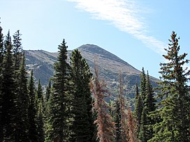
33:Appistoki Peak from Two Medicine
27:
340:United States Geological Survey
1:
171:Show map of the United States
168:Location in the United States
442:state location article is a
411:Appistoki Peak (right) from
49:8,169 ft (2,490 m)
524:
421:
366:Dancing Lady Mountain, MT
305:"Appistoki Peak, Montana"
107:
26:
59:497 ft (151 m)
391:. National Park Service
186:Glacier County, Montana
416:
389:"Historic Place Names"
87:48.46778°N 113.35417°W
410:
250:Glacier National Park
92:48.46778; -113.35417
138:Show map of Montana
135:Location in Montana
83: /
417:
39:Highest point
455:
454:
266:Two Medicine Lake
239:
238:
218:Squaw Mountain MT
515:
476:
469:
462:
430:
423:
401:
400:
398:
396:
385:
379:
378:
376:
374:
361:
355:
354:
352:
350:
330:"Appistoki Peak"
326:
320:
319:
317:
315:
301:
231:
199:
172:
158:
157:
151:
139:
125:
124:
118:
98:
97:
95:
94:
93:
88:
84:
81:
80:
79:
76:
31:
19:
523:
522:
518:
517:
516:
514:
513:
512:
483:
482:
481:
480:
419:
405:
404:
394:
392:
387:
386:
382:
372:
370:
363:
362:
358:
348:
346:
328:
327:
323:
313:
311:
303:
302:
295:
290:
278:
229:
197:
177:
176:
175:
174:
173:
170:
169:
166:
165:
164:
163:
159:
142:
141:
140:
137:
136:
133:
132:
131:
130:
126:
91:
89:
85:
82:
77:
74:
72:
70:
69:
34:
17:
12:
11:
5:
521:
519:
511:
510:
505:
500:
495:
485:
484:
479:
478:
471:
464:
456:
453:
452:
436:Glacier County
431:
403:
402:
380:
356:
321:
309:Peakbagger.com
292:
291:
289:
286:
285:
284:
277:
274:
242:Appistoki Peak
237:
236:
233:
225:
224:
220:
219:
213:
207:
206:
201:
193:
192:
183:
179:
178:
167:
162:Appistoki Peak
161:
160:
153:
152:
146:
145:
144:
143:
134:
129:Appistoki Peak
128:
127:
120:
119:
113:
112:
111:
110:
109:
108:
105:
104:
100:
99:
67:
61:
60:
57:
51:
50:
47:
41:
40:
36:
35:
32:
24:
23:
22:Appistoki Peak
15:
13:
10:
9:
6:
4:
3:
2:
520:
509:
506:
504:
501:
499:
496:
494:
491:
490:
488:
477:
472:
470:
465:
463:
458:
457:
451:
449:
445:
441:
437:
432:
429:
425:
420:
414:
409:
390:
384:
381:
368:
367:
360:
357:
345:
341:
337:
336:
331:
325:
322:
310:
306:
300:
298:
294:
287:
283:
280:
279:
275:
273:
271:
267:
263:
259:
255:
251:
247:
243:
234:
232:
230:Easiest route
226:
221:
217:
214:
212:
208:
205:
202:
200:
194:
191:
187:
184:
180:
150:
117:
106:
101:
96:
68:
66:
62:
58:
56:
52:
48:
46:
42:
37:
30:
25:
20:
448:expanding it
433:
418:
413:Scenic Point
393:. Retrieved
383:
371:. Retrieved
365:
359:
347:. Retrieved
333:
324:
312:. Retrieved
308:
241:
240:
198:Parent range
503:Lewis Range
270:Mount Henry
262:R. T. Evans
246:Lewis Range
204:Lewis Range
90: /
78:113°21′15″W
65:Coordinates
487:Categories
288:References
254:U.S. state
55:Prominence
395:August 2,
373:August 2,
349:August 2,
314:August 2,
103:Geography
75:48°28′4″N
45:Elevation
276:See also
223:Climbing
211:Topo map
182:Location
440:Montana
258:Montana
252:in the
434:This
415:Trail
444:stub
397:2017
375:2017
351:2017
316:2017
235:Hike
216:USGS
190:U.S.
256:of
489::
438:,
342:,
338:.
332:.
307:.
296:^
272:.
248:,
188:,
475:e
468:t
461:v
450:.
399:.
377:.
353:.
318:.
Text is available under the Creative Commons Attribution-ShareAlike License. Additional terms may apply.