240:
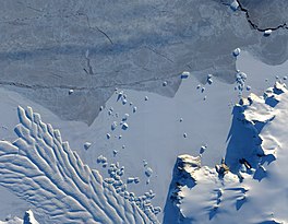
cracks, in the ice. After passing through the channel, the glacier has room to spread out as it floats on the ocean. The expanded area and the jostling of ocean waves prompts the ice to break apart, which it often does along existing crevasses. Matusevich
Glacier does not drain a significant amount of ice off of the Antarctic continent, so the glacier's advances and retreats lack global significance. Like other Antarctic glaciers, however, Matusevich helps glaciologists form a larger picture of Antarctica's glacial health and ice sheet volume.
56:
40:
1185:
63:
495:. A bay about 4 nautical miles (7.4 km; 4.6 mi) wide indenting the coast between Archer Point and Williamson Head. Photographed from the air by United States Navy Operation Highjump in 1947. Sketched and photographed by Phillip Law, leader of ANARE (Magga Dan) on Feb. 20, 1959. Named by ANCA for Capt. Harald M011er Pederson, master of the Magga Dan during the expedition.
845:
829:
773:
882:
239:
The glacier flows toward the coast of East
Antarctica, pushing through a channel between the Lazarev Mountains and the north-western tip of the Wilson terrain. Constrained by surrounding rocks, the river of ice holds together. But stresses resulting from the glacier's movement make deep crevasses, or
370:
in forming the west side of the bay. Photographed from the air by United States Navy
Operation Highjump in 1947. Sketched and photographed by Phillip Law, leader of ANARE (Magga Dan) on Feb. 20, 1959. Named by ANCA for Knud Lauritzen, shipowner of Copenhagen, Denmark, owner of Magga Dan and other
248:
The
Matusevich Glacier runs north to the southern ocean between the Lazerev Mountains and the Wilson Hills. It terminates in the Southern Ocean in a tongue between Lauritzen Bay and Harald Bay. Babushkin Island and the Terra Nova Islands are north of the tongue. Features of the Wilson Hills to the
577:. A small coastal island lying in the west part of the mouth of Harald Bay. Photographed by United States Navy Operation Highjump (1946-47), the Soviet Antarctic Expedition (1957-58) and ANARE (1959). The island was named Ostrov Kartografov (cartographers' island) by the Soviet expedition.
409:. Small island lying 5.5 nautical miles (10.2 km; 6.3 mi) north of Archer Point and 5 nautical miles (9.3 km; 5.8 mi) east of Matusevich Glacier Tongue. Mapped by the SovAE (1958) and named for Mikhail S. Babushkin (1893-1938), Soviet polar aviator lost in the Arctic.
615:. A prominent cape 6 nautical miles (11 km; 6.9 mi) west-northwest of Drake Head on the coast of Antarctica. Discovered from the Terra Nova in February 1911 during Scott's last expedition. Named for Petty Officer Thomas S. Williamson, Royal Navy, a member of the expedition.
453:. Two small islands lying off the Antarctic coast about 14 nautical miles (26 km; 16 mi) north of Williamson Head. Sighted from the Magga Dan, Mar. 8, 1961, by ANARE under Phillip Law. Named by ANCA after the expedition ship of the BrAE, 1910-13, the
533:. A rocky point on the coast marking the west side of Harald Bay. Discovered in Feb. 1911 by Lt. H.L.L. Pennell, RN, in the Terra Nova, expedition ship of the BrAE, 1910-13, under Scott. Named after W.W. Archer, chief steward of the expedition.
833:
777:
366:. A bay about 12 nautical miles (22 km; 14 mi) wide, occupied by bay ice and ice shell, indenting the coast between Cape Yevgenov and Coombes Ridge. The Matusevich Glacier Tongue joins
1023:
1073:
993:
988:
914:
321:
224:
1230:
1157:
1068:
1033:
942:
937:
1099:
1063:
998:
55:
1038:
1053:
1008:
907:
781:
811:
106:
1223:
1150:
328:, sailed around the tongue, February 21, 1959, at which time the seaward extremity was determined to be floating in 300 fathoms of ocean.
1048:
1043:
1013:
859:
973:
958:
900:
854:
1254:
1078:
1058:
963:
923:
265:. Coastal features around Harald Bay to the east include, from west to east, Archer Point, Kartografov Island, Williamson Head. The
978:
1249:
1216:
1143:
1083:
1028:
983:
864:
837:
1166:
1018:
968:
1114:
1109:
1003:
316:
about 18 nautical miles (33 km; 21 mi) long which is the broad seaward extension of the
Matusevich Glacier. The
200:
99:
587:
549:
505:
467:
425:
381:
338:
228:
220:
163:
284:
195:
about 50 nautical miles (93 km; 58 mi) long, with a well developed glacier tongue, flowing to the coast of
849:
872:
254:
798:
262:
542:
418:
216:
82:
227:, 1959 and 1962. It was named by the Soviet expedition after Nikolai Nikolayevich Matusevich, a
317:
807:
1119:
886:
457:, from which Lt. H.L.L. Pennell, RN, discovered and charted coastal points in the vicinity.
788:
266:
196:
92:
1200:
313:
258:
149:
1243:
367:
1124:
755:
250:
204:
39:
325:
1184:
1196:
602:
589:
564:
551:
520:
507:
482:
469:
440:
427:
396:
383:
353:
340:
299:
286:
178:
165:
121:
108:
892:
17:
1135:
1104:
1192:
192:
646:
644:
1139:
896:
44:
Natural-colour image of the margin of
Matusevich Glacier.
733:
731:
631:
629:
627:
1204:
870:
763:(2 ed.), United States Board on Geographic Names
1092:
951:
930:
650:
145:
137:
98:
88:
78:
32:
322:Australian National Antarctic Research Expeditions
225:Australian National Antarctic Research Expeditions
1224:
1151:
908:
8:
800:SR 57-58 2023 Edition Map Catalogue No.15582
1231:
1217:
1158:
1144:
1136:
1100:List of Antarctic and subantarctic islands
915:
901:
893:
62:
29:
662:
215:The region was photographed by U.S. Navy
877:
806:, Australian Antarctic Division, 2023,
782:United States Board on Geographic Names
737:
722:
710:
698:
686:
674:
635:
623:
943:List of glaciers in the Antarctic: I–Z
938:List of glaciers in the Antarctic: A–H
203:and the northwestern extremity of the
7:
1181:
1179:
141:50 nmi (93 km; 58 mi)
860:Geographic Names Information System
249:east include, from south to north,
1024:Palmer Archipelago and Graham Land
836:from websites or documents of the
780:from websites or documents of the
371:vessels used by ANARE since 1954.
25:
1074:Trinity Peninsula and Graham Land
994:James Ross Island and Graham Land
989:Heard Island and McDonald Islands
757:Geographic Names of the Antarctic
1183:
880:
848: This article incorporates
843:
832: This article incorporates
827:
776: This article incorporates
771:
61:
54:
38:
865:United States Geological Survey
838:United States Geological Survey
754:Alberts, Fred G., ed. (1995),
1:
1125:List of subantarctic glaciers
1115:List of Antarctic ice streams
1110:List of Antarctic ice shelves
1203:. You can help Knowledge by
1105:List of Antarctic ice rises
221:Soviet Antarctic Expedition
1271:
1178:
540:
416:
70:Location within Antarctica
924:Glaciers in the Antarctic
278:Matusevich Glacier Tongue
49:
37:
1255:Oates Land glacier stubs
1034:Princess Elizabeth Land
651:Matusevich Glacier NASA
320:, vessel of the ANARE (
269:is east of Harold Bay.
1250:Glaciers of Oates Land
1167:Glaciers of Oates Land
1064:South Shetland Islands
999:Kaiser Wilhelm II Land
850:public domain material
834:public domain material
778:public domain material
1191:This article about a
27:Glacier in Antarctica
1069:South Orkney Islands
1039:Queen Elizabeth Land
855:"Matusevich Glacier"
211:Discovery and naming
1009:Mac. Robertson Land
713:, pp. 311–312.
599: /
561: /
517: /
479: /
437: /
393: /
350: /
296: /
229:Soviet hydrographer
223:, 1957–58, and the
175: /
118: /
790:Matusevich Glacier
603:69.183°S 158.000°E
565:69.200°S 157.717°E
543:Kartografov Island
537:Kartografov Island
521:69.183°S 157.650°E
483:69.200°S 157.750°E
441:66.883°S 157.950°E
419:Terra Nova Islands
413:Terra Nova Islands
397:69.100°S 157.600°E
354:69.117°S 156.833°E
300:69.083°S 157.250°E
217:Operation Highjump
179:69.333°S 157.450°E
158:Matusevich Glacier
122:69.333°S 157.450°E
33:Matusevich Glacier
1212:
1211:
1173:
1172:
1133:
1132:
813:978-1-876934-48-4
201:Lazarev Mountains
155:
154:
16:(Redirected from
1262:
1233:
1226:
1219:
1187:
1180:
1160:
1153:
1146:
1137:
1120:List of glaciers
917:
910:
903:
894:
885:
884:
883:
876:
868:
847:
846:
831:
830:
822:
821:
820:
805:
794:
775:
774:
770:
769:
768:
762:
741:
735:
726:
720:
714:
708:
702:
696:
690:
684:
678:
672:
666:
660:
654:
648:
639:
633:
614:
613:
611:
610:
609:
608:-69.183; 158.000
604:
600:
597:
596:
595:
592:
576:
575:
573:
572:
571:
570:-69.200; 157.717
566:
562:
559:
558:
557:
554:
532:
531:
529:
528:
527:
526:-69.183; 157.650
522:
518:
515:
514:
513:
510:
494:
493:
491:
490:
489:
488:-69.200; 157.750
484:
480:
477:
476:
475:
472:
452:
451:
449:
448:
447:
446:-66.883; 157.950
442:
438:
435:
434:
433:
430:
408:
407:
405:
404:
403:
402:-69.100; 157.600
398:
394:
391:
390:
389:
386:
375:Babushkin Island
365:
364:
362:
361:
360:
359:-69.117; 156.833
355:
351:
348:
347:
346:
343:
311:
310:
308:
307:
306:
305:-69.083; 157.250
301:
297:
294:
293:
292:
289:
273:Coastal features
190:
189:
187:
186:
185:
184:-69.333; 157.450
180:
176:
173:
172:
171:
168:
133:
132:
130:
129:
128:
127:-69.333; 157.450
123:
119:
116:
115:
114:
111:
65:
64:
58:
42:
30:
21:
1270:
1269:
1265:
1264:
1263:
1261:
1260:
1259:
1240:
1239:
1238:
1237:
1176:
1174:
1169:
1164:
1134:
1129:
1088:
1054:Ross Dependency
1049:Queen Maud Land
1044:Queen Mary Land
1014:Marie Byrd Land
947:
926:
921:
891:
881:
879:
871:
853:
844:
828:
825:
818:
816:
814:
803:
797:
787:
772:
766:
764:
760:
753:
749:
744:
736:
729:
721:
717:
709:
705:
697:
693:
685:
681:
673:
669:
661:
657:
649:
642:
634:
625:
621:
607:
605:
601:
598:
593:
590:
588:
586:
585:
583:
581:Williamson Head
569:
567:
563:
560:
555:
552:
550:
548:
547:
545:
539:
525:
523:
519:
516:
511:
508:
506:
504:
503:
501:
487:
485:
481:
478:
473:
470:
468:
466:
465:
463:
445:
443:
439:
436:
431:
428:
426:
424:
423:
421:
415:
401:
399:
395:
392:
387:
384:
382:
380:
379:
377:
358:
356:
352:
349:
344:
341:
339:
337:
336:
334:
304:
302:
298:
295:
290:
287:
285:
283:
282:
280:
275:
267:Laizure Glacier
246:
237:
219:, 1946–47, the
213:
197:East Antarctica
183:
181:
177:
174:
169:
166:
164:
162:
161:
126:
124:
120:
117:
112:
109:
107:
105:
104:
93:East Antarctica
74:
73:
72:
71:
68:
67:
66:
45:
28:
23:
22:
15:
12:
11:
5:
1268:
1266:
1258:
1257:
1252:
1242:
1241:
1236:
1235:
1228:
1221:
1213:
1210:
1209:
1188:
1171:
1170:
1165:
1163:
1162:
1155:
1148:
1140:
1131:
1130:
1128:
1127:
1122:
1117:
1112:
1107:
1102:
1096:
1094:
1090:
1089:
1087:
1086:
1081:
1076:
1071:
1066:
1061:
1056:
1051:
1046:
1041:
1036:
1031:
1026:
1021:
1016:
1011:
1006:
1001:
996:
991:
986:
981:
976:
974:Ellsworth Land
971:
966:
961:
955:
953:
949:
948:
946:
945:
940:
934:
932:
928:
927:
922:
920:
919:
912:
905:
897:
890:
889:
824:
823:
812:
795:
785:
750:
748:
745:
743:
742:
740:, p. 816.
727:
715:
703:
701:, p. 740.
691:
679:
677:, p. 422.
667:
655:
640:
638:, p. 470.
622:
620:
617:
582:
579:
541:Main article:
538:
535:
500:
497:
462:
459:
417:Main article:
414:
411:
376:
373:
333:
330:
314:glacier tongue
279:
276:
274:
271:
259:Ringgold Knoll
245:
242:
236:
233:
231:and surveyor.
212:
209:
153:
152:
150:Southern Ocean
147:
143:
142:
139:
135:
134:
102:
96:
95:
90:
86:
85:
83:Outlet glacier
80:
76:
75:
69:
60:
59:
53:
52:
51:
50:
47:
46:
43:
35:
34:
26:
24:
14:
13:
10:
9:
6:
4:
3:
2:
1267:
1256:
1253:
1251:
1248:
1247:
1245:
1234:
1229:
1227:
1222:
1220:
1215:
1214:
1208:
1206:
1202:
1198:
1194:
1189:
1186:
1182:
1177:
1168:
1161:
1156:
1154:
1149:
1147:
1142:
1141:
1138:
1126:
1123:
1121:
1118:
1116:
1113:
1111:
1108:
1106:
1103:
1101:
1098:
1097:
1095:
1093:Miscellaneous
1091:
1085:
1082:
1080:
1079:Victoria Land
1077:
1075:
1072:
1070:
1067:
1065:
1062:
1060:
1059:South Georgia
1057:
1055:
1052:
1050:
1047:
1045:
1042:
1040:
1037:
1035:
1032:
1030:
1027:
1025:
1022:
1020:
1017:
1015:
1012:
1010:
1007:
1005:
1002:
1000:
997:
995:
992:
990:
987:
985:
982:
980:
977:
975:
972:
970:
967:
965:
964:Bouvet Island
962:
960:
957:
956:
954:
950:
944:
941:
939:
936:
935:
933:
929:
925:
918:
913:
911:
906:
904:
899:
898:
895:
888:
878:
874:
869:
866:
862:
861:
856:
851:
841:
839:
835:
815:
809:
802:
801:
796:
792:
791:
786:
783:
779:
759:
758:
752:
751:
746:
739:
734:
732:
728:
725:, p. 25.
724:
719:
716:
712:
707:
704:
700:
695:
692:
689:, p. 38.
688:
683:
680:
676:
671:
668:
664:
663:SR 57-58 2023
659:
656:
652:
647:
645:
641:
637:
632:
630:
628:
624:
618:
616:
612:
580:
578:
574:
544:
536:
534:
530:
498:
496:
492:
460:
458:
456:
450:
420:
412:
410:
406:
374:
372:
369:
368:Coombes Ridge
363:
332:Lauritzen Bay
331:
329:
327:
323:
319:
315:
309:
277:
272:
270:
268:
264:
260:
256:
255:Thompson Peak
252:
243:
241:
234:
232:
230:
226:
222:
218:
210:
208:
206:
202:
198:
194:
191:) is a broad
188:
159:
151:
148:
144:
140:
136:
131:
103:
101:
97:
94:
91:
87:
84:
81:
77:
57:
48:
41:
36:
31:
19:
1205:expanding it
1190:
1175:
979:Enderby Land
952:By territory
858:
842:
826:
817:, retrieved
799:
789:
765:, retrieved
756:
738:Alberts 1995
723:Alberts 1995
718:
711:Alberts 1995
706:
699:Alberts 1995
694:
687:Alberts 1995
682:
675:Alberts 1995
670:
658:
636:Alberts 1995
584:
546:
502:
499:Archer Point
464:
454:
422:
378:
335:
281:
263:Mount Archer
251:Mount Dalton
247:
238:
214:
205:Wilson Hills
199:between the
157:
156:
18:Archer Point
1084:Wilkes Land
1029:Palmer Land
984:Graham Land
959:Adélie Land
606: /
568: /
524: /
486: /
444: /
400: /
357: /
326:Phillip Law
303: /
182: /
125: /
100:Coordinates
1244:Categories
1197:Oates Land
1019:Oates Land
969:Coats Land
931:Alphabetic
819:2024-01-20
767:2023-12-03
619:References
461:Harald Bay
455:Terra Nova
235:Glaciology
1004:Kemp Land
887:Geography
324:) led by
318:Magga Dan
594:158°00′E
556:157°43′E
512:157°39′E
474:157°45′E
432:157°57′E
388:157°36′E
345:156°50′E
291:157°15′E
244:Location
170:157°27′E
146:Terminus
113:157°27′E
89:Location
1193:glacier
747:Sources
591:69°11′S
553:69°12′S
509:69°11′S
471:69°12′S
429:66°53′S
385:69°06′S
342:69°07′S
193:glacier
167:69°20′S
110:69°20′S
873:Portal
810:
793:, NASA
288:69°5′S
138:Length
1199:is a
852:from
804:(PDF)
761:(PDF)
1201:stub
808:ISBN
312:. A
261:and
79:Type
1195:in
1246::
863:.
857:.
840:.
730:^
643:^
626:^
257:,
253:,
207:.
1232:e
1225:t
1218:v
1207:.
1159:e
1152:t
1145:v
916:e
909:t
902:v
875::
867:.
784:.
665:.
653:.
160:(
20:)
Text is available under the Creative Commons Attribution-ShareAlike License. Additional terms may apply.