30:
29:
287:
866:
40:
426:
412:
279:
695:
365:
shown is four flashes separated by two seconds, every twenty seconds, White at 153°-276°, 305°-313° and 334°-338°, Green at 276°-305° and 320°-334°, Red at 313°-320° and 338°-358° (Fl.(4)W.R.G. 20s). The white sector indicates the clear passage into the channel, while the red and green sectors
333:
The current lighthouse is a square concrete equipment room topped with a lantern. It was the seventh and last of a group of seven concrete towers erected by the
Commonwealth between 1964 and 1979. By order of construction the lights were
320:
In 1975 the current lighthouse was built, and was automated and electrically operated to begin with. The base of the old lighthouse still exists at the location. The original lenses are now on display at the
1084:
1094:
740:
580:
The West Coasts of North and South
America (Excluding Continental U.S.A. and Hawaii), Australia, Tasmania, New Zealand, and the Islands of the North and South Pacific Oceans
610:
1089:
733:
593:
294:
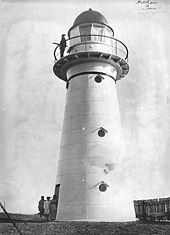
The station was established in 1883. The original lighthouse was a timber frame lighthouse covered in rolled galvanised iron sheeting, much like
1074:
397:
574:
1079:
726:
286:
79:
1053:
439:
813:
699:
669:
72:
823:
322:
314:
846:
783:
306:
941:
890:
625:
905:
895:
841:
347:
931:
803:
788:
355:
664:
961:
836:
778:
761:
377:
299:
989:
976:
946:
885:
362:
351:
335:
220:
1027:
798:
793:
773:
339:
302:. It had four floors including the gallery floor, with ladders leading from one floor to the next.
865:
1032:
1022:
1004:
880:
851:
831:
808:
431:
343:
656:
1037:
994:
956:
417:
381:
966:
951:
910:
900:
385:
999:
295:
263:
39:
400:. The site is open to the public, accessible by a gravel road, but the tower is closed.
278:
936:
915:
707:
588:
310:
259:
425:
1068:
1014:
317:
and the mainland to the south, and between some reefs and the mainland to the north.
753:
749:
602:
407:
251:
239:
61:
94:
81:
718:
255:
65:
694:
267:
247:
243:
57:
637:
201:
475:
473:
471:
469:
467:
521:
285:
277:
374:
370:
722:
242:
on Archer Point, a conical, 60-metre-high (200 ft) grassy
479:
369:
The current light source is a 35,000 cd 120
594:
United States
National Geospatial-Intelligence Agency
151:
square prism equipment room with balcony and lantern
1013:
975:
924:
873:
822:
760:
219:
207:
196:
188:
180:
175:
163:
155:
147:
139:
131:
123:
115:
110:
71:
53:
492:
490:
488:
1085:Buildings and structures in Far North Queensland
603:"Lighthouses of Australia: Far North Queensland"
266:, it was replaced in 1975 with a modern square
309:, now disused, the original light served as a
734:
8:
24:
1095:Tourist attractions in Far North Queensland
611:University of North Carolina at Chapel Hill
396:The site and the light are operated by the
766:
741:
727:
719:
366:indicate the ship is outside the channel.
38:
23:
665:"Caloundra Lighthouses (entry 602746 )"
451:
290:Plans for the original lighthouse, 1882
270:equipment room topped with a lantern.
282:The original Archer Point Light, 1917
7:
545:
398:Australian Maritime Safety Authority
167:Australian Maritime Safety Authority
496:
16:Lighthouse in Queensland, Australia
708:"List of Lighthouses - Queensland"
14:
508:
458:
1090:1975 establishments in Australia
1054:List of lighthouses in Australia
864:
693:
638:"Beach – Archer Point (north 1)"
440:List of lighthouses in Australia
424:
410:
28:
632:. Lighthouses of Australia Inc.
213:green: 17 nmi (31 km)
211:white: 17 nmi (31 km)
305:Together with a lighthouse on
1:
1075:Lighthouses completed in 1975
673:. Queensland Heritage Council
626:"The Archer Point Lighthouse"
215:red: 13 nmi (24 km)
670:Queensland Heritage Register
480:Lighthouses of Australia Inc
392:Site operation and visiting
1111:
824:Moreton Island lighthouses
323:Queensland Maritime Museum
95:15.5937528°S 145.3285639°E
1080:Lighthouses in Queensland
1046:
862:
769:
630:Lighthouses of Queensland
246:about 29km southeast of
229:
171:
49:
37:
712:Lighthouses of Australia
607:The Lighthouse Directory
262:lighthouse covered with
100:-15.5937528; 145.3285639
44:Archer Point Light, 2005
348:New Burnett Heads Light
356:Point Cartwright Light
291:
283:
526:maritimemuseum.com.au
378:Tungsten-halogen bulb
300:Flat Top Island Light
289:
281:
258:. Originally an 1883
702:at Wikimedia Commons
596:. 2009. p. 195.
363:light characteristic
352:Fitzroy Island Light
336:Cape Capricorn Light
192:213 feet (65 m)
143:19 feet (5.8 m)
847:North Point Hummock
784:Double Island Point
340:New Caloundra Light
91: /
34:
942:Cape Bowling Green
891:Lady Elliot Island
700:Archer Point Light
432:Engineering portal
344:Point Danger Light
292:
284:
236:Archer Point Light
25:Archer Point Light
1062:
1061:
906:Old Burnett Heads
896:New Burnett Heads
860:
859:
842:Cowan Cowan Point
714:. SeaSide Lights.
698:Media related to
418:Queensland portal
382:mains electricity
233:
232:
1102:
868:
804:Point Cartwright
789:Moreton Bay Pile
767:
762:South East Coast
743:
736:
729:
720:
715:
697:
682:
680:
678:
660:
652:
650:
648:
642:beachsafe.org.au
633:
621:
619:
617:
597:
585:
576:List of Lights,
560:
555:
549:
543:
537:
536:
534:
532:
518:
512:
506:
500:
494:
483:
477:
462:
456:
434:
429:
428:
420:
415:
414:
413:
386:diesel generator
106:
105:
103:
102:
101:
96:
92:
89:
88:
87:
84:
42:
35:
33:
32:
1110:
1109:
1105:
1104:
1103:
1101:
1100:
1099:
1065:
1064:
1063:
1058:
1042:
1009:
977:Far North Coast
971:
962:Flat Top Island
920:
869:
856:
837:Comboyuro Point
818:
779:Cleveland Point
756:
747:
706:Searle, Garry.
705:
690:
685:
676:
674:
663:
655:
646:
644:
636:
624:
615:
613:
601:Rowlett, Russ.
600:
583:
573:
569:
564:
563:
556:
552:
544:
540:
530:
528:
520:
519:
515:
507:
503:
495:
486:
478:
465:
457:
453:
448:
430:
423:
416:
411:
409:
406:
394:
380:, fed from the
331:
296:Low Isles Light
276:
264:galvanised iron
225:Fl (4) WRG 20s.
214:
212:
99:
97:
93:
90:
85:
82:
80:
78:
77:
64:
60:
45:
26:
22:
17:
12:
11:
5:
1108:
1106:
1098:
1097:
1092:
1087:
1082:
1077:
1067:
1066:
1060:
1059:
1057:
1056:
1051:
1047:
1044:
1043:
1041:
1040:
1035:
1030:
1025:
1019:
1017:
1011:
1010:
1008:
1007:
1002:
997:
992:
990:Fitzroy Island
987:
981:
979:
973:
972:
970:
969:
964:
959:
954:
949:
947:Cape Cleveland
944:
939:
934:
928:
926:
922:
921:
919:
918:
913:
908:
903:
898:
893:
888:
886:Cape Capricorn
883:
877:
875:
871:
870:
863:
861:
858:
857:
855:
854:
849:
844:
839:
834:
828:
826:
820:
819:
817:
816:
811:
806:
801:
796:
791:
786:
781:
776:
770:
764:
758:
757:
748:
746:
745:
738:
731:
723:
717:
716:
703:
689:
688:External links
686:
684:
683:
661:
653:
634:
622:
598:
589:List of Lights
570:
568:
565:
562:
561:
558:List of Lights
550:
538:
513:
501:
484:
463:
450:
449:
447:
444:
443:
442:
436:
435:
421:
405:
402:
393:
390:
330:
327:
275:
272:
231:
230:
227:
226:
223:
221:Characteristic
217:
216:
209:
205:
204:
198:
194:
193:
190:
186:
185:
184:1979 (current)
182:
178:
177:
173:
172:
169:
168:
165:
161:
160:
157:
153:
152:
149:
145:
144:
141:
137:
136:
133:
129:
128:
127:concrete tower
125:
121:
120:
117:
113:
112:
108:
107:
86:145°19′42.83″E
75:
69:
68:
55:
51:
50:
47:
46:
43:
20:
15:
13:
10:
9:
6:
4:
3:
2:
1107:
1096:
1093:
1091:
1088:
1086:
1083:
1081:
1078:
1076:
1073:
1072:
1070:
1055:
1052:
1049:
1048:
1045:
1039:
1036:
1034:
1031:
1029:
1028:Eborac Island
1026:
1024:
1021:
1020:
1018:
1016:
1015:Torres Strait
1012:
1006:
1003:
1001:
998:
996:
993:
991:
988:
986:
983:
982:
980:
978:
974:
968:
965:
963:
960:
958:
955:
953:
950:
948:
945:
943:
940:
938:
935:
933:
930:
929:
927:
923:
917:
914:
912:
909:
907:
904:
902:
899:
897:
894:
892:
889:
887:
884:
882:
879:
878:
876:
874:Central Coast
872:
867:
853:
850:
848:
845:
843:
840:
838:
835:
833:
830:
829:
827:
825:
821:
815:
814:Point Lookout
812:
810:
807:
805:
802:
800:
799:Old Caloundra
797:
795:
794:New Caloundra
792:
790:
787:
785:
782:
780:
777:
775:
774:Bulwer Island
772:
771:
768:
765:
763:
759:
755:
751:
744:
739:
737:
732:
730:
725:
724:
721:
713:
709:
704:
701:
696:
692:
691:
687:
672:
671:
666:
662:
658:
657:"Tower plans"
654:
643:
639:
635:
631:
627:
623:
612:
608:
604:
599:
595:
591:
590:
582:
581:
577:
572:
571:
566:
559:
554:
551:
547:
542:
539:
527:
523:
517:
514:
510:
505:
502:
498:
493:
491:
489:
485:
481:
476:
474:
472:
470:
468:
464:
460:
455:
452:
445:
441:
438:
437:
433:
427:
422:
419:
408:
403:
401:
399:
391:
389:
387:
383:
379:
376:
372:
367:
364:
359:
357:
353:
349:
345:
341:
337:
329:Current light
328:
326:
324:
318:
316:
312:
308:
303:
301:
297:
288:
280:
273:
271:
269:
265:
261:
257:
253:
249:
245:
241:
238:is an active
237:
228:
224:
222:
218:
210:
206:
203:
199:
195:
191:
187:
183:
179:
174:
170:
166:
162:
159:white lantern
158:
154:
150:
146:
142:
138:
134:
130:
126:
122:
118:
114:
109:
104:
83:15°35′37.51″S
76:
74:
70:
67:
63:
59:
56:
52:
48:
41:
36:
31:
19:
1033:Goods Island
1023:Booby Island
1005:Wharton Reef
985:Archer Point
984:
881:Bustard Head
852:Yellow Patch
832:Cape Moreton
809:Point Danger
711:
675:. Retrieved
668:
645:. Retrieved
641:
629:
614:. Retrieved
606:
587:
579:
575:
557:
553:
541:
529:. Retrieved
525:
516:
504:
454:
395:
388:for backup.
368:
360:
358:and itself.
332:
319:
315:Hope Islands
307:Rocky Island
304:
293:
260:timber frame
235:
234:
200:35,000
189:Focal height
124:Construction
119:1883 (first)
18:
1038:Wyborn Reef
995:Grassy Hill
957:Dent Island
932:Albino Rock
925:North Coast
750:Lighthouses
647:15 November
616:14 November
531:28 November
116:Constructed
98: /
73:Coordinates
1069:Categories
967:Pine Islet
952:Creal Reef
911:Sandy Cape
901:North Reef
754:Queensland
567:References
373:1000
311:lead light
252:Queensland
240:lighthouse
62:Queensland
21:Lighthouse
1000:Low Isles
578:Pub. 111:
522:"QMMAWeb"
384:, with a
256:Australia
197:Intensity
181:First lit
132:Automated
66:Australia
1050:See also
937:Bay Rock
916:Sea Hill
546:QHR31351
404:See also
313:between
268:concrete
248:Cooktown
244:headland
164:Operator
156:Markings
58:Cooktown
54:Location
677:13 July
659:. 1882.
497:Rowlett
274:History
140:Height
584:(PDF)
509:Plans
459:Beach
446:Notes
208:Range
176:Light
148:Shape
111:Tower
27:
679:2015
649:2010
618:2010
533:2010
375:Watt
371:Volt
361:The
298:and
135:1979
752:of
1071::
710:.
667:.
640:.
628:.
609:.
605:.
592:.
586:.
524:.
487:^
466:^
354:,
350:,
346:,
342:,
338:,
325:.
254:,
250:,
202:cd
742:e
735:t
728:v
681:.
651:.
620:.
548:.
535:.
511:.
499:.
482:.
461:.
Text is available under the Creative Commons Attribution-ShareAlike License. Additional terms may apply.