411:
1060:
26:
873:
1074:
1030:
785:
726:
708:
298:
283:
527:
1008:
817:
745:
669:
630:
150:
131:
99:
45:
779:
1488:
606:
83:
960:
findings exist in subsequent meeting minutes between 1978 and June 1, 1991, when the
Commission authorized the extension to Highway 219. Three months later, the Commission redesignated the highway as Highway 96 due to confusion between the two eastbound routes with junctions on Highway 23 within a few miles of each other.
453:. Along this route lies the small town of Roseville. According to local folklore Roseville missed out on being the capital of Arkansas by only one vote. Whither this is true or not has never been proven, but this story has been passed down from generation to generation and survives til this day.
959:
on March 26, 1975. The
Commission requested a study regarding extending the route east to Highway 219 on July 31, 1975, and requested an update to that study on March 22, 1978. Although the Commission requested the study's findings be reported at a later meeting, no record of the report's
1141:
1512:
481:
374:
489:
402:. This alignment does not cross any other state highways. An average daily vehicle count from 2010 indicated that 630 vehicles per day use this segment of Highway 309.
1517:
1522:
1527:
246:
1478:
477:
256:
231:
538:
A segment of 20.4 miles (32.8 km) winds from Havana north through the Ozark
National Forest to an area south of Paris. The route passes by
58:
1138:
485:
430:
251:
1507:
1424:
1398:
1087:
241:
956:
550:
available from an overlook. Many current camp sites are former home sites that were bought by the government during the depression.
236:
326:
1492:
593:
547:
442:
391:
334:
87:
1225:(Map). 1:62500. Cartography by Planning and Research Division. Arkansas State Highway and Transportation Department. 2011
1198:(Map). 1:62500. Cartography by Planning and Research Division. Arkansas State Highway and Transportation Department. 2002
1171:(Map). 1:62500. Cartography by Planning and Research Division. Arkansas State Highway and Transportation Department. 2002
1266:
1115:"Mount Magazine Scenic Byway/Highway 309." Arkansas State Highway and Transportation Department, Scenic Byways Program.
446:
1245:
1217:
1097:
973:
799:
501:
204:
1190:
1305:
1163:
952:
1292:
266:
223:
1092:
690:
461:
370:
261:
200:
951:
Highway 309 was first added to the state highway system as a 0.5 miles (0.80 km) access road to the
1116:
824:
617:
588:
426:
395:
350:
342:
196:
106:
546:'s highest point. Recreation areas include Cove Lake and Mt. Magazine Recreation Areas, with views of
1065:
1033:
936:
789:
756:
752:
729:
711:
680:
637:
469:
301:
286:
1011:
940:
820:
804:
765:
748:
672:
633:
509:
505:
473:
438:
415:
399:
358:
354:
338:
157:
153:
134:
102:
848:
715:
676:
641:
465:
410:
1469:
1079:
493:
1431:
1405:
656:
422:
346:
330:
138:
1145:
969:
932:
892:
828:
695:
450:
434:
362:
333:. One route of 5.11 miles (8.22 km) runs from Yell County Route 28 (CR 28) at
539:
531:
521:
497:
1501:
1137:" State Highways 2009 (Database)." April 2010. AHTD: Planning and Research Division.
176:
935:. The route of 1.84 miles (2.96 km) began at Highway 23 and ran east to
943:
in 1991 due to traveler confusion with the existing section of
Highway 309.
1293:
U.S. Geological Survey
Geographic Names Information System: Arkansas Highway 309
457:
1055:
526:
1487:
872:
44:
25:
543:
186:
1270:
496:
to exit town heading north. The route runs north, briefly along the
1309:
742:
705:
525:
409:
1477:
1430:. Arkansas State Highway Commission. 1990–1999. Archived from
1404:. Arkansas State Highway Commission. 1970–1979. Archived from
1295:
United States
Geological Survey. Retrieved November 22, 2011.
1269:. United States Department of Transportation. Archived from
1044:
1.000 mi = 1.609 km; 1.000 km = 0.621 mi
838:
1.000 mi = 1.609 km; 1.000 km = 0.621 mi
390:
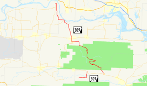
Highway 309 begins at Yell County Route 28 near
1465:
1460:
425:
at
Highway 10. The route begins north through the
421:
A second, longer routing of
Highway 309 begins in
1386:
1374:
1362:
1350:
1333:
760:
719:
398:. The route runs east and turns north to terminate at
1246:"Folkloric Relocations of the Arkansas State Capitol"
365:. A portion of the second route is designated as the
375:
Arkansas State
Highway and Transportation Department
906:
898:
888:
868:
214:
192:
182:
172:
167:
144:
125:
117:
112:
93:
77:
69:
64:
51:
21:
445:near Cove Lake. The highway also passes over the
345:. A second segment begins at Highway 10 in
1219:General Highway Map, Franklin County, Arkansas
8:
488:. Highway 309 continues north past the
1513:Transportation in Franklin County, Arkansas
1192:General Highway Map, Logan County, Arkansas
1479:Template:Attached KML/Arkansas Highway 309
1165:General Highway Map, Yell County, Arkansas
978:
732:concurrency north, 1.0 mile (1.6 km)
560:
449:prior to exiting the forest northbound to
275:
1482:
1346:
1344:
1342:
1329:
1327:
1518:Transportation in Logan County, Arkansas
16:State highway in Arkansas, United States
1523:Transportation in Yell County, Arkansas
1108:
865:
542:, which at 2,753 feet (839 m) is
18:
1158:
1156:
1154:
1027:
1021:
1005:
999:
814:
808:
775:
769:
736:
699:
666:
660:
627:
621:
603:
597:
558:Mile markers reset at concurrencies.
504:. The route runs almost due north to
7:
1133:
1131:
1129:
1127:
1125:
486:National Register of Historic Places
472:in south Paris, continuing north to
1308:. February 28, 2006. Archived from
1088:List of state highways in Arkansas
987:
575:
482:Paris Commercial Historic District
121:42.90 mi (69.04 km)
14:
1528:Ozark–St. Francis National Forest
957:Arkansas State Highway Commission
910:March 26, 1975–September 25, 1991
1486:
1072:
1058:
1028:
1006:
902:1.84 mi (2.96 km)
871:
815:
783:
777:
743:
724:
706:
667:
628:
604:
530:View facing northeast from atop
349:and winds northwest through the
296:
281:
148:
129:
97:
81:
73:5.11 mi (8.22 km)
43:
24:
476:. This junction also contains
386:Blue Mountain Lake to Waveland
1:
1306:"Mount Magazine Scenic Byway"
1267:"Mount Magazine Scenic Byway"
982:
570:
443:Cove Lake Spillway Dam-Bridge
516:Mount Magazine Scenic Byway
456:Upon entering the northern
447:Cove Creek Tributary Bridge
367:Mount Magazine Scenic Byway
325:) is a designation for two
38:Mount Magazine Scenic Byway
1544:
1508:State highways in Arkansas
519:
490:Methodist Episcopal Church
429:. The route runs near the
1098:Mount Magazine State Park
1043:
1038:
1024:
1016:
1002:
994:
991:
986:
981:
939:. It was redesignated as
884:
837:
832:
811:
803:
798:
794:
772:
764:
739:
723:
702:
694:
689:
684:
663:
655:
650:
645:
624:
616:
611:
600:
592:
587:
582:
579:
574:
569:
566:
563:
508:, where it terminates at
464:Highway 309 forms a
274:
219:
210:
163:
56:
42:
37:
1425:"Minutes of the Meeting"
1399:"Minutes of the Meeting"
1148:Retrieved April 3, 2011.
968:The entire route was in
844:
1119:Retrieved July 8, 2011.
953:Ozark Municipal Airport
931:) is a former route in
478:Logan County Courthouse
224:Arkansas Highway System
1093:Arkansas Scenic Byways
535:
418:
371:Arkansas Scenic Byways
1495:at Wikimedia Commons
1291:"Magazine Mountain."
529:
427:Ozark National Forest
413:
351:Ozark National Forest
1493:Arkansas Highway 309
1483:KML is from Wikidata
1066:United States portal
414:Highway 309 at
315:Arkansas Highway 309
1411:on November 5, 2011
1387:"Minutes" (1990–99)
1375:"Minutes" (1970–79)
1363:"Minutes" (1970–79)
1351:"Minutes" (1990–99)
1334:"Minutes" (1970–79)
1312:on November 7, 2011
964:Major intersections
554:Major intersections
439:Cove Lake Bathhouse
406:Havana to Webb City
1144:2011-07-07 at the
594:Blue Mountain Lake
548:Blue Mountain Lake
536:
419:
392:Blue Mountain Lake
373:maintained by the
335:Blue Mountain Lake
88:Blue Mountain Lake
1491:Media related to
1273:on March 20, 2007
1080:U.S. Roads portal
1049:
1048:
1039:Northern terminus
1017:Southern terminus
914:
913:
859:
858:
500:before it enters
494:Paris Post Office
431:Cove Creek Bridge
381:Route description
312:
311:
308:
307:
52:Route information
1535:
1490:
1473:
1446:
1444:
1442:
1437:on July 21, 2019
1436:
1429:
1420:
1418:
1416:
1410:
1403:
1390:
1384:
1378:
1372:
1366:
1360:
1354:
1348:
1337:
1331:
1322:
1321:
1319:
1317:
1302:
1296:
1289:
1283:
1282:
1280:
1278:
1263:
1257:
1256:
1254:
1252:
1244:Lancaster, Guy.
1241:
1235:
1234:
1232:
1230:
1224:
1214:
1208:
1207:
1205:
1203:
1197:
1187:
1181:
1180:
1178:
1176:
1170:
1160:
1149:
1135:
1120:
1113:
1082:
1077:
1076:
1075:
1068:
1063:
1062:
1061:
1032:
1031:
1010:
1009:
989:
984:
979:
937:Highway 219
875:
866:
852:
845:
833:Eastern terminus
819:
818:
788:
787:
786:
781:
780:
747:
746:
728:
727:
710:
709:
685:Western terminus
671:
670:
646:Eastern terminus
632:
631:
612:Western terminus
608:
607:
577:
572:
561:
369:, one of eleven
331:Western Arkansas
304:
300:
299:
289:
285:
284:
276:
152:
151:
133:
132:
101:
100:
85:
84:
47:
28:
19:
1543:
1542:
1538:
1537:
1536:
1534:
1533:
1532:
1498:
1497:
1484:
1481:
1476:
1475:
1474:
1458:
1454:
1449:
1440:
1438:
1434:
1427:
1423:
1414:
1412:
1408:
1401:
1397:
1393:
1385:
1381:
1373:
1369:
1361:
1357:
1349:
1340:
1332:
1325:
1315:
1313:
1304:
1303:
1299:
1290:
1286:
1276:
1274:
1265:
1264:
1260:
1250:
1248:
1243:
1242:
1238:
1228:
1226:
1222:
1216:
1215:
1211:
1201:
1199:
1195:
1189:
1188:
1184:
1174:
1172:
1168:
1162:
1161:
1152:
1146:Wayback Machine
1136:
1123:
1114:
1110:
1106:
1078:
1073:
1071:
1064:
1059:
1057:
1054:
1045:
1029:
1007:
974:Franklin County
966:
949:
941:Highway 96
880:
879:
876:
864:
855:
847:
843:
839:
816:
784:
782:
778:
776:
744:
725:
707:
668:
629:
605:
556:
524:
518:
502:Franklin County
435:Burnett Springs
408:
388:
383:
297:
295:
282:
280:
149:
130:
98:
82:
33:
32:
29:
17:
12:
11:
5:
1541:
1539:
1531:
1530:
1525:
1520:
1515:
1510:
1500:
1499:
1457:
1456:
1455:
1453:
1452:External links
1450:
1448:
1447:
1421:
1394:
1392:
1391:
1389:, p. 142.
1379:
1377:, p. 249.
1367:
1365:, p. 874.
1355:
1353:, p. 173.
1338:
1336:, p. 789.
1323:
1297:
1284:
1258:
1236:
1209:
1182:
1150:
1121:
1107:
1105:
1102:
1101:
1100:
1095:
1090:
1084:
1083:
1069:
1053:
1050:
1047:
1046:
1041:
1040:
1037:
1026:
1023:
1019:
1018:
1015:
1004:
1001:
997:
996:
993:
990:
985:
965:
962:
948:
945:
912:
911:
908:
904:
903:
900:
896:
895:
890:
886:
885:
882:
881:
877:
870:
869:
863:
860:
857:
856:
854:
853:
840:
835:
834:
831:
813:
810:
807:
802:
796:
795:
793:
774:
771:
768:
762:
761:
759:
741:
738:
734:
733:
721:
720:
718:
704:
701:
698:
693:
687:
686:
683:
665:
662:
659:
653:
652:
648:
647:
644:
626:
623:
620:
614:
613:
610:
602:
599:
596:
591:
585:
584:
581:
578:
573:
568:
565:
555:
552:
540:Mount Magazine
532:Mount Magazine
522:Mount Magazine
517:
514:
498:Arkansas River
407:
404:
387:
384:
382:
379:
327:state highways
310:
309:
306:
305:
292:
290:
272:
271:
270:
269:
264:
259:
254:
249:
244:
239:
234:
228:
227:
217:
216:
215:Highway system
212:
211:
208:
207:
194:
190:
189:
184:
180:
179:
174:
170:
169:
165:
164:
161:
160:
146:
142:
141:
127:
123:
122:
119:
115:
114:
110:
109:
95:
91:
90:
79:
75:
74:
71:
67:
66:
62:
61:
57:Maintained by
54:
53:
49:
48:
40:
39:
35:
34:
30:
23:
22:
15:
13:
10:
9:
6:
4:
3:
2:
1540:
1529:
1526:
1524:
1521:
1519:
1516:
1514:
1511:
1509:
1506:
1505:
1503:
1496:
1494:
1489:
1480:
1471:
1467:
1463:
1462:
1451:
1433:
1426:
1422:
1407:
1400:
1396:
1395:
1388:
1383:
1380:
1376:
1371:
1368:
1364:
1359:
1356:
1352:
1347:
1345:
1343:
1339:
1335:
1330:
1328:
1324:
1311:
1307:
1301:
1298:
1294:
1288:
1285:
1272:
1268:
1262:
1259:
1247:
1240:
1237:
1221:
1220:
1213:
1210:
1194:
1193:
1186:
1183:
1167:
1166:
1159:
1157:
1155:
1151:
1147:
1143:
1140:
1134:
1132:
1130:
1128:
1126:
1122:
1118:
1112:
1109:
1103:
1099:
1096:
1094:
1091:
1089:
1086:
1085:
1081:
1070:
1067:
1056:
1051:
1042:
1035:
1020:
1013:
998:
980:
977:
975:
971:
963:
961:
958:
954:
946:
944:
942:
938:
934:
930:
926:
922:
918:
909:
905:
901:
897:
894:
891:
887:
883:
874:
867:
861:
850:
842:
841:
836:
830:
826:
822:
806:
801:
797:
791:
767:
763:
758:
754:
750:
735:
731:
722:
717:
713:
697:
692:
688:
682:
678:
674:
658:
654:
651:Gap in route
649:
643:
639:
635:
619:
615:
595:
590:
586:
562:
559:
553:
551:
549:
545:
541:
533:
528:
523:
515:
513:
511:
507:
503:
499:
495:
491:
487:
483:
479:
475:
471:
467:
463:
459:
454:
452:
448:
444:
440:
436:
432:
428:
424:
417:
412:
405:
403:
401:
397:
393:
385:
380:
378:
376:
372:
368:
364:
360:
356:
352:
348:
344:
340:
337:northeast to
336:
332:
328:
324:
320:
316:
303:
293:
291:
288:
278:
277:
273:
268:
265:
263:
260:
258:
255:
253:
250:
248:
245:
243:
240:
238:
235:
233:
230:
229:
226:
225:
221:
220:
218:
213:
209:
206:
202:
198:
195:
191:
188:
185:
181:
178:
177:United States
175:
171:
166:
162:
159:
155:
147:
145:East end
143:
140:
136:
128:
126:West end
124:
120:
116:
111:
108:
104:
96:
94:East end
92:
89:
80:
78:West end
76:
72:
68:
63:
60:
55:
50:
46:
41:
36:
27:
20:
1485:
1459:
1441:November 22,
1439:. Retrieved
1432:the original
1415:November 22,
1413:. Retrieved
1406:the original
1382:
1370:
1358:
1316:November 22,
1314:. Retrieved
1310:the original
1300:
1287:
1277:November 22,
1275:. Retrieved
1271:the original
1261:
1249:. Retrieved
1239:
1229:November 22,
1227:. Retrieved
1218:
1212:
1202:November 22,
1200:. Retrieved
1191:
1185:
1175:November 22,
1173:. Retrieved
1164:
1111:
992:Destinations
967:
950:
928:
924:
920:
916:
915:
862:Former route
846:
580:Destinations
557:
537:
462:Logan County
455:
420:
389:
366:
322:
318:
314:
313:
222:
1034:AR 219
917:Highway 309
878:Highway 309
849:Concurrency
825:Caulksville
790:AR 288
730:AR 109
712:AR 109
470:Highway 109
466:concurrency
458:county seat
396:Yell County
302:AR 310
287:AR 308
31:Highway 309
1502:Categories
1104:References
1012:AR 23
821:AR 23
757:Fort Smith
753:Charleston
749:AR 22
681:Booneville
673:AR 10
638:Booneville
634:AR 10
520:See also:
510:Highway 23
474:Highway 22
437:, and the
400:Highway 10
355:Highway 23
339:Highway 10
232:Interstate
154:AR 23
135:AR 10
103:AR 10
1139:Database.
1014:(18th St)
805:Webb City
766:Roseville
506:Webb City
416:Webb City
359:Webb City
158:Webb City
113:Section 2
86:CR 28 at
65:Section 1
1461:KML file
1251:7 August
1142:Archived
1052:See also
1036:(3rd St)
929:Hwy. 309
925:Ark. 309
889:Location
851:terminus
823: –
800:Franklin
751: –
716:Magazine
714: –
677:Danville
675: –
642:Danville
636: –
618:Waveland
567:Location
544:Arkansas
480:and the
377:(AHTD).
343:Waveland
323:Hwy. 309
267:Heritage
257:Suffixed
247:Business
205:Franklin
193:Counties
187:Arkansas
168:Location
107:Waveland
955:by the
947:History
907:Existed
484:on the
173:Country
927:, and
921:AR 309
899:Length
657:Havana
564:County
492:, and
423:Havana
347:Havana
319:AR 309
262:Scenic
139:Havana
118:Length
70:Length
1435:(PDF)
1428:(PDF)
1409:(PDF)
1402:(PDF)
1223:(PDF)
1196:(PDF)
1169:(PDF)
995:Notes
970:Ozark
933:Ozark
893:Ozark
829:Ozark
812:25.70
809:15.97
773:11.96
703:43.34
700:26.93
696:Paris
691:Logan
609:CR 28
583:Notes
468:with
451:Paris
363:Paris
252:Spurs
242:State
201:Logan
183:State
59:ArDOT
1470:help
1466:edit
1443:2016
1417:2016
1318:2011
1279:2011
1253:2012
1231:2011
1204:2011
1177:2011
1117:Link
1025:2.96
1022:1.84
1003:0.00
1000:0.00
792:west
770:7.43
740:0.00
737:0.00
664:0.00
661:0.00
625:8.22
622:5.11
601:0.00
598:0.00
589:Yell
441:and
361:via
321:and
197:Yell
460:of
394:in
357:at
353:to
341:at
329:in
156:at
137:at
105:at
1504::
1468:•
1341:^
1326:^
1153:^
1124:^
988:km
983:mi
976:.
972:,
923:,
827:,
755:,
679:,
640:,
576:km
571:mi
512:.
433:,
294:→
279:←
237:US
203:,
199:,
1472:)
1464:(
1445:.
1419:.
1320:.
1281:.
1255:.
1233:.
1206:.
1179:.
919:(
534:.
317:(
Text is available under the Creative Commons Attribution-ShareAlike License. Additional terms may apply.