282:
26:
586:
135:
424:
548:
510:
404:
398:
265:
250:
93:
592:
554:
516:
417:
411:
141:
88:
686:
477:
118:
430:
344:
The route between
Florence and Coolidge was numbered as SR 287 in 1932. At that time, it was an unpaved road. By 1934, it was paved in the segment it was designated. In 1961, the section to Casa Grande was added to the designation.
846:
604:
817:
213:
228:
665:
51:
841:
600:
218:
596:
223:
145:
233:
851:
300:. Originally, this highway number only applied to Florence-Coolidge Highway; the branch to Casa Grande was added later.
719:
658:
329:
480:
333:
321:
121:
434:
268:
253:
100:
558:
520:
461:
459:
Western terminus of SR 287; southern terminus of SR 387; eastern terminus of SR 84; SR 387 is former
438:
313:
96:
454:
354:
188:
384:
325:
104:
625:
450:
281:
808:
572:
534:
317:
309:
149:
524:
484:
446:
324:
as
Arizona Boulevard, and travels several miles directly south until diverging westward to
488:
55:
657:
Roadway
Inventory Management Section, Multimodal Planning Division (December 31, 2021).
835:
562:
328:(where it is known as Florence Boulevard). It terminates there at its junction with
168:
771:
442:
713:
691:
765:
741:
826:
320:
as the
Florence-Coolidge Highway. Upon reaching Coolidge, SR 287 overlaps
25:
297:
178:
816:
544:
506:
280:
316:
near the southern end of town. The route proceeds westbound to
296:, is a predominantly east–west state highway in central
615:
1.000 mi = 1.609 km; 1.000 km = 0.621 mi
285:
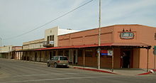
SR 287, the
Florence-Coolidge Highway, in downtown Florence.
804:
799:
566:
528:
198:
184:
174:
164:
159:
128:
110:
82:
77:
69:
61:
44:
21:
652:
650:
648:
818:Template:Attached KML/Arizona State Route 287
746:(Map). Arizona State Highway Department. 1934
8:
359:
242:
821:
774:. Arizona State Highway Department. 1963
847:Transportation in Pinal County, Arizona
644:
16:State highway in Arizona, United States
18:
743:Condition Map of State Highway System
715:Condition Map of State Highway System
582:
576:
538:
500:
474:
468:
394:
388:
7:
666:Arizona Department of Transportation
371:
65:30.69 mi (49.39 km)
14:
590:
584:
552:
546:
514:
508:
475:
428:
422:
415:
409:
402:
396:
263:
248:
139:
133:
116:
91:
86:
24:
659:"2021 State Highway System Log"
39:SR 287 highlighted in red
1:
567:East end of SR 87 concurrency
529:West end of SR 87 concurrency
366:
441:west (Gila Bend Highway) to
437:north (Pinal Avenue) /
207:Arizona State Highway System
868:
720:Arizona Highway Department
605:Florence Historic District
842:State highways in Arizona
614:
609:
579:
571:
541:
533:
503:
497:
492:
471:
458:
391:
383:
378:
375:
370:
365:
362:
241:
203:
194:
155:
49:
37:
687:"overview map of SR 287"
621:
827:SR 287 at Arizona Roads
353:The entire route is in
312:at a "Y" junction with
770:(Map). Cartography by
286:
284:
852:Casa Grande, Arizona
822:KML is from Wikidata
767:Road Map of Arizona
607:, Business District
601:Historic US 80
314:SR 79 Business
112:Major intersections
56:City of Casa Grande
287:
636:
635:
308:SR 287 begins in
304:Route description
279:
278:
275:
274:
45:Route information
859:
812:
784:
783:
781:
779:
762:
756:
755:
753:
751:
738:
732:
731:
729:
727:
710:
704:
703:
701:
699:
683:
677:
676:
674:
672:
663:
654:
629:
622:
610:Eastern terminus
595:
594:
593:
588:
587:
557:
556:
555:
550:
549:
519:
518:
517:
512:
511:
479:
478:
464:
433:
432:
431:
426:
425:
420:
419:
418:
413:
412:
407:
406:
405:
400:
399:
373:
368:
360:
292:, also known as
271:
267:
266:
256:
252:
251:
243:
144:
143:
142:
137:
136:
120:
119:
113:
95:
94:
90:
89:
28:
19:
867:
866:
862:
861:
860:
858:
857:
856:
832:
831:
823:
820:
815:
814:
813:
797:
793:
788:
787:
777:
775:
764:
763:
759:
749:
747:
740:
739:
735:
725:
723:
712:
711:
707:
697:
695:
685:
684:
680:
670:
668:
661:
656:
655:
646:
641:
632:
624:
620:
616:
597:SR 79 Bus.
591:
589:
585:
583:
553:
551:
547:
545:
515:
513:
509:
507:
476:
460:
429:
427:
423:
421:
416:
414:
410:
408:
403:
401:
397:
395:
351:
342:
330:State Route 387
306:
290:State Route 287
264:
262:
249:
247:
146:SR 79 Bus.
140:
138:
134:
132:
117:
111:
92:
87:
78:Major junctions
40:
33:
32:
31:State Route 287
29:
17:
12:
11:
5:
865:
863:
855:
854:
849:
844:
834:
833:
830:
829:
796:
795:
794:
792:
791:External links
789:
786:
785:
757:
733:
705:
678:
643:
642:
640:
637:
634:
633:
631:
630:
617:
612:
611:
608:
581:
578:
575:
569:
568:
565:
543:
540:
537:
531:
530:
527:
505:
502:
499:
495:
494:
491:
473:
470:
466:
465:
457:
393:
390:
387:
381:
380:
377:
374:
369:
364:
350:
347:
341:
338:
334:State Route 84
322:State Route 87
305:
302:
277:
276:
273:
272:
259:
257:
239:
238:
237:
236:
231:
226:
221:
216:
210:
209:
201:
200:
199:Highway system
196:
195:
192:
191:
186:
182:
181:
176:
172:
171:
166:
162:
161:
157:
156:
153:
152:
130:
126:
125:
124:in Casa Grande
114:
108:
107:
84:
80:
79:
75:
74:
71:
67:
66:
63:
59:
58:
50:Maintained by
47:
46:
42:
41:
38:
35:
34:
30:
23:
22:
15:
13:
10:
9:
6:
4:
3:
2:
864:
853:
850:
848:
845:
843:
840:
839:
837:
828:
825:
824:
819:
810:
806:
802:
801:
790:
773:
769:
768:
761:
758:
745:
744:
737:
734:
721:
717:
716:
709:
706:
694:
693:
688:
682:
679:
667:
660:
653:
651:
649:
645:
638:
627:
619:
618:
613:
606:
602:
598:
574:
570:
564:
561:north –
560:
536:
532:
526:
523:south –
522:
496:
493:I-10 exit 194
490:
486:
482:
467:
463:
456:
452:
448:
444:
440:
436:
386:
382:
361:
358:
356:
349:Junction list
348:
346:
339:
337:
335:
331:
327:
323:
319:
315:
311:
303:
301:
299:
295:
291:
283:
270:
260:
258:
255:
245:
244:
240:
235:
232:
230:
227:
225:
222:
220:
217:
215:
212:
211:
208:
205:
204:
202:
197:
193:
190:
187:
183:
180:
177:
173:
170:
169:United States
167:
163:
158:
154:
151:
147:
131:
129:East end
127:
123:
115:
109:
106:
102:
98:
85:
83:West end
81:
76:
72:
68:
64:
60:
57:
53:
48:
43:
36:
27:
20:
798:
776:. Retrieved
772:Rand McNally
766:
760:
748:. Retrieved
742:
736:
724:. Retrieved
714:
708:
696:. Retrieved
690:
681:
669:. Retrieved
623:
376:Destinations
355:Pinal County
352:
343:
307:
293:
289:
288:
206:
73:1932–present
692:Google Maps
626:Concurrency
435:SR 387
385:Casa Grande
326:Casa Grande
269:SR 288
254:SR 286
105:Casa Grande
101:SR 387
836:Categories
639:References
559:SR 87
521:SR 87
462:SR 93
439:SR 84
214:Interstate
97:SR 84
778:March 30,
750:March 30,
726:March 30,
603:) –
455:San Diego
451:Gila Bend
800:KML file
628:terminus
573:Florence
535:Coolidge
483: –
445: –
363:Location
318:Coolidge
310:Florence
229:Proposed
185:Counties
160:Location
150:Florence
99: /
718:(Map).
698:June 5,
689:(Map).
671:June 5,
525:Picacho
498:
485:Phoenix
447:Phoenix
340:History
298:Arizona
179:Arizona
165:Country
70:Existed
722:. 1932
489:Tucson
294:SR 287
234:Former
62:Length
662:(PDF)
580:49.39
577:30.69
542:36.47
539:22.66
504:22.66
501:14.08
379:Notes
224:State
189:Pinal
175:State
809:help
805:edit
780:2012
752:2012
728:2012
700:2023
673:2023
563:Mesa
481:I-10
472:6.57
469:4.08
392:0.00
389:0.00
332:and
122:I-10
52:ADOT
443:I-8
148:in
103:in
838::
807:•
664:.
647:^
487:,
453:,
449:,
372:km
367:mi
357:.
336:.
261:→
246:←
219:US
54:,
811:)
803:(
782:.
754:.
730:.
702:.
675:.
599:(
Text is available under the Creative Commons Attribution-ShareAlike License. Additional terms may apply.