47:
345:
at an elevation of 765 feet (233 m). Isabel Creek begins at about 2,600 feet (790 m), about one mile (1.6 km) south of Mt. Helen, then flows north through the Isabel Valley, then east and north of Mt. Isabel and Mt. Hamilton until it is joined by Smith Creek. Arroyo Hondo joins
437:
in 1898 in Arroyo Hondo and Isabel creeks, but not by
Scoppettone and Smith in 1978, or by Leidy and Bronwen in 2013, and their status in the creek remains uncertain as is true of most of their former sites in the central coast.
382:), which several conservation organizations have attempted to protect. Impassable falls are now present on upper Arroyo Hondo, but the rainbow trout in its Smith and Isabel creek tributaries are assumed to be native, as
668:
Notes on the fishes of the streams flowing into San
Francisco Bay, California in Report of the Commissioner of Fisheries to the Secretary of Commerce and Labor for the fiscal year ending June 30, 1904
587:
317:
climbed the peak on August 26, 1861, they did not know it had a name, and christened it Mt. Hamilton, although they did correctly place Isabel Valley on their map to the east. When in 1895, the
465:
799:
407:
334:
275:
112:
594:
774:
321:
realized that the peak two miles (3.2 km) southeast of Mt. Hamilton was as tall (4,193 feet; 1,278 m), they correctly named it Mt. Isabel.
200:
784:
644:
804:
746:
691:
Historical
Distribution and Current Status of Steelhead/Rainbow Trout (Oncorhynchus mykiss) in Streams of the San Francisco Estuary, California
809:
130:
547:
318:
399:
255:
247:
92:
28:
314:
271:
182:
537:
441:
338:
283:
697:
508:
449:
359:
779:
571:
524:
493:
17:
666:
259:
434:
411:
341:
at an elevation of 1,585 feet (483 m) above sea level. It flows northerly to its confluence with
310:
251:
351:
342:
267:
186:
27:
This article is about Arroyo Hondo in Santa Clara County. For other creeks with the same name, see
46:
722:
620:
543:
363:
258:
and is closed to public access because of its usage as drinking water. Bounded to the east by
52:
525:
U.S. Geological Survey
Geographic Names Information System: Arroyo Hondo (Santa Clara County)
309:, and the highest point was then referred to as Mount Isabel instead of Mount Hamilton. When
383:
298:
512:
418:
403:
347:
793:
426:
375:
355:
263:
72:
56:
504:
U.S. Geological Survey. National
Hydrography Dataset high-resolution flowline data.
330:
302:
279:
116:
176:
539:
California Place Names: The Origin and
Etymology of Current Geographical Names
415:
391:
82:
215:
202:
145:
132:
775:
San
Francisco Water Department's page on trout conservation in Arroyo Hondo
305:
tributary is significant in that the
Spanish name for Mt. Hamilton was the
690:
505:
696:(Report). Center for Ecosystem Management and Restoration. p. 123.
572:
U.S. Geological Survey
Geographic Names Information System: Isabel Creek
494:
U.S. Geological Survey
Geographic Names Information System: Arroyo Hondo
456:) are present in Upper Alameda, Arroyo Hondo, Smith, and Isabel creeks.
723:
Steelhead and Other Fish Resources of Western Mt. Hamilton Streams
621:
Steelhead and Other Fish Resources of Western Mt. Hamilton Streams
665:
John Otterbein Snyder, United States Bureau of Fisheries (1905).
780:
California Creekin's account of Arroyo Hondo's restricted access
246:
is a northwestward-flowing 13-mile-long (20.9 km) river in
747:
Alameda Creek Watershed Historical Ecology Study (Table 8.4)
728:(Report). San Jose, California: San Jose State University
626:(Report). San Jose, California: San Jose State University
329:
The Arroyo Hondo mainstem is formed by the confluence of
689:
Robert A. Leidy; Gordon Becker; Brett N. Harvey (2005).
647:. California Academy of Sciences Ichthyology Collection
752:(Report). San Francisco Estuary Institute (SFEI). 2013
671:. Vol. 30. General Printing Office. p. 337
593:(Report). San Jose State University. Archived from
231:
192:
175:
161:
122:
107:
98:
88:
78:
68:
63:
39:
466:List of watercourses in the San Francisco Bay Area
398:) are also present above and below the falls. The
542:. University of California Press. p. 179.
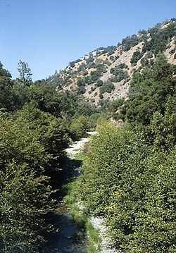
51:Summer low flows in Arroyo Hondo with riparian
406:specimen in 1898 on Isabel Creek. Also, both
18:Arroyo Hondo (Santa Clara County, California)
8:
354:. Calaveras Creek is, in turn, tributary to
588:Northern Santa Clara County Fish Resources
410:and Arroyo Hondo were recorded in 1905 by
374:Arroyo Hondo still has remnants of native
800:Rivers of Santa Clara County, California
581:
579:
567:
565:
282:which drain the west and east slopes of
536:Erwin G. Gudde; William Bright (2004).
477:
489:
487:
485:
483:
481:
36:
254:. The area is privately owned by the
7:
396:Catostomus occidentalis occidentalis
274:. It is formed by the confluence of
250:, United States, that lies east of
34:River in California, United States
25:
703:from the original on 25 July 2011
645:"Oncorhynchus mykiss gairdnerii"
586:Jerry J. Smith (July 25, 2013).
266:, Arroyo Hondo empties into the
45:
785:History of Calaveras Reservoir
400:California Academy of Sciences
256:San Francisco Water Department
248:Santa Clara County, California
194: • coordinates
124: • coordinates
1:
805:Rivers of Northern California
99:Physical characteristics
810:Tributaries of Alameda Creek
442:Foothill yellow-legged frogs
233: • elevation
163: • elevation
450:California red-legged frogs
423:Oncorhynchus mykiss irideus
380:Oncorhynchus mykiss irideus
339:Joseph D. Grant County Park
313:and Charles Hoffman of the
826:
362:and ultimately flows into
167:1,585 ft (483 m)
26:
515:, accessed March 15, 2011
388:Hesperoleucus symmetricus
171:
103:
44:
237:771 ft (235 m)
721:Jerry J. Smith (1998).
619:Jerry J. Smith (1998).
337:at the northern tip of
307:Sierra de Santa Isabel
297:means "deep creek" in
216:37.46417°N 121.77667°W
146:37.38333°N 121.69278°W
435:John Otterbein Snyder
412:John Otterbein Snyder
376:coastal rainbow trout
433:) were collected by
311:William Henry Brewer
221:37.46417; -121.77667
151:37.38333; -121.69278
431:Rhinichthys osculus
352:Calaveras Reservoir
343:Calaveras Reservoir
268:Calaveras Reservoir
262:and to the west by
212: /
187:Calaveras Reservoir
142: /
511:2012-03-29 at the
93:Santa Clara County
600:on April 11, 2016
392:Sacramento sucker
364:San Francisco Bay
241:
240:
16:(Redirected from
817:
762:
761:
759:
757:
751:
743:
737:
736:
734:
733:
727:
718:
712:
711:
709:
708:
702:
695:
686:
680:
679:
677:
676:
662:
656:
655:
653:
652:
641:
635:
634:
632:
631:
625:
616:
610:
609:
607:
605:
599:
592:
583:
574:
569:
560:
559:
557:
556:
533:
527:
522:
516:
506:The National Map
502:
496:
491:
384:California roach
286:, respectively.
227:
226:
224:
223:
222:
217:
213:
210:
209:
208:
205:
164:
157:
156:
154:
153:
152:
147:
143:
140:
139:
138:
135:
125:
49:
37:
21:
825:
824:
820:
819:
818:
816:
815:
814:
790:
789:
771:
766:
765:
755:
753:
749:
745:
744:
740:
731:
729:
725:
720:
719:
715:
706:
704:
700:
693:
688:
687:
683:
674:
672:
664:
663:
659:
650:
648:
643:
642:
638:
629:
627:
623:
618:
617:
613:
603:
601:
597:
590:
585:
584:
577:
570:
563:
554:
552:
550:
535:
534:
530:
523:
519:
513:Wayback Machine
503:
499:
492:
479:
474:
462:
419:steelhead trout
404:steelhead trout
372:
348:Calaveras Creek
327:
292:
272:Calaveras Creek
270:where it joins
234:
220:
218:
214:
211:
206:
203:
201:
199:
198:
195:
183:Calaveras Creek
162:
150:
148:
144:
141:
136:
133:
131:
129:
128:
123:
59:
35:
32:
23:
22:
15:
12:
11:
5:
823:
821:
813:
812:
807:
802:
792:
791:
788:
787:
782:
777:
770:
769:External links
767:
764:
763:
738:
713:
681:
657:
636:
611:
575:
561:
548:
528:
517:
497:
476:
475:
473:
470:
469:
468:
461:
458:
371:
368:
360:Alameda County
326:
323:
315:Whitney Survey
291:
288:
284:Mount Hamilton
239:
238:
235:
232:
229:
228:
196:
193:
190:
189:
179:
173:
172:
169:
168:
165:
159:
158:
126:
120:
119:
111:Confluence of
109:
105:
104:
101:
100:
96:
95:
90:
86:
85:
80:
76:
75:
70:
66:
65:
61:
60:
50:
42:
41:
33:
24:
14:
13:
10:
9:
6:
4:
3:
2:
822:
811:
808:
806:
803:
801:
798:
797:
795:
786:
783:
781:
778:
776:
773:
772:
768:
748:
742:
739:
724:
717:
714:
699:
692:
685:
682:
670:
669:
661:
658:
646:
640:
637:
622:
615:
612:
596:
589:
582:
580:
576:
573:
568:
566:
562:
551:
549:9780520242173
545:
541:
540:
532:
529:
526:
521:
518:
514:
510:
507:
501:
498:
495:
490:
488:
486:
484:
482:
478:
471:
467:
464:
463:
459:
457:
455:
454:Rana draytoni
451:
447:
443:
439:
436:
432:
428:
427:Speckled dace
424:
420:
417:
413:
409:
405:
401:
397:
393:
389:
385:
381:
377:
369:
367:
365:
361:
357:
356:Alameda Creek
353:
349:
344:
340:
336:
332:
324:
322:
320:
316:
312:
308:
304:
300:
296:
289:
287:
285:
281:
277:
273:
269:
265:
264:Poverty Ridge
261:
257:
253:
249:
245:
236:
230:
225:
197:
191:
188:
184:
180:
178:
174:
170:
166:
160:
155:
127:
121:
118:
114:
110:
106:
102:
97:
94:
91:
87:
84:
81:
77:
74:
73:United States
71:
67:
62:
58:
57:foothill pine
54:
48:
43:
38:
30:
19:
754:. Retrieved
741:
730:. Retrieved
716:
705:. Retrieved
684:
673:. Retrieved
667:
660:
649:. Retrieved
639:
628:. Retrieved
614:
602:. Retrieved
595:the original
553:. Retrieved
538:
531:
520:
500:
453:
445:
440:
430:
422:
402:collected a
395:
387:
379:
373:
331:Isabel Creek
328:
306:
303:Isabel Creek
295:Arroyo Hondo
294:
293:
280:Isabel Creek
244:Arroyo Hondo
243:
242:
117:Isabel Creek
40:Arroyo Hondo
29:Arroyo Hondo
446:Rana boylei
425:) streams.
408:Smith Creek
335:Smith Creek
276:Smith Creek
219: /
207:121°46′36″W
149: /
137:121°41′34″W
113:Smith Creek
53:white alder
794:Categories
732:2016-03-04
707:2011-08-28
675:2011-08-28
651:2010-11-19
630:2016-03-04
555:2010-11-21
472:References
416:anadromous
204:37°27′51″N
134:37°23′00″N
83:California
756:March 12,
604:March 12,
325:Watershed
260:Oak Ridge
698:Archived
509:Archived
460:See also
252:Milpitas
64:Location
370:Ecology
299:Spanish
290:History
69:Country
546:
448:) and
390:) and
301:. Its
181:Joins
108:Source
89:Region
750:(PDF)
726:(PDF)
701:(PDF)
694:(PDF)
624:(PDF)
598:(PDF)
591:(PDF)
177:Mouth
79:State
758:2016
606:2016
544:ISBN
333:and
319:USGS
278:and
115:and
55:and
414:as
358:in
350:in
185:in
796::
578:^
564:^
480:^
366:.
760:.
735:.
710:.
678:.
654:.
633:.
608:.
558:.
452:(
444:(
429:(
421:(
394:(
386:(
378:(
31:.
20:)
Text is available under the Creative Commons Attribution-ShareAlike License. Additional terms may apply.