60:
36:
1189:
67:
513:
climate of east Nepal. The landscape south of the border tends to be steep with less than 15 percent of the area having a sustained slope of less than 15° and is strongly dissected by stream channels. Many of the hill slopes are structurally unstable, and the region is seismically active. The August
497:
The Arun is the largest trans-Himalayan river passing through Nepal and also has the greatest snow and ice-covered area of any
Nepalese river basin. The Arun drains more than half of the area contributing to the Sapta Kosi river system but provides only about a quarter of the total discharge. This
537:
at elevations of over 1,000 metres (3,300 ft). The vegetation in the southern two-thirds of the area has been extensively modified for subsistence agriculture. Most of the half million people in the Arun basin live in this southern area between 300 metres (980 ft) and 1,000 metres
425:, which accommodates the lower Bum-chu valley. Another river that meets Bum-chu is Trakar-chu. The river flows past the town of Kharda, gateway to the Khangzhung east face of Everest. The force of its accumulated waters carves its way, south of Drengtrang, through the main chain of the
437:
into Nepal. Since the river's elevation is about 3,500 metres (11,500 ft) at the border, while Makalu and
Kangchenjunga are both about 8,500 metres (27,900 ft), the valley is some 5,000 metres (16,000 ft) deep, one of the world's deepest.
509:
The river leaves the Tibet region at a height of about 3,500 metres (11,500 ft) and crosses the main
Himalayan ranges. Leaving their rain shadow, the river's flow increases substantially in the
417:
occupies the upper reaches of the Bum-chu and the lateral valleys formed by its tributaries, the foremost of which are Lolo-chu, Shel-chu, Rongpu-chu, Trakar-chu,
878:
518:, with an epicentre around 50 km south of the Arun basin, had a moment magnitude of 6.9 and resulted in more than 100 deaths in the basin alone.
209:
1920:
749:
718:
687:
572:
1820:
59:
1438:
522:
755:
724:
693:
871:
1910:
454:
because of the seven rivers which join in east-central Nepal to form this river. The main rivers forming the Koshi system are – the
405:
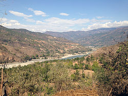
may refer to a religious ceremony attempting to divine prospects for the coming year from the level of water in a pot or well,
818:
781:
864:
338:
1845:
1840:
1550:
1385:
1835:
1686:
651:
844:
850:
838:
1915:
1431:
1141:
521:
The northern third of the
Nepalese portion of the Arun basin supports a rich, though human-modified, forest of
630:
1683:
1494:
938:
498:
apparent contradiction is caused by the location of more than 80 percent of the Arun's drainage area in the
334:
968:
459:
485:
The Sun Kosi contributes 44 per cent of the total water in the Sapta Koshi, the Arun 37 per cent and the
1576:
515:
318:
1424:
1327:
1050:
1744:
1390:
1307:
1095:
608:
1799:
1632:
1166:
1126:
1075:
745:
714:
683:
568:
422:
739:
708:
677:
1830:
1779:
1663:
1474:
1332:
1171:
1060:
948:
600:
94:
1879:
1825:
1784:
1759:
1754:
1722:
1658:
1566:
1545:
1509:
1034:
1024:
998:
983:
310:
1875:
1866:
1789:
1519:
1450:
1348:
1322:
1261:
1226:
1136:
1100:
1090:
1055:
710:
Himalayan Snow and
Glaciers: Associated Environmental Problems, Progress, and Prospects
191:
1904:
1884:
1861:
1749:
1699:
1694:
1673:
1622:
1581:
1540:
1364:
1312:
1281:
1241:
1221:
1146:
1085:
1019:
434:
414:
410:
1794:
1586:
1405:
1400:
1317:
1286:
1266:
1251:
1246:
1194:
1080:
1065:
1029:
917:
806:
770:
558:
534:
479:
382:
35:
413:
of Tibet. Around 17 kilometres (11 mi) downstream, the Men-chu joins it. The
562:
421:, Ra-chu Tsangpo, and Langkor Gya-chu. The Yeru Tsanpo converges with Bum-chu in
1602:
1524:
1514:
1504:
1484:
1469:
1395:
1231:
1216:
1211:
1156:
1151:
1121:
1116:
1003:
988:
978:
958:
943:
922:
912:
887:
499:
486:
475:
471:
463:
447:
322:
297:
179:
175:
165:
1499:
1489:
1479:
1447:
1256:
1236:
1184:
1161:
1070:
973:
963:
451:
418:
326:
258:
20:
655:
224:
211:
1889:
1717:
1617:
1612:
1571:
1380:
1291:
1276:
1271:
953:
526:
503:
467:
426:
506:. Average annual rainfall in Tibet is about 300 millimetres (12 in).
1871:
1642:
1131:
993:
455:
171:
538:(3,300 ft) in widely scattered villages near the slopes they farm.
1804:
856:
626:
612:
510:
1637:
1607:
778:
Proceedings of two
Lausanne Symposia, August 1990, IAHS publ. no. 193
430:
41:
604:
780:. International Association of Hydrological Sciences. p. 778.
1736:
1732:
1709:
1627:
891:
409:
is the
Tibetan word for water. The river originates near Gutso in
386:
330:
195:
154:
125:
115:
111:
45:
591:
Morris, captain C.J. (September 1923). "The Gorge of the Arun".
1420:
860:
530:
1416:
771:"Hydrology and development of the Arun River, Nepal"
450:
or Sapta Koshi drains eastern Nepal. It is known as
1854:
1813:
1772:
1731:
1708:
1682:
1672:
1651:
1595:
1559:
1533:
1457:
1373:
1357:
1341:
1300:
1204:
1109:
1043:
1012:
931:
905:
898:
482:in a southerly direction to emerge from the hills.
291:
281:
273:
268:
252:
244:
201:
185:
164:
148:
140:
131:
121:
107:
102:
82:
28:
66:
1432:
872:
381:is an upper tributary draining glaciers from
86:
8:
853:, OpenStreetMap, retrieved 19 December 2021.
847:, OpenStreetMap, retrieved 19 December 2021.
841:, OpenStreetMap, retrieved 19 December 2021.
1679:
1439:
1425:
1417:
902:
879:
865:
857:
713:. Concept Publishing Company. p. 90.
627:"Sikkim info - Bumchu Festival of Sikkim"
429:directly between the mountain massifs of
1577:Mahabharat Range (Lower Himalayan Range)
586:
584:
553:
551:
547:
478:. The combined river flows through the
567:. Bath, England: Footprint Handbooks.
25:
679:Himalayan Rivers, Lakes, and Glaciers
7:
787:from the original on July 21, 2011
14:
1187:
758:from the original on 2018-04-26.
744:. Orient Blackswan. p. 70.
727:from the original on 2018-04-26.
696:from the original on 2018-04-26.
682:. Indus Publishing. p. 89.
65:
58:
34:
824:from the original on 2011-07-21
633:from the original on 2010-06-12
652:"Bumchu - Sikkim Online Guide"
389:, the river's name changes to
357:In Tibet, the river is called
203: • coordinates
1:
999:Tama Kosi or Rongshar Tsangpo
132:Physical characteristics
1921:International rivers of Asia
1551:Sino-Nepal Friendship Bridge
1386:Inner Terai Valleys of Nepal
769:Kattelmann, Richard (1990).
1520:Sunkoshi or Matsang Tsangpo
1101:Trishuli or Kyirong Tsangpo
994:Sun Kosi or Matsang Tsangpo
254: • location
187: • location
150: • location
87:
1937:
1687:Autonomous Region of China
676:Sharad Singh Negi (1991).
339:People's Republic of China
74:Location of mouth in Nepal
18:
1182:
314:
264:
240:
160:
136:
53:
33:
1911:Rivers of Koshi Province
707:Jagdish Bahadur (2004).
593:The Geographical Journal
293: • right
40:View of Arun River from
19:Not to be confused with
16:River in China and Nepal
1534:Dams, barrages, bridges
341:where it is called the
335:Tibet Autonomous Region
287:Yeru Tsanpo, Trakar-chu
283: • left
361:, also transliterated
1560:Geographical features
516:1988 Nepal earthquake
225:26.91306°N 87.15694°E
1596:Important localities
949:Bhote Koshi or Boqu
741:India's Water Wealth
319:trans-boundary river
1086:Narayani or Gandaki
365:or from Chinese as
333:. It originates in
321:and is part of the
269:Basin features
221: /
1821:Friendship Highway
1790:Nepal Bhasa/Newari
1745:Darbhanga division
1391:Kali Gandaki Gorge
974:Kosi or Sapta Kosi
808:Kattelmann, 1990,
470:, the Arun River,
230:26.91306; 87.15694
1898:
1897:
1773:Languages/ people
1768:
1767:
1414:
1413:
1180:
1179:
1157:Sarda or Mahakali
1132:Karnali or Ghagra
932:Sapta Koshi basin
751:978-81-250-0704-3
738:K.L. Rao (1979).
720:978-81-8069-091-4
689:978-81-85182-61-2
574:978-1-900949-33-0
442:Kosi River System
401:The Tibetan name
303:
302:
1928:
1831:Mahendra Highway
1780:Standard Tibetan
1680:
1676:districts/ areas
1664:2008 Bihar flood
1441:
1434:
1427:
1418:
1197:
1192:
1191:
1190:
1172:West Rapti River
1061:East Rapti River
903:
881:
874:
867:
858:
851:Sapta Kosi River
826:
825:
823:
816:
803:
797:
796:
794:
792:
786:
775:
766:
760:
759:
735:
729:
728:
704:
698:
697:
673:
667:
666:
664:
663:
654:. Archived from
648:
642:
641:
639:
638:
623:
617:
616:
588:
579:
578:
555:
329:river system in
316:
294:
284:
255:
236:
235:
233:
232:
231:
226:
222:
219:
218:
217:
214:
170:Confluence with
151:
98:
90:
69:
68:
62:
38:
26:
1936:
1935:
1931:
1930:
1929:
1927:
1926:
1925:
1916:Rivers of Tibet
1901:
1900:
1899:
1894:
1850:
1826:Araniko Highway
1809:
1764:
1760:Munger division
1755:Purnia division
1727:
1723:Sagarmatha Zone
1704:
1668:
1659:Floods in Bihar
1647:
1603:Nyalam/ Tsongdu
1591:
1567:Tibetan Plateau
1555:
1546:Kosi embankment
1529:
1453:
1445:
1415:
1410:
1369:
1353:
1337:
1296:
1200:
1193:
1188:
1186:
1176:
1105:
1039:
1008:
939:Arun or Bum-chu
927:
906:Mahananda basin
894:
885:
835:
830:
829:
821:
817:, p. 778,
814:
805:
804:
800:
790:
788:
784:
773:
768:
767:
763:
752:
737:
736:
732:
721:
706:
705:
701:
690:
675:
674:
670:
661:
659:
650:
649:
645:
636:
634:
625:
624:
620:
605:10.2307/1780654
590:
589:
582:
575:
557:
556:
549:
544:
523:mixed hardwoods
495:
460:Indravati River
444:
399:
355:
292:
282:
253:
229:
227:
223:
220:
215:
212:
210:
208:
207:
204:
188:
149:
92:
78:
77:
76:
75:
72:
71:
70:
49:
24:
17:
12:
11:
5:
1934:
1932:
1924:
1923:
1918:
1913:
1903:
1902:
1896:
1895:
1893:
1892:
1887:
1882:
1869:
1864:
1858:
1856:
1852:
1851:
1849:
1848:
1843:
1838:
1833:
1828:
1823:
1817:
1815:
1811:
1810:
1808:
1807:
1802:
1797:
1792:
1787:
1782:
1776:
1774:
1770:
1769:
1766:
1765:
1763:
1762:
1757:
1752:
1747:
1741:
1739:
1729:
1728:
1726:
1725:
1720:
1714:
1712:
1706:
1705:
1703:
1702:
1700:Tingri County
1697:
1691:
1689:
1677:
1670:
1669:
1667:
1666:
1661:
1655:
1653:
1649:
1648:
1646:
1645:
1640:
1635:
1630:
1625:
1620:
1615:
1610:
1605:
1599:
1597:
1593:
1592:
1590:
1589:
1584:
1579:
1574:
1569:
1563:
1561:
1557:
1556:
1554:
1553:
1548:
1543:
1537:
1535:
1531:
1530:
1528:
1527:
1522:
1517:
1512:
1507:
1502:
1497:
1492:
1487:
1482:
1477:
1472:
1467:
1461:
1459:
1455:
1454:
1446:
1444:
1443:
1436:
1429:
1421:
1412:
1411:
1409:
1408:
1403:
1398:
1393:
1388:
1383:
1377:
1375:
1374:Related topics
1371:
1370:
1368:
1367:
1361:
1359:
1358:Dams, barrages
1355:
1354:
1352:
1351:
1345:
1343:
1339:
1338:
1336:
1335:
1330:
1325:
1320:
1315:
1310:
1304:
1302:
1298:
1297:
1295:
1294:
1289:
1284:
1279:
1274:
1269:
1264:
1259:
1254:
1249:
1244:
1239:
1234:
1229:
1227:Ghodaghodi Tal
1224:
1219:
1214:
1208:
1206:
1202:
1201:
1199:
1198:
1183:
1181:
1178:
1177:
1175:
1174:
1169:
1164:
1159:
1154:
1149:
1144:
1139:
1134:
1129:
1124:
1119:
1113:
1111:
1107:
1106:
1104:
1103:
1098:
1093:
1091:Rahughat Khola
1088:
1083:
1078:
1073:
1068:
1063:
1058:
1053:
1047:
1045:
1044:Narayani basin
1041:
1040:
1038:
1037:
1032:
1027:
1022:
1016:
1014:
1010:
1009:
1007:
1006:
1001:
996:
991:
986:
981:
976:
971:
966:
961:
956:
951:
946:
941:
935:
933:
929:
928:
926:
925:
920:
915:
909:
907:
900:
896:
895:
886:
884:
883:
876:
869:
861:
855:
854:
848:
845:Sun Kosi River
842:
834:
833:External links
831:
828:
827:
798:
761:
750:
730:
719:
699:
688:
668:
643:
618:
599:(3): 161–168.
580:
573:
564:Tibet Handbook
546:
545:
543:
540:
494:
491:
443:
440:
423:Tingkye County
398:
395:
354:
351:
301:
300:
295:
289:
288:
285:
279:
278:
275:
271:
270:
266:
265:
262:
261:
256:
250:
249:
246:
242:
241:
238:
237:
205:
202:
199:
198:
189:
186:
183:
182:
168:
162:
161:
158:
157:
152:
146:
145:
142:
138:
137:
134:
133:
129:
128:
123:
119:
118:
109:
105:
104:
100:
99:
84:
80:
79:
73:
64:
63:
57:
56:
55:
54:
51:
50:
39:
31:
30:
15:
13:
10:
9:
6:
4:
3:
2:
1933:
1922:
1919:
1917:
1914:
1912:
1909:
1908:
1906:
1891:
1888:
1886:
1883:
1881:
1877:
1873:
1870:
1868:
1865:
1863:
1860:
1859:
1857:
1853:
1847:
1844:
1842:
1839:
1837:
1834:
1832:
1829:
1827:
1824:
1822:
1819:
1818:
1816:
1812:
1806:
1803:
1801:
1798:
1796:
1793:
1791:
1788:
1786:
1783:
1781:
1778:
1777:
1775:
1771:
1761:
1758:
1756:
1753:
1751:
1750:Kosi division
1748:
1746:
1743:
1742:
1740:
1738:
1734:
1730:
1724:
1721:
1719:
1716:
1715:
1713:
1711:
1707:
1701:
1698:
1696:
1695:Nyalam County
1693:
1692:
1690:
1688:
1685:
1681:
1678:
1675:
1671:
1665:
1662:
1660:
1657:
1656:
1654:
1650:
1644:
1641:
1639:
1636:
1634:
1631:
1629:
1626:
1624:
1623:Namche Bazaar
1621:
1619:
1616:
1614:
1611:
1609:
1606:
1604:
1601:
1600:
1598:
1594:
1588:
1585:
1583:
1582:Sivalik Hills
1580:
1578:
1575:
1573:
1570:
1568:
1565:
1564:
1562:
1558:
1552:
1549:
1547:
1544:
1542:
1541:Koshi Barrage
1539:
1538:
1536:
1532:
1526:
1523:
1521:
1518:
1516:
1513:
1511:
1508:
1506:
1503:
1501:
1498:
1496:
1493:
1491:
1488:
1486:
1483:
1481:
1478:
1476:
1473:
1471:
1468:
1466:
1463:
1462:
1460:
1456:
1452:
1449:
1442:
1437:
1435:
1430:
1428:
1423:
1422:
1419:
1407:
1404:
1402:
1399:
1397:
1394:
1392:
1389:
1387:
1384:
1382:
1379:
1378:
1376:
1372:
1366:
1365:Koshi Barrage
1363:
1362:
1360:
1356:
1350:
1347:
1346:
1344:
1340:
1334:
1331:
1329:
1326:
1324:
1321:
1319:
1316:
1314:
1311:
1309:
1306:
1305:
1303:
1299:
1293:
1290:
1288:
1285:
1283:
1282:Salpa Pokhari
1280:
1278:
1275:
1273:
1270:
1268:
1265:
1263:
1260:
1258:
1255:
1253:
1250:
1248:
1245:
1243:
1242:Gupha Pokhari
1240:
1238:
1235:
1233:
1230:
1228:
1225:
1223:
1222:Bishazari Tal
1220:
1218:
1215:
1213:
1210:
1209:
1207:
1203:
1196:
1185:
1173:
1170:
1168:
1165:
1163:
1160:
1158:
1155:
1153:
1150:
1148:
1145:
1143:
1140:
1138:
1135:
1133:
1130:
1128:
1125:
1123:
1120:
1118:
1115:
1114:
1112:
1110:Karnali basin
1108:
1102:
1099:
1097:
1094:
1092:
1089:
1087:
1084:
1082:
1079:
1077:
1074:
1072:
1069:
1067:
1064:
1062:
1059:
1057:
1054:
1052:
1051:Budhi Gandaki
1049:
1048:
1046:
1042:
1036:
1033:
1031:
1028:
1026:
1023:
1021:
1018:
1017:
1015:
1013:Bagmati basin
1011:
1005:
1002:
1000:
997:
995:
992:
990:
987:
985:
982:
980:
977:
975:
972:
970:
967:
965:
962:
960:
957:
955:
952:
950:
947:
945:
942:
940:
937:
936:
934:
930:
924:
921:
919:
916:
914:
911:
910:
908:
904:
901:
897:
893:
889:
882:
877:
875:
870:
868:
863:
862:
859:
852:
849:
846:
843:
840:
837:
836:
832:
820:
813:
812:
809:
802:
799:
783:
779:
772:
765:
762:
757:
753:
747:
743:
742:
734:
731:
726:
722:
716:
712:
711:
703:
700:
695:
691:
685:
681:
680:
672:
669:
658:on 2010-02-17
657:
653:
647:
644:
632:
628:
622:
619:
614:
610:
606:
602:
598:
594:
587:
585:
581:
576:
570:
566:
565:
560:
554:
552:
548:
541:
539:
536:
532:
528:
524:
519:
517:
512:
507:
505:
501:
492:
490:
489:19 per cent.
488:
483:
481:
477:
473:
469:
465:
461:
457:
453:
449:
441:
439:
436:
435:Kangchenjunga
432:
428:
424:
420:
416:
415:Tingri county
412:
411:Nyalam County
408:
404:
396:
394:
392:
388:
384:
380:
376:
372:
368:
364:
360:
352:
350:
348:
344:
340:
336:
332:
328:
324:
320:
312:
308:
299:
296:
290:
286:
280:
276:
272:
267:
263:
260:
257:
251:
247:
243:
239:
234:
206:
200:
197:
193:
190:
184:
181:
177:
173:
169:
167:
163:
159:
156:
153:
147:
143:
139:
135:
130:
127:
124:
120:
117:
113:
110:
106:
101:
96:
89:
85:
81:
61:
52:
47:
43:
37:
32:
27:
22:
1855:Other basins
1587:Chatra Gorge
1465:Arun/Bum-chu
1464:
1406:Chatra Gorge
1401:Barun Valley
1267:Rani Pokhari
1252:Kubinde Daha
1247:Khaptad Lake
1195:Nepal portal
1096:Seti Gandaki
1081:Myagdi Khola
1066:Kali Gandaki
811:
807:
801:
789:. Retrieved
777:
764:
740:
733:
709:
702:
678:
671:
660:. Retrieved
656:the original
646:
635:. Retrieved
621:
596:
592:
563:
559:Gyurme Dorje
535:rhododendron
520:
508:
496:
484:
480:Chatra Gorge
445:
406:
402:
400:
390:
383:Shishapangma
378:
374:
370:
366:
362:
358:
356:
346:
342:
306:
304:
1396:Western Cwm
1328:Lhotse Shar
1212:Begnas Lake
1167:Thuli Bheri
1127:Budhi Ganga
1076:Marshyangdi
923:Ratua Khola
888:Hydrography
500:rain shadow
476:Tamur River
472:Barun River
464:Bhoté Koshi
298:Barun River
274:Tributaries
228: /
192:Tribenighat
176:Tamur River
83:Native name
1905:Categories
1490:Imja Khola
1480:Dudh Koshi
1475:Bhotekoshi
1308:Ambulapcha
1237:Gosaikunda
1217:Bharat Tal
964:Imja Khola
839:Arun River
662:2010-05-28
637:2010-05-28
542:References
452:Sapt Koshi
419:Kharda-chu
327:Sapt Koshi
307:Arun River
259:Kosi river
216:87°09′25″E
213:26°54′47″N
180:Sapta Kosi
23:, England.
21:River Arun
1880:Baitarani
1814:Transport
1718:Kosi Zone
1633:Bhimnagar
1618:Bahrabise
1613:Dolalghat
1572:Himalayas
1510:Sangkhuwa
1495:Indravati
1381:Gorakshep
1292:Imja Tsho
1262:Phoksundo
1035:Lakhandei
1025:Bisnumati
984:Sangkhuwa
969:Indravati
954:Dudh Kosi
527:Chir pine
511:monsoonal
504:Himalayas
468:Dudh Kosi
427:Himalayas
363:Phung-Chu
343:Phung Chu
245:Discharge
1876:Brahmani
1872:Mahanadi
1867:Godavari
1800:Maithili
1674:Riparian
1643:Khagaria
1342:Icefalls
1333:Ngozumpa
1301:Glaciers
1137:Kalapani
1056:Daraundi
819:archived
810:op. cit.
782:Archived
756:Archived
725:Archived
694:Archived
631:Archived
561:(1999).
456:Sun Kosi
315:अरुण नदी
178:to form
172:Sun Kosi
103:Location
1885:Narmada
1862:Damodar
1805:Bajjika
1287:Tilicho
1147:Panjang
1020:Bagmati
791:May 27,
613:1780654
502:of the
403:Bum-chu
367:Peng Qu
359:Bum-chu
347:Bum-chu
337:of the
317:) is a
108:Country
95:Chinese
88:Bum-chu
44:VDC of
1846:NH 107
1841:NH 106
1785:Nepali
1652:Floods
1638:Supaul
1608:Kodari
1458:Rivers
1349:Khumbu
1323:Khumbu
1152:Rohini
1030:Kamala
918:Kankai
899:Rivers
748:
717:
686:
611:
571:
533:, and
474:, and
466:, the
462:, the
458:, the
431:Makalu
379:Moinqu
375:Men Qu
373:. The
311:Nepali
277:
248:
141:Source
91:
42:Leguwa
1836:NH 27
1795:Limbu
1737:India
1733:Bihar
1710:Nepal
1684:Tibet
1628:Lukla
1525:Tamur
1515:Siswa
1505:Sabha
1485:Hongu
1470:Barun
1451:basin
1313:Hunku
1257:Phewa
1232:Gokyo
1205:Lakes
1122:Bheri
1117:Babai
1004:Tamor
989:Siswa
979:Sabha
959:Hongu
944:Barun
913:Mechi
892:Nepal
822:(PDF)
815:(PDF)
785:(PDF)
774:(PDF)
609:JSTOR
493:Nepal
487:Tamur
397:Tibet
387:Nepal
385:. In
371:Pumqu
331:Nepal
196:Nepal
166:Mouth
155:Tibet
144:Gutso
126:Tibet
122:State
116:China
112:Nepal
46:Nepal
1500:Kosi
1448:Kosi
1318:Imja
1277:Rupa
1272:Rara
1162:Seti
1142:Kali
1071:Madi
793:2011
746:ISBN
715:ISBN
684:ISBN
569:ISBN
448:Kosi
446:The
433:and
391:Arun
353:Name
323:Kosi
305:The
174:and
29:Arun
1890:Son
890:of
601:doi
531:fir
407:chu
377:or
369:or
345:or
325:or
1907::
1735:,
776:.
754:.
723:.
692:.
629:.
607:.
597:62
595:.
583:^
550:^
529:,
525:,
393:.
349:.
313::
194:,
114:,
1878:–
1874:–
1440:e
1433:t
1426:v
880:e
873:t
866:v
795:.
665:.
640:.
615:.
603::
577:.
309:(
97:)
93:(
48:.
Text is available under the Creative Commons Attribution-ShareAlike License. Additional terms may apply.