59:
371:
43:
475:
66:
327:
85.1% of residents were born in
Australia, substantially higher than the national average of 66.7%. The most common responses for religion were Catholic 28.4%, No Religion 24.5%, Anglican 21.8%, and Presbyterian and Reformed 4.4%. 9.7% of respondents did not answer the question. Christianity was the
331:
12.8% of residents reported being unemployed, nearly double the national average. Median incomes in the suburb were notably lower than average. The median weekly personal income reported was $ 505, compared to $ 662 nationally. The median weekly household income was $ 876, compared to $ 1,438
323:
At the 2016 census, the median age in
Ashmont is 33, younger than the national average of 38. Aboriginal and/or Torres Strait Islander people constitute 18.0% of the population, significantly higher than the national average of 2.8%.
301:). As of 2019, 21% of dwellings in Ashmont are owned by a federal or state housing authority. The suburb has a high rate of social disadvantage and crime, with crime rates significantly higher compared to state-wide averages.
195:
183:
58:
95:
812:
161:
506:
756:
558:
149:
305:
297:
Ashmont was first urbanised in the late 1950s, and during the 1970s large areas were developed by the then State
Housing Commission (now known as
418:
309:
479:
836:
553:
387:
188:
399:
173:
831:
805:
588:
349:
258:
166:
593:
499:
699:
633:
578:
519:
263:
668:
643:
618:
603:
583:
543:
283:
246:
238:
231:
88:
648:
212:
484:
798:
729:
724:
613:
598:
563:
548:
492:
413:
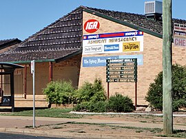
294:. The suburb is named after the Salmon family's original homestead that was located where the suburb now stands.
709:
663:
653:
628:
608:
573:
253:
226:
221:
719:
714:
658:
445:
623:
538:
353:
139:
131:
734:
315:
The
Carmelite Monastery, a community of monastic, contemplative nuns, is situated on Morsehead Street.
200:
516:
154:
638:
383:
782:
568:
42:
287:
33:
370:
825:
332:
nationally. A plurality of families with children, 27.3% had neither parent working.
328:
largest religious group reported overall, at 71.1% (excluding not stated responses).
673:
423:
382:
Morris, S (1999). Wagga Wagga, a history. Bobby Graham
Publishers, Wagga Wagga.
298:
29:
744:
704:
694:
689:
110:
97:
778:
291:
474:
282:, known originally as "J.J. Salmon's Estate" is a south-western suburb of
775:
739:
449:
488:
312:
786:
682:
526:
194:
182:
172:
160:
148:
138:
126:
87:
23:
18:Suburb of Wagga Wagga, New South Wales, Australia
207:
806:
500:
8:
813:
799:
507:
493:
485:
369:
41:
20:
757:Local government areas of New South Wales
341:
306:New South Wales State Emergency Service
414:"Is Ashmont Wagga's Struggle Street?"
251:
236:
219:
209:
7:
771:
769:
785:. You can help Knowledge (XXG) by
310:New South Wales Rural Fire Service
14:
446:"Carmelite Monastery Wagga Wagga"
473:
64:
57:
350:Australian Bureau of Statistics
65:
1:
304:A small shopping centre, the
853:
768:
111:35.1271278°S 147.3320778°E
753:
515:Suburbs and towns in the
400:"Public Housing Heat Map"
269:
210:
206:
83:
52:
40:
837:Riverina geography stubs
559:Charles Sturt University
480:Ashmont, New South Wales
354:"Ashmont (State Suburb)"
308:Murrumbidgee Region and
116:-35.1271278; 147.3320778
832:Suburbs of Wagga Wagga
358:2016 Census QuickStats
520:local government area
482:at Wikimedia Commons
517:City of Wagga Wagga
196:Federal division(s)
184:State electorate(s)
155:City of Wagga Wagga
107: /
794:
793:
763:
762:
639:North Wagga Wagga
478:Media related to
452:on 26 August 2014
277:
276:
273:
272:
178:South Wagga Wagga
844:
815:
808:
801:
770:
569:East Wagga Wagga
554:Cartwrights Hill
509:
502:
495:
486:
477:
462:
461:
459:
457:
448:. Archived from
442:
436:
435:
433:
431:
419:Daily Advertiser
410:
404:
403:
396:
390:
380:
374:
373:
368:
366:
364:
352:(27 June 2017).
346:
208:
122:
121:
119:
118:
117:
112:
108:
105:
104:
103:
100:
68:
67:
61:
45:
36:
26:
21:
852:
851:
847:
846:
845:
843:
842:
841:
822:
821:
820:
819:
766:
764:
759:
749:
683:Outlying towns:
678:
522:
513:
471:
466:
465:
455:
453:
444:
443:
439:
429:
427:
412:
411:
407:
398:
397:
393:
381:
377:
362:
360:
348:
347:
343:
338:
321:
288:New South Wales
215:around Ashmont:
115:
113:
109:
106:
101:
98:
96:
94:
93:
79:
78:
77:
76:
75:
74:
73:
69:
48:
34:New South Wales
28:
27:
24:
19:
12:
11:
5:
850:
848:
840:
839:
834:
824:
823:
818:
817:
810:
803:
795:
792:
791:
761:
760:
755:Main Article:
754:
751:
750:
748:
747:
742:
737:
732:
727:
722:
717:
712:
707:
702:
697:
692:
686:
684:
680:
679:
677:
676:
671:
666:
661:
656:
651:
646:
641:
636:
631:
626:
621:
616:
611:
606:
601:
596:
591:
589:Glenfield Park
586:
581:
576:
571:
566:
561:
556:
551:
546:
541:
536:
530:
528:
524:
523:
514:
512:
511:
504:
497:
489:
470:
469:External links
467:
464:
463:
437:
405:
391:
375:
340:
339:
337:
334:
320:
317:
275:
274:
271:
270:
267:
266:
261:
259:Glenfield Park
256:
250:
249:
244:
241:
235:
234:
229:
224:
218:
217:
204:
203:
198:
192:
191:
186:
180:
179:
176:
170:
169:
164:
158:
157:
152:
146:
145:
142:
136:
135:
128:
124:
123:
102:147°19′55.48″E
91:
85:
84:
81:
80:
71:
70:
63:
62:
56:
55:
54:
53:
50:
49:
46:
38:
37:
17:
13:
10:
9:
6:
4:
3:
2:
849:
838:
835:
833:
830:
829:
827:
816:
811:
809:
804:
802:
797:
796:
790:
788:
784:
781:article is a
780:
777:
772:
767:
758:
752:
746:
743:
741:
738:
736:
733:
731:
728:
726:
723:
721:
718:
716:
713:
711:
708:
706:
703:
701:
698:
696:
693:
691:
688:
687:
685:
681:
675:
672:
670:
667:
665:
662:
660:
657:
655:
652:
650:
647:
645:
642:
640:
637:
635:
632:
630:
627:
625:
622:
620:
617:
615:
612:
610:
607:
605:
602:
600:
597:
595:
594:Gobbagombalin
592:
590:
587:
585:
582:
580:
577:
575:
572:
570:
567:
565:
562:
560:
557:
555:
552:
550:
547:
545:
542:
540:
537:
535:
532:
531:
529:
525:
521:
518:
510:
505:
503:
498:
496:
491:
490:
487:
483:
481:
476:
468:
451:
447:
441:
438:
426:. 16 May 2015
425:
421:
420:
415:
409:
406:
401:
395:
392:
389:
388:1-875247-12-2
385:
379:
376:
372:
359:
355:
351:
345:
342:
335:
333:
329:
325:
318:
316:
313:
311:
307:
302:
300:
295:
293:
289:
285:
281:
268:
265:
262:
260:
257:
255:
252:
248:
245:
242:
240:
237:
233:
230:
228:
225:
223:
220:
216:
214:
205:
202:
199:
197:
193:
190:
187:
185:
181:
177:
175:
171:
168:
165:
163:
159:
156:
153:
151:
147:
143:
141:
137:
133:
129:
125:
120:
92:
90:
86:
82:
60:
51:
44:
39:
35:
31:
22:
16:
787:expanding it
773:
765:
700:Collingullie
634:Mount Austin
579:Eunanoreenya
533:
472:
454:. Retrieved
450:the original
440:
428:. Retrieved
417:
408:
394:
378:
361:. Retrieved
357:
344:
330:
326:
322:
319:Demographics
314:
303:
296:
279:
278:
264:Mount Austin
211:
130:3,828 (
99:35°7′37.66″S
47:Ashmont Mall
15:
674:Wagga Wagga
669:Turvey Park
644:San Isidore
619:Lake Albert
604:Gumly Gumly
584:Forest Hill
544:Bourkelands
424:Wagga Wagga
299:Housing NSW
284:Wagga Wagga
247:Turvey Park
239:San Isidore
232:Wagga Wagga
189:Wagga Wagga
140:Postcode(s)
132:2016 census
114: /
89:Coordinates
30:Wagga Wagga
826:Categories
745:Uranquinty
705:Currawarna
695:Burrandana
690:Alfredtown
649:Springvale
430:29 January
336:References
127:Population
779:geography
730:Mangoplah
725:Ladysmith
614:Kooringal
456:26 August
292:Australia
776:Riverina
740:Tarcutta
599:Gregadoo
564:Downside
549:Boorooma
527:Suburbs:
201:Riverina
710:Dhulura
664:Tolland
654:The Gap
629:Moorong
609:Kapooka
574:Estella
534:Ashmont
363:27 June
280:Ashmont
254:Kapooka
243:Ashmont
227:Moorong
222:Moorong
213:Suburbs
167:Wynyard
72:Ashmont
32:,
25:Ashmont
720:Humula
715:Galore
659:Tatton
386:
174:Parish
162:County
150:LGA(s)
774:This
624:Lloyd
539:Bomen
783:stub
735:Oura
458:2014
432:2019
384:ISBN
365:2017
144:2650
828::
422:.
416:.
356:.
290:,
286:,
814:e
807:t
800:v
789:.
508:e
501:t
494:v
460:.
434:.
402:.
367:.
134:)
Text is available under the Creative Commons Attribution-ShareAlike License. Additional terms may apply.