1189:
1177:
1229:
1201:
552:, the total population of the village stands at 22,936, with a male population of 10,938 and a female population of 11,998. In terms of percentage, males constitute some 47.69% and females constitute about 52.31% of the total population. Likewise, the sex ratio is 91.17, which means there are about 91 males for every 100 females in the VDC. The total number of households in the village is 5,270, with an average household size of 4.35. Moreover, the population density of the VDC comes to be around 723 persons per square kilometer, which is about fourfold higher than the national population density.
1165:
1213:
95:
79:
55:
67:
1241:
1055:, which is the most popular cash crop in the area. Rubber, tea, and cardamom farms are also sparingly common. As for the industries, most of the industries are small-scale and agro-based. There are 30 rice mills and over 12 timber mills in the village. Moreover, a significant fraction of village's active population works abroad, especially in the Gulf countries, and foreign remittances contribute a great deal to the local economy.
1619:
1069:
164:
102:
1176:
1200:
1009:, Budhabare has a male literacy rate of 85.77% and a female literacy rate of 74.34%. Overall, the literacy rate of the village stands at 79.76%, which is higher than the national average of 65.9%. There are more than a dozen of schools operating in and around the Budhabare area, and all of them are
1129:
Budhabare is home to numerous temple sites that are sacred to Hindu devotees. Pilgrims and worshippers from all over the village and other places flock to these religious spaces during special occasions. Some of the eminent holy places located across the several wards of the village include:
1038:
health facilities. The area has good access to road transport. The Mechi
Highway, which connects all the districts of the Mechi zone, runs through the village. It has a network of part black topped and part graveled road within its area. Most areas are thus easily accessible.
540:. Hadiya Khola also runs from north to south, but close to the eastern border. The area close to the two streams is mainly composed of gravel, boulder, and sand. However, the rest and much of Budhabare is primarily composed of silty loamy soil, which is ideal for agriculture.
560:
The active population of the VDC is 14,415, which is about 63.29% of the total population. The table immediately below enumerates the population composition of the village on the basis of child dependent, economically active, and old dependent age-group respectively:
536:. It is generally flat in the south, while the northern part is rolling. The area is dissected by two major streams: Biring Khola and Hadiya Khola. Biring Khola runs from north to south along the western border, serving as a natural demarcation between Budhabare and
1188:
827:
An overwhelming majority of village population (82.68%) speak Nepali as mother tongue. Other spoken languages include Limbu (4.06%), Dhimal (2.02%), Rai (1.88%), etc. The table below enumerates all languages that at least have a three-digit population:
516:, the average temperature of Budhabare is 24.2 °C. About 2500 mm of precipitation falls annually. The driest month is December with little to no rainfall. Meanwhile, in July, the precipitation reaches its peak with an average of 719 mm.
1228:
1029:
Budhabare is moderately facilitated. For health services, there is a health post located near
Budhabare bazaar, which provides basic health care facilities to the local population. In addition to this health post, there also exists an
1164:
1206:
People gather to observe a street play on a
Wednesday in the bazaar area of Budhabare. Street plays like this usually carry with them a social message, and this one is on "Domestic Violence Against Women."
1405:
1182:
Farmlands of
Hattisude, Budhabare-9, as seen at the crack of dawn. Locals believe Hattisude to be one of the most fertile places for the production of rice in Jhapa and even across the country.
408:. Out of fears that a concurrent market day would be detrimental and challenging to business, they decided go with either Tuesday or Wednesday. As Tuesday is generally considered a
1471:
1013:. In addition to schools, a private campus by the name of Sita Ramesh Bahumukhi Campus has also been recently established in Budhabare-6, and offers graduate programs in
1284:
1047:
The primary economic activity of the village is agriculture. The land is very fertile and the rate of production is good, making this place an "agricultural hotspot" of
652:, etc. The table below mentions the major ethnic groups and bulks the minorities into "others," summing up the population composition of Budhabare on ethnicity basis:
1212:
416:
is the Nepali term for
Wednesday. This market, which started off in the early 1940s, still continues to this day and has become a major attraction of the village.
78:
1694:
412:, or brute day, in Nepali culture, Wednesday became the pick. Over time, the village came to be known after this day of the market as Budhabare, since
1240:
126:
1541:
444:
of 88.050179°E. The elevation of
Budhabare ranges from 149 m to 329 m above the mean sea level. The dominant tree species found in the area include
330:
66:
1482:
436:. Geographically, Budhabare covers a total area of 31.73 square kilometres. Pahari Chowk (roughly the center of Budhabare) lies at a
1116:
1090:
94:
353:, puts the total population of the VDC at 22,936. Owing to this average population size, the VDC has been divided into nine wards.
54:
1598:
640:, etc. are also fairly common ethnic groups found in the village. In addition, minority groups residing in the village include
1295:
1608:
1094:
1588:
364:
and the market that is held every
Wednesday. The market of Budhabare grew in importance tremendously after the highway to
1603:
1583:
1534:
1345:
1194:
Located in
Budhabare-6, Shree Krishna Pranami Mandir is an important religious site in and around the Budhabare area.
1660:
1380:
1234:
Distant shot of Shree Buddha
Adarsha Uccha Madhyamik Vidyalaya, the oldest educational institution in the village
505:
1593:
1578:
1079:
1655:
1635:
1527:
1170:
View of the water reservoir tower that was built as part of Small Town
Drinking Water and Sanitation Project
1098:
1083:
176:
1665:
1650:
1561:
1670:
1006:
549:
350:
501:
478:
389:
1645:
1051:
district. Food crops like paddy and maize are extensively cultivated. Most of the households plant
529:
388:
dates back to the early 1940s. Local legend has it that, at that time, an elite man by the name of
291:
1640:
188:
1346:"NEP: Third Small Towns Water Supply and Sanitation Sector Project – Budhabare, Jhapa District"
512:) with wet and hot summers and mild and dry winters. With reference to statistics furnished by
1134:
975:
936:
923:
645:
466:
429:
396:, in the village. This followed a similar trend that was already in practice on Saturday in
1381:"Role of Remittance in Rural Poverty Reduction - A Case Study of Budhabare-9, Jhapa, Nepal"
1507:
962:
897:
871:
845:
797:
1618:
1550:
1261:
1010:
949:
910:
858:
620:
who have descended from hills make up about 43.22% of Budhabare's populace. Similarly,
446:
342:
181:
1688:
1247:
884:
758:
533:
433:
405:
369:
1627:
734:
708:
695:
641:
637:
629:
625:
425:
334:
262:
259:
45:
1068:
365:
17:
356:
As the village is crossed by Hadiya Khola, it is sometimes also referred to as
1570:
1018:
721:
633:
537:
500:
just below the hills, the climate of Budhabare is temperately warm. Under the
397:
265:
1436:
141:
128:
1219:
1052:
441:
401:
361:
287:
282:
360:. The village of Budhabare is best known for two things: the production of
1035:
1014:
649:
437:
83:
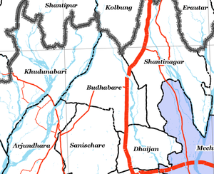
Zoomed-in map of Jhapa district showing Budhabare and its adjacent areas
1323:(in Nepali) (First ed.). Village Development Committee, Budhabare.
682:
621:
326:
272:
256:
784:
771:
483:
471:
459:
27:
Village of Buddhashanti Rural Municipality in Province No. 1, Nepal
1048:
669:
617:
525:
497:
373:
346:
338:
253:
193:
169:
1519:
1523:
428:, at a distance of 17 km north from district headquarters
1062:
1472:"National Population and Housing Census, 2011 (Jhapa)"
1481:. Central Bureau of Statistics, Nepal. Archived from
1294:. Central Bureau of Statistics, Nepal. Archived from
1285:"National Population and Housing Census 2011 (Nepal)"
1626:
1569:
1218:A village scene of Budhabare with maize plants and
308:
298:
281:
271:
249:
241:
233:
228:
220:
212:
204:
199:
187:
175:
157:
32:
524:Topographically, Budhabare area lies in the upper
400:, on Sunday in Aaitabare, on Friday and Monday in
368:was constructed, as Budhabare now lies along the
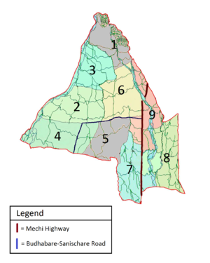
71:Map of Budhabare depicting its constituent wards
1374:
1372:
1370:
1682:Financial Institution: NICASIA Bank Limited
1535:
1466:
1464:
1462:
1460:
1458:
8:
1279:
1277:
1250:that passes through the village of Budhabare
1097:. Unsourced material may be challenged and
550:National Population and Housing Census 2011
1542:
1528:
1520:
392:began to organize a weekly market day, or
29:
1431:
1429:
1427:
1140:Shree Krishna Pranami Mandir, Budhabare-6
1117:Learn how and when to remove this message
432:and 8 km north of Charali along the
830:
654:
563:
496:Since the village lies in the flanks of
101:
1386:. Norwegian University of Life Sciences
1273:
1160:
297:
280:
270:
227:
219:
211:
198:
156:
121:
87:
63:
51:
1146:Kamleshwar Mahadev Mandir, Budhabare-5
372:, which connects all the districts of
1340:
1338:
1336:
1334:
1332:
1330:
307:
248:
240:
232:
208:31.73 km (12.25 sq mi)
203:
186:
174:
75:
7:
1095:adding citations to reliable sources
59:Bird's eye view of part of Budhabare
1437:"Climatic Data of Budhabare, Mechi"
1695:Populated places in Jhapa District
1406:"Co-ordinates of Budhabare, Mechi"
25:
1262:Budhabare, Mechi, on nepalmap.org
1149:Shree Hanuman Mandir, Budhabare-9
1143:Laxmi Narayan Mandir, Budhabare-6
1617:
1239:
1227:
1211:
1199:
1187:
1175:
1163:
1067:
504:classification, Budhabare has a
162:
100:
93:
77:
65:
53:
1152:Sitala Devi Mandir, Budhabare-5
426:Buddhashanti Rural Municipality
335:Buddhashanti Rural Municipality
46:Buddhashanti Rural Municipality
245:722.85/km (1,872.2/sq mi)
1:
331:Village Development Committee
532:, almost on the foot of the
349:. The latest official data,
484:
472:
460:
1711:
1508:The World Factbook :
216:329 m (1,079 ft)
1615:
1557:
506:humid subtropical climate
122:
88:
76:
64:
52:
42:
1355:. Asian Development Bank
424:Budhabare is located in
250: • Ethnicities
224:149 m (489 ft)
36:
1321:Budhabare: Hijo ra Aaja
1025:Facilities and services
384:The origin of the name
142:26.723838°N 88.050179°E
1034:, which renders basic
213:Highest elevation
404:, and on Thursday in
221:Lowest elevation
1571:Rural municipalities
1091:improve this section
1032:yurveda aushadhalaya
530:Indo-Gangetic plains
479:Neolamarckia cadamba
333:that is now part of
321:, more specifically
242: • Density
147:26.723838; 88.050179
1441:en.climate-data.org
1301:on 21 December 2016
1043:Economic activities
440:of 26.723838°N and
138: /
1443:. Climate-data.org
450:(locally known as
234: • Total
205: • Total
167:
1679:
1678:
1135:Ram Janaki Temple
1127:
1126:
1119:
1007:2011 Nepal Census
998:
997:
820:
819:
610:
609:
351:2011 Nepal Census
345:in south-eastern
316:
315:
114:Location in Nepal
16:(Redirected from
1702:
1621:
1544:
1537:
1530:
1521:
1514:
1504:
1498:
1497:
1495:
1493:
1487:
1476:
1468:
1453:
1452:
1450:
1448:
1433:
1422:
1421:
1419:
1417:
1402:
1396:
1395:
1393:
1391:
1385:
1376:
1365:
1364:
1362:
1360:
1350:
1342:
1325:
1324:
1317:
1311:
1310:
1308:
1306:
1300:
1289:
1281:
1243:
1231:
1215:
1203:
1191:
1179:
1167:
1122:
1115:
1111:
1108:
1102:
1071:
1063:
831:
655:
564:
514:climate-data.org
487:
475:
467:Dalbergia sissoo
463:
358:Hadiya Budhabare
323:Hadiya Budhabare
168:
166:
165:
153:
152:
150:
149:
148:
143:
139:
136:
135:
134:
131:
108:Hadiya Budhabare
104:
103:
97:
81:
69:
57:
34:Hadiya Budhabare
30:
21:
18:Budhabare, Mechi
1710:
1709:
1705:
1704:
1703:
1701:
1700:
1699:
1685:
1684:
1680:
1675:
1622:
1613:
1565:
1553:
1548:
1518:
1517:
1505:
1501:
1491:
1489:
1488:on 18 July 2016
1485:
1474:
1470:
1469:
1456:
1446:
1444:
1435:
1434:
1425:
1415:
1413:
1410:maps.google.com
1404:
1403:
1399:
1389:
1387:
1383:
1379:Bimala Pandey.
1378:
1377:
1368:
1358:
1356:
1348:
1344:
1343:
1328:
1319:
1318:
1314:
1304:
1302:
1298:
1287:
1283:
1282:
1275:
1270:
1258:
1251:
1244:
1235:
1232:
1223:
1216:
1207:
1204:
1195:
1192:
1183:
1180:
1171:
1168:
1159:
1123:
1112:
1106:
1103:
1088:
1072:
1061:
1059:Religious sites
1045:
1027:
1003:
825:
670:Brahmins (Hill)
615:
558:
546:
522:
494:
422:
382:
304:
163:
161:
146:
144:
140:
137:
132:
129:
127:
125:
124:
118:
117:
116:
115:
112:
111:
110:
109:
105:
84:
72:
60:
48:
38:
35:
28:
23:
22:
15:
12:
11:
5:
1708:
1706:
1698:
1697:
1687:
1686:
1677:
1676:
1674:
1673:
1668:
1663:
1658:
1653:
1648:
1643:
1638:
1632:
1630:
1628:Municipalities
1624:
1623:
1616:
1614:
1612:
1611:
1606:
1601:
1596:
1591:
1586:
1581:
1575:
1573:
1567:
1566:
1560:Headquarters:
1558:
1555:
1554:
1551:Jhapa District
1549:
1547:
1546:
1539:
1532:
1524:
1516:
1515:
1499:
1454:
1423:
1397:
1366:
1326:
1312:
1272:
1271:
1269:
1266:
1265:
1264:
1257:
1256:External links
1254:
1253:
1252:
1245:
1238:
1236:
1233:
1226:
1224:
1217:
1210:
1208:
1205:
1198:
1196:
1193:
1186:
1184:
1181:
1174:
1172:
1169:
1162:
1158:
1155:
1154:
1153:
1150:
1147:
1144:
1141:
1138:
1125:
1124:
1075:
1073:
1066:
1060:
1057:
1044:
1041:
1026:
1023:
1011:co-educational
1002:
999:
996:
995:
992:
989:
985:
984:
981:
978:
972:
971:
968:
965:
959:
958:
955:
952:
946:
945:
942:
939:
933:
932:
929:
926:
920:
919:
916:
913:
907:
906:
903:
900:
894:
893:
890:
887:
881:
880:
877:
874:
868:
867:
864:
861:
855:
854:
851:
848:
842:
841:
838:
835:
824:
821:
818:
817:
814:
811:
807:
806:
803:
800:
794:
793:
790:
787:
781:
780:
777:
774:
768:
767:
764:
761:
755:
754:
751:
748:
744:
743:
740:
737:
731:
730:
727:
724:
718:
717:
714:
711:
705:
704:
701:
698:
692:
691:
688:
685:
679:
678:
675:
672:
666:
665:
662:
659:
614:
611:
608:
607:
604:
601:
597:
596:
593:
590:
586:
585:
582:
579:
575:
574:
571:
568:
557:
554:
545:
542:
528:region of the
521:
518:
493:
490:
456:Acacia catechu
447:Shorea robusta
421:
418:
390:Romhorse Karki
381:
378:
343:Province No. 1
314:
313:
310:
306:
305:
302:
300:
296:
295:
285:
279:
278:
275:
269:
268:
251:
247:
246:
243:
239:
238:
235:
231:
230:
226:
225:
222:
218:
217:
214:
210:
209:
206:
202:
201:
197:
196:
191:
185:
184:
182:Province No. 1
179:
173:
172:
159:
155:
154:
120:
119:
113:
107:
106:
99:
98:
92:
91:
90:
89:
86:
85:
82:
74:
73:
70:
62:
61:
58:
50:
49:
43:
40:
39:
33:
26:
24:
14:
13:
10:
9:
6:
4:
3:
2:
1707:
1696:
1693:
1692:
1690:
1683:
1672:
1669:
1667:
1664:
1662:
1661:Shivasatakshi
1659:
1657:
1654:
1652:
1649:
1647:
1644:
1642:
1639:
1637:
1634:
1633:
1631:
1629:
1625:
1620:
1610:
1607:
1605:
1602:
1600:
1597:
1595:
1592:
1590:
1587:
1585:
1582:
1580:
1577:
1576:
1574:
1572:
1568:
1564:
1563:
1556:
1552:
1545:
1540:
1538:
1533:
1531:
1526:
1525:
1522:
1512:
1511:
1503:
1500:
1484:
1480:
1473:
1467:
1465:
1463:
1461:
1459:
1455:
1442:
1438:
1432:
1430:
1428:
1424:
1412:. Google Maps
1411:
1407:
1401:
1398:
1382:
1375:
1373:
1371:
1367:
1354:
1347:
1341:
1339:
1337:
1335:
1333:
1331:
1327:
1322:
1316:
1313:
1297:
1293:
1286:
1280:
1278:
1274:
1267:
1263:
1260:
1259:
1255:
1249:
1248:Mechi Highway
1242:
1237:
1230:
1225:
1221:
1214:
1209:
1202:
1197:
1190:
1185:
1178:
1173:
1166:
1161:
1156:
1151:
1148:
1145:
1142:
1139:
1137:, Budhabare-9
1136:
1133:
1132:
1131:
1121:
1118:
1110:
1100:
1096:
1092:
1086:
1085:
1081:
1076:This section
1074:
1070:
1065:
1064:
1058:
1056:
1054:
1050:
1042:
1040:
1037:
1033:
1024:
1022:
1020:
1016:
1012:
1008:
1000:
993:
990:
987:
986:
982:
979:
977:
974:
973:
969:
966:
964:
961:
960:
956:
953:
951:
948:
947:
943:
940:
938:
935:
934:
930:
927:
925:
922:
921:
917:
914:
912:
909:
908:
904:
901:
899:
896:
895:
891:
888:
886:
883:
882:
878:
875:
873:
870:
869:
865:
862:
860:
857:
856:
852:
849:
847:
844:
843:
839:
836:
834:Mother Tongue
833:
832:
829:
822:
815:
812:
809:
808:
804:
801:
799:
796:
795:
791:
788:
786:
783:
782:
778:
775:
773:
770:
769:
765:
762:
760:
757:
756:
752:
749:
746:
745:
741:
738:
736:
733:
732:
728:
725:
723:
720:
719:
715:
712:
710:
707:
706:
702:
699:
697:
694:
693:
689:
686:
684:
681:
680:
676:
673:
671:
668:
667:
663:
660:
657:
656:
653:
651:
647:
643:
639:
635:
631:
627:
623:
619:
612:
605:
602:
599:
598:
594:
591:
588:
587:
583:
580:
577:
576:
572:
569:
566:
565:
562:
556:Age structure
555:
553:
551:
543:
541:
539:
535:
534:Siwalik hills
531:
527:
519:
517:
515:
511:
507:
503:
502:Köppen–Geiger
499:
491:
489:
486:
481:
480:
474:
469:
468:
462:
457:
453:
449:
448:
443:
439:
435:
434:Mechi Highway
431:
427:
419:
417:
415:
411:
407:
403:
399:
395:
391:
387:
379:
377:
375:
371:
370:Mechi Highway
367:
363:
359:
354:
352:
348:
344:
340:
336:
332:
328:
324:
320:
311:
301:
293:
289:
286:
284:
277:Budhabarebasi
276:
274:
267:
264:
261:
258:
255:
252:
244:
236:
223:
215:
207:
195:
192:
190:
183:
180:
178:
171:
160:
151:
123:Coordinates:
96:
80:
68:
56:
47:
41:
37:हडिया बुधवारे
31:
19:
1681:
1599:Buddhashanti
1559:
1509:
1502:
1490:. Retrieved
1483:the original
1478:
1445:. Retrieved
1440:
1414:. Retrieved
1409:
1400:
1388:. Retrieved
1357:. Retrieved
1352:
1320:
1315:
1303:. Retrieved
1296:the original
1291:
1128:
1113:
1107:October 2018
1104:
1089:Please help
1077:
1046:
1031:
1028:
1004:
826:
658:Ethnic Group
616:
559:
547:
544:Demographics
523:
513:
509:
495:
477:
465:
455:
451:
445:
423:
413:
409:
393:
385:
383:
357:
355:
341:district of
322:
318:
317:
1609:Kachankawal
1506:CIA (2011)
840:Percentage
747:Damai/Dholi
664:Percentage
573:Percentage
548:As per the
329:and former
145: /
44:Village of
1666:Gauradaha
1656:Arjundhara
1636:Mechinagar
1589:Barhadashi
1479:cbs.gov.np
1292:cbs.gov.np
1268:References
1019:humanities
837:Population
661:Population
570:Population
538:Khudnabari
398:Sanischare
229:Population
133:88°03′01″E
130:26°43′26″N
1671:Birtamod
1651:Bhadrapur
1604:Haldibari
1584:Gaurigunj
1562:Bhadrapur
1078:does not
1053:betelnuts
1036:ayurvedic
1001:Education
648:, Majhi,
613:Ethnicity
567:Age Group
442:longitude
430:Bhadrapur
420:Geography
402:Dhulabari
386:budhabare
380:Etymology
319:Budhabare
283:Time zone
1689:Category
1246:Part of
1220:betelnut
1015:commerce
976:Bhojpuri
937:Maithili
924:Rajbansi
823:Language
798:Rajbansi
618:Brahmins
438:latitude
414:Budhabar
410:kharobar
362:betelnut
288:UTC+5:45
189:District
177:Province
1353:adb.org
1157:Gallery
1099:removed
1084:sources
853:82.68%
816:10.69%
690:11.08%
683:Chhetri
677:43.22%
650:Bengali
646:Muslims
622:Chhetri
595:63.29%
584:26.90%
520:Geology
492:Climate
476:), and
406:Phikkal
327:village
325:, is a
273:Demonym
257:Chhetri
254:Brahmin
158:Country
1646:Kankai
1641:Damak
1492:5 June
1447:1 June
1416:2 June
1390:4 June
1359:6 June
1305:1 June
1005:As of
994:2.28%
988:Others
983:0.47%
970:0.54%
957:0.75%
944:1.25%
931:1.30%
918:1.31%
911:Newari
905:1.43%
898:Tamang
892:1.88%
879:2.02%
872:Dhimal
866:4.06%
850:18,963
846:Nepali
810:Others
805:2.04%
792:2.54%
785:Dhimal
779:2.56%
766:2.58%
759:Tamang
753:3.20%
742:4.63%
729:4.98%
716:6.12%
703:6.36%
606:9.81%
592:14,515
461:khayar
394:hatiya
376:zone.
299:A.P.O.
237:22,936
1594:Jhapa
1579:Kamal
1510:Nepal
1486:(PDF)
1475:(PDF)
1384:(PDF)
1349:(PDF)
1299:(PDF)
1288:(PDF)
1222:trees
1049:Jhapa
963:Tharu
950:Magar
859:Limbu
813:2,452
772:Magar
739:1,063
735:Newar
726:1,143
713:1,403
709:Limbu
700:1,458
687:2,542
674:9,913
642:Tharu
638:Newar
630:Limbu
589:15-59
581:6,170
526:Terai
498:Terai
485:kadam
473:sisau
374:Mechi
347:Nepal
339:Jhapa
303:57206
263:Limbu
194:Jhapa
170:Nepal
1494:2016
1449:2016
1418:2016
1392:2016
1361:2016
1307:2016
1082:any
1080:cite
1017:and
696:Kami
626:Kami
603:2251
578:0-14
366:Ilam
309:PSTN
260:Kami
200:Area
1093:by
991:524
980:108
967:125
954:173
941:287
928:299
915:300
902:329
889:432
885:Rai
876:464
863:932
802:467
789:582
776:587
763:593
750:733
722:Rai
634:Rai
632:,
600:60+
510:Cwa
488:).
464:),
454:),
452:sal
337:in
312:555
292:NST
266:Rai
1691::
1477:.
1457:^
1439:.
1426:^
1408:.
1369:^
1351:.
1329:^
1290:.
1276:^
1021:.
644:,
636:,
628:,
624:,
1543:e
1536:t
1529:v
1513:.
1496:.
1451:.
1420:.
1394:.
1363:.
1309:.
1120:)
1114:(
1109:)
1105:(
1101:.
1087:.
1030:A
508:(
482:(
470:(
458:(
294:)
290:(
20:)
Text is available under the Creative Commons Attribution-ShareAlike License. Additional terms may apply.