117:
1113:. A glacier about 4 nautical miles (7.4 km; 4.6 mi) long flowing south from Thurston Island east of Myers Glacier. Named by Advisory Committee on Antarctic Names (US-ACAN) after Lynda B. Bellisime, United States Geological Survey (USGS), Flagstaff, Arizona, part of the United States Geological Survey (USGS) team that compiled the 1:5,000,000-scale Advanced Very High Resolution Radiometer maps of Antarctica and the 1: 250,000-scale Landsat TM image maps of the Siple Coast area in the 1990s.
885:. A glacier about 4 nautical miles (7.4 km; 4.6 mi) long, lying 12 nautical miles (22 km; 14 mi) east-southeast of Cape Flying Fish on Thurston Island and flowing south into Abbot Ice Shelf. First delineated from air photos taken by United States Navy OpHjp in December 1946. Named by US-ACAN for Lieutenant Commander William Kannheiser, United States Navy, helicopter pilot aboard the USS Glacier, who explored and photographed new Thurston Island features in February 1960.
1302:. Glacier about 8 nautical miles (15 km; 9.2 mi) long in the southeast part of Thurston Island. It flows south to Abbot Ice Shelf, 14 nautical miles (26 km; 16 mi) west of Harrison Nunatak. Mapped by USGS from surveys and United States Navy air photos, 1960-66. Named by US-ACAN for Fred A. Long, Jr., aviation machinist of United States Navy Squadron VX-6, who wintered at Little American V in 1957 and was in Antarctica in the 1960-61 and 1962-63 seasons.
961:. A glacier about 5 nautical miles (9.3 km; 5.8 mi) long, located just east of Hendersin Knob on Thurston Island and flowing south to Abbot Ice Shelf in Peacock Sound. First delineated from air photos taken by United States Navy OpHjp in December 1946. Named by US-ACAN for Lieutenant (j.g.) Samuel Rochray, United States Navy, helicopter pilot on USS Glacier in February 1960, who made several flights in which new parts of Thurston Island were discovered.
1037:. A glacier about 6 nautical miles (11 km; 6.9 mi) long, located just east of Mount Simpson on Thurston Island and flowing southwest to Abbot Ice Shelf in Peacock Sound. Delineated from air photos taken by United States Navy Squadron VX-6 in January 1960. Named by US-ACAN for Lieutenant (j-g.) Bill J. Hale, United States Navy, helicopter pilot aboard USS Burton Island who made exploratory flights to Thurston Island in February 1960.
1075:. A valley glacier about 7 nautical miles (13 km; 8.1 mi) long, flowing southwest from Mount Noxon on Thurston Island to Abbot Ice Shelf in Peacock Sound. Delineated from aerial photographs taken by United States Navy Squadron VX-6 in January 1960. Named by US-ACAN for Lieutenant (j.g.) Dale P. Myers, United States Navy, helicopter pilot aboard USS Burton Island who made exploratory flights to Thurston Island in February 1960.
1340:. Glacier at the east end of Thurston Island, lying south of Tierney Peninsula and flowing east to Seraph Bay. Discovered on helicopter flights from the USS Glacier and Burton Island by personnel of the United States Navy Bellingshausen Sea Expedition in February 1960. Named by US-ACAN for Lieutenant John Savage, United States Navy, Dental Officer aboard the Glacier who assisted in establishing geodetic control points in the area.
923:. A valley glacier about 5 nautical miles (9.3 km; 5.8 mi) long, lying west of Hendersin Knob on Thurston Island and flowing south to Abbot Ice Shelf in Peacock Sound. First delineated from air photos taken by United States Navy OpHjp in December 1946. Named by US-ACAN for Ens. Charles Craft, United States Navy, helicopter pilot on USS Glacier who made exploratory flights at Thurston Island in February 1960.
30:
999:. A small glacier immediately east of Rochray Glacier on Thurston Island, flowing south to Abbot Ice Shelf in Peacock Sound. Delineated from air photos taken by United States Navy Squadron VX-6 in January 1960. Named by US-ACAN for Lieutenant (j-g.) Jerry G. Cox, United States Navy, helicopter pilot aboard the USS Burton Island, who made exploratory flights to Thurston Island in February 1960.
749:. Glacier about 6 nautical miles (11 km; 6.9 mi) long, flowing from the east side of Evans Peninsula on Thurston Island into Cadwalader Inlet. Discovered by the United States Navy Bellingshausen Sea Expedition in February 1960. Named by US-ACAN for Lieutenant Commander Robert B. Deadmond, executive officer of the USS Burton Island, forming part of this expedition.
2145:
1770:
571:. Named by Advisory Committee on Antarctic Names (US-ACAN) after William Warr, Aviation Machinist's Mate in the Eastern Group of United States Navy (United States Navy) Operation Highjump, 1946-47. Warr and five others survived the December 30, 1946 crash of a PBM Mariner seaplane on adjacent Noville Peninsula.
479:. First roughly delineated from air photos taken by United States Navy OpHjp in December 1946. Named by US-ACAN for Lieutenant (j.g.) Chester Frankenfield, meteorologist on the United States Navy Bellingshausen Sea Expedition, who established an automatic weather station on Thurston Island in February 1960.
1159:
on the south side of the island. Named by
Advisory Committee on Antarctic Names (US-ACAN) after F.O. Bearman, Photographer's Mate in the Eastern Group of United States Navy (United States Navy) Operation Highjump, which obtained aerial photographs of this glacier and adjacent coastal areas, 1946-47.
1264:. Named by Advisory Committee on Antarctic Names (US-ACAN) after Aviation Radioman Vernon R. Hlubeck, PBM Mariner aircrewman in the Eastern Group of United States Navy (United States Navy) Operation Highjump, which obtained aerial photographs of Thurston Island and adjoining coastal areas, 1946-47.
834:
at the east end of
Thurston Island. Named by Advisory Committee on Antarctic Names (US-ACAN) after J.S. Mahaffey, Photographer's Mate in the Eastern Group of United States Navy (United States Navy) Operation Highjump, which obtained aerial photographs of Thurston Island and adjacent coastal areas,
617:
on the north side of
Thurston Island. Named by Advisory Committee on Antarctic Names (US-ACAN) after Lieutenant Dale F. Mincer, co-pilot of PBM Mariner aircraft in the Eastern Group of United States Navy (United States Navy) Operation Highjump, which obtained aerial photographs of Thurston Island
791:
on the north side of
Thurston Island. Named by Advisory Committee on Antarctic Names (US-ACAN) after Aviation Machinist's Mate George H. Marck, aircrewman in the Eastern Group of United States Navy (United States Navy) Operation Highjump, which obtained aerial photographs of Thurston Island and
664:
on the north side of
Thurston Island. Named by Advisory Committee on Antarctic Names (US-ACAN) after Lieutenant (jg) Robert G. Goff, co-pilot of PBM Mariner aircraft in the Eastern Group of United States Navy (United States Navy) Operation Highjump, which obtained aerial photographs of Thurston
360:
on the north side of
Thurston Island. Named by Advisory Committee on Antarctic Names (US-ACAN) after Aviation Radarman James Haskin Robbins of the Eastern Group of United States Navy (United States Navy) Operation Highjump, aircrewman in the PBM Mariner seaplane that crashed on adjacent Noville
263:
on the north side of
Thurston Island. Named by US-ACAN after Aviation Radioman Phillip W. Rexford, PBM Mariner aircrewman in the Eastern Group of United States Navy (United States Navy) Operation Highjump, which obtained aerial photographs of this glacier and adjoining coastal areas, 1946-47.
220:
on the north side of
Thurston Island. Named by US-ACAN after Lieutenant Commander Walter Sessums, helicopter pilot in the Eastern Group of United States Navy (United States Navy) Operation Highjump, which obtained aerial photographs of Thurston Island and adjacent coastal areas, 1946-47.
711:. Named by Advisory Committee on Antarctic Names (US-ACAN) after Photographer's Mate J.B. Payne, aircrewman in the Eastern Group of United States Navy (United States Navy) Operation Highjump, which obtained aerial photographs of Thurston Island and adjacent coastal areas, 1946-47.
1206:. Named by Advisory Committee on Antarctic Names (US-ACAN) after E.R. Bulbur, Photographer's Mate in the Eastern Group of United States Navy (United States Navy) Operation Highjump, which obtained aerial photographs of Thurston Island and adjacent coastal areas, 1946-47.
1394:. Named by Advisory Committee on Antarctic Names (US-ACAN) after G. Levko, Photographer's Mate in the Eastern Group of United States Navy (United States Navy) Operation Highjump, which obtained aerial photographs of Thurston Island and adjacent coastal areas, 1946-47.
521:. Delineated from air photos taken by United States Navy (United States Navy) Squadron VX-6 in January 1960. Named by Advisory Committee on Antarctic Names (US-ACAN) for J.A. Pelter, aerial photographer with the Byrd Antarctic Expedition (ByrdAE) in 1933-35.
433:(OpHjp), 1946-47. Named by US-ACAN for Stephen Sikorski, electronics technician on the USS Glacier, who assisted in setting up an automatic weather station on Thurston Island during the United States Navy Bellingshausen Sea Expedition in February 1960.
318:. Named by Advisory Committee on Antarctic Names (US-ACAN) after A.K. Litz, Chief Photographer's Mate in the Eastern Group of Operation Highjump, which obtained aerial photographs of this glacier and adjacent coastal areas, 1946-47.
2149:
1774:
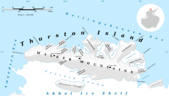
45:, an ice-covered, glacially dissected island, 215 km (134 mi) long, 90 km (56 mi) wide and 15,700 km (6,062 sq mi) in area, lying a short way off the northwest end of
361:
Peninsula, December 30, 1946. His energy and initiative contributed to the well-being of six survivors who were rescued Jan 12, 1947 (Ball
Peninsula, Mount Howell, q.v.).
2135:
2114:
2093:
2072:
2051:
2030:
2009:
1988:
1967:
1946:
1925:
1904:
1883:
1862:
1841:
1820:
1799:
1778:
1256:. A glacier 9 nautical miles (17 km; 10 mi) west of Long Glacier in southeast Thurston Island. It flows south along the east side of
231:
138:
1350:
1085:
759:
628:
581:
539:
328:
274:
517:. A glacier about 5 nautical miles (9.3 km; 5.8 mi) long, flowing from the east side of the Noville Peninsula into the west side of
171:
2183:
1123:
489:
802:
675:
2126:
2105:
2084:
2063:
2042:
2021:
2000:
1979:
1958:
1937:
1916:
1895:
1874:
1853:
1832:
1811:
1790:
2121:
2100:
2079:
2058:
2037:
2016:
1995:
1974:
1953:
1932:
1911:
1890:
1869:
1848:
1827:
1806:
1785:
1047:
1009:
971:
933:
895:
857:
1312:
1274:
1170:
721:
443:
385:
1228:
166:. Glacier about 4 nautical miles (7.4 km; 4.6 mi) long flowing north from the western end of Thurston Island just east of
78:
2173:
188:
2168:
2153:
2131:
2110:
2089:
2068:
2047:
2026:
2005:
1984:
1963:
1942:
1921:
1900:
1879:
1858:
1837:
1816:
1795:
178:(USGS), Reston, Virginia, computer specialist, team member of the Glaciological and Coastal-Change Maps of Antarctica Project.
175:
105:
100:
471:. Small glacier in the northeast part of Noville Peninsula. It flows east-northeast to Bellingshausen Sea between
95:
2178:
422:
303:
116:
90:
1257:
1215:
844:
430:
418:
1387:
414:
125:
788:
529:
Glacier to the east of
Noville Peninsula on the north side of the island, from west to east
378:
58:
1261:
704:
42:
1203:
62:
46:
2162:
1391:
1156:
661:
476:
260:
167:
1198:. A glacier in south-central Thurston Island; it flows south along the west side of
29:
1751:
1379:
1152:
831:
614:
568:
518:
1199:
708:
657:
472:
426:
357:
311:
217:
1383:
610:
307:
54:
50:
17:
1365:
1352:
1327:
1314:
1289:
1276:
1243:
1230:
1185:
1172:
1138:
1125:
1100:
1087:
1062:
1049:
1024:
1011:
986:
973:
948:
935:
910:
897:
872:
859:
817:
804:
774:
761:
736:
723:
690:
677:
643:
630:
596:
583:
554:
541:
504:
491:
458:
445:
400:
387:
343:
330:
289:
276:
246:
233:
203:
190:
153:
140:
315:
429:. First roughly delineated from air photos taken by United States Navy
310:
in north-central Thurston Island. The glacier enters the west part of
38:
115:
1155:
in central Thurston Island. The glacier flows south into
567:. A broad glacier flowing north into the southwest arm of
1759:(2 ed.), United States Board on Geographic Names
787:. A glacier flowing into the southwest extremity of
302:. A glacier flowing northeast from the vicinity of
707:, Thurston Island. It flows into the sea east of
1661:
1577:
1697:
1673:
1457:
1433:
1421:
1382:to the east end of Thurston Island. It enters
259:. A glacier flowing northeast into the head of
1685:
1517:
1493:
413:. Small glacier in the northeast part of the
1733:
1565:
1541:
1409:
1529:
1505:
1445:
8:
665:Island and adjacent coastal areas, 1946-47.
356:. A broad glacier flowing into the head of
2136:United States Department of the Interior
2115:United States Department of the Interior
2094:United States Department of the Interior
2073:United States Department of the Interior
2052:United States Department of the Interior
2031:United States Department of the Interior
2010:United States Department of the Interior
1989:United States Department of the Interior
1968:United States Department of the Interior
1947:United States Department of the Interior
1926:United States Department of the Interior
1905:United States Department of the Interior
1884:United States Department of the Interior
1863:United States Department of the Interior
1842:United States Department of the Interior
1821:United States Department of the Interior
1800:United States Department of the Interior
28:
1779:United States Board on Geographic Names
1721:
1709:
1649:
1637:
1625:
1613:
1601:
1589:
1553:
1481:
1469:
1402:
124:Glacier flowing north, to the west of
830:. A glacier flowing into the head of
618:and adjacent coastal areas, 1946-47.
216:. A glacier flowing into the head of
172:Advisory Committee on Antarctic Names
7:
53:. It is the third-largest island of
2127:Geographic Names Information System
2106:Geographic Names Information System
2085:Geographic Names Information System
2064:Geographic Names Information System
2043:Geographic Names Information System
2022:Geographic Names Information System
2001:Geographic Names Information System
1980:Geographic Names Information System
1959:Geographic Names Information System
1938:Geographic Names Information System
1917:Geographic Names Information System
1896:Geographic Names Information System
1875:Geographic Names Information System
1854:Geographic Names Information System
1833:Geographic Names Information System
1812:Geographic Names Information System
1791:Geographic Names Information System
1151:. A glacier whose head is east of
2152:from websites or documents of the
1777:from websites or documents of the
25:
1753:Geographic Names of the Antarctic
792:adjacent coastal areas, 1946-47.
703:. A glacier in the north part of
2148: This article incorporates
2143:
1773: This article incorporates
1768:
174:(US-ACAN) after Kevin M. Foley,
2154:United States Geological Survey
2132:United States Geological Survey
2111:United States Geological Survey
2090:United States Geological Survey
2069:United States Geological Survey
2048:United States Geological Survey
2027:United States Geological Survey
2006:United States Geological Survey
1985:United States Geological Survey
1964:United States Geological Survey
1943:United States Geological Survey
1922:United States Geological Survey
1901:United States Geological Survey
1880:United States Geological Survey
1859:United States Geological Survey
1838:United States Geological Survey
1817:United States Geological Survey
1796:United States Geological Survey
656:. A broad glacier flowing from
609:. A broad glacier flowing from
176:United States Geological Survey
120:Thurston Island in north of map
1750:Alberts, Fred G., ed. (1995),
170:. Named by the United States
1:
417:. It flows northeast to the
2184:Glaciers of Thurston Island
613:into the southeast arm of
106:GPX (secondary coordinates)
2200:
376:
247:72.0833333°S 100.0666667°W
154:71.9666667°S 101.1666667°W
1378:. A glacier flowing from
1366:72.4166667°S 96.0333333°W
1101:72.3166667°S 99.8833333°W
775:72.2666667°S 97.0333333°W
644:72.2333333°S 97.4333333°W
597:72.1666667°S 97.9166667°W
555:72.1833333°S 98.3166667°W
344:72.1666667°S 98.6833333°W
290:72.1166667°S 99.0666667°W
252:-72.0833333; -100.0666667
159:-71.9666667; -101.1666667
101:GPX (primary coordinates)
76:Map all coordinates using
2174:Antarctica-related lists
1371:-72.4166667; -96.0333333
1214:Glaciers to the east of
1106:-72.3166667; -99.8833333
843:Glaciers to the west of
780:-72.2666667; -97.0333333
649:-72.2333333; -97.4333333
602:-72.1666667; -97.9166667
560:-72.1833333; -98.3166667
349:-72.1666667; -98.6833333
295:-72.1166667; -99.0666667
84:Download coordinates as:
33:Map of Thurston Island.
2169:Glaciers of Antarctica
2150:public domain material
1775:public domain material
1662:Bellisime Glacier USGS
121:
34:
1578:Mahaffey Glacier USGS
1218:, from west to east:
847:, from west to east:
119:
96:GPX (all coordinates)
32:
1698:Hlubeck Glacier USGS
1674:Bearman Glacier USGS
1458:Robbins Glacier USGS
1434:Rexford Glacier USGS
1422:Sessums Glacier USGS
1139:72.35°S 99.1666667°W
505:71.95°S 98.3666667°W
437:Frankenfield Glacier
369:From north to south
128:, from west to east
1807:"Bellisime Glacier"
1686:Bulbur Glacier USGS
1518:Mincer Glacier USGS
1494:Pelter Glacier USGS
1362: /
1324: /
1286: /
1240: /
1182: /
1144:-72.35; -99.1666667
1135: /
1097: /
1059: /
1021: /
983: /
945: /
907: /
869: /
818:72.3°S 96.4333333°W
814: /
771: /
733: /
691:71.9166667°S 96.7°W
687: /
640: /
593: /
551: /
510:-71.95; -98.3666667
501: /
455: /
397: /
340: /
286: /
243: /
200: /
150: /
1954:"Mahaffey Glacier"
1734:Levko Glacier USGS
1566:Marck Glacier USGS
1542:Payne Glacier USGS
1410:Foley Glacier USGS
1216:Von der Wall Point
1063:72.233°S 100.300°W
1025:72.200°S 100.800°W
987:72.183°S 101.250°W
949:72.183°S 101.350°W
911:72.183°S 101.550°W
873:72.167°S 101.867°W
851:Kannheiser Glacier
845:Von der Wall Point
823:-72.3; -96.4333333
696:-71.9166667; -96.7
431:Operation Highjump
419:Bellingshausen Sea
122:
37:This is a list of
35:
2179:Lists of glaciers
2101:"Sessums Glacier"
2080:"Robbins Glacier"
2059:"Rexford Glacier"
1891:"Hlubeck Glacier"
1786:"Bearman Glacier"
1530:Goff Glacier USGS
1506:Warr Glacier USGS
1446:Litz Glacier USGS
1388:Tierney Peninsula
1328:72.417°S 96.083°W
1290:72.500°S 96.783°W
1079:Bellisime Glacier
1068:-72.233; -100.300
1030:-72.200; -100.800
992:-72.183; -101.250
954:-72.183; -101.350
916:-72.183; -101.550
878:-72.167; -101.867
737:71.967°S 96.333°W
660:into the head of
459:71.767°S 98.300°W
415:Noville Peninsula
401:71.733°S 98.500°W
365:Noville Peninsula
126:Noville Peninsula
16:(Redirected from
2191:
2147:
2146:
2138:
2117:
2096:
2075:
2054:
2038:"Pelter Glacier"
2033:
2012:
1996:"Mincer Glacier"
1991:
1970:
1949:
1928:
1907:
1886:
1865:
1844:
1828:"Bulbur Glacier"
1823:
1802:
1772:
1771:
1767:
1766:
1764:
1758:
1737:
1731:
1725:
1719:
1713:
1707:
1701:
1695:
1689:
1683:
1677:
1671:
1665:
1659:
1653:
1647:
1641:
1635:
1629:
1623:
1617:
1611:
1605:
1599:
1593:
1587:
1581:
1575:
1569:
1563:
1557:
1551:
1545:
1539:
1533:
1527:
1521:
1515:
1509:
1503:
1497:
1491:
1485:
1479:
1473:
1467:
1461:
1455:
1449:
1443:
1437:
1431:
1425:
1419:
1413:
1407:
1377:
1376:
1374:
1373:
1372:
1367:
1363:
1360:
1359:
1358:
1355:
1339:
1338:
1336:
1335:
1334:
1333:-72.417; -96.083
1329:
1325:
1322:
1321:
1320:
1317:
1301:
1300:
1298:
1297:
1296:
1295:-72.500; -96.783
1291:
1287:
1284:
1283:
1282:
1279:
1255:
1254:
1252:
1251:
1250:
1245:
1241:
1238:
1237:
1236:
1233:
1197:
1196:
1194:
1193:
1192:
1187:
1183:
1180:
1179:
1178:
1175:
1150:
1149:
1147:
1146:
1145:
1140:
1136:
1133:
1132:
1131:
1128:
1112:
1111:
1109:
1108:
1107:
1102:
1098:
1095:
1094:
1093:
1090:
1074:
1073:
1071:
1070:
1069:
1064:
1060:
1057:
1056:
1055:
1052:
1036:
1035:
1033:
1032:
1031:
1026:
1022:
1019:
1018:
1017:
1014:
998:
997:
995:
994:
993:
988:
984:
981:
980:
979:
976:
960:
959:
957:
956:
955:
950:
946:
943:
942:
941:
938:
922:
921:
919:
918:
917:
912:
908:
905:
904:
903:
900:
884:
883:
881:
880:
879:
874:
870:
867:
866:
865:
862:
829:
828:
826:
825:
824:
819:
815:
812:
811:
810:
807:
796:Mahaffey Glacier
789:Cadwalader Inlet
786:
785:
783:
782:
781:
776:
772:
769:
768:
767:
764:
748:
747:
745:
744:
743:
742:-71.967; -96.333
738:
734:
731:
730:
729:
726:
715:Deadmond Glacier
702:
701:
699:
698:
697:
692:
688:
685:
684:
683:
680:
655:
654:
652:
651:
650:
645:
641:
638:
637:
636:
633:
608:
607:
605:
604:
603:
598:
594:
591:
590:
589:
586:
566:
565:
563:
562:
561:
556:
552:
549:
548:
547:
544:
516:
515:
513:
512:
511:
506:
502:
499:
498:
497:
494:
470:
469:
467:
466:
465:
464:-71.767; -98.300
460:
456:
453:
452:
451:
448:
412:
411:
409:
408:
407:
406:-71.733; -98.500
402:
398:
395:
394:
393:
390:
379:Sikorski Glacier
373:Sikorski Glacier
355:
354:
352:
351:
350:
345:
341:
338:
337:
336:
333:
301:
300:
298:
297:
296:
291:
287:
284:
283:
282:
279:
258:
257:
255:
254:
253:
248:
244:
241:
240:
239:
236:
215:
214:
212:
211:
210:
205:
201:
198:
197:
196:
193:
165:
164:
162:
161:
160:
155:
151:
148:
147:
146:
143:
59:Alexander Island
21:
2199:
2198:
2194:
2193:
2192:
2190:
2189:
2188:
2159:
2158:
2144:
2141:
2120:
2099:
2078:
2057:
2036:
2017:"Payne Glacier"
2015:
1994:
1975:"Marck Glacier"
1973:
1952:
1931:
1912:"Levko Glacier"
1910:
1889:
1868:
1849:"Foley Glacier"
1847:
1826:
1805:
1784:
1769:
1762:
1760:
1756:
1749:
1745:
1740:
1732:
1728:
1720:
1716:
1708:
1704:
1696:
1692:
1684:
1680:
1672:
1668:
1660:
1656:
1648:
1644:
1636:
1632:
1624:
1620:
1612:
1608:
1600:
1596:
1588:
1584:
1576:
1572:
1564:
1560:
1552:
1548:
1540:
1536:
1528:
1524:
1516:
1512:
1504:
1500:
1492:
1488:
1480:
1476:
1468:
1464:
1456:
1452:
1444:
1440:
1432:
1428:
1420:
1416:
1408:
1404:
1400:
1370:
1368:
1364:
1361:
1356:
1353:
1351:
1349:
1348:
1346:
1332:
1330:
1326:
1323:
1318:
1315:
1313:
1311:
1310:
1308:
1294:
1292:
1288:
1285:
1280:
1277:
1275:
1273:
1272:
1270:
1262:Abbot Ice Shelf
1248:
1246:
1242:
1239:
1234:
1231:
1229:
1227:
1226:
1224:
1222:Hlubeck Glacier
1212:
1210:Southeast coast
1190:
1188:
1186:72.45°S 98.55°W
1184:
1181:
1176:
1173:
1171:
1169:
1168:
1166:
1143:
1141:
1137:
1134:
1129:
1126:
1124:
1122:
1121:
1119:
1117:Bearman Glacier
1105:
1103:
1099:
1096:
1091:
1088:
1086:
1084:
1083:
1081:
1067:
1065:
1061:
1058:
1053:
1050:
1048:
1046:
1045:
1043:
1029:
1027:
1023:
1020:
1015:
1012:
1010:
1008:
1007:
1005:
991:
989:
985:
982:
977:
974:
972:
970:
969:
967:
953:
951:
947:
944:
939:
936:
934:
932:
931:
929:
927:Rochray Glacier
915:
913:
909:
906:
901:
898:
896:
894:
893:
891:
877:
875:
871:
868:
863:
860:
858:
856:
855:
853:
841:
839:Southwest coast
822:
820:
816:
813:
808:
805:
803:
801:
800:
798:
779:
777:
773:
770:
765:
762:
760:
758:
757:
755:
741:
739:
735:
732:
727:
724:
722:
720:
719:
717:
705:Evans Peninsula
695:
693:
689:
686:
681:
678:
676:
674:
673:
671:
648:
646:
642:
639:
634:
631:
629:
627:
626:
624:
601:
599:
595:
592:
587:
584:
582:
580:
579:
577:
559:
557:
553:
550:
545:
542:
540:
538:
537:
535:
527:
509:
507:
503:
500:
495:
492:
490:
488:
487:
485:
463:
461:
457:
454:
449:
446:
444:
442:
441:
439:
405:
403:
399:
396:
391:
388:
386:
384:
383:
381:
375:
367:
348:
346:
342:
339:
334:
331:
329:
327:
326:
324:
322:Robbins Glacier
294:
292:
288:
285:
280:
277:
275:
273:
272:
270:
251:
249:
245:
242:
237:
234:
232:
230:
229:
227:
225:Rexford Glacier
208:
206:
202:
199:
194:
191:
189:
187:
186:
184:
182:Sessums Glacier
158:
156:
152:
149:
144:
141:
139:
137:
136:
134:
114:
113:
112:
111:
110:
71:
43:Thurston Island
23:
22:
15:
12:
11:
5:
2197:
2195:
2187:
2186:
2181:
2176:
2171:
2161:
2160:
2140:
2139:
2122:"Warr Glacier"
2118:
2097:
2076:
2055:
2034:
2013:
1992:
1971:
1950:
1933:"Litz Glacier"
1929:
1908:
1887:
1870:"Goff Glacier"
1866:
1845:
1824:
1803:
1782:
1746:
1744:
1741:
1739:
1738:
1726:
1724:, p. 650.
1714:
1712:, p. 442.
1702:
1690:
1678:
1666:
1654:
1652:, p. 514.
1642:
1640:, p. 305.
1630:
1628:, p. 158.
1618:
1616:, p. 625.
1606:
1604:, p. 159.
1594:
1592:, p. 382.
1582:
1570:
1558:
1556:, p. 178.
1546:
1534:
1522:
1510:
1498:
1486:
1484:, p. 257.
1474:
1472:, p. 675.
1462:
1450:
1438:
1426:
1414:
1401:
1399:
1396:
1345:
1342:
1307:
1306:Savage Glacier
1304:
1269:
1266:
1244:72.5°S 97.15°W
1223:
1220:
1211:
1208:
1191:-72.45; -98.55
1165:
1164:Bulbur Glacier
1162:
1118:
1115:
1080:
1077:
1042:
1039:
1004:
1001:
966:
963:
928:
925:
890:
887:
852:
849:
840:
837:
797:
794:
754:
751:
716:
713:
670:
667:
623:
620:
576:
575:Mincer Glacier
573:
534:
531:
526:
523:
484:
483:Pelter Glacier
481:
438:
435:
377:Main article:
374:
371:
366:
363:
323:
320:
269:
266:
226:
223:
183:
180:
133:
130:
109:
108:
103:
98:
93:
87:
81:
74:
73:
72:
70:
67:
63:Berkner Island
47:Ellsworth Land
24:
18:Bulbur Glacier
14:
13:
10:
9:
6:
4:
3:
2:
2196:
2185:
2182:
2180:
2177:
2175:
2172:
2170:
2167:
2166:
2164:
2157:
2155:
2151:
2137:
2133:
2129:
2128:
2123:
2119:
2116:
2112:
2108:
2107:
2102:
2098:
2095:
2091:
2087:
2086:
2081:
2077:
2074:
2070:
2066:
2065:
2060:
2056:
2053:
2049:
2045:
2044:
2039:
2035:
2032:
2028:
2024:
2023:
2018:
2014:
2011:
2007:
2003:
2002:
1997:
1993:
1990:
1986:
1982:
1981:
1976:
1972:
1969:
1965:
1961:
1960:
1955:
1951:
1948:
1944:
1940:
1939:
1934:
1930:
1927:
1923:
1919:
1918:
1913:
1909:
1906:
1902:
1898:
1897:
1892:
1888:
1885:
1881:
1877:
1876:
1871:
1867:
1864:
1860:
1856:
1855:
1850:
1846:
1843:
1839:
1835:
1834:
1829:
1825:
1822:
1818:
1814:
1813:
1808:
1804:
1801:
1797:
1793:
1792:
1787:
1783:
1780:
1776:
1755:
1754:
1748:
1747:
1742:
1735:
1730:
1727:
1723:
1718:
1715:
1711:
1706:
1703:
1699:
1694:
1691:
1687:
1682:
1679:
1675:
1670:
1667:
1663:
1658:
1655:
1651:
1646:
1643:
1639:
1634:
1631:
1627:
1622:
1619:
1615:
1610:
1607:
1603:
1598:
1595:
1591:
1586:
1583:
1579:
1574:
1571:
1567:
1562:
1559:
1555:
1550:
1547:
1543:
1538:
1535:
1531:
1526:
1523:
1519:
1514:
1511:
1507:
1502:
1499:
1495:
1490:
1487:
1483:
1478:
1475:
1471:
1466:
1463:
1459:
1454:
1451:
1447:
1442:
1439:
1435:
1430:
1427:
1423:
1418:
1415:
1411:
1406:
1403:
1397:
1395:
1393:
1392:Simpson Bluff
1389:
1385:
1381:
1375:
1344:Levko Glacier
1343:
1341:
1337:
1305:
1303:
1299:
1267:
1265:
1263:
1259:
1253:
1249:-72.5; -97.15
1221:
1219:
1217:
1209:
1207:
1205:
1201:
1195:
1163:
1161:
1158:
1157:Schwartz Cove
1154:
1148:
1116:
1114:
1110:
1078:
1076:
1072:
1041:Myers Glacier
1040:
1038:
1034:
1002:
1000:
996:
964:
962:
958:
926:
924:
920:
889:Craft Glacier
888:
886:
882:
850:
848:
846:
838:
836:
833:
827:
795:
793:
790:
784:
753:Marck Glacier
752:
750:
746:
714:
712:
710:
706:
700:
669:Payne Glacier
668:
666:
663:
662:Koether Inlet
659:
653:
621:
619:
616:
612:
606:
574:
572:
570:
564:
532:
530:
524:
522:
520:
514:
482:
480:
478:
477:Mulroy Island
474:
468:
436:
434:
432:
428:
424:
420:
416:
410:
380:
372:
370:
364:
362:
359:
353:
321:
319:
317:
313:
309:
305:
299:
267:
265:
262:
261:Wagoner Inlet
256:
224:
222:
219:
213:
204:72°S 100.55°W
181:
179:
177:
173:
169:
168:Cape Petersen
163:
132:Foley Glacier
131:
129:
127:
118:
107:
104:
102:
99:
97:
94:
92:
89:
88:
86:
85:
80:
79:OpenStreetMap
77:
68:
66:
64:
60:
56:
52:
48:
44:
40:
31:
27:
19:
2142:
2125:
2104:
2083:
2062:
2041:
2020:
1999:
1978:
1957:
1936:
1915:
1894:
1873:
1852:
1831:
1810:
1789:
1761:, retrieved
1752:
1729:
1722:Alberts 1995
1717:
1710:Alberts 1995
1705:
1693:
1681:
1669:
1657:
1650:Alberts 1995
1645:
1638:Alberts 1995
1633:
1626:Alberts 1995
1621:
1614:Alberts 1995
1609:
1602:Alberts 1995
1597:
1590:Alberts 1995
1585:
1573:
1561:
1554:Alberts 1995
1549:
1537:
1525:
1513:
1501:
1489:
1482:Alberts 1995
1477:
1470:Alberts 1995
1465:
1453:
1441:
1429:
1417:
1405:
1380:Pallid Crest
1347:
1309:
1271:
1268:Long Glacier
1258:Shelton head
1225:
1213:
1167:
1153:Mount Howell
1120:
1082:
1044:
1006:
1003:Hale Glacier
968:
930:
892:
854:
842:
832:Morgan Inlet
799:
756:
718:
672:
625:
622:Goff Glacier
615:Murphy Inlet
578:
569:Murphy Inlet
536:
533:Warr Glacier
528:
519:Murphy Inlet
486:
440:
423:Mount Palmer
382:
368:
325:
271:
268:Litz Glacier
228:
209:-72; -100.55
185:
135:
123:
83:
82:
75:
36:
26:
1369: /
1331: /
1293: /
1247: /
1204:O'Dowd Cove
1200:Boker Rocks
1189: /
1142: /
1104: /
1066: /
1028: /
990: /
965:Cox Clacier
952: /
914: /
876: /
821: /
778: /
740: /
709:Cape Walden
694: /
658:Parker Peak
647: /
600: /
558: /
508: /
473:Mount Feury
462: /
427:Mount Feury
404: /
358:Peale Inlet
347: /
312:Peale Inlet
293: /
250: /
238:100°04′00″W
218:Henry Inlet
207: /
157: /
145:101°10′00″W
2163:Categories
1763:3 December
1398:References
1384:Seraph Bay
1357:96°02′00″W
1354:72°25′00″S
1130:99°10′00″W
1127:72°21′00″S
1092:99°53′00″W
1089:72°19′00″S
809:96°26′00″W
806:72°18′00″S
766:97°02′00″W
763:72°16′00″S
682:96°42′00″W
679:71°55′00″S
635:97°26′00″W
632:72°14′00″S
611:Zuhn Bluff
588:97°55′00″W
585:72°10′00″S
546:98°19′00″W
543:72°11′00″S
496:98°22′00″W
493:71°57′00″S
335:98°41′00″W
332:72°10′00″S
308:Litz Bluff
304:Smith Peak
281:99°04′00″W
278:72°07′00″S
235:72°05′00″S
142:71°58′00″S
55:Antarctica
51:Antarctica
835:1946-47.
525:Northeast
316:Guy Peaks
314:north of
69:Northwest
1386:between
1054:100°18′W
1016:100°48′W
978:101°15′W
940:101°21′W
902:101°33′W
864:101°52′W
421:between
195:100°33′W
57:, after
39:glaciers
1743:Sources
1319:96°05′W
1316:72°25′S
1281:96°47′W
1278:72°30′S
1235:97°09′W
1232:72°30′S
1177:98°33′W
1174:72°27′S
1051:72°14′S
1013:72°12′S
975:72°11′S
937:72°11′S
899:72°11′S
861:72°10′S
728:96°20′W
725:71°58′S
450:98°18′W
447:71°46′S
392:98°30′W
389:71°44′S
192:72°00′S
1757:(PDF)
1260:into
1202:into
1765:2023
1390:and
475:and
425:and
306:and
65:.
61:and
91:KML
41:on
2165::
2156:.
2134:,
2130:,
2124:,
2113:,
2109:,
2103:,
2092:,
2088:,
2082:,
2071:,
2067:,
2061:,
2050:,
2046:,
2040:,
2029:,
2025:,
2019:,
2008:,
2004:,
1998:,
1987:,
1983:,
1977:,
1966:,
1962:,
1956:,
1945:,
1941:,
1935:,
1924:,
1920:,
1914:,
1903:,
1899:,
1893:,
1882:,
1878:,
1872:,
1861:,
1857:,
1851:,
1840:,
1836:,
1830:,
1819:,
1815:,
1809:,
1798:,
1794:,
1788:,
49:,
1781:.
1736:.
1700:.
1688:.
1676:.
1664:.
1580:.
1568:.
1544:.
1532:.
1520:.
1508:.
1496:.
1460:.
1448:.
1436:.
1424:.
1412:.
20:)
Text is available under the Creative Commons Attribution-ShareAlike License. Additional terms may apply.