244:
121:
217:
235:
24:
226:
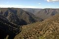
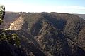
154:. Besides caving, it is used for bushwalking, camping, and other adventure activities. A nearby lookout, known as "The Lookdown", has views of the Shoalhaven River, Bungonia Gorge and Bungonia Creek.
199:
194:
164:
The appearance of the area is currently marred by the presence of an adjoining limestone quarry. The quarry is to cease operations by 2011, followed by site remediation.
41:
253:
292:
88:
60:
297:
67:
107:
74:
45:
56:
210:
Some views from
Bungonia lookdown, New South Wales, Australia. The limestone quarry is visible in the fourth image.
179:
139:
The SRA is about 35 kilometres (22 mi) east of
Goulburn and about 125 kilometres (78 mi) south-west of
133:
81:
34:
144:
243:
151:
286:
234:
216:
120:
23:
225:
180:
https://www.nationalparks.nsw.gov.au/visit-a-park/parks/bungonia-national-park
268:
255:
158:
140:
119:
17:
161:
can be found along the various walking tracks in the area.
48:. Unsourced material may be challenged and removed.
150:The area features dramatic cliffs, gorges and a
8:
132:(SRA) is a nature reserve near the city of
108:Learn how and when to remove this message
212:
172:
7:
46:adding citations to reliable sources
293:Protected areas of New South Wales
14:
242:
233:
224:
215:
57:"Bungonia State Recreation Area"
22:
124:View from the Bungonia Lookdown
33:needs additional citations for
195:Bungonia State Recreation Area
130:Bungonia State Recreation Area
1:
314:
298:Goulburn Mulwaree Council
134:Goulburn, New South Wales
182:|Bungonia National Park
269:34.79528°S 150.01389°E
125:
143:, and it adjoins the
123:
274:-34.79528; 150.01389
200:Morton National Park
145:Morton National Park
42:improve this article
265: /
126:
118:
117:
110:
92:
305:
280:
279:
277:
276:
275:
270:
266:
263:
262:
261:
258:
246:
237:
228:
219:
183:
177:
152:network of caves
113:
106:
102:
99:
93:
91:
50:
26:
18:
313:
312:
308:
307:
306:
304:
303:
302:
283:
282:
273:
271:
267:
264:
259:
256:
254:
252:
251:
247:
238:
229:
220:
208:
191:
186:
178:
174:
170:
114:
103:
97:
94:
51:
49:
39:
27:
12:
11:
5:
311:
309:
301:
300:
295:
285:
284:
249:
248:
241:
239:
232:
230:
223:
221:
214:
207:
204:
203:
202:
197:
190:
189:External links
187:
185:
184:
171:
169:
166:
116:
115:
30:
28:
21:
13:
10:
9:
6:
4:
3:
2:
310:
299:
296:
294:
291:
290:
288:
281:
278:
245:
240:
236:
231:
227:
222:
218:
213:
211:
205:
201:
198:
196:
193:
192:
188:
181:
176:
173:
167:
165:
162:
160:
155:
153:
148:
146:
142:
137:
135:
131:
122:
112:
109:
101:
90:
87:
83:
80:
76:
73:
69:
66:
62:
59: –
58:
54:
53:Find sources:
47:
43:
37:
36:
31:This article
29:
25:
20:
19:
16:
250:
209:
175:
163:
156:
149:
138:
129:
127:
104:
98:January 2011
95:
85:
78:
71:
64:
52:
40:Please help
35:verification
32:
15:
272: /
260:150°00′50″E
136:Australia.
287:Categories
257:34°47′43″S
168:References
68:newspapers
206:Gallery
159:fossils
82:scholar
141:Sydney
84:
77:
70:
63:
55:
157:Many
89:JSTOR
75:books
128:The
61:news
44:by
289::
147:.
111:)
105:(
100:)
96:(
86:·
79:·
72:·
65:·
38:.
Text is available under the Creative Commons Attribution-ShareAlike License. Additional terms may apply.