521:
455:
53:
408:. The sewer has two sections: one starts at Lawrence Avenue and follows the old Burke Brooke, and the other starts at Douglass Avenue and Bathurst Street. The North Toronto Storm Trunk Sewer was a Metropolitan Toronto project installed during the 1960s and 70s. Like other sewers build at that time, it was intended to help reduce sewage along the planned route for the
412:. It was also intended to allow particle sewage separation in suburban boroughs served by smaller sewage plants and to open up more land for development. The sewer also links to the North York Storm Trunk Sewer by Douglass Avenue and Bathurst Street. The North Toronto Storm Trunk Sewer meets the Burke Brooke where it starts near Glenview Senior Public School
60:
438:
then headed to the point where it met the McDougall Stream, then it continued to the east side of Yonge Street to meet the Burke Brook near Yonge Street and Saint
Edmunds Drive. The McDougall stream started just north of the Blythwood Stream and curved north and west to where it met the Lawrence Park Stream.
379:
Havergal Stream runs entirely through the property of
Havergal College girls' school. The start of the stream is fed by local sewers and nearby springs. The Havergal Stream then proceeds to meet the North Toronto Storm Trunk Sewer at the edge of the school property. The water of the stream flows into
437:
Lawrence Park Stream merged with the McDougall Stream by the Locke
Library between Lawrence and Lympstone. The length of the Lawrence Park stream was 6 kilometres (3.7 mi) and the McDougall Stream was 1 kilometre (0.62 mi). The Lawrence Park Stream started by Wilson Avenue and Avenue Road,
383:
Havergal Stream used to start under the intersection of Old
Orchard Grove and Barse Street by the Baycrest Hospital. The length of the river was 1.5 kilometres (0.93 mi). The river left its source and proceeded in a south-south-east direction to the current grounds of Havergal College, where
511:
Blythwood Ravine Park is a ravine between
Alexander Muir Memorial Gardens and Blythwood Road. It also has entrances and the end of Strathgowan Avenue and Glengowan Road. The park is quite skinny and acts as a connector park between Sherwood park and Alexander Muir Memorial Gardens/ Yonge Street.
428:
Blythwood Stream, which started by
Glengowan Road and Strathgowan and also at Saint Leonards Avenue and Saint Ives Avenue. It is the closest tributary to the Don River. The two section merged at Strathgowan Road and Fidelia Avenue. The stream followed a course running just east of Blythdale Road
534:
This park is between
Blythwood Ravine Park and Yonge Street. It contains the tennis courts of the Lawrence Park Tennis Club and the fields of the Lawrence Park Lawn Bowling and Croquet Club. The main attraction of the park is the song The Maple Leaf Forever, a patriotic song about Canada, by
535:
Alexander Muir, printed on a stone wall with stairs connected to the fields and gardens of the park. The park was originally located on the west side of Yonge Street across from the Mount
Pleasant Cemetery to celebrate the Toronto centennial celebrations. To build the
551:
Duplex
Parkette is located between Yonge Street and Duplex Avenue south of Chatsworth Drive. Burke Brooke runs in underground pipes through the entirety of the park. Just south of Duplex Parkette is Glenview Parkette. A small part consisting of two small
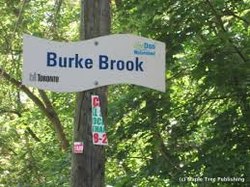
498:
Sherwood Park is a park in
Toronto. It contains a city maintenance building, a water park, a playground, and washrooms. It contains 2 paths to the left and right of the Burke Brook. It contains a dog-off-leash park to the south-east north of the
40:
472:
from the west. It is home to the Sunnybrook Stables, dog parks, and many sport fields. There are also many bike and walking paths, with a few car-accessible roads scattered throughout. The park is also known for its cricket.
481:
The Burke Brook Ravine is a ravine that stretches from Sunnybrook Park to Bayview Avenue. The ravine has no official trail connection to Bayview Avenue but is accessible from Bayview Avenue by steeply sloping paths.
362:. The stream then went in a southeast direction to where it met the beginning of the stream today (just east of Glenview Senior Public School). After that the stream followed the current course to where it meets the
564:
Chatsworth is a ravine between Duplex Avenue and Glenview Senior Public School with a path running to Cheritan Avenue. It has a bridge in the middle moving the path from south of the river to north of the river.
821:
490:
Sunnydene Park is a small park just to the east of Sherwood Park, to the west of Bayview Avenue. The park is near Sherwood Park and maps include it as part of Sherwood Park
384:
nowadays it pops ups from the ground. The stream then went to where the current North Toronto Storm Trunk Sewer is and then met the Burke Brook a little east of there.
870:
807:
1003:
503:
and west of Sunnydene Park. To the north of the park is Blythwood Road and the Blythwood Ravine. A road leads west out of the park to Sherwood Avenue.
239:
996:
529:
347:
143:
1178:
500:
536:
161:
366:. The total length of the stream was 9 kilometres (5.6 mi), with 6 kilometres (3.7 mi) being tributaries.
1173:
989:
540:
52:
1067:
1057:
520:
1112:
1082:
1016:
1142:
1077:
885:
846:
543:
paid over $ 100,000 to move the park, including the stone wall, to its current location in Lawrence Park.
429:
almost parallel until it met Burke Brook. The length of the stream was around 1 kilometre (0.62 mi).
783:
1107:
1102:
1032:
1012:
104:
1132:
1097:
1071:
1047:
590:
469:
363:
339:
301:
212:
1062:
1042:
981:
602:
Duplex Avenue - No traffic lights (Glenview Avenue has closest pedestrian crossings (stop sign))
710:
454:
1137:
864:
801:
359:
1117:
758:
1087:
1052:
463:
420:
The Burke Brook used to have a total of 6 kilometres (3.7 mi) of tributary streams.
1122:
577:
295:
1167:
1147:
734:
581:
553:
1127:
1092:
657:
596:
343:
524:
The wall with the song Maple Leaf Forever on it at Alexander Muir Memorial Gardens
17:
686:
1027:
599:- No traffic/ pedestrian lights (Saint Edmunds Drive has closest traffic lights)
393:
207:
909:
409:
397:
254:
241:
176:
163:
1151:
380:
the North Toronto Storm Trunk Sewer, where the sewer meets the Burke Brook.
405:
401:
335:
331:
114:
94:
933:
39:
225:
147:
84:
957:
519:
453:
468:
Sunnybrook Park is a major park in Toronto that connects to the
985:
630:
580:- No traffic/pedestrian lights (Kilgour Road has the closest
784:"Parks, Forestry and Recreation : Sunnybrook Park"
958:"Lawrence Park Tennis Club | Lawrence Park Tennis Club"
711:"North Toronto Storm Trunk Sewer | Vanishing Point"
315:
307:
293:
288:
280:
270:
231:
218:
206:
192:
153:
137:
129:
120:
110:
100:
90:
80:
75:
32:
997:
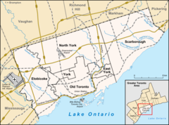
67:Location of the mouth of the creek in Toronto
8:
869:: CS1 maint: multiple names: authors list (
806:: CS1 maint: multiple names: authors list (
587:Blythwood Road - Pedestrian crossing lights
342:watershield, a major river that flows into
1004:
990:
982:
346:. The north end of the stream begins near
845:Recreation, Toronto Parks, Forestry and.
782:Recreation, Toronto Parks, Forestry and.
392:The North Toronto Storm Trunk Sewer is a
611:
862:
799:
446:Parks are in order from east to west.
29:
652:
650:
7:
681:
679:
677:
625:
623:
621:
619:
617:
615:
556:with pathways running through them.
59:
25:
910:"Alexander Muir Memorial Gardens"
547:Duplex Parkette/Glenview Parkette
358:Burke Brooke used to start near
58:
51:
38:
530:Alexander Muir Memorial Gardens
516:Alexander Muir Memorial Gardens
388:North Toronto Storm Trunk Sewer
321:North Toronto Storm Trunk Sewer
233: • coordinates
155: • coordinates
1:
348:Glenview Senior Public School
144:Glenview Senior Public School
121:Physical characteristics
573:In order from east to west:
501:Mount Hope Catholic Cemetery
272: • elevation
194: • elevation
220: • location
139: • location
1195:
593:- path goes under a bridge
527:
461:
1023:
962:lawrenceparktennisclub.ca
202:
125:
46:
37:
276:134 m (440 ft)
198:178 m (584 ft)
27:River in Ontario, Canada
1017:Toronto waterway system
317: • left
284:9 km (5.6 mi)
255:43.720586°N 79.365653°W
177:43.720583°N 79.408013°W
759:"Lawrence Park Stream"
525:
459:
1013:Toronto ravine system
715:www.vanishingpoint.ca
523:
507:Blythwood Ravine Park
457:
330:is a small stream in
260:43.720586; -79.365653
182:43.720583; -79.408013
822:"311 Knowledge Base"
433:Lawrence Park Stream
338:. It is part of the
105:Greater Toronto Area
1179:Don River (Ontario)
1133:Taylor-Massey Creek
1072:West Highland Creek
591:Mount Pleasant Road
289:Basin features
251: /
173: /
1063:German Mills Creek
1043:Castle Frank Brook
890:www.chebucto.ns.ca
886:"mapleleafforever"
735:"Blythwood Stream"
526:
477:Burke Brook Ravine
460:
416:Former tributaries
410:Spadina Expressway
18:Burke's Brook
1174:Rivers of Toronto
1161:
1160:
914:www.lostrivers.ca
763:www.lostrivers.ca
739:www.lostrivers.ca
691:www.lostrivers.ca
687:"Havergal Stream"
662:www.lostrivers.ca
560:Chatsworth Ravine
360:Downsview Airport
325:
324:
224:Sunnybrook Park,
16:(Redirected from
1186:
1006:
999:
992:
983:
972:
971:
969:
968:
954:
948:
947:
945:
944:
930:
924:
923:
921:
920:
906:
900:
899:
897:
896:
881:
875:
874:
868:
860:
858:
857:
842:
836:
835:
833:
832:
818:
812:
811:
805:
797:
795:
794:
779:
773:
772:
770:
769:
755:
749:
748:
746:
745:
731:
725:
724:
722:
721:
707:
701:
700:
698:
697:
683:
672:
671:
669:
668:
654:
645:
644:
642:
641:
627:
569:Street crossings
424:Blythwood Stream
318:
298:
266:
265:
263:
262:
261:
256:
252:
249:
248:
247:
244:
195:
188:
187:
185:
184:
183:
178:
174:
171:
170:
169:
166:
156:
140:
62:
61:
55:
42:
30:
21:
1194:
1193:
1189:
1188:
1187:
1185:
1184:
1183:
1164:
1163:
1162:
1157:
1088:Keating Channel
1053:Etobicoke Creek
1019:
1010:
980:
975:
966:
964:
956:
955:
951:
942:
940:
934:"Lawrence Park"
932:
931:
927:
918:
916:
908:
907:
903:
894:
892:
883:
882:
878:
861:
855:
853:
851:City of Toronto
847:"Sherwood Park"
844:
843:
839:
830:
828:
820:
819:
815:
798:
792:
790:
781:
780:
776:
767:
765:
757:
756:
752:
743:
741:
733:
732:
728:
719:
717:
709:
708:
704:
695:
693:
685:
684:
675:
666:
664:
656:
655:
648:
639:
637:
629:
628:
613:
609:
571:
562:
549:
532:
518:
509:
496:
488:
479:
466:
464:Sunnybrook Park
458:Sunnybrook Park
452:
450:Sunnybrook Park
444:
435:
426:
418:
390:
377:
375:Havergal Stream
372:
356:
316:
294:
273:
259:
257:
253:
250:
245:
242:
240:
238:
237:
234:
221:
193:
181:
179:
175:
172:
167:
164:
162:
160:
159:
154:
138:
71:
70:
69:
68:
65:
64:
63:
28:
23:
22:
15:
12:
11:
5:
1192:
1190:
1182:
1181:
1176:
1166:
1165:
1159:
1158:
1156:
1155:
1145:
1140:
1138:Tomlin's Creek
1135:
1130:
1125:
1123:Superior Creek
1120:
1115:
1110:
1105:
1100:
1095:
1090:
1085:
1080:
1075:
1068:Highland Creek
1065:
1060:
1058:Garrison Creek
1055:
1050:
1045:
1040:
1035:
1030:
1024:
1021:
1020:
1011:
1009:
1008:
1001:
994:
986:
979:
978:External links
976:
974:
973:
949:
925:
901:
884:Cumming, Don.
876:
837:
826:www.toronto.ca
813:
788:www.toronto.ca
774:
750:
726:
702:
673:
646:
610:
608:
605:
604:
603:
600:
594:
588:
585:
578:Bayview Avenue
570:
567:
561:
558:
554:flower gardens
548:
545:
528:Main article:
517:
514:
508:
505:
495:
492:
487:
486:Sunnydene Park
484:
478:
475:
462:Main article:
451:
448:
443:
440:
434:
431:
425:
422:
417:
414:
389:
386:
376:
373:
371:
368:
364:West Don River
355:
352:
323:
322:
319:
313:
312:
309:
305:
304:
299:
291:
290:
286:
285:
282:
278:
277:
274:
271:
268:
267:
235:
232:
229:
228:
222:
219:
216:
215:
210:
204:
203:
200:
199:
196:
190:
189:
157:
151:
150:
141:
135:
134:
131:
127:
126:
123:
122:
118:
117:
112:
108:
107:
102:
98:
97:
92:
88:
87:
82:
78:
77:
73:
72:
66:
57:
56:
50:
49:
48:
47:
44:
43:
35:
34:
26:
24:
14:
13:
10:
9:
6:
4:
3:
2:
1191:
1180:
1177:
1175:
1172:
1171:
1169:
1153:
1149:
1148:Wendigo Creek
1146:
1144:
1141:
1139:
1136:
1134:
1131:
1129:
1126:
1124:
1121:
1119:
1118:Small's Creek
1116:
1114:
1113:Russell Creek
1111:
1109:
1106:
1104:
1101:
1099:
1096:
1094:
1091:
1089:
1086:
1084:
1083:Jackson Creek
1081:
1079:
1076:
1073:
1069:
1066:
1064:
1061:
1059:
1056:
1054:
1051:
1049:
1046:
1044:
1041:
1039:
1036:
1034:
1031:
1029:
1026:
1025:
1022:
1018:
1014:
1007:
1002:
1000:
995:
993:
988:
987:
984:
977:
963:
959:
953:
950:
939:
938:Lawrence Park
935:
929:
926:
915:
911:
905:
902:
891:
887:
880:
877:
872:
866:
852:
848:
841:
838:
827:
823:
817:
814:
809:
803:
789:
785:
778:
775:
764:
760:
754:
751:
740:
736:
730:
727:
716:
712:
706:
703:
692:
688:
682:
680:
678:
674:
663:
659:
658:"Burke Brook"
653:
651:
647:
636:
632:
631:"Google Maps"
626:
624:
622:
620:
618:
616:
612:
606:
601:
598:
595:
592:
589:
586:
583:
582:Traffic light
579:
576:
575:
574:
568:
566:
559:
557:
555:
546:
544:
542:
538:
531:
522:
515:
513:
506:
504:
502:
494:Sherwood Park
493:
491:
485:
483:
476:
474:
471:
465:
456:
449:
447:
441:
439:
432:
430:
423:
421:
415:
413:
411:
407:
403:
399:
395:
387:
385:
381:
374:
369:
367:
365:
361:
353:
351:
349:
345:
341:
337:
333:
329:
320:
314:
310:
306:
303:
300:
297:
292:
287:
283:
279:
275:
269:
264:
236:
230:
227:
223:
217:
214:
211:
209:
205:
201:
197:
191:
186:
158:
152:
149:
145:
142:
136:
132:
128:
124:
119:
116:
113:
109:
106:
103:
99:
96:
93:
89:
86:
83:
79:
74:
54:
45:
41:
36:
31:
19:
1152:Spring Creek
1143:Yellow Creek
1128:Taddle Creek
1093:Mimico Creek
1078:Humber River
1037:
965:. Retrieved
961:
952:
941:. Retrieved
937:
928:
917:. Retrieved
913:
904:
893:. Retrieved
889:
879:
854:. Retrieved
850:
840:
829:. Retrieved
825:
816:
791:. Retrieved
787:
777:
766:. Retrieved
762:
753:
742:. Retrieved
738:
729:
718:. Retrieved
714:
705:
694:. Retrieved
690:
665:. Retrieved
661:
638:. Retrieved
634:
597:Yonge Street
572:
563:
550:
537:Yonge Subway
533:
510:
497:
489:
480:
467:
445:
436:
427:
419:
396:location in
391:
382:
378:
357:
344:Lake Ontario
327:
326:
296:River system
1108:Rouge River
1103:North Creek
1038:Burke Brook
1033:Black Creek
1028:Bonar Creek
635:Google Maps
394:storm sewer
370:Tributaries
328:Burke Brook
308:Tributaries
258: /
180: /
33:Burke Brook
1168:Categories
967:2017-12-06
943:2017-12-06
919:2017-12-06
895:2017-12-06
856:2019-03-30
831:2017-12-06
793:2017-12-06
768:2017-12-06
744:2017-12-06
720:2017-12-06
696:2017-12-06
667:2017-12-05
640:2017-03-06
607:References
470:Don Valley
398:North York
246:79°21′56″W
243:43°43′14″N
168:79°24′29″W
165:43°43′14″N
1098:Mud Creek
1048:Don River
340:Don River
302:Don River
213:Don River
865:cite web
802:cite web
76:Location
406:Ontario
402:Toronto
354:History
336:Ontario
332:Toronto
115:Toronto
95:Ontario
81:Country
311:
281:Length
226:Canada
148:Canada
133:
130:Source
101:Region
85:Canada
442:Parks
208:Mouth
91:State
871:link
808:link
539:the
111:City
541:TTC
1170::
960:.
936:.
912:.
888:.
867:}}
863:{{
849:.
824:.
804:}}
800:{{
786:.
761:.
737:.
713:.
689:.
676:^
660:.
649:^
633:.
614:^
404:,
400:,
350:.
334:,
146:,
1154:)
1150:(
1074:)
1070:(
1015:/
1005:e
998:t
991:v
970:.
946:.
922:.
898:.
873:)
859:.
834:.
810:)
796:.
771:.
747:.
723:.
699:.
670:.
643:.
584:)
20:)
Text is available under the Creative Commons Attribution-ShareAlike License. Additional terms may apply.