206:
184:
977:
74:
115:
175:. There is a bridge over top of the falls that gives it a very majestic look. The fall itself can be seen from all sides well including above because the bridge allows site-seers to walk on top of the fall. There is a very large wide shallow pool at the bottom of the fall, swimming and wading are not permitted. However this does not stop a lot of people from getting into the water for a selfie. The walk back is about 0.75 miles (1.21 km) before the parking area is back in view.
30:
106:
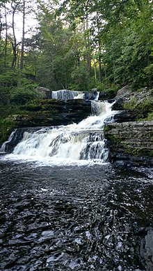
boardwalk is roughly 0.5 miles (0.80 km) long and takes you to the base of the falls, but also passes by
Silverthread Falls. You can continue on up a series of stairs to the waterfall and see the entire 130-foot (40 m) plunge from the birds eye view. The best time to see this waterfall is about 24 hours after a hard rain, when it will be flowing fast and steady. This is probably the best known waterfall of Delaware Water Gap National Recreation Park.
229:
past. The trail itself features a densely covered hemlock ravine that hosts various delicate plants and species of wildlife. The root systems at the base of many of the hemlocks have been damaged due to high foot traffic in the area. This, in addition to storm damage and a lack of funding, has led the
National Park Service and Department of the Interior to close the Lower Van Campens Glen trail indefinitely, due to public hazard, as of Spring 2019.
95:
144:
152:
228:
is the terminus of the Lower Van
Campens Glen trail hike near Walpack, NJ. The top of the falls features a deep, large pool that cascades down a slanted rock face. The areas surrounding the upper pool require extreme caution as this area has been responsible for numerous accidents and deaths in years
105:
is the second highest waterfall in the state of
Pennsylvania with a plunge of 130 feet (40 m). It is located at the northern end of the DWG park. There is a beautiful (composite) boardwalk that leads you to the base of the waterfall where you can see the 80-foot (24 m) cascading drop. This
125:
is also located in upper
Pennsylvania, less than 0.5 miles (0.80 km) from Dingmans Falls. This waterfall exhibits a steep drop of about 80 feet (24 m) via a narrow channel constructed of prominent rock-joints faces, however the volume of flow is much less than Dingmans Falls. Visitors can
134:
Factory Falls is located on the George W. Childs Park Trail in
Pennsylvania, it follows Dingmans Creek so you are very close to Dingmans falls. The Brooks Family ran a woolen mill from 1823 to 1832 next to this fall, the remains of the mill can be seen next to the fall. You will take a single path
162:
is the second waterfall you will see on the George W. Childs Park Trail in
Pennsylvania right after Factory Falls. This fall is 56 feet (17 m) tall and is the largest in George W. Childs Park. This waterfall has a unique feature of falling in a semi-circular basin of rock and then flowing
81:
Buttermilk Falls is one of the tallest waterfalls of New Jersey. A dirt road (closed to vehicles in the winter) goes past its base. A series of steps lead to observation platforms further up the waterfall, which is nearly 100 feet (30 m) high. A trail continues eastward from the topmost
196:
is about 100 feet (30 m). While the drop from the first falls to the bottom of the lower gorge is about 300 feet (91 m). This set of falls is on privately owned land, and has an admission charge. They are advertised with the slogan "The
Niagara of Pennsylvania".
135:
through the woods that runs on both sides of the creek that is roughly 1.5 miles (2.4 km) in length. This waterfall is the first one in a set of three that is on this traill. Factory Falls drops twice and makes a 90 degree turn with the creek.
191:
There are eight waterfalls and more than 2 miles (3.2 km) of trail on these 300 acres (120 ha), located in
Pennsylvania near the top of Delaware Water Gap National Recreational park. The drop of the main fall of
868:
610:
86:, about 1,100 feet (340 m) higher in elevation than the base of the falls, in about 1.4 miles (2.3 km). The waterfall is near the north end of the Delaware Water Gap National Recreation Area in New Jersey.
281:
603:
913:
1012:
596:
1032:
564:
619:
40:
439:
408:
936:
217:. It is the tallest waterfall in Pennsylvania. The three tiers of Raymondskill Falls have a combined height of approximately 150 feet (46 m).
205:
848:
126:
view both
Silverthread and Ding Dong Falls via the same (composite) boardwalk & trail emanating from the Dingmans Falls Visitor Center.
1027:
1022:
658:
356:
941:
725:
648:
991:
923:
863:
821:
668:
853:
779:
332:
698:
774:
715:
183:
908:
653:
214:
858:
786:
45:
17:
415:
163:
downstream. The base of this waterfall is not accessible unless the fence is jumped, this is not prohibited.
1017:
791:
225:
73:
578:
843:
740:
893:
873:
720:
453:
49:
579:"Winter Storm Damage Update - Delaware Water Gap National Recreation Area (U.S. National Park Service)"
114:
542:
730:
260:
745:
703:
384:
958:
816:
693:
633:
122:
497:
213:
Raymondskill Falls are a series of three cascading waterfalls located on Raymondskill Creek in
883:
643:
588:
433:
83:
306:"Visitor Centers - Delaware Water Gap National Recreation Area (U.S. National Park Service)"
305:
29:
946:
764:
472:
172:
94:
565:"New Jersey Man Possible Drowning Victim at Delaware Water Gap National Recreation Area"
931:
898:
888:
833:
752:
638:
193:
102:
1006:
878:
838:
735:
708:
951:
808:
796:
159:
57:
246:
143:
247:"Maps - Delaware Water Gap National Recreation Area (U.S. National Park Service)"
826:
757:
151:
769:
685:
53:
385:"Walk along the waterfall trails within Delaware Water Gap Recreation Center"
903:
473:"Pennsylvania Waterfalls: The Falls of George W. Childs Park - UncoveringPA"
663:
521:
204:
182:
150:
142:
113:
93:
72:
28:
592:
171:
The third last fall of the trail of George W. Childs Park is
984:
922:
807:
684:
626:
357:"Dingmans Falls at Dingmans Falls Visitors Center"
18:Buttermilk Falls (Walpack Township, New Jersey)
333:"Dingmans Falls | Scenic, Wild Delaware River"
604:
8:
1013:Delaware Water Gap National Recreation Area
620:Delaware Water Gap National Recreation Area
41:Delaware Water Gap National Recreation Area
919:
681:
611:
597:
589:
1033:Lists of waterfalls in the United States
238:
209:Middle and lower Ranymondskill cascades
438:: CS1 maint: archived copy as title (
431:
937:Dingman's Ferry Dutch Reformed Church
467:
465:
463:
7:
378:
376:
327:
325:
118:Silver Thread Falls Boardwalk View
25:
975:
942:George W. Childs Recreation Site
726:Old Mine Road Historic District
337:delawareriver.natgeotourism.com
649:Delaware Water Gap Toll Bridge
1:
992:Tocks Island Dam controversy
864:Cold Spring Farm Springhouse
669:Minisink Archaeological Site
659:Milford–Montague Toll Bridge
854:Capt. Jacob Shoemaker House
1049:
1028:Waterfalls of Pennsylvania
869:Delaware Water Gap station
543:"Raymondskill Creek Trail"
973:
909:Schoonover Mountain House
215:Pike County, Pennsylvania
33:Map of Delaware Water Gap
1023:Waterfalls of New Jersey
787:Worthington State Forest
454:"NPS - Page In-Progress"
261:"Buttermilk Falls Trail"
98:Dingmans Falls Base View
46:national recreation area
792:Mount Tammany Fire Road
545:. National Park Service
502:www.poconomountains.com
361:www.poconomountains.com
82:platform, reaching the
741:Pahaquarry Copper Mine
699:Foster–Armstrong House
654:Dingman's Ferry Bridge
226:Van Campens Glen Falls
221:Van Campens Glen Falls
210:
188:
156:
148:
119:
99:
78:
34:
894:Marie Zimmermann Farm
208:
186:
154:
146:
117:
97:
76:
50:National Park Service
32:
914:Zion Lutheran Church
731:Cornelius Gunn House
704:Kittatinny Mountain
959:Silverthread Falls
817:Big Bushkill Creek
634:Delaware Water Gap
627:Points of interest
211:
201:Raymondskill Falls
189:
157:
149:
147:Factory Falls View
123:Silverthread Falls
120:
110:Silverthread Falls
100:
79:
39:waterfalls in the
35:
1000:
999:
971:
970:
967:
966:
884:John Michael Farm
644:Appalachian Trail
155:Fulmer Falls View
84:Appalachian Trail
16:(Redirected from
1040:
979:
978:
920:
746:Van Campen's Inn
682:
613:
606:
599:
590:
583:
582:
575:
569:
568:
561:
555:
554:
552:
550:
539:
533:
532:
530:
528:
522:"Bushkill Falls"
518:
512:
511:
509:
508:
498:"Bushkill Falls"
494:
488:
487:
485:
484:
469:
458:
457:
450:
444:
443:
437:
429:
427:
426:
420:
414:. Archived from
413:
405:
399:
398:
396:
395:
389:poconorecord.com
380:
371:
370:
368:
367:
353:
347:
346:
344:
343:
329:
320:
319:
317:
316:
302:
296:
295:
293:
292:
278:
272:
271:
269:
267:
257:
251:
250:
243:
77:Buttermilk Falls
69:Buttermilk Falls
21:
1048:
1047:
1043:
1042:
1041:
1039:
1038:
1037:
1003:
1002:
1001:
996:
980:
976:
963:
947:Deer Leap Falls
918:
803:
780:Wallpack Center
765:Wallpack Valley
680:
622:
617:
587:
586:
577:
576:
572:
563:
562:
558:
548:
546:
541:
540:
536:
526:
524:
520:
519:
515:
506:
504:
496:
495:
491:
482:
480:
471:
470:
461:
452:
451:
447:
430:
424:
422:
418:
411:
409:"Archived copy"
407:
406:
402:
393:
391:
383:JOHNSON, KENT.
382:
381:
374:
365:
363:
355:
354:
350:
341:
339:
331:
330:
323:
314:
312:
304:
303:
299:
290:
288:
280:
279:
275:
265:
263:
259:
258:
254:
245:
244:
240:
235:
223:
203:
181:
173:Deer Leap Falls
169:
167:Deer Leap Falls
141:
132:
112:
92:
71:
66:
48:managed by the
37:There are many
23:
22:
15:
12:
11:
5:
1046:
1044:
1036:
1035:
1030:
1025:
1020:
1018:Delaware River
1015:
1005:
1004:
998:
997:
995:
994:
988:
986:
982:
981:
974:
972:
969:
968:
965:
964:
962:
961:
956:
955:
954:
949:
939:
934:
932:Dingmans Falls
928:
926:
924:Dingmans Ferry
917:
916:
911:
906:
901:
899:Metz Ice Plant
896:
891:
889:John Turn Farm
886:
881:
876:
871:
866:
861:
856:
851:
849:Callahan House
846:
841:
836:
834:Brodhead Creek
831:
830:
829:
819:
813:
811:
805:
804:
802:
801:
800:
799:
794:
784:
783:
782:
777:
775:Flatbrookville
772:
762:
761:
760:
753:Wallpack Ridge
750:
749:
748:
743:
738:
733:
723:
718:
713:
712:
711:
701:
696:
690:
688:
679:
678:
673:
672:
671:
661:
656:
651:
646:
641:
639:Delaware River
636:
630:
628:
624:
623:
618:
616:
615:
608:
601:
593:
585:
584:
570:
556:
534:
513:
489:
459:
445:
400:
372:
348:
321:
297:
273:
252:
237:
236:
234:
231:
222:
219:
202:
199:
194:Bushkill Falls
187:Bushkill Falls
180:
179:Bushkill Falls
177:
168:
165:
140:
137:
131:
128:
111:
108:
103:Dingmans Falls
91:
90:Dingmans Falls
88:
70:
67:
65:
62:
24:
14:
13:
10:
9:
6:
4:
3:
2:
1045:
1034:
1031:
1029:
1026:
1024:
1021:
1019:
1016:
1014:
1011:
1010:
1008:
993:
990:
989:
987:
983:
960:
957:
953:
950:
948:
945:
944:
943:
940:
938:
935:
933:
930:
929:
927:
925:
921:
915:
912:
910:
907:
905:
902:
900:
897:
895:
892:
890:
887:
885:
882:
880:
879:Fort Hyndshaw
877:
875:
872:
870:
867:
865:
862:
860:
857:
855:
852:
850:
847:
845:
842:
840:
839:Brodhead Farm
837:
835:
832:
828:
825:
824:
823:
822:Blue Mountain
820:
818:
815:
814:
812:
810:
806:
798:
795:
793:
790:
789:
788:
785:
781:
778:
776:
773:
771:
768:
767:
766:
763:
759:
756:
755:
754:
751:
747:
744:
742:
739:
737:
736:Old Mine Road
734:
732:
729:
728:
727:
724:
722:
719:
717:
716:Military Road
714:
710:
709:Mount Tammany
707:
706:
705:
702:
700:
697:
695:
692:
691:
689:
687:
683:
677:
674:
670:
667:
666:
665:
662:
660:
657:
655:
652:
650:
647:
645:
642:
640:
637:
635:
632:
631:
629:
625:
621:
614:
609:
607:
602:
600:
595:
594:
591:
580:
574:
571:
566:
560:
557:
544:
538:
535:
523:
517:
514:
503:
499:
493:
490:
478:
474:
468:
466:
464:
460:
455:
449:
446:
441:
435:
421:on 2017-09-23
417:
410:
404:
401:
390:
386:
379:
377:
373:
362:
358:
352:
349:
338:
334:
328:
326:
322:
311:
307:
301:
298:
287:
283:
282:"Google Maps"
277:
274:
266:September 22,
262:
256:
253:
248:
242:
239:
232:
230:
227:
220:
218:
216:
207:
200:
198:
195:
185:
178:
176:
174:
166:
164:
161:
153:
145:
138:
136:
130:Factory Falls
129:
127:
124:
116:
109:
107:
104:
96:
89:
87:
85:
75:
68:
63:
61:
59:
55:
51:
47:
43:
42:
31:
27:
19:
952:Fulmer Falls
809:Pennsylvania
797:Sunfish Pond
675:
573:
559:
547:. Retrieved
537:
525:. Retrieved
516:
505:. Retrieved
501:
492:
481:. Retrieved
479:. 2015-12-14
477:UncoveringPA
476:
448:
423:. Retrieved
416:the original
403:
392:. Retrieved
388:
364:. Retrieved
360:
351:
340:. Retrieved
336:
313:. Retrieved
309:
300:
289:. Retrieved
285:
276:
264:. Retrieved
255:
241:
224:
212:
190:
170:
160:Fulmer Falls
158:
139:Fulmer Falls
133:
121:
101:
80:
58:Pennsylvania
38:
36:
26:
827:Mount Minsi
758:Brau Kettle
527:29 December
310:www.nps.gov
286:Google Maps
1007:Categories
859:Conashaugh
770:Flat Brook
686:New Jersey
676:Waterfalls
549:15 October
507:2017-09-23
483:2017-09-23
425:2017-09-23
394:2017-09-23
366:2017-09-22
342:2017-09-23
315:2017-09-22
291:2017-09-22
233:References
54:New Jersey
904:Nyce Farm
721:Millbrook
844:Bushkill
664:Minisink
434:cite web
985:History
874:Eshback
694:Bevans
419:(PDF)
412:(PDF)
551:2017
529:2020
440:link
268:2017
64:List
56:and
44:, a
52:in
1009::
500:.
475:.
462:^
436:}}
432:{{
387:.
375:^
359:.
335:.
324:^
308:.
284:.
60:.
612:e
605:t
598:v
581:.
567:.
553:.
531:.
510:.
486:.
456:.
442:)
428:.
397:.
369:.
345:.
318:.
294:.
270:.
249:.
20:)
Text is available under the Creative Commons Attribution-ShareAlike License. Additional terms may apply.