85:
57:
40:
341:
92:
64:
364:. Morris Brook starts just east of Shacktown Mountain and flows south into Allen Pond. It exits Allen Pond and continues flowing south through Dimock Hollow before flowing into Morris Pond. It exits Morris Pond and flows southeast before converging with Butternut Creek southwest of
84:
56:
332:
called the creek the
Tienuderrah. General Jacob Morris visited the area in 1787, and described Butternut Creek as "the handsomest navigable creek I ever lay my eyes upon."
376:. Halbert Brook flows into the creek southwest of Gilbertsville. Dry Brook flows into the creek southwest of Gilbertsville. Dry Brook was formally known as "Copes Brook".
443:
960:
171:
989:
883:
849:
755:
721:
687:
653:
619:
585:
551:
517:
979:
994:
802:
984:
874:
840:
746:
712:
678:
644:
610:
576:
542:
508:
953:
879:
845:
751:
717:
683:
649:
615:
581:
547:
513:
776:
903:
792:
778:
Drainage Areas of New York
Streams, by River Basins: A Stream Gazetteer : Part 1, Data Compiled as of October 1980
946:
365:
360:. Dunderberg Creek flows into the creek east of Gilbertsville. Calhoun Creek flows into the creek southeast of
869:
835:
741:
707:
673:
639:
605:
571:
537:
503:
458:
373:
369:
357:
353:
819:
298:
157:
39:
349:
340:
437:
392:
276:
Calhoun Creek, Morris Brook, Thorp Brook, Coye Brook, Dunderberg Creek, Halbert Brook, Dry Brook
419:
17:
798:
477:
238:
930:
361:
290:
128:
489:
306:
302:
314:
294:
246:
242:
145:
973:
329:
322:
140:
186:
173:
821:
Manual for the
Fisherman: A Practical Guide for Fresh and Salt Water Fishing
318:
310:
339:
286:
91:
63:
99:
Butternut Creek (Unadilla River tributary) (the United States)
393:"USGS 0150238005 BUTTERNUT CREEK AT MOUTH AT MOUNT UPTON NY"
457:
Morris, Jacob; Young, Hollis (ed.); Young, Debbie (ed.).
934:
44:
794:
Eastern New York All-Outdoors Atlas & Field Guide
352:. Shaw Brook flows into the creek south-southwest of
301:. The creek has many fish for fishing dominated by
270:
260:
252:
233:
228:
220:
212:
202:
163:
151:
139:
134:
124:
116:
111:
32:
929:This article related to a river in New York is a
368:. Thorp Brook flows into the creek northeast of
372:. Coye Brook flows into the creek northeast of
348:Stony Creek flows into the creek northwest of
954:
459:"BUTTERNUTS CREEK, 12 MILE FROM THE UNADILLA"
8:
356:. Cahoon Creek flows into the creek east of
344:Stony Clove Creek downstream of Parker Road.
961:
947:
442:: CS1 maint: location missing publisher (
884:United States Department of the Interior
850:United States Department of the Interior
756:United States Department of the Interior
722:United States Department of the Interior
688:United States Department of the Interior
654:United States Department of the Interior
620:United States Department of the Interior
586:United States Department of the Interior
552:United States Department of the Interior
518:United States Department of the Interior
71:Location of the mouth of Butternut Creek
384:
797:. Sportsman's Connection. 2016-08-27.
485:
475:
435:
29:
266:Stony Creek, Cahoon Creek, Shaw Brook
7:
926:
924:
74:Show map of New York Adirondack Park
875:Geographic Names Information System
841:Geographic Names Information System
747:Geographic Names Information System
713:Geographic Names Information System
679:Geographic Names Information System
645:Geographic Names Information System
611:Geographic Names Information System
577:Geographic Names Information System
543:Geographic Names Information System
509:Geographic Names Information System
237:Butternut Creek → Unadilla River →
933:. You can help Knowledge (XXG) by
25:
990:Rivers of Otsego County, New York
399:. United States Geological Survey
224:130 sq mi (340 km)
90:
83:
62:
55:
38:
27:River in New York, United States
880:United States Geological Survey
846:United States Geological Survey
752:United States Geological Survey
718:United States Geological Survey
684:United States Geological Survey
650:United States Geological Survey
616:United States Geological Survey
582:United States Geological Survey
548:United States Geological Survey
514:United States Geological Survey
424:. Detroit, Michigan. p. 20
285:is a 37-mile-long (60 km)
18:Butternut Creek (Otsego County)
165: • coordinates
1:
980:Geography of New York (state)
135:Physical characteristics
102:Show map of the United States
995:New York (state) river stubs
204: • elevation
418:Eddy, Hilah Violet (1926).
153: • location
1011:
985:Rivers of New York (state)
923:
818:Smith, Stanley E. (1950).
208:1,000 ft (300 m)
824:. News Syndicate Company.
781:. U.S. Geological Survey.
775:Wagner, Lloyd A. (1982).
49:
37:
293:. It converges with the
272: • right
262: • left
216:37 mi (60 km)
345:
343:
187:42.41528°N 75.37500°W
158:Mount Upton, New York
908:historicmapworks.com
297:just downstream of
229:Basin features
192:42.41528; -75.37500
183: /
606:"Dunderberg Creek"
488:has generic name (
346:
942:
941:
904:"Butternuts Town"
804:978-1-885010-78-0
280:
279:
239:Susquehanna River
16:(Redirected from
1002:
963:
956:
949:
925:
919:
918:
916:
914:
900:
894:
893:
891:
890:
866:
860:
859:
857:
856:
832:
826:
825:
815:
809:
808:
789:
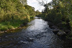
783:
782:
772:
766:
765:
763:
762:
738:
732:
731:
729:
728:
704:
698:
697:
695:
694:
670:
664:
663:
661:
660:
636:
630:
629:
627:
626:
602:
596:
595:
593:
592:
568:
562:
561:
559:
558:
534:
528:
527:
525:
524:
500:
494:
493:
487:
483:
481:
473:
471:
469:
454:
448:
447:
441:
433:
431:
429:
415:
409:
408:
406:
404:
389:
289:in the state of
273:
263:
198:
197:
195:
194:
193:
188:
184:
181:
180:
179:
176:
103:
94:
93:
87:
75:
66:
65:
59:
42:
30:
21:
1010:
1009:
1005:
1004:
1003:
1001:
1000:
999:
970:
969:
968:
967:
922:
912:
910:
902:
901:
897:
888:
886:
868:
867:
863:
854:
852:
836:"Halbert Brook"
834:
833:
829:
817:
816:
812:
805:
791:
790:
786:
774:
773:
769:
760:
758:
740:
739:
735:
726:
724:
706:
705:
701:
692:
690:
672:
671:
667:
658:
656:
640:"Calhoun Creek"
638:
637:
633:
624:
622:
604:
603:
599:
590:
588:
570:
569:
565:
556:
554:
536:
535:
531:
522:
520:
502:
501:
497:
484:
474:
467:
465:
456:
455:
451:
434:
427:
425:
417:
416:
412:
402:
400:
391:
390:
386:
382:
338:
307:smallmouth bass
303:largemouth bass
283:Butternut Creek
271:
261:
205:
191:
189:
185:
182:
177:
174:
172:
170:
169:
166:
154:
107:
106:
105:
104:
101:
100:
97:
96:
95:
78:
77:
76:
73:
72:
69:
68:
67:
45:
33:Butternut Creek
28:
23:
22:
15:
12:
11:
5:
1008:
1006:
998:
997:
992:
987:
982:
972:
971:
966:
965:
958:
951:
943:
940:
939:
921:
920:
895:
861:
827:
810:
803:
784:
767:
733:
699:
674:"Morris Brook"
665:
631:
597:
572:"Cahoon Creek"
563:
529:
495:
449:
410:
383:
381:
378:
337:
334:
315:chain pickerel
295:Unadilla River
278:
277:
274:
268:
267:
264:
258:
257:
254:
250:
249:
247:Atlantic Ocean
243:Chesapeake Bay
235:
231:
230:
226:
225:
222:
218:
217:
214:
210:
209:
206:
203:
200:
199:
167:
164:
161:
160:
155:
152:
149:
148:
146:Unadilla River
143:
137:
136:
132:
131:
126:
122:
121:
118:
114:
113:
109:
108:
98:
89:
88:
82:
81:
80:
79:
70:
61:
60:
54:
53:
52:
51:
50:
47:
46:
43:
35:
34:
26:
24:
14:
13:
10:
9:
6:
4:
3:
2:
1007:
996:
993:
991:
988:
986:
983:
981:
978:
977:
975:
964:
959:
957:
952:
950:
945:
944:
938:
936:
932:
927:
909:
905:
899:
896:
885:
881:
877:
876:
871:
865:
862:
851:
847:
843:
842:
837:
831:
828:
823:
822:
814:
811:
806:
800:
796:
795:
788:
785:
780:
779:
771:
768:
757:
753:
749:
748:
743:
737:
734:
723:
719:
715:
714:
709:
708:"Thorp Brook"
703:
700:
689:
685:
681:
680:
675:
669:
666:
655:
651:
647:
646:
641:
635:
632:
621:
617:
613:
612:
607:
601:
598:
587:
583:
579:
578:
573:
567:
564:
553:
549:
545:
544:
539:
533:
530:
519:
515:
511:
510:
505:
504:"Stony Creek"
499:
496:
491:
486:|first2=
479:
464:
460:
453:
450:
445:
439:
423:
422:
421:The Lull Book
414:
411:
398:
394:
388:
385:
379:
377:
375:
374:Gilbertsville
371:
370:Gilbertsville
367:
363:
359:
358:Gilbertsville
355:
354:Gilbertsville
351:
342:
335:
333:
331:
326:
324:
320:
316:
312:
308:
304:
300:
296:
292:
288:
284:
275:
269:
265:
259:
255:
251:
248:
244:
240:
236:
232:
227:
223:
219:
215:
211:
207:
201:
196:
168:
162:
159:
156:
150:
147:
144:
142:
138:
133:
130:
127:
123:
120:United States
119:
115:
110:
86:
58:
48:
41:
36:
31:
19:
935:expanding it
928:
913:16 September
911:. Retrieved
907:
898:
887:. Retrieved
873:
864:
853:. Retrieved
839:
830:
820:
813:
793:
787:
777:
770:
759:. Retrieved
745:
742:"Coye Brook"
736:
725:. Retrieved
711:
702:
691:. Retrieved
677:
668:
657:. Retrieved
643:
634:
623:. Retrieved
609:
600:
589:. Retrieved
575:
566:
555:. Retrieved
541:
538:"Shaw Brook"
532:
521:. Retrieved
507:
498:
466:. Retrieved
463:usgennet.org
462:
452:
426:. Retrieved
420:
413:
403:September 3,
401:. Retrieved
396:
387:
347:
327:
323:yellow perch
282:
281:
870:"Dry Brook"
336:Tributaries
299:Mount Upton
253:Tributaries
234:Progression
190: /
974:Categories
889:2018-09-09
855:2018-09-09
761:2018-09-09
727:2018-09-09
693:2018-09-09
659:2017-06-03
625:2018-09-09
591:2017-06-03
557:2018-09-09
523:2017-06-03
380:References
350:New Lisbon
221:Basin size
178:75°22′30″W
175:42°24′55″N
438:cite book
319:rock bass
478:cite web
397:usgs.gov
311:wall-eye
291:New York
129:New York
112:Location
468:Oct 20,
428:Oct 20,
117:Country
801:
366:Morris
362:Morris
330:Mohawk
321:, and
256:
213:Length
287:river
141:Mouth
125:State
931:stub
915:2018
799:ISBN
490:help
470:2020
444:link
430:2020
405:2021
328:The
976::
906:.
882:,
878:.
872:.
848:,
844:.
838:.
754:,
750:.
744:.
720:,
716:.
710:.
686:,
682:.
676:.
652:,
648:.
642:.
618:,
614:.
608:.
584:,
580:.
574:.
550:,
546:.
540:.
516:,
512:.
506:.
482::
480:}}
476:{{
461:.
440:}}
436:{{
395:.
325:.
317:,
313:,
309:,
305:,
245:→
241:→
962:e
955:t
948:v
937:.
917:.
892:.
858:.
807:.
764:.
730:.
696:.
662:.
628:.
594:.
560:.
526:.
492:)
472:.
446:)
432:.
407:.
20:)
Text is available under the Creative Commons Attribution-ShareAlike License. Additional terms may apply.