56:
639:
63:
40:
619:
391:
and is fed primarily by rain and snow. Many stretches freeze to the bottom in the winter. The tributaries of the
Byoryolyokh are mostly short. Some of the main ones are the 61 kilometres (38 mi) long
522:/ Scientific ed. G. A. Menovschikov ; FEB AN USSR . North-East complex. Research institute for Archeology, History and Ethnography. - Magadan: Magad. Prince Publishing House , 1989 . P. 85 . -
452:
360:
and for almost four decades it was thought that it was one of the rivers whose confluence formed the Kolyma. However, after a more thorough survey of the region carried out by
55:
676:
197:
623:
695:
700:
527:
132:
669:
384:
it heads roughly southwestwards and finally it meets the Ayan-Yuryakh shortly upstream from its confluence with the Kulu.
705:
662:
429:
388:
496:
409:
361:
397:
110:
413:
417:
401:
322:
405:
393:
364:
in 1929 it was established that the two rivers forming the Kolyma are the Ayan-Yuryakh and the
523:
297:
646:
542:/ V. F. Bely, G. L. Maltsev & K. A. Novikova - reviewers - Magadan Book Publishing House
310:
638:
377:
337:
318:
293:
114:
98:
71:
689:
602:
365:
357:
330:
326:
289:
183:
582:
583:"Топографска карта P-55 56; M 1:1 000 000 - Topographic USSR Chart (in Russian)"
178:
20:
487:
380:
and heads southwards below the western slopes of the range. After passing by
212:
199:
147:
134:
556:
39:
618:
543:
381:
118:
75:
345:
416:
from the left, as well as the 48 kilometres (30 mi) long
376:
The
Byoryolyokh has its sources at the northern end of the
650:
356:
285:
280:
266:
258:
246:
238:
228:
189:
177:
163:
124:
104:
94:
85:
28:
520:Toponymic Dictionary of the North-East of the USSR
62:
344:(Бөрөлөөх), referring to a place where there are
645:This article related to a river in Russia is a
482:
480:
478:
250:9,810 square kilometres (3,790 sq mi)
670:
447:
445:
8:
677:
663:
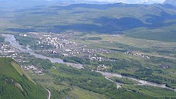
44:The Byoryolokh flowing across Susuman town
412:and the 69 kilometres (43 mi) long
441:
408:, the 106 kilometres (66 mi) long
272:315 m/s (11,100 cu ft/s)
400:, the 44 kilometres (27 mi) long
396:, the 45 kilometres (28 mi) long
336:The name of the river is based on the
25:
7:
635:
633:
649:. You can help Knowledge (XXG) by
14:
561:Больша́я сове́тская энциклопе́дия
538:B.G. Shcherbinin, V.V. Leont'ev.
637:
617:
325:. It is a left tributary of the
61:
54:
38:
518:Leontyev V.V. , Novikova K.A.
490:[Ayan-Yuryakh River].
191: • coordinates
126: • coordinates
19:For the river in Yakutia, see
1:
492:Государственный Водный Реестр
86:Physical characteristics
242:239 kilometres (149 mi)
230: • elevation
169:1,540 metres (5,050 ft)
165: • elevation
387:The river flows across the
106: • location
722:
632:
624:Byoryolyokh (Ayan-Yuryakh)
540:Where geologists have gone
268: • average
234:545 metres (1,788 ft)
18:
696:Tributaries of the Kolyma
314:
276:
254:
173:
90:
49:
37:
701:Rivers of Magadan Oblast
455:[Ayan-Yuryakh].
430:List of rivers of Russia
389:Upper Kolyma Highlands
213:62.41528°N 147.53694°E
148:63.93028°N 146.99639°E
626:at Wikimedia Commons
546:, 1980. - pp. 25-27.
497:State Water Register
281:Basin features
218:62.41528; 147.53694
209: /
153:63.93028; 146.99639
144: /
111:Susumansky District
706:Russia river stubs
500:] (in Russian)
463:] (in Russian)
323:Russian Federation
70:Mouth location in
658:
657:
622:Media related to
303:
302:
298:East Siberian Sea
713:
679:
672:
665:
641:
634:
621:
605:
600:
594:
593:
591:
589:
579:
573:
572:
570:
568:
553:
547:
536:
530:
516:
510:
509:
507:
505:
484:
473:
472:
470:
468:
449:
420:from the right.
317:) is a river in
316:
269:
224:
223:
221:
220:
219:
214:
210:
207:
206:
205:
202:
166:
159:
158:
156:
155:
154:
149:
145:
142:
141:
140:
137:
127:
107:
65:
64:
58:
42:
26:
721:
720:
716:
715:
714:
712:
711:
710:
686:
685:
684:
683:
630:
614:
609:
608:
601:
597:
587:
585:
581:
580:
576:
566:
564:
555:
554:
550:
537:
533:
517:
513:
503:
501:
486:
485:
476:
466:
464:
451:
450:
443:
438:
426:
374:
362:Sergei Obruchev
354:
267:
231:
217:
215:
211:
208:
203:
200:
198:
196:
195:
192:
164:
152:
150:
146:
143:
138:
135:
133:
131:
130:
125:
105:
81:
80:
79:
78:
68:
67:
66:
45:
33:
30:
24:
17:
12:
11:
5:
719:
717:
709:
708:
703:
698:
688:
687:
682:
681:
674:
667:
659:
656:
655:
642:
628:
627:
613:
612:External links
610:
607:
606:
595:
574:
548:
531:
511:
488:"Река Берелёх"
474:
440:
439:
437:
434:
433:
432:
425:
422:
378:Okhandya Range
373:
370:
353:
350:
319:Magadan Oblast
301:
300:
287:
283:
282:
278:
277:
274:
273:
270:
264:
263:
260:
256:
255:
252:
251:
248:
244:
243:
240:
236:
235:
232:
229:
226:
225:
193:
190:
187:
186:
181:
175:
174:
171:
170:
167:
161:
160:
128:
122:
121:
115:Magadan Oblast
108:
102:
101:
99:Okhandya Range
96:
92:
91:
88:
87:
83:
82:
72:Magadan Oblast
69:
60:
59:
53:
52:
51:
50:
47:
46:
43:
35:
34:
31:
16:Siberian river
15:
13:
10:
9:
6:
4:
3:
2:
718:
707:
704:
702:
699:
697:
694:
693:
691:
680:
675:
673:
668:
666:
661:
660:
654:
652:
648:
643:
640:
636:
631:
625:
620:
616:
615:
611:
604:
599:
596:
584:
578:
575:
562:
558:
552:
549:
545:
541:
535:
532:
529:
528:5-7581-0044-7
525:
521:
515:
512:
499:
498:
493:
489:
483:
481:
479:
475:
462:
458:
454:
448:
446:
442:
435:
431:
428:
427:
423:
421:
419:
415:
411:
407:
404:flowing from
403:
399:
395:
390:
385:
383:
379:
371:
369:
367:
363:
359:
351:
349:
347:
343:
339:
334:
332:
328:
324:
320:
312:
308:
299:
295:
291:
288:
284:
279:
275:
271:
265:
261:
257:
253:
249:
245:
241:
237:
233:
227:
222:
194:
188:
185:
182:
180:
176:
172:
168:
162:
157:
129:
123:
120:
116:
112:
109:
103:
100:
97:
93:
89:
84:
77:
73:
57:
48:
41:
36:
27:
22:
651:expanding it
644:
629:
603:Google Earth
598:
586:. Retrieved
577:
565:. Retrieved
563:(in Russian)
560:
551:
539:
534:
519:
514:
502:. Retrieved
495:
491:
465:. Retrieved
461:Water Russia
460:
456:
414:Sylgybystakh
386:
375:
358:Ivan Chersky
355:
341:
335:
331:Kolyma river
327:Ayan-Yuryakh
306:
304:
290:Ayan-Yuryakh
184:Ayan-Yuryakh
457:Вода Россия
418:Chay-Yuryue
402:Malyk-Siena
342:"Börölöökh"
307:Byoryolyokh
286:Progression
216: /
204:147°32′13″E
151: /
139:146°59′47″E
29:Byoryolyokh
21:Byoryolyokh
690:Categories
557:"Аян-Юрях"
453:"Аян-Юрях"
436:References
406:Lake Malyk
247:Basin size
201:62°24′55″N
136:63°55′49″N
588:3 January
394:Burgandya
259:Discharge
424:See also
567:10 July
544:Magadan
504:10 July
467:10 July
410:Susuman
382:Susuman
352:History
333:basin.
329:of the
315:Бёрёлёх
311:Russian
32:Бёрёлёх
526:
398:Taboga
372:Course
346:wolves
294:Kolyma
262:
239:Length
119:Russia
95:Source
76:Russia
494:[
459:[
340:word
338:Yakut
179:Mouth
647:stub
590:2022
569:2021
524:ISBN
506:2021
469:2021
366:Kulu
305:The
692::
559:.
477:^
444:^
368:.
348:.
321:,
313::
296:→
292:→
117:,
113:,
74:,
678:e
671:t
664:v
653:.
592:.
571:.
508:.
471:.
309:(
23:.
Text is available under the Creative Commons Attribution-ShareAlike License. Additional terms may apply.