164:
134:
171:
141:
36:
342:
384:
with an elevation of 843 meters (2,766 ft) and a base diameter of about 8 kilometers (5.0 mi) located in the center of
Babuyan Island (also referred to as Babuyan Claro Island). It has four morphologically-fresh volcanic edifices: Mt. Cayonan in the south, Mt. Naydi and Mt. Dionisio in
388:
The
Askedna Hot Spring is located at the southern basal slope of Babuyan Claro. It has a temperature range of 44.6 to 50.2 °C (112.3 to 122.4 °F). The water is slightly acidic and the silica content is relatively high since the spring flows directly from lava flow deposits. The spring
444:
In
February 2004, there were reports of grayish steam clouds hovering above the summit but volcanologists from PHIVOLCS said the seismic swarm was of tectonic origin and the steaming activity was only wispy to weak.
627:
464:
601:
507:
422:
502:
89:
632:
469:
163:
986:
966:
622:
610:
459:
335:
74:
594:
133:
976:
981:
587:
947:
454:
433:
In July 1993, there were reports of earthquakes and alleged drying up of vegetation at the upper slopes and summit area of the volcano but
232:
401:
Babuyan Claro has two confirmed historical eruptions: in 1831 and 1860. The eruption on 1913 is listed as uncertain by the
991:
971:
385:
the southeast. Babuyan Claro has two very well-preserved craters 300 and 400 meters (980 and 1,310 ft) in diameter.
513:
216:
82:
570:
Base diameter measured using Google Earth as the data at PHIVOLCS is incorrect at 0.820 meters (2 ft 8.3 in).
285:
369:
204:
228:
727:
545:
402:
775:
550:
406:
263:
58:
701:
681:
925:
249:
68:
930:
770:
744:
890:
870:
800:
785:
780:
749:
358:
237:
910:
895:
840:
686:
418:
390:
319:
900:
880:
711:
666:
366:
315:
308:
209:
960:
855:
825:
790:
716:
676:
671:
661:
434:
410:
381:
346:
268:
865:
845:
835:
805:
721:
323:
275:
35:
935:
920:
915:
795:
696:
691:
414:
331:
197:
579:
540:
905:
875:
850:
341:
104:
91:
830:
255:
438:
354:
441:
in origin and there was no significant change in the volcanic activity.
885:
754:
362:
311:
221:
48:
860:
706:
340:
327:
583:
353:
The volcano is politically located in the similarly-named
338:
of the country with the last confirmed eruption in 1860.
465:
List of potentially active volcanoes in the
Philippines
413:. Eruptions on Babuyan Claro is determined as probably
409:
while the 1917 eruption is confirmed as an eruption of
818:
763:
737:
649:
642:
284:
274:
262:
248:
243:
227:
215:
203:
193:
120:
81:
67:
57:
47:
42:
23:
508:Philippine Institute of Volcanology and Seismology
423:Philippine Institute of Volcanology and Seismology
595:
470:List of inactive volcanoes in the Philippines
8:
460:List of active volcanoes in the Philippines
280:Babuyan (Bashi) Segment of Luzon-Taiwan Arc
646:
602:
588:
580:
497:
495:
493:
491:
489:
487:
20:
389:water can be classified as near-neutral
483:
535:
533:
531:
170:
140:
7:
948:List of mountains in the Philippines
628:List of potentially active volcanoes
455:List of volcanoes in the Philippines
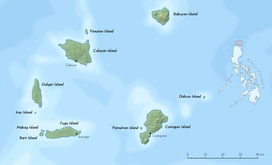
345:Babuyan Claro in the background and
987:Active volcanoes of the Philippines
75:Active volcanoes in the Philippines
967:Stratovolcanoes of the Philippines
14:
334:. It is classified as one of the
169:
162:
139:
132:
34:
326:, north of the main island of
1:
977:Volcanoes of the Luzon Strait
437:said the earthquakes were of
982:Mountains of the Philippines
819:Potentially active volcanoes
611:Volcanoes of the Philippines
372:(Region II) of the country.
63:1,007 m (3,304 ft)
53:1,007 m (3,304 ft)
1008:
633:List of inactive volcanoes
318:, the northernmost of the
16:Volcano in the Philippines
944:
617:
357:of Babuyan Claro, in the
294:
125:
33:
28:
623:List of active volcanoes
546:Global Volcanism Program
429:Recent reported activity
403:Global Volcanism Program
320:Babuyan group of islands
551:Smithsonian Institution
407:Smithsonian Institution
359:Municipality of Calayan
183:Show map of Philippines
350:
105:19.52333°N 121.94000°E
702:Laguna Volcanic Field
682:Camiguin de Babuyanes
344:
301:Babuyan Claro Volcano
24:Babuyan Claro Volcano
992:Landforms of Cagayan
972:Subduction volcanoes
516:on December 30, 2013
380:Babuyan Claro is a
110:19.52333; 121.94000
101: /
351:
43:Highest point
954:
953:
856:Cuernos de Negros
814:
813:
376:Physical features
365:province, in the
298:
297:
153:Show map of Luzon
999:
781:Leonard Kniaseff
647:
643:Active volcanoes
604:
597:
590:
581:
571:
568:
562:
561:
559:
557:
537:
526:
525:
523:
521:
512:. Archived from
499:
336:active volcanoes
303:, also known as
184:
173:
172:
166:
154:
143:
142:
136:
116:
115:
113:
112:
111:
106:
102:
99:
98:
97:
94:
77:
38:
21:
1007:
1006:
1002:
1001:
1000:
998:
997:
996:
957:
956:
955:
950:
940:
810:
759:
733:
638:
637:
613:
608:
577:
575:
574:
569:
565:
555:
553:
541:"Babuyan Claro"
539:
538:
529:
519:
517:
503:"Babuyan Claro"
501:
500:
485:
480:
451:
431:
419:phreatomagmatic
399:
391:sodium chloride
378:
258:– 1480+/-50 B.P
189:
188:
187:
186:
185:
182:
181:
180:
179:
178:
174:
157:
156:
155:
152:
151:
150:
149:
148:
144:
109:
107:
103:
100:
95:
92:
90:
88:
87:
73:
17:
12:
11:
5:
1005:
1003:
995:
994:
989:
984:
979:
974:
969:
959:
958:
952:
951:
945:
942:
941:
939:
938:
933:
928:
923:
918:
913:
908:
903:
898:
893:
888:
883:
881:Laguna Caldera
878:
873:
868:
863:
858:
853:
848:
843:
838:
833:
828:
822:
820:
816:
815:
812:
811:
809:
808:
803:
798:
793:
788:
783:
778:
773:
767:
765:
761:
760:
758:
757:
752:
747:
741:
739:
735:
734:
732:
731:
724:
719:
714:
709:
704:
699:
694:
689:
684:
679:
674:
669:
664:
659:
653:
651:
644:
640:
639:
636:
635:
630:
625:
619:
618:
615:
614:
609:
607:
606:
599:
592:
584:
573:
572:
563:
527:
482:
481:
479:
476:
475:
474:
473:
472:
467:
462:
450:
447:
435:volcanologists
430:
427:
398:
395:
377:
374:
367:Cagayan Valley
316:Babuyan Island
305:Mount Pangasun
296:
295:
292:
291:
288:
282:
281:
278:
272:
271:
266:
260:
259:
252:
246:
245:
241:
240:
235:
225:
224:
219:
213:
212:
210:Cagayan Valley
207:
201:
200:
195:
191:
190:
176:
175:
168:
167:
161:
160:
159:
158:
146:
145:
138:
137:
131:
130:
129:
128:
127:
126:
123:
122:
118:
117:
85:
79:
78:
71:
65:
64:
61:
55:
54:
51:
45:
44:
40:
39:
31:
30:
29:Mount Pangasun
26:
25:
15:
13:
10:
9:
6:
4:
3:
2:
1004:
993:
990:
988:
985:
983:
980:
978:
975:
973:
970:
968:
965:
964:
962:
949:
943:
937:
934:
932:
929:
927:
926:San Cristobal
924:
922:
919:
917:
914:
912:
909:
907:
904:
902:
899:
897:
894:
892:
889:
887:
884:
882:
879:
877:
874:
872:
869:
867:
864:
862:
859:
857:
854:
852:
849:
847:
844:
842:
839:
837:
834:
832:
829:
827:
824:
823:
821:
817:
807:
804:
802:
799:
797:
794:
792:
789:
787:
784:
782:
779:
777:
774:
772:
769:
768:
766:
762:
756:
753:
751:
748:
746:
743:
742:
740:
736:
730:
729:
725:
723:
720:
718:
715:
713:
710:
708:
705:
703:
700:
698:
695:
693:
690:
688:
685:
683:
680:
678:
675:
673:
670:
668:
665:
663:
660:
658:
657:Babuyan Claro
655:
654:
652:
648:
645:
641:
634:
631:
629:
626:
624:
621:
620:
616:
612:
605:
600:
598:
593:
591:
586:
585:
582:
578:
567:
564:
552:
548:
547:
542:
536:
534:
532:
528:
515:
511:
509:
504:
498:
496:
494:
492:
490:
488:
484:
477:
471:
468:
466:
463:
461:
458:
457:
456:
453:
452:
448:
446:
442:
440:
436:
428:
426:
424:
420:
416:
412:
411:Smith Volcano
408:
404:
396:
394:
392:
386:
383:
382:stratovolcano
375:
373:
371:
368:
364:
360:
356:
348:
347:Smith Volcano
343:
339:
337:
333:
329:
325:
321:
317:
313:
310:
306:
302:
293:
289:
287:
286:Last eruption
283:
279:
277:
273:
270:
269:Stratovolcano
267:
265:
264:Mountain type
261:
257:
253:
251:
247:
242:
239:
236:
234:
230:
226:
223:
220:
218:
214:
211:
208:
206:
202:
199:
196:
192:
177:Babuyan Claro
165:
147:Babuyan Claro
135:
124:
119:
114:
86:
84:
80:
76:
72:
70:
66:
62:
60:
56:
52:
50:
46:
41:
37:
32:
27:
22:
19:
726:
656:
576:
566:
556:December 30,
554:. Retrieved
544:
520:December 26,
518:. Retrieved
514:the original
506:
443:
432:
400:
387:
379:
352:
324:Luzon Strait
304:
300:
299:
276:Volcanic arc
254:2.32+/-0.35
233:municipality
18:
931:Santo Tomas
771:Hibok-Hibok
415:strombolian
349:foreground.
332:Philippines
314:located on
250:Age of rock
198:Philippines
108: /
96:121°56′24″E
83:Coordinates
961:Categories
946:See also:
906:Mandalagan
871:Kalatungan
851:Cancajanag
786:Makaturing
776:Jolo Group
510:(PHIVOLCS)
478:References
93:19°31′24″N
59:Prominence
911:Mariveles
841:Balatukan
397:Eruptions
121:Geography
49:Elevation
901:Malindig
891:Mahagnao
764:Mindanao
750:Cabalian
712:Pinatubo
667:Binuluan
449:See also
439:tectonic
355:Barangay
307:, is an
217:Province
896:Malinao
886:Latukan
826:Amorong
791:Matutum
755:Kanlaon
745:Biliran
738:Visayas
728:Unnamed
687:Didicas
672:Bulusan
662:Banahaw
421:by the
405:of the
393:brine.
363:Cagayan
330:in the
312:volcano
244:Geology
238:Calayan
222:Cagayan
194:Country
69:Listing
866:Isarog
836:Arayat
806:Ragang
801:Parker
796:Musuan
370:Region
309:active
205:Region
936:Silay
921:Panay
916:Natib
861:Dakut
846:Balut
717:Smith
707:Mayon
697:Iriga
692:Iraya
677:Cagua
650:Luzon
328:Luzon
876:Labo
722:Taal
558:2009
522:2013
290:1924
229:City
831:Apo
417:or
322:in
963::
549:.
543:.
530:^
505:.
486:^
425:.
361:,
256:Ma
603:e
596:t
589:v
560:.
524:.
231:/
Text is available under the Creative Commons Attribution-ShareAlike License. Additional terms may apply.