625:
765:. A small bay indenting the east shore of Andvord Bay 6 nautical miles (11 km; 6.9 mi) southeast of Beneden Head. First seen and roughly charted by the BelgAE under Gerlache, 1897-99. Named after Messrs. Chr. Salvesen's floating factory Neko, which operated in the South Shetland Islands and Antarctic Peninsula area for many seasons between 1911-12 and 1923-24, and which often used this bay. The name was published by the Scottish geologist David Ferguson in 1921, following his visit to this area in 1913.
56:
40:
981:
722:
186:
896:. Situated 11.15 kilometres (6.93 mi) east-southeast of Mount Inverleith. Surmounts Bagshawe Glacier to the southwest, and Andvord Bay and its southernmost part Lester Cove to the north where the ridge ends in Forbes Point. Named after the Bulgarian industrialist Lachezar Tsotsorkov for his sustained support for the Bulgarian Antarctic programme.
63:
324:
1602:
237:, Fliess Glacier (which enters Neko Harbour), Arago Glacier, Moser Glacier, Rudolph Glacier, Bagshawe Glacier and Grubb Glacier. Coastal features, clockwise from the northeast, include Beneden Head, Neko Harbour, Henryk Cove, Forbes Point, Lester Cove, Dallmeyer Peak, Almirante Ice Fringe, Steinheil Point, Mount Hoegh and Duthiers Point.
1156:. A point 5 nautical miles (9.3 km; 5.8 mi) southeast of Duthiers Point on the west side of Andvord Bay. First roughly charted by the BelgAE under Gerlache, 1897-99. Named by the UK-APC in 1960 for Hugo Adolph Steinheil (1832–93), German mathematical optician who designed and introduced an improved
608:. A glacier which drains the northeast slopes of Mount Theodore and discharges into Lester Cove. The mouth of the glacier was first seen and sketched by the Belgian Antarctic Expedition (BelgAE) in February 1898. The glacier was first roughly surveyed by K.V. Blaiklock of FIDS from the
1647:(REMA) gives ice surface measurements of most of the continent. When a feature is ice-covered, the ice surface will differ from the underlying rock surface and will change over time. To see ice surface contours and elevation of a feature as of the last REMA update,
972:. A mountain 4 nautical miles (7.4 km; 4.6 mi) southeast of Mount Inverleith on the south side of Bagshawe Glacier. Named by Scottish geologist David Ferguson who made a geological reconnaissance in this vicinity from the whale catcher Hanka in 1913.
261:
driven by ocean water. Relatively little meltwater enters the bay, although some freshening can be detected near the surface in the summer. The lack of strong wind combined with the surface freshing cause stratification of salinity to a significant depth in the
1064:. A peak, 1,105 metres (3,625 ft) high, standing 2 nautical miles (3.7 km; 2.3 mi) southwest of Steinheil Point on the south side of Andvord Bay. The peak appears on an Argentine government chart of 1952. Named by the UK-APC in 1960 for
1198:. A mountain, 890 metres (2,920 ft) high, standing 1.5 nautical miles (2.8 km; 1.7 mi) south-southeast of Duthiers Point on the west coast of Graham Land. Charted by the BelgAE under Gerlache, 1897-99. Named by the UK-APC in 1960 for
1919:
312:. The study conducted research cruises to Andvord Bay in November-December 2015, April 2016, and March-April 2017 to evaluate physical oceanographic processes, glacial inputs, plankton dynamics, and benthic community structure and function in the bay.
934:. A cove forming the southernmost part of Andvord Bay. Charted by the BelgAE under Gerlache, 1897-99. Named by the UK-APC in 1960 for Maxime C. Lester (1891-1957), who, with T.W. Bagshawe, wintered at nearby Waterboat Point in 1921.
1606:
852:
in 1913-14 to a corner or spur of the plateau escarpment which is not a definable feature. From it, however, a ridge runs down to a prominent point useful for reference purposes, to which the name Forbes has been applied.
1916:
891:
A rocky, partly ice-covered mountain extending 7.6 kilometres (4.7 mi) in a north–south direction, 3 kilometres (1.9 mi) wide and rising to 1,615 metres (5,299 ft) in the northwest foothills of
173:) is a bay, 9 nautical miles (17 km; 10 mi) long and 3 nautical miles (5.6 km; 3.5 mi) wide, which lies between Beneden Head and Duthiers Point along the west coast of
709:. A steep-sided headland, 700 metres (2,300 ft) high, forming the north side of the entrance to Andvord Bay. Discovered by the BelgAE, 1897-99, and named after Professor
1018:. A mountain, 1,495 metres (4,905 ft) high, standing near the edge of the plateau escarpment 2 nautical miles (3.7 km; 2.3 mi) east-northeast of the head of
257:
from the
Gerlache Strait into the fjord. The fjord therefore has cold deep water compared to bays further south, and its glaciers mainly lose ice through calving rather than
662:. Glacier flowing into Lester Cove to the west of Bagshawe Glacier. The glacier appears on an Argentine government chart of 1952. Named by the UK-APC in 1960 for
1240:. A point forming the south side of the entrance to Andvord Bay. Discovered by the BelgAE, 1897-99, under Gerlache, who named it "Cap Lacaze-Duthiers" for
1902:
1845:
1769:
1627:
1870:
Lundesgaard, Øyvind; Winsor, Peter; Truffer, Martin; Merrifield, Mark; Powell, Brian; Statscewich, Hank; Eidam, Emily; Smith, Craig R. (February 2020),
470:. Glacier flowing into Andvord Bay just southeast of Arago Glacier. Charted by the BelgAE under Gerlache, 1897-99. Named by the UK-APC in 1960 for
1659:
The coordinates should be in DMS format, e.g. 65°05'03"S 64°01'02"W. If you only have degrees and minutes, you may not be able to locate the feature.
88:
1644:
1610:
55:
624:
558:. Glacier flowing into Andvord Bay south of Moser Glacier. Charted by the BelgAE under Gerlache, 1897-99. Named by the UK-APC in 1960 for
1931:
413:
1692:
The "Identify" box will appear to the top left. The
Orthometric height is the elevation of the ice surface of the feature at this point.
421:
1897:
1840:
1764:
1622:
136:
1241:
1106:
A narrow ice piedmont bordering the southwest side of
Andvord Bay. Named by the Polish Antarctic Expedition, about 1995, after
516:. The 4 nautical miles (7.4 km; 4.6 mi) long icefalls overlook the east-most cove of Andvord Bay. Named by the
1950:
848:. A point forming the east side of the entrance to Lester Cove. The name Forbes Hill was given by Scottish geologist
279:
1776:
Cusick, Allison M.; Gilmore, Robert; Bombosch, Annette; Mascioni, Martina; Almandoz, Gastón O.; Vernet, Maria (2020).
517:
309:
1078:
863:
778:
484:
1023:
849:
327:
1656:
Enter the feature's coordinates in the box at the top left that says "Find address or place", then press enter
559:
1212:
1170:
1128:
1068:(1830-83), English (formerly German) optician who independently developed the "rectilinear|photographic lens.
1036:
990:
944:
906:
820:
737:
681:
634:
580:
530:
442:
384:
339:
1719:
1715:
1107:
1871:
1202:(1865-1915), German mathematical optician who designed the first double anastigmatic camera lens in 1893.
254:
713:, president of the Belgica Commission and author of several of the zoological reports of the expedition.
287:
1892:
1835:
1759:
1617:
1955:
1065:
471:
1819:
1111:
710:
417:
210:
198:
44:
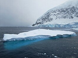
A small iceberg floats in the clear cold waters of
Andvord Bay with the Antarctic Peninsula beyond.
366:
1928:
1807:
1778:"POLAR TOURISM AS AN EFFECTIVE RESEARCH TOOL: Citizen Science in the Western Antarctic Peninsula"
283:
666:(1800-78), Irish optician who designed and introduced the first aplanatic camera lens, in 1857.
361:
1872:"Hydrography and energetics of a cold subpolar fjord: Andvord Bay, western Antarctic Peninsula"
1799:
893:
513:
425:
206:
202:
1789:
807:
356:
303:
230:
39:
1935:
1923:
1681:
You can zoom in and out to see the ice surface contours of the feature and nearby features
1115:
258:
234:
218:
214:
1705:
1651:
980:
1199:
616:
who, with Maxime
Charles Lester, wintered at Waterboat Point near Andvord Bay in 1921.
613:
233:
are to the southwest. Glaciers entering the bay, clockwise from the northeast, include
226:
1944:
1019:
567:
267:
246:
222:
412:. Glacier flowing into Andvord Bay just northwest of Moser Glacier. Mapped by the
1670:
In the bottom right of the screen, set "Shading Factor" to 0 to get a clearer image
1584:
730:
663:
250:
1853:"FjordEco: Fjord Ecosystem Structure and function on the west Antarctic Peninsula"
1734:
1857:
FjordEco: Fjord
Ecosystem Structure and function on the west Antarctic Peninsula
308:
The FjordEco
Project is an integrated field and modeling study supported by the
263:
194:
174:
17:
1689:
Click the point where the contour lines seem to indicate the top of the feature
563:
1803:
1794:
1777:
1227:
1214:
1185:
1172:
1143:
1130:
1093:
1080:
1051:
1038:
1005:
992:
959:
946:
921:
908:
878:
865:
835:
822:
793:
780:
752:
739:
696:
683:
649:
636:
595:
582:
545:
532:
499:
486:
457:
444:
399:
386:
152:
138:
104:
90:
1157:
432:
who first demonstrated the application of photography to mapmaking in 1839.
429:
474:(1805-80), German physicist who invented stereoscopic photography in 1844.
351:
1811:
185:
1245:
1710:(Digital Elevation Models created by the Polar Geospatial Center from
721:
1735:"Geology of Gerlache Strait, West Antarctica. I. Arctowski Peninsula"
1160:
camera lens in 1866 and, independently, the telephoto lens in 1891.
323:
1852:
1711:
1302:
979:
623:
184:
1022:. First charted and named Iverleith Hill by Scottish geologist
291:
1244:(1821-1901), French naturalist and authority on the anatomy of
628:
Grubb
Glacier, pictured at center, flanked by Mount Inverleith.
1278:
1678:
In the "Contour properties" box, select
Contour Interval = 1m
1422:
570:
in 1889, and the "Tessar" lens, introduced by Zeiss in 1902.
1917:
Andvord Bay water temperature, salinity, pressure database
253:
that restricts movement of relatively warm upper layer of
189:
Danco Coast, Antarctic
Peninsula. Andvord Bay to the west
810:, member of the 1897-1899 Belgian Antarctic Expedition.
1262:
1260:
562:, German mathematical optician who designed the first
249:. The mouth of Andvord Bay is just to the north of an
1592:(2 ed.), United States Board on Geographic Names
1530:
806:. A cove in inner part of Andvord Bay. Named after
1458:
768:Neko Harbour is a popular cruise-ship destination.
512:. Steep icefalls of blue ice on the west margin of
80:
32:
1470:
217:are to the east of the bay, which opens onto the
81:
1929:Andvord Bay long term updated weather forecast
1664:Hover over the icons at the left of the screen
1350:
8:
1434:
1290:
201:. It extands in a northwest direction from
1903:Scientific Committee on Antarctic Research
1846:Scientific Committee on Antarctic Research
1770:Scientific Committee on Antarctic Research
1634:
1628:Scientific Committee on Antarctic Research
29:
1793:
310:United States National Science Foundation
720:
1645:Reference Elevation Model of Antarctica
1611:United States Board on Geographic Names
1566:
1554:
1542:
1518:
1506:
1494:
1482:
1446:
1410:
1398:
1386:
1374:
1362:
1338:
1326:
1266:
1256:
1821:Graham Land and South Shetland Islands
612:in April 1955. Named by UK-APC after
1824:, BAS: British Antarctic Survey, 2005
7:
1314:
984:Windswept summit of Mount Inverleith
414:Falkland Islands Dependencies Survey
1667:Find "Hillshade" and click on that
725:Glacier in Neko Harbour, Antarctica
62:
1686:Find "Identify" and click on that
1609:from websites or documents of the
1279:Graham Land and South Shetland BAS
422:UK Antarctic Place-Names Committee
278:Andvord Bay was discovered by the
25:
1898:Composite Gazetteer of Antarctica
1841:Composite Gazetteer of Antarctica
1765:Composite Gazetteer of Antarctica
1675:Find "Contour" and click on that
1623:Composite Gazetteer of Antarctica
1586:Geographic Names of the Antarctic
328:Copernix annotated satellite view
1605: This article incorporates
1600:
416:(FIDS) from air photos taken by
322:
61:
54:
38:
420:Ltd. in 1956-57. Named by the
1733:Birkenmajer, Krzystof (1995),
1583:Alberts, Fred G., ed. (1995),
1242:Félix Henri de Lacaze-Duthiers
1:
280:Belgian Antarctic Expedition
566:camera lens, introduced by
518:Polish Antarctic Expedition
367:GPX (secondary coordinates)
1972:
728:
301:
1531:Almirante Ice Fringe SCAR
362:GPX (primary coordinates)
337:Map all coordinates using
282:(BelgAE), 1897–99, under
49:
37:
1876:Progress in Oceanography
1795:10.5670/oceanog.2020.101
1461:, 64°56′23″S 62°31′17″W.
345:Download coordinates as:
266:. This is hospitable to
197:on the west side of the
1720:University of Minnesota
1716:Polar Geospatial Center
1707:Antarctic REMA Explorer
1652:Antarctic REMA Explorer
1459:Antarctic REMA Explorer
1303:Lundesgaard et al. 2020
1108:Almirante Brown Station
286:, and named by him for
1618:"Almirante Ice Fringe"
1607:public domain material
1110:(Argentine) on nearby
985:
726:
629:
255:circumpolar deep water
193:Andvord Bay is on the
190:
1742:Polish Polar Research
1471:Mount Tsotsorkov SCAR
1094:64.86667°S 62.68333°W
983:
879:64.93972°S 62.52139°W
794:64.85833°S 62.40000°W
724:
627:
500:64.90000°S 62.33333°W
424:(UK-APC) in 1960 for
357:GPX (all coordinates)
188:
1099:-64.86667; -62.68333
1072:Almirante Ice Fringe
1066:John Henry Dallmeyer
884:-64.93972; -62.52139
799:-64.85833; -62.40000
505:-64.90000; -62.33333
428:(1786-1853), French
290:, Belgian consul at
1951:Bays of Graham Land
1224: /
1182: /
1140: /
1112:Coughtrey Peninsula
1090: /
1048: /
1002: /
956: /
918: /
875: /
832: /
790: /
749: /
711:Edouard Van Beneden
693: /
646: /
592: /
542: /
496: /
454: /
418:Hunting Aerosurveys
396: /
211:Arctowski Peninsula
199:Antarctic Peninsula
148: /
100: /
1934:2020-03-23 at the
1922:2020-03-23 at the
1893:"Mount Tsotsorkov"
1423:Cusick et al. 2020
1351:Blue Icefalls SCAR
986:
727:
630:
292:Christiania (Oslo)
284:Adrien de Gerlache
274:Discovery and name
191:
1700:
1699:
1228:64.800°S 62.817°W
1186:64.833°S 62.800°W
1144:64.850°S 62.683°W
1052:64.883°S 62.750°W
1006:64.917°S 62.750°W
960:64.967°S 62.600°W
922:64.900°S 62.600°W
894:Forbidden Plateau
836:64.883°S 62.550°W
753:64.833°S 62.550°W
697:64.767°S 62.700°W
650:64.933°S 62.633°W
596:64.933°S 62.583°W
546:64.900°S 62.433°W
514:Forbidden Plateau
458:64.850°S 62.367°W
400:64.850°S 62.383°W
245:Andvord Bay is a
207:Laussedat Heights
203:Forbidden Plateau
153:64.833°S 62.650°W
128:
127:
105:64.833°S 62.650°W
27:Bay in Antarctica
16:(Redirected from
1963:
1905:
1888:
1887:
1886:
1866:
1864:
1863:
1848:
1831:
1830:
1829:
1815:
1797:
1772:
1755:
1754:
1753:
1739:
1729:
1728:
1727:
1635:
1630:
1604:
1603:
1599:
1598:
1597:
1591:
1570:
1564:
1558:
1552:
1546:
1540:
1534:
1528:
1522:
1516:
1510:
1504:
1498:
1492:
1486:
1480:
1474:
1468:
1462:
1456:
1450:
1444:
1438:
1435:Henryk Cove SCAR
1432:
1426:
1420:
1414:
1408:
1402:
1396:
1390:
1384:
1378:
1372:
1366:
1360:
1354:
1348:
1342:
1336:
1330:
1324:
1318:
1312:
1306:
1300:
1294:
1291:Birkenmajer 1995
1288:
1282:
1276:
1270:
1264:
1239:
1238:
1236:
1235:
1234:
1233:-64.800; -62.817
1229:
1225:
1222:
1221:
1220:
1217:
1197:
1196:
1194:
1193:
1192:
1191:-64.833; -62.800
1187:
1183:
1180:
1179:
1178:
1175:
1155:
1154:
1152:
1151:
1150:
1149:-64.850; -62.683
1145:
1141:
1138:
1137:
1136:
1133:
1105:
1104:
1102:
1101:
1100:
1095:
1091:
1088:
1087:
1086:
1083:
1063:
1062:
1060:
1059:
1058:
1057:-64.883; -62.750
1053:
1049:
1046:
1045:
1044:
1041:
1017:
1016:
1014:
1013:
1012:
1011:-64.917; -62.750
1007:
1003:
1000:
999:
998:
995:
976:Mount Inverleith
971:
970:
968:
967:
966:
965:-64.967; -62.600
961:
957:
954:
953:
952:
949:
933:
932:
930:
929:
928:
927:-64.900; -62.600
923:
919:
916:
915:
914:
911:
890:
889:
887:
886:
885:
880:
876:
873:
872:
871:
868:
857:Mount Tsotsorkov
847:
846:
844:
843:
842:
841:-64.883; -62.550
837:
833:
830:
829:
828:
825:
808:Henryk Arctowski
805:
804:
802:
801:
800:
795:
791:
788:
787:
786:
783:
764:
763:
761:
760:
759:
758:-64.833; -62.550
754:
750:
747:
746:
745:
742:
708:
707:
705:
704:
703:
702:-64.767; -62.700
698:
694:
691:
690:
689:
686:
661:
660:
658:
657:
656:
655:-64.933; -62.633
651:
647:
644:
643:
642:
639:
607:
606:
604:
603:
602:
601:-64.933; -62.583
597:
593:
590:
589:
588:
585:
574:Bagshawe Glacier
557:
556:
554:
553:
552:
551:-64.900; -62.433
547:
543:
540:
539:
538:
535:
511:
510:
508:
507:
506:
501:
497:
494:
493:
492:
489:
469:
468:
466:
465:
464:
463:-64.850; -62.367
459:
455:
452:
451:
450:
447:
411:
410:
408:
407:
406:
405:-64.850; -62.383
401:
397:
394:
393:
392:
389:
326:
304:FjordEco Project
298:FjordEco Project
231:Paradise Harbour
172:
171:
169:
168:
167:
165:
160:
159:
158:-64.833; -62.650
154:
149:
146:
145:
144:
141:
124:
123:
121:
120:
119:
117:
112:
111:
110:-64.833; -62.650
106:
101:
98:
97:
96:
93:
83:
65:
64:
58:
42:
30:
21:
18:Bagshawe Glacier
1971:
1970:
1966:
1965:
1964:
1962:
1961:
1960:
1941:
1940:
1936:Wayback Machine
1924:Wayback Machine
1913:
1908:
1891:
1884:
1882:
1869:
1861:
1859:
1851:
1834:
1827:
1825:
1818:
1775:
1760:"Blue Icefalls"
1758:
1751:
1749:
1737:
1732:
1725:
1723:
1704:
1701:
1616:
1601:
1595:
1593:
1589:
1582:
1578:
1573:
1565:
1561:
1553:
1549:
1541:
1537:
1529:
1525:
1517:
1513:
1505:
1501:
1493:
1489:
1481:
1477:
1469:
1465:
1457:
1453:
1445:
1441:
1433:
1429:
1421:
1417:
1409:
1405:
1397:
1393:
1385:
1381:
1373:
1369:
1361:
1357:
1349:
1345:
1337:
1333:
1325:
1321:
1313:
1309:
1301:
1297:
1289:
1285:
1277:
1273:
1265:
1258:
1254:
1232:
1230:
1226:
1223:
1218:
1215:
1213:
1211:
1210:
1208:
1190:
1188:
1184:
1181:
1176:
1173:
1171:
1169:
1168:
1166:
1148:
1146:
1142:
1139:
1134:
1131:
1129:
1127:
1126:
1124:
1122:Steinheil Point
1116:Paradise Harbor
1098:
1096:
1092:
1089:
1084:
1081:
1079:
1077:
1076:
1074:
1056:
1054:
1050:
1047:
1042:
1039:
1037:
1035:
1034:
1032:
1010:
1008:
1004:
1001:
996:
993:
991:
989:
988:
978:
964:
962:
958:
955:
950:
947:
945:
943:
942:
940:
926:
924:
920:
917:
912:
909:
907:
905:
904:
902:
883:
881:
877:
874:
869:
866:
864:
862:
861:
859:
840:
838:
834:
831:
826:
823:
821:
819:
818:
816:
798:
796:
792:
789:
784:
781:
779:
777:
776:
774:
757:
755:
751:
748:
743:
740:
738:
736:
735:
733:
719:
701:
699:
695:
692:
687:
684:
682:
680:
679:
677:
672:
654:
652:
648:
645:
640:
637:
635:
633:
632:
622:
600:
598:
594:
591:
586:
583:
581:
579:
578:
576:
550:
548:
544:
541:
536:
533:
531:
529:
528:
526:
524:Rudolph Glacier
504:
502:
498:
495:
490:
487:
485:
483:
482:
480:
472:Ludwig F. Moser
462:
460:
456:
453:
448:
445:
443:
441:
440:
438:
404:
402:
398:
395:
390:
387:
385:
383:
382:
380:
375:
374:
373:
372:
371:
332:
331:
330:
318:
306:
300:
276:
259:glacial retreat
243:
235:Deville Glacier
219:Gerlache Strait
183:
163:
161:
157:
155:
151:
150:
147:
142:
139:
137:
135:
134:
115:
113:
109:
107:
103:
102:
99:
94:
91:
89:
87:
86:
76:
75:
74:
73:
72:
71:
70:
66:
45:
28:
23:
22:
15:
12:
11:
5:
1969:
1967:
1959:
1958:
1953:
1943:
1942:
1939:
1938:
1926:
1912:
1911:External links
1909:
1907:
1906:
1889:
1867:
1849:
1832:
1816:
1773:
1756:
1730:
1698:
1697:
1696:
1695:
1694:
1693:
1690:
1684:
1683:
1682:
1679:
1673:
1672:
1671:
1665:
1662:
1661:
1660:
1654:
1640:
1639:
1638:REMA Explorer
1633:
1632:
1631:
1614:
1579:
1577:
1574:
1572:
1571:
1569:, p. 206.
1559:
1557:, p. 338.
1547:
1545:, p. 710.
1535:
1523:
1511:
1509:, p. 362.
1499:
1497:, p. 741.
1487:
1485:, p. 429.
1475:
1463:
1451:
1449:, p. 250.
1439:
1427:
1415:
1413:, p. 519.
1403:
1391:
1389:, p. 298.
1379:
1367:
1365:, p. 635.
1355:
1343:
1341:, p. 507.
1331:
1319:
1307:
1295:
1293:, p. 48b.
1283:
1271:
1255:
1253:
1250:
1207:
1206:Duthiers Point
1204:
1200:Emil von Hoegh
1165:
1162:
1123:
1120:
1073:
1070:
1031:
1030:Dallmeyer Peak
1028:
1024:David Ferguson
977:
974:
939:
938:Mount Theodore
936:
901:
898:
858:
855:
850:David Ferguson
815:
812:
773:
770:
729:Main article:
718:
715:
676:
673:
671:
670:Other features
668:
621:
618:
614:T. W. Bagshawe
575:
572:
525:
522:
520:, about 1995.
479:
476:
437:
434:
426:François Arago
379:
376:
370:
369:
364:
359:
354:
348:
342:
335:
334:
333:
321:
320:
319:
317:
314:
302:Main article:
299:
296:
294:at that time.
275:
272:
242:
239:
227:Lemaire Island
182:
179:
177:, Antarctica.
126:
125:
84:
78:
77:
68:
67:
60:
59:
53:
52:
51:
50:
47:
46:
43:
35:
34:
26:
24:
14:
13:
10:
9:
6:
4:
3:
2:
1968:
1957:
1954:
1952:
1949:
1948:
1946:
1937:
1933:
1930:
1927:
1925:
1921:
1918:
1915:
1914:
1910:
1904:
1900:
1899:
1894:
1890:
1881:
1877:
1873:
1868:
1858:
1854:
1850:
1847:
1843:
1842:
1837:
1836:"Henryk Cove"
1833:
1823:
1822:
1817:
1813:
1809:
1805:
1801:
1796:
1791:
1787:
1783:
1779:
1774:
1771:
1767:
1766:
1761:
1757:
1747:
1743:
1736:
1731:
1721:
1717:
1713:
1709:
1708:
1703:
1702:
1691:
1688:
1687:
1685:
1680:
1677:
1676:
1674:
1669:
1668:
1666:
1663:
1658:
1657:
1655:
1653:
1649:
1648:
1646:
1642:
1641:
1637:
1636:
1629:
1625:
1624:
1619:
1615:
1612:
1608:
1588:
1587:
1581:
1580:
1575:
1568:
1563:
1560:
1556:
1551:
1548:
1544:
1539:
1536:
1532:
1527:
1524:
1520:
1515:
1512:
1508:
1503:
1500:
1496:
1491:
1488:
1484:
1479:
1476:
1472:
1467:
1464:
1460:
1455:
1452:
1448:
1443:
1440:
1436:
1431:
1428:
1424:
1419:
1416:
1412:
1407:
1404:
1401:, p. 58.
1400:
1395:
1392:
1388:
1383:
1380:
1377:, p. 39.
1376:
1371:
1368:
1364:
1359:
1356:
1352:
1347:
1344:
1340:
1335:
1332:
1329:, p. 24.
1328:
1323:
1320:
1316:
1311:
1308:
1304:
1299:
1296:
1292:
1287:
1284:
1280:
1275:
1272:
1269:, p. 21.
1268:
1263:
1261:
1257:
1251:
1249:
1247:
1243:
1237:
1205:
1203:
1201:
1195:
1163:
1161:
1159:
1153:
1121:
1119:
1117:
1113:
1109:
1103:
1071:
1069:
1067:
1061:
1029:
1027:
1025:
1021:
1020:Skontorp Cove
1015:
982:
975:
973:
969:
937:
935:
931:
899:
897:
895:
888:
856:
854:
851:
845:
813:
811:
809:
803:
771:
769:
766:
762:
732:
723:
716:
714:
712:
706:
674:
669:
667:
665:
659:
626:
620:Grubb Glacier
619:
617:
615:
611:
605:
573:
571:
569:
568:Carl Zeiss AG
565:
561:
555:
523:
521:
519:
515:
509:
478:Blue Icefalls
477:
475:
473:
467:
436:Moser Glacier
435:
433:
431:
427:
423:
419:
415:
409:
378:Arago Glacier
377:
368:
365:
363:
360:
358:
355:
353:
350:
349:
347:
346:
341:
340:OpenStreetMap
338:
329:
325:
315:
313:
311:
305:
297:
295:
293:
289:
285:
281:
273:
271:
269:
268:phytoplankton
265:
260:
256:
252:
248:
247:glacial fjord
240:
238:
236:
232:
228:
224:
223:Anvers Island
220:
216:
212:
208:
204:
200:
196:
187:
180:
178:
176:
170:
132:
122:
85:
79:
57:
48:
41:
36:
31:
19:
1896:
1883:, retrieved
1879:
1875:
1860:. Retrieved
1856:
1839:
1826:, retrieved
1820:
1788:(1): 50–61.
1785:
1782:Oceanography
1781:
1763:
1750:, retrieved
1748:(1–2): 47–60
1745:
1741:
1724:, retrieved
1706:
1621:
1594:, retrieved
1585:
1567:Alberts 1995
1562:
1555:Alberts 1995
1550:
1543:Alberts 1995
1538:
1526:
1519:Alberts 1995
1514:
1507:Alberts 1995
1502:
1495:Alberts 1995
1490:
1483:Alberts 1995
1478:
1466:
1454:
1447:Alberts 1995
1442:
1430:
1418:
1411:Alberts 1995
1406:
1399:Alberts 1995
1394:
1387:Alberts 1995
1382:
1375:Alberts 1995
1370:
1363:Alberts 1995
1358:
1346:
1339:Alberts 1995
1334:
1327:Alberts 1995
1322:
1310:
1298:
1286:
1274:
1267:Alberts 1995
1209:
1167:
1125:
1075:
1033:
1026:in 1913-14.
987:
941:
903:
860:
817:
814:Forbes Point
775:
767:
734:
731:Neko Harbour
717:Neko Harbour
678:
675:Beneden Head
664:Thomas Grubb
631:
609:
577:
560:Paul Rudolph
527:
481:
439:
381:
344:
343:
336:
307:
288:Rolf Andvord
277:
251:aquatic sill
244:
215:Rongé Island
192:
130:
129:
1956:Danco Coast
1231: /
1189: /
1164:Mount Hoegh
1147: /
1097: /
1055: /
1009: /
963: /
925: /
900:Lester Cove
882: /
839: /
797: /
772:Henryk Cove
756: /
700: /
653: /
599: /
549: /
503: /
461: /
403: /
264:photic zone
241:Hydrography
195:Danco Coast
175:Graham Land
164:Andvord Bay
156: /
131:Andvord Bay
116:Andvord Bay
108: /
82:Coordinates
69:Andvord Bay
33:Andvord Bay
1945:Categories
1885:2024-05-28
1862:2021-10-18
1828:2024-05-03
1752:2024-05-28
1726:2024-06-03
1714:imagery),
1650:Open the
1596:2023-12-03
1252:References
1085:62°41′00″W
1082:64°52′00″S
870:62°31′17″W
867:64°56′23″S
785:62°24′00″W
782:64°51′30″S
564:anastigmat
491:62°20′00″W
488:64°54′00″S
162: (
114: (
1804:1042-8275
1158:aplanatic
430:geodesist
221:opposite
1932:Archived
1920:Archived
1812:26897835
1315:FjordEco
1246:mollusks
316:Glaciers
270:blooms.
181:Location
1576:Sources
1219:62°49′W
1216:64°48′S
1177:62°48′W
1174:64°50′S
1135:62°41′W
1132:64°51′S
1043:62°45′W
1040:64°53′S
997:62°45′W
994:64°55′S
951:62°36′W
948:64°58′S
913:62°36′W
910:64°54′S
827:62°33′W
824:64°53′S
744:62°33′W
741:64°50′S
688:62°42′W
685:64°46′S
641:62°38′W
638:64°56′S
587:62°35′W
584:64°56′S
537:62°26′W
534:64°54′S
449:62°22′W
446:64°51′S
391:62°23′W
388:64°51′S
209:on the
143:62°39′W
140:64°50′S
95:62°39′W
92:64°50′S
1810:
1802:
1722:, 2019
610:Norsel
1808:JSTOR
1738:(PDF)
1712:Maxar
1590:(PDF)
1800:ISSN
1643:The
229:and
213:and
1880:181
1790:doi
352:KML
1947::
1901:,
1895:,
1878:,
1874:,
1855:.
1844:,
1838:,
1806:.
1798:.
1786:33
1784:.
1780:.
1768:,
1762:,
1746:16
1744:,
1740:,
1718:,
1626:,
1620:,
1259:^
1248:.
1118:.
1114:,
225:.
205:.
1865:.
1814:.
1792::
1613:.
1533:.
1521:.
1473:.
1437:.
1425:.
1353:.
1317:.
1305:.
1281:.
166:)
133:(
118:)
20:)
Text is available under the Creative Commons Attribution-ShareAlike License. Additional terms may apply.