659:
67:
92:
50:
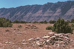
260:. The cairns are believed to have been built incrementally, with passer-by placing stones on the pile as a good luck offering. Much of the trail itself has been altered beyond recognition by the construction of an access road for area ranches. The trail runs along the western side of Bighorn Canyon. It is estimated to have been in use for ten to twelve thousand years. The trail features as many as one thousand
99:
74:
825:
588:
840:
835:
880:
865:
802:
875:
870:
619:
497:
860:
855:
695:
541:
830:
685:
850:
845:
806:
612:
713:
131:
648:
605:
490:
768:
667:
518:
510:
257:
658:
531:
680:
91:
788:
628:
506:
296:
268:
36:
241:. The trail ended at the mouth of Grapevine Creek on the Bighorn, from which the pack train could float down the Bighorn on rafts to the
483:
66:
783:
475:
718:
743:
526:
703:
733:
426:
225:
and was established in pre-Columbian times. After
Europeans arrived in the area it was frequented by fur trappers and
574:
640:
597:
675:
469:
358:
758:
632:
564:
738:
554:
301:
336:
250:
778:
559:
457:
315:
242:
222:
381:
463:
403:
119:
589:
National
Register of Historic Places listings in Bighorn Canyon National Recreation Area
773:
256:
Approximately three hundred cairns are known to exist along the trail, particularly in
246:
238:
230:
214:
177:
49:
819:
753:
723:
234:
210:
226:
382:"National Register of Historic Places Inventory - Nomination Form: Bad Pass Trail"
264:
on either side of the trail, some of which have been evaluated by archeologists.
748:
728:
826:
National
Register of Historic Places in Bighorn Canyon National Recreation Area
425:
Schieber, Laura L.; Finley, Judson Byrd; Boyle, Maureen P. (April–May 2008).
146:
133:
763:
569:
261:
841:
Archaeological sites on the
National Register of Historic Places in Montana
836:
Archaeological sites on the
National Register of Historic Places in Wyoming
229:, beginning in 1824. Trappers assembled pack trains at the junction of the
803:
National
Register of Historic Places listings in Big Horn County, Wyoming
217:-hunting grounds in the Grapevine Creek area of Montana. Marked by stone
206:
202:
316:"Bad Pass Trailpublisher=Wyoming State Historic Preservation Office"
201:, was established by Native Americans on the border of present-day
218:
291:
881:
National
Register of Historic Places in Big Horn County, Montana
866:
National
Register of Historic Places in Big Horn County, Wyoming
601:
479:
876:
Roads on the
National Register of Historic Places in Montana
871:
Roads on the
National Register of Historic Places in Wyoming
694:
666:
639:
540:
517:
183:
170:
162:
125:
115:
686:Paint Rock Canyon Archeological Landscape District
460:at the Wyoming State Historic Preservation Office
807:List of National Historic Landmarks in Wyoming
359:"Mountain Men and the Bad Pass Trail Timeline"
613:
491:
8:
861:Transportation in Big Horn County, Wyoming
856:Transportation in Big Horn County, Montana
714:Basin Republican-Rustler Printing Building
620:
606:
598:
498:
484:
476:
472:at Bighorn Canyon National Recreation Area
466:at Bighorn Canyon National Recreation Area
48:
831:Trails and roads in the American Old West
724:Bridger Immigrant Road-Dry Creek Crossing
54:Rock cairn on the Bad Pass Trail, Montana
37:U.S. National Register of Historic Places
511:Bighorn Canyon National Recreation Area
380:Mackenzie, George C. (August 1, 1974).
280:
258:Bighorn Canyon National Recreation Area
292:"National Register Information System"
286:
284:
98:
73:
20:
851:Geography of Big Horn County, Montana
846:Geography of Big Horn County, Wyoming
681:Black Mountain Archeological District
267:The Bad Pass Trail was placed on the
7:
629:National Register of Historic Places
507:National Register of Historic Places
297:National Register of Historic Places
269:National Register of Historic Places
237:, using the Bad Pass Trail to avoid
470:Mountain Men and the Bad Pass Trail
676:Big Horn Academy Historic District
14:
532:Fort C.F. Smith Historic District
657:
97:
90:
72:
65:
719:Bear Creek Ranch Medicine Wheel
575:Pretty Creek Archeological Site
166:5,372.3 acres (2,174.1 ha)
744:EJZ Bridge over Shoshone River
209:as a means of access from the
172:
1:
704:American Legion Hall, Post 32
106:Show map of the United States
789:US Post Office-Greybull Main
18:United States historic place
734:EJE Bridge over Shell Creek
897:
641:National Historic Landmark
147:45.0045972°N 108.2766389°W
797:
784:US Post Office-Basin Main
769:Medicine Lodge Creek Site
655:
583:
337:"Bad Pass Trail Timeline"
171:NRHP reference
59:
47:
43:
34:
27:
23:
759:Lower Shell School House
633:Big Horn County, Wyoming
152:45.0045972; -108.2766389
565:Caroline Lockhart Ranch
406:. National Park Service
384:. National Park Service
361:. National Park Service
339:. National Park Service
221:, the trail led across
739:EJP County Line Bridge
555:Bighorn Ditch Headgate
427:"Bad Pass Archaeology"
434:The American Surveyor
302:National Park Service
271:on October 29, 1975.
197:, also known as the
696:Historic properties
143: /
81:Show map of Montana
779:Southsider Shelter
668:Historic districts
519:Historic districts
813:
812:
595:
594:
560:Ewing-Snell Ranch
243:Yellowstone River
191:
190:
888:
661:
622:
615:
608:
599:
500:
493:
486:
477:
445:
444:
442:
440:
431:
422:
416:
415:
413:
411:
404:"Bad Pass Trail"
400:
394:
393:
391:
389:
377:
371:
370:
368:
366:
355:
349:
348:
346:
344:
333:
327:
326:
324:
322:
312:
306:
305:
288:
245:and then to the
187:October 29, 1975
174:
158:
157:
155:
154:
153:
148:
144:
141:
140:
139:
136:
107:
101:
100:
94:
82:
76:
75:
69:
52:
21:
896:
895:
891:
890:
889:
887:
886:
885:
816:
815:
814:
809:
793:
690:
662:
653:
635:
626:
596:
591:
579:
542:NRHP properties
536:
513:
504:
454:
449:
448:
438:
436:
429:
424:
423:
419:
409:
407:
402:
401:
397:
387:
385:
379:
378:
374:
364:
362:
357:
356:
352:
342:
340:
335:
334:
330:
320:
318:
314:
313:
309:
304:. July 9, 2010.
290:
289:
282:
277:
151:
149:
145:
142:
137:
134:
132:
130:
129:
120:Lovell, Wyoming
111:
110:
109:
108:
105:
104:
103:
102:
85:
84:
83:
80:
79:
78:
77:
55:
39:
30:
19:
12:
11:
5:
894:
892:
884:
883:
878:
873:
868:
863:
858:
853:
848:
843:
838:
833:
828:
818:
817:
811:
810:
798:
795:
794:
792:
791:
786:
781:
776:
774:Rairden Bridge
771:
766:
761:
756:
751:
746:
741:
736:
731:
726:
721:
716:
711:
709:Bad Pass Trail
706:
700:
698:
692:
691:
689:
688:
683:
678:
672:
670:
664:
663:
656:
654:
652:
651:
649:Medicine Wheel
645:
643:
637:
636:
627:
625:
624:
617:
610:
602:
593:
592:
584:
581:
580:
578:
577:
572:
567:
562:
557:
552:
550:Bad Pass Trail
546:
544:
538:
537:
535:
534:
529:
523:
521:
515:
514:
505:
503:
502:
495:
488:
480:
474:
473:
467:
464:Bad Pass Trail
461:
458:Bad Pass Trail
453:
452:External links
450:
447:
446:
417:
395:
372:
350:
328:
307:
279:
278:
276:
273:
239:Bighorn Canyon
231:Shoshone River
213:in Wyoming to
195:Bad Pass Trail
189:
188:
185:
181:
180:
175:
168:
167:
164:
160:
159:
138:108°16′35.90″W
127:
123:
122:
117:
113:
112:
96:
95:
89:
88:
87:
86:
71:
70:
64:
63:
62:
61:
60:
57:
56:
53:
45:
44:
41:
40:
35:
32:
31:
29:Bad Pass Trail
28:
25:
24:
17:
13:
10:
9:
6:
4:
3:
2:
893:
882:
879:
877:
874:
872:
869:
867:
864:
862:
859:
857:
854:
852:
849:
847:
844:
842:
839:
837:
834:
832:
829:
827:
824:
823:
821:
808:
804:
801:
796:
790:
787:
785:
782:
780:
777:
775:
772:
770:
767:
765:
762:
760:
757:
755:
754:Hyart Theater
752:
750:
747:
745:
742:
740:
737:
735:
732:
730:
727:
725:
722:
720:
717:
715:
712:
710:
707:
705:
702:
701:
699:
697:
693:
687:
684:
682:
679:
677:
674:
673:
671:
669:
665:
660:
650:
647:
646:
644:
642:
638:
634:
630:
623:
618:
616:
611:
609:
604:
603:
600:
590:
587:
582:
576:
573:
571:
568:
566:
563:
561:
558:
556:
553:
551:
548:
547:
545:
543:
539:
533:
530:
528:
525:
524:
522:
520:
516:
512:
508:
501:
496:
494:
489:
487:
482:
481:
478:
471:
468:
465:
462:
459:
456:
455:
451:
435:
428:
421:
418:
405:
399:
396:
383:
376:
373:
360:
354:
351:
338:
332:
329:
317:
311:
308:
303:
299:
298:
293:
287:
285:
281:
274:
272:
270:
265:
263:
259:
254:
252:
248:
244:
240:
236:
235:Bighorn River
232:
228:
224:
220:
216:
212:
211:Bighorn Basin
208:
204:
200:
196:
186:
184:Added to NRHP
182:
179:
176:
169:
165:
161:
156:
128:
124:
121:
118:
114:
93:
68:
58:
51:
46:
42:
38:
33:
26:
22:
16:
799:
708:
585:
549:
437:. Retrieved
433:
420:
408:. Retrieved
398:
386:. Retrieved
375:
363:. Retrieved
353:
341:. Retrieved
331:
319:. Retrieved
310:
295:
266:
255:
227:mountain men
198:
194:
192:
135:45°0′16.55″N
116:Nearest city
15:
749:Hanson Site
729:Carey Block
199:Sioux Trail
150: /
126:Coordinates
820:Categories
275:References
262:tipi rings
249:and on to
800:See also:
764:M L Ranch
586:See also:
570:M L Ranch
527:Cedarvale
251:St. Louis
439:March 5,
410:March 5,
388:March 5,
365:March 5,
343:March 5,
321:March 5,
247:Missouri
233:and the
223:Bad Pass
178:75000215
207:Wyoming
203:Montana
219:cairns
430:(PDF)
215:Bison
805:and
441:2012
412:2012
390:2012
367:2012
345:2012
323:2012
205:and
193:The
163:Area
631:in
509:in
173:No.
822::
432:.
300:.
294:.
283:^
253:.
621:e
614:t
607:v
499:e
492:t
485:v
443:.
414:.
392:.
369:.
347:.
325:.
Text is available under the Creative Commons Attribution-ShareAlike License. Additional terms may apply.