496:
57:
508:
the river. Since the 1990s, however, the population has recovered somewhat, in part due to improvements in the smolt trapping and transportation system. 20,235 fish were counted in 2003 and since 2010, the numbers have been between 10,000 & 30,000 fish counted per year. The WDFW and others' models predicted a run size for Baker sockeye of 46,268 in 2015. In 2023 the Baker sockeye return was estimated at over 65,000, unexpectedly high and potentially a new record since monitoring began, and approaching the targeted return of 100,000.
512:
Lake. This was the first establishment for the hatching of sockeye salmon. The hatchery closed in 1933. The construction of Upper Baker Dam in 1959 inundated the natural Baker Lake and surrounding valley, including the spawning grounds of the Baker River sockeye. Artificial spawning beds were constructed at the upper end of the new Baker Lake. An additional spawning beach was built on Sulfur Creek in 1990. All returning sockeye are trapped below Lower Baker Dam and transported to the artificial spawning beaches.
29:
41:
64:
442:. The river flows generally southwest through a steep glacial valley, receiving several short glacial-fed tributaries from surrounding mountains. Many of these tributaries harbor tall, but never officially measured waterfalls. Most of the southern half of the river is impounded in artificial lakes, both part of the
507:
in the Skagit River drainage basin. The
Washington Department of Fish and Wildlife (WDFW) has determined the Baker River sockeye to be genetically distinct from other sockeye salmon. As of 1992 the condition of the population was listed as "critical". In 1985 only 92 adults were found to return to
511:
Before Lower Baker Dam was built in 1925 the fish had free access to the river and natural (pre-dammed) Baker Lake. The annual sockeye run at that time was estimated to be approximately 20,000 fish. Artificial enhancement began in 1896 when the State of
Washington constructed a hatchery on Baker
548:
464:, begins immediately below Baker Lake and stretches about 7.5 miles (12.1 km) downstream. Below Lower Baker Dam the Baker River flows unimpeded (except for a small weir at a fish passage station) for about a mile before emptying into the Skagit River.
495:
1145:
56:
918:
1204:
1199:
793:
1209:
998:
949:
468:
1173:
682:
1194:
742:
241:
1061:
639:
673:
1024:
160:
678:
1079:
1054:
1040:
925:
734:
831:
803:. Washington Department of Fish and Wildlife and Western Washington Treaty Indian Tribes. pp. 207–213. Archived from
1050:
580:
435:
407:
991:
984:
878:
559:
472:
146:
114:
956:
804:
476:
227:
110:
586:
668:
701:
536:
449:
702:"Water Resources Data-Washington Water Year 2005; Skagit River Basin; 12193500 Baker River at Concrete, WA"
555:
Tributaries of the Baker are listed proceeding upstream. L and R denote left and right bank, respectively:
456:. (The lake was formerly a natural lake, until its level was raised by the 312-foot (95 m)-high dam.)
1126:
1121:
1084:
1045:
480:
415:
367:
320:
223:
592:
1007:
484:
419:
379:
100:
1155:
1150:
748:
738:
406:
of approximately 270 square miles (700 km) in a complex of deep valleys partially inside
856:
1168:
1105:
1015:
410:, it is the last major tributary of the Skagit before the larger river reaches its mouth on
1033:
1029:
461:
453:
766:
614:
520:
504:
403:
387:
1188:
950:"Puget Sound Energy Initial Consultation Document Baker River Project, FERC No. 2150"
599:
532:
439:
383:
133:
547:
457:
431:
375:
211:
902:
794:"1992 SASSI "Bluebook" Appendix One, Puget Sound Stocks: North Puget Sound Volume"
835:
1100:
528:
524:
516:
399:
391:
206:
72:
28:
374:) is an approximately 30-mile (48 km), southward-flowing tributary of the
904:
Report of the United States
Commissioner of Fisheries for the Fiscal Year 1921
726:
608:
411:
316:
256:
243:
175:
162:
1071:
752:
40:
395:
924:. Washington Department of Fish and Wildlife. Dec 1999. Archived from
767:"Baker River, Washington. 2004 Settlement Agreement Signed for 2 Dams"
976:
438:. It flows south, starting in the Baker River Valley north-east of
546:
494:
515:
The Baker River also supports other anadromous salmonids such as
503:
Baker River sockeye are the only known sustaining population of
980:
834:. Washington Department of Fish and Wildlife. Archived from
801:
1992 Salmon and
Steelhead Stock Inventory (SASSI) "Bluebook"
879:"'Great success': Baker River sockeye reach record number"
859:. Washington Department of Fish and Wildlife. 20 Jul 2015
418:, near its mouth and has two hydroelectric dams owned by
1146:
Jackson
Prairie Underground Natural Gas Storage Facility
772:. National Park Service, U.S. Department of the Interior
1138:
1114:
1093:
1070:
1014:
531:(Oncorhynchus keta) salmon, winter– and summer–run
346:
336:
326:
310:
302:
290:
282:
272:
233:
217:
205:
191:
152:
139:
129:
120:
106:
96:
88:
83:
21:
448:. The first reservoir is 9-mile (14 km)-long
907:. Government Printing Office. 1922. p. 238.
430:The Baker River rises in the Cascade Range near
63:
955:. Puget Sound Energy. Mar 2002. Archived from
992:
8:
857:"Sockeye (Red) Salmon - Baker River Sockeye"
788:
786:
999:
985:
977:
352:36,600 cu ft/s (1,040 m/s)
683:United States Department of the Interior
651:
332:2,649 cu ft/s (75.0 m/s)
919:"HATCHERY AND GENETIC MANAGEMENT PLAN"
826:
824:
663:
661:
659:
657:
655:
469:Mount Baker–Snoqualmie National Forest
18:
832:"Sockeye Salmon: Baker River Sockeye"
696:
694:
692:
551:Baker River valley from the northeast
7:
1205:Rivers of Whatcom County, Washington
1200:North Cascades of Washington (state)
640:List of rivers of Washington (state)
342:30 cu ft/s (0.85 m/s)
1210:Rivers of Skagit County, Washington
1174:Other Washington electric companies
1130:(Puget Sound Traction and Lighting)
674:Geographic Names Information System
475:and Lower Baker Dam is located in
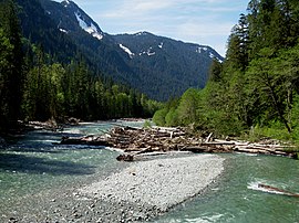
33:Baker River upstream of Baker Lake
16:River in Washington, United States
14:
707:. United States Geological Survey
445:Baker River Hydroelectric Project
294:297 sq mi (770 km)
471:. Upper Baker Dam is located in
386:. It drains an area of the high
62:
55:
45:Map of the Baker River watershed
39:
27:
877:Cauvel, Kimberly (2023-09-12).
679:United States Geological Survey
735:University of Washington Press
539:(Oncorhynchus clarki clarki).
527:(Oncorhynchus gorbuscha), and
235: • coordinates
154: • coordinates
1:
467:Most of Baker Lake is in the
434:, in the northern section of
121:Physical characteristics
1195:Rivers of Washington (state)
523:(Oncorhynchus tshawytscha),
436:North Cascades National Park
408:North Cascades National Park
274: • elevation
197:5,800 ft (1,800 m)
193: • elevation
75:of Baker River in Washington
312: • location
219: • location
141: • location
1226:
535:(Oncorhynchus mykiss) and
414:. The river flows through
348: • maximum
338: • minimum
328: • average
1164:
725:Bates, Dawn; Hess, Thom;
483:. Both dams are owned by
356:
298:
201:
125:
50:
38:
26:
519:(Oncorhynchus kisutch),
278:820 ft (250 m)
883:Northwest Treaty Tribes
537:sea-run cutthroat trout
499:Baker River at Concrete
371:
286:30 mi (48 km)
1127:Georgetown Steam Plant
731:Lushootseed Dictionary
605:Shuksan Lake Creek (R)
552:
500:
257:48.76500°N 121.54278°W
176:48.85028°N 121.38111°W
550:
498:
1122:Puget Power Building
416:Concrete, Washington
390:in the watershed of
262:48.76500; -121.54278
181:48.85028; -121.38111
253: /
172: /
1008:Puget Sound Energy
553:
501:
485:Puget Sound Energy
479:above the town of
420:Puget Sound Energy
1182:
1181:
1156:Energize Eastside
1151:Puget Power trail
1080:Lower Snake River
1055:Sulphur Creek Dam
744:978-0-295-97323-4
571:Sulphur Creek (R)
360:
359:
1217:
1169:Energy Northwest
1131:
1106:Nunnally Johnson
1062:Snoqualmie Falls
1058:
1037:
1001:
994:
987:
978:
971:
970:
968:
967:
961:
954:
946:
940:
939:
937:
936:
930:
923:
915:
909:
908:
899:
893:
892:
890:
889:
874:
868:
867:
865:
864:
853:
847:
846:
844:
843:
828:
819:
818:
816:
815:
809:
798:
790:
781:
780:
778:
777:
771:
763:
757:
756:
722:
716:
715:
713:
712:
706:
698:
687:
686:
665:
626:Picket Creek (L)
620:Bald Eagle Creek
447:
446:
378:in northwestern
349:
339:
329:
313:
268:
267:
265:
264:
263:
258:
254:
251:
250:
249:
246:
194:
187:
186:
184:
183:
182:
177:
173:
170:
169:
168:
165:
155:
142:
71:Location of the
66:
65:
59:
43:
31:
19:
1225:
1224:
1220:
1219:
1218:
1216:
1215:
1214:
1185:
1184:
1183:
1178:
1160:
1134:
1129:
1110:
1089:
1066:
1051:Rocky Creek Dam
1048:
1034:Upper Baker Dam
1030:Lower Baker Dam
1027:
1010:
1005:
975:
974:
965:
963:
959:
952:
948:
947:
943:
934:
932:
928:
921:
917:
916:
912:
901:
900:
896:
887:
885:
876:
875:
871:
862:
860:
855:
854:
850:
841:
839:
830:
829:
822:
813:
811:
807:
796:
792:
791:
784:
775:
773:
769:
765:
764:
760:
745:
724:
723:
719:
710:
708:
704:
700:
699:
690:
667:
666:
653:
648:
636:
577:Sandy Creek (R)
568:Rocky Creek (R)
545:
533:steelhead trout
493:
491:Natural history
462:Lower Baker Dam
460:, impounded by
454:Upper Baker Dam
452:, impounded by
444:
443:
428:
347:
337:
327:
311:
275:
261:
259:
255:
252:
247:
244:
242:
240:
239:
236:
220:
192:
180:
178:
174:
171:
166:
163:
161:
159:
158:
153:
140:
79:
78:
77:
76:
69:
68:
67:
46:
34:
17:
12:
11:
5:
1223:
1221:
1213:
1212:
1207:
1202:
1197:
1187:
1186:
1180:
1179:
1177:
1176:
1171:
1165:
1162:
1161:
1159:
1158:
1153:
1148:
1142:
1140:
1136:
1135:
1133:
1132:
1124:
1118:
1116:
1112:
1111:
1109:
1108:
1103:
1097:
1095:
1091:
1090:
1088:
1087:
1082:
1076:
1074:
1068:
1067:
1065:
1064:
1059:
1043:
1038:
1021:
1019:
1012:
1011:
1006:
1004:
1003:
996:
989:
981:
973:
972:
941:
910:
894:
869:
848:
838:on 28 May 2009
820:
810:on 9 June 2009
782:
758:
743:
737:. p. 85.
717:
688:
650:
649:
647:
644:
643:
642:
635:
632:
631:
630:
627:
624:
621:
618:
615:Sulphide Creek
612:
606:
603:
597:
596:
595:
593:Morovitz Creek
584:
578:
575:
574:Anderson Creek
572:
569:
566:
563:
544:
541:
505:Sockeye salmon
492:
489:
473:Whatcom County
427:
424:
398:, and east of
388:North Cascades
358:
357:
354:
353:
350:
344:
343:
340:
334:
333:
330:
324:
323:
314:
308:
307:
304:
300:
299:
296:
295:
292:
288:
287:
284:
280:
279:
276:
273:
270:
269:
237:
234:
231:
230:
221:
218:
215:
214:
209:
203:
202:
199:
198:
195:
189:
188:
156:
150:
149:
147:Whatcom County
145:Whatcom Peak,
143:
137:
136:
131:
127:
126:
123:
122:
118:
117:
108:
104:
103:
98:
94:
93:
90:
86:
85:
81:
80:
70:
61:
60:
54:
53:
52:
51:
48:
47:
44:
36:
35:
32:
24:
23:
15:
13:
10:
9:
6:
4:
3:
2:
1222:
1211:
1208:
1206:
1203:
1201:
1198:
1196:
1193:
1192:
1190:
1175:
1172:
1170:
1167:
1166:
1163:
1157:
1154:
1152:
1149:
1147:
1144:
1143:
1141:
1137:
1128:
1125:
1123:
1120:
1119:
1117:
1113:
1107:
1104:
1102:
1099:
1098:
1096:
1092:
1086:
1083:
1081:
1078:
1077:
1075:
1073:
1069:
1063:
1060:
1056:
1052:
1047:
1044:
1042:
1039:
1035:
1031:
1026:
1023:
1022:
1020:
1017:
1016:Hydroelectric
1013:
1009:
1002:
997:
995:
990:
988:
983:
982:
979:
962:on 2016-06-24
958:
951:
945:
942:
931:on 2016-12-20
927:
920:
914:
911:
906:
905:
898:
895:
884:
880:
873:
870:
858:
852:
849:
837:
833:
827:
825:
821:
806:
802:
795:
789:
787:
783:
768:
762:
759:
754:
750:
746:
740:
736:
732:
728:
721:
718:
703:
697:
695:
693:
689:
684:
680:
676:
675:
670:
669:"Baker River"
664:
662:
660:
658:
656:
652:
645:
641:
638:
637:
633:
629:Mineral Creek
628:
625:
622:
619:
616:
613:
610:
607:
604:
601:
600:Shannon Creek
598:
594:
591:
590:
588:
585:
582:
579:
576:
573:
570:
567:
564:
561:
560:Thunder Creek
558:
557:
556:
549:
542:
540:
538:
534:
530:
526:
522:
518:
513:
509:
506:
497:
490:
488:
486:
482:
478:
477:Skagit County
474:
470:
465:
463:
459:
455:
451:
441:
440:Mount Shuksan
437:
433:
425:
423:
421:
417:
413:
409:
405:
401:
397:
393:
389:
385:
384:United States
381:
377:
373:
369:
365:
355:
351:
345:
341:
335:
331:
325:
322:
318:
315:
309:
305:
301:
297:
293:
289:
285:
281:
277:
271:
266:
238:
232:
229:
228:Skagit County
225:
222:
216:
213:
210:
208:
204:
200:
196:
190:
185:
157:
151:
148:
144:
138:
135:
134:Cascade Range
132:
128:
124:
119:
116:
112:
109:
105:
102:
99:
95:
92:United States
91:
87:
82:
74:
58:
49:
42:
37:
30:
25:
20:
1046:Koma Kulshan
964:. Retrieved
957:the original
944:
933:. Retrieved
926:the original
913:
903:
897:
886:. Retrieved
882:
872:
861:. Retrieved
851:
840:. Retrieved
836:the original
812:. Retrieved
805:the original
800:
774:. Retrieved
761:
730:
720:
709:. Retrieved
672:
554:
514:
510:
502:
466:
458:Lake Shannon
432:Whatcom Peak
429:
376:Skagit River
363:
361:
321:Concrete, WA
212:Skagit River
1101:Jacob Furth
1025:Baker River
733:. Seattle:
727:Hilbert, Vi
587:Swift Creek
543:Tributaries
400:Mount Baker
392:Puget Sound
368:Lushootseed
364:Baker River
260: /
248:121°32′34″W
179: /
167:121°22′52″W
22:Baker River
1189:Categories
1085:Wild Horse
1072:Wind farms
966:2016-06-01
935:2016-06-01
888:2023-09-13
863:2016-06-01
842:2009-06-01
814:2009-06-01
776:2009-05-31
711:2009-05-31
646:References
623:Pass Creek
609:Blum Creek
581:Park Creek
565:Bear Creek
450:Baker Lake
412:Skagit Bay
380:Washington
317:river mile
291:Basin size
245:48°45′54″N
101:Washington
1115:Buildings
404:watershed
402:. With a
394:north of
319:0.7 near
303:Discharge
164:48°51′1″N
1041:Electron
1018:projects
753:29877333
729:(1994).
634:See also
481:Concrete
224:Concrete
84:Location
521:chinook
396:Seattle
382:in the
372:dxʷqəlb
115:Whatcom
89:Country
1094:People
751:
741:
426:Course
306:
283:Length
130:Source
111:Skagit
107:County
1139:Other
960:(PDF)
953:(PDF)
929:(PDF)
922:(PDF)
808:(PDF)
797:(PDF)
770:(PDF)
705:(PDF)
207:Mouth
97:State
73:mouth
749:OCLC
739:ISBN
589:(R)
529:chum
525:pink
517:coho
362:The
1053:) (
1032:) (
617:(R)
611:(L)
602:(R)
583:(R)
562:(L)
1191::
881:.
823:^
799:.
785:^
747:.
691:^
681:,
677:.
671:.
654:^
487:.
422:.
370::
226:,
113:,
1057:)
1049:(
1036:)
1028:(
1000:e
993:t
986:v
969:.
938:.
891:.
866:.
845:.
817:.
779:.
755:.
714:.
685:.
366:(
Text is available under the Creative Commons Attribution-ShareAlike License. Additional terms may apply.