1506:
179:
29:
166:
The name of the park is due to the former property owner, Ernest
Ballard. In 1939, he bought the land. By that time, the original mill was scrapped, and Ballard bought a similar mill, and subsequently spent two years together with his wife restoring the mill and replacing missing parts. In 1953, he
1484:
269:
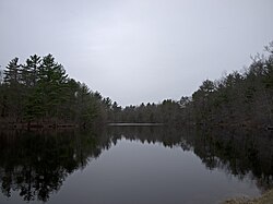
151:, an old sawmill, and Ballard Pond, which provides water for the mill. The forest is located on Island Pond Road, east of the downtown of Derry. The pond drains via Taylor Brook and
1571:
399:
1547:
262:
152:
513:
427:
203:
79:
593:
255:
703:
290:
1581:
723:
353:
307:
299:
1566:
419:
278:
1540:
788:
132:
46:
389:
450:
394:
1422:
931:
768:
578:
533:
404:
144:
61:
1086:
728:
493:
409:
317:
763:
1533:
916:
325:
1576:
856:
718:
573:
673:
488:
72:
1391:
996:
207:
1401:
1286:
871:
658:
603:
441:
1291:
1201:
1126:
1111:
1046:
966:
921:
886:
1461:
1281:
1246:
1026:
563:
478:
1331:
1241:
1161:
1116:
1466:
1356:
1271:
1261:
1036:
961:
668:
568:
523:
508:
463:
148:
1351:
1326:
1316:
1236:
1076:
1011:
981:
851:
1386:
1366:
1266:
1226:
1091:
1071:
971:
941:
831:
743:
678:
653:
618:
588:
518:
483:
381:
1296:
1251:
1221:
1191:
1171:
1156:
1081:
1066:
956:
1396:
1336:
1216:
1206:
1181:
1151:
1121:
1106:
951:
926:
866:
821:
1321:
1146:
1096:
891:
733:
698:
638:
613:
1311:
1306:
1231:
1166:
1136:
1101:
1456:
1406:
1371:
1276:
1256:
1186:
1061:
1021:
946:
906:
901:
896:
811:
683:
648:
548:
335:
1381:
1346:
1301:
936:
911:
861:
1361:
1341:
1211:
1056:
1051:
1041:
1031:
991:
976:
876:
841:
836:
773:
753:
713:
628:
583:
553:
473:
1376:
1196:
147:, in the southeast part of the state. The area of the park is 71 acres (0.29 km). It includes the
1131:
1006:
1001:
986:
1446:
1141:
758:
688:
643:
528:
184:
140:
56:
826:
796:
738:
608:
598:
538:
468:
1176:
806:
801:
778:
708:
503:
1016:
881:
816:
693:
633:
498:
343:
1517:
229:
1451:
458:
1505:
663:
623:
160:
1560:
1513:
543:
371:
361:
282:
156:
136:
65:
748:
366:
247:
558:
174:
94:
81:
28:
251:
167:
donated the mill and the land to the state of New
Hampshire.
1485:
New
Hampshire Department of Natural and Cultural Resources
1521:
206:. Parks & Recreation New Hampshire. Archived from
1435:
1415:
787:
449:
440:
418:
380:
352:
334:
316:
298:
289:
118:
110:
71:
52:
42:
21:
16:State forest in Rockingham County, New Hampshire
1541:
428:Great Bay National Estuarine Research Reserve
263:
8:
122:New Hampshire Division of Forests and Lands
1548:
1534:
1439:
446:
295:
270:
256:
248:
18:
1572:Parks in Rockingham County, New Hampshire
198:
196:
192:
7:
1502:
1500:
41:
1520:. You can help Knowledge (XXG) by
14:
300:National Historic Parks and Sites
204:"Taylor Mill State Historic Site"
1504:
579:Governor Wentworth Historic Site
177:
51:
27:
354:National wild and scenic rivers
117:
109:
1:
1582:New Hampshire geography stubs
1516:state location article is a
1567:New Hampshire state forests
1598:
1499:
1462:Proctor Wildlife Sanctuary
764:Wentworth–Coolidge Mansion
1479:
1467:Sheldrick Forest Preserve
1442:
1416:Wildlife management areas
569:Franklin Pierce Homestead
514:Daniel Webster Birthplace
382:National Wildlife Refuges
149:Taylor Mill Historic Site
38:
26:
574:Gardner Memorial Wayside
519:Deer Mountain Campground
114:71 acres (0.29 km)
1457:Lost River Reservation
594:Hannah Duston Memorial
1362:Urban Forestry Center
420:Other protected areas
159:, a tributary of the
1577:Derry, New Hampshire
1447:Chandler Reservation
1392:West Iron Works Road
997:Foster & Colburn
185:New Hampshire portal
129:Ballard State Forest
22:Ballard State Forest
1287:Second Presidential
932:Conway Common Lands
534:Eisenhower Memorial
95:42.8745°N 71.2392°W
91: /
1087:Kearsarge Mountain
494:Chesterfield Gorge
479:Beaver Brook Falls
232:. Londonderry News
1529:
1528:
1494:
1493:
1475:
1474:
1431:
1430:
1292:Sentinel Mountain
1127:Lovewell Mountain
1112:Little Pine River
1047:Harriman-Chandler
922:Connecticut River
917:Connecticut Lakes
882:Blue Job Mountain
674:Northwood Meadows
554:Fort Constitution
436:
435:
344:Appalachian Trail
308:Saint-Gaudens NHP
230:"Taylor Saw Mill"
145:Rockingham County
126:
125:
100:42.8745; -71.2392
62:Rockingham County
1589:
1550:
1543:
1536:
1508:
1501:
1452:Kauffmann Forest
1440:
1282:Scribner-Fellows
1027:Goodwin-Chandler
887:Bowditch-Runnels
857:Belknap Mountain
719:Sculptured Rocks
604:Jericho Mountain
447:
318:National Forests
296:
272:
265:
258:
249:
242:
241:
239:
237:
226:
220:
219:
217:
215:
200:
187:
182:
181:
180:
119:Operated by
106:
105:
103:
102:
101:
96:
92:
89:
88:
87:
84:
31:
19:
1597:
1596:
1592:
1591:
1590:
1588:
1587:
1586:
1557:
1556:
1555:
1554:
1497:
1495:
1490:
1471:
1427:
1411:
1332:Strawberry Hill
1242:Ragged Mountain
1162:Merrimack River
1117:Livermore Falls
783:
664:Nansen Ski Jump
624:Madison Boulder
564:Franconia Notch
432:
414:
400:Silvio O. Conte
376:
348:
336:National Trails
330:
312:
285:
279:Protected areas
276:
246:
245:
235:
233:
228:
227:
223:
213:
211:
202:
201:
194:
183:
178:
176:
173:
161:Merrimack River
99:
97:
93:
90:
85:
82:
80:
78:
77:
60:
34:
17:
12:
11:
5:
1595:
1593:
1585:
1584:
1579:
1574:
1569:
1559:
1558:
1553:
1552:
1545:
1538:
1530:
1527:
1526:
1509:
1492:
1491:
1489:
1488:
1480:
1477:
1476:
1473:
1472:
1470:
1469:
1464:
1459:
1454:
1449:
1443:
1437:
1433:
1432:
1429:
1428:
1426:
1425:
1419:
1417:
1413:
1412:
1410:
1409:
1404:
1402:William Thomas
1399:
1394:
1389:
1384:
1379:
1374:
1369:
1364:
1359:
1354:
1349:
1344:
1339:
1334:
1329:
1324:
1319:
1314:
1309:
1304:
1299:
1294:
1289:
1284:
1279:
1274:
1272:Saltmarsh Pond
1269:
1264:
1262:Russell-Abbott
1259:
1254:
1249:
1244:
1239:
1234:
1229:
1224:
1219:
1214:
1209:
1204:
1199:
1194:
1189:
1184:
1179:
1174:
1169:
1164:
1159:
1154:
1149:
1144:
1139:
1134:
1129:
1124:
1119:
1114:
1109:
1104:
1099:
1094:
1089:
1084:
1079:
1074:
1069:
1064:
1059:
1054:
1049:
1044:
1039:
1037:Green Mountain
1034:
1029:
1024:
1019:
1014:
1009:
1004:
999:
994:
989:
984:
979:
974:
969:
964:
959:
954:
949:
944:
939:
934:
929:
924:
919:
914:
909:
904:
899:
894:
889:
884:
879:
874:
872:Black Mountain
869:
864:
859:
854:
849:
844:
839:
834:
829:
824:
819:
814:
809:
804:
799:
793:
791:
785:
784:
782:
781:
776:
771:
766:
761:
756:
751:
746:
741:
736:
731:
726:
721:
716:
711:
706:
701:
696:
691:
686:
681:
676:
671:
666:
661:
659:Mt. Washington
656:
651:
646:
641:
636:
631:
626:
621:
616:
611:
606:
601:
596:
591:
586:
581:
576:
571:
566:
561:
556:
551:
546:
541:
536:
531:
526:
524:Dixville Notch
521:
516:
511:
509:Crawford Notch
506:
501:
496:
491:
486:
481:
476:
471:
466:
461:
455:
453:
444:
438:
437:
434:
433:
431:
430:
424:
422:
416:
415:
413:
412:
407:
402:
397:
392:
386:
384:
378:
377:
375:
374:
369:
364:
358:
356:
350:
349:
347:
346:
340:
338:
332:
331:
329:
328:
326:White Mountain
322:
320:
314:
313:
311:
310:
304:
302:
293:
287:
286:
277:
275:
274:
267:
260:
252:
244:
243:
221:
210:on 11 May 2012
191:
190:
189:
188:
172:
169:
124:
123:
120:
116:
115:
112:
108:
107:
75:
69:
68:
54:
50:
49:
44:
40:
39:
36:
35:
32:
24:
23:
15:
13:
10:
9:
6:
4:
3:
2:
1594:
1583:
1580:
1578:
1575:
1573:
1570:
1568:
1565:
1564:
1562:
1551:
1546:
1544:
1539:
1537:
1532:
1531:
1525:
1523:
1519:
1515:
1514:New Hampshire
1510:
1507:
1503:
1498:
1487:
1486:
1482:
1481:
1478:
1468:
1465:
1463:
1460:
1458:
1455:
1453:
1450:
1448:
1445:
1444:
1441:
1438:
1434:
1424:
1421:
1420:
1418:
1414:
1408:
1405:
1403:
1400:
1398:
1395:
1393:
1390:
1388:
1385:
1383:
1380:
1378:
1375:
1373:
1370:
1368:
1365:
1363:
1360:
1358:
1355:
1353:
1352:Totten Trails
1350:
1348:
1345:
1343:
1340:
1338:
1335:
1333:
1330:
1328:
1327:Stevens Pines
1325:
1323:
1320:
1318:
1317:Soucook River
1315:
1313:
1310:
1308:
1305:
1303:
1300:
1298:
1295:
1293:
1290:
1288:
1285:
1283:
1280:
1278:
1275:
1273:
1270:
1268:
1265:
1263:
1260:
1258:
1255:
1253:
1250:
1248:
1245:
1243:
1240:
1238:
1237:Province Road
1235:
1233:
1230:
1228:
1225:
1223:
1220:
1218:
1215:
1213:
1210:
1208:
1205:
1203:
1202:Page's Corner
1200:
1198:
1195:
1193:
1190:
1188:
1185:
1183:
1180:
1178:
1175:
1173:
1170:
1168:
1165:
1163:
1160:
1158:
1155:
1153:
1150:
1148:
1145:
1143:
1140:
1138:
1135:
1133:
1130:
1128:
1125:
1123:
1120:
1118:
1115:
1113:
1110:
1108:
1105:
1103:
1100:
1098:
1095:
1093:
1090:
1088:
1085:
1083:
1080:
1078:
1077:Huston-Morgan
1075:
1073:
1070:
1068:
1065:
1063:
1060:
1058:
1055:
1053:
1050:
1048:
1045:
1043:
1040:
1038:
1035:
1033:
1030:
1028:
1025:
1023:
1020:
1018:
1015:
1013:
1012:George Duncan
1010:
1008:
1005:
1003:
1000:
998:
995:
993:
990:
988:
985:
983:
982:Fall Mountain
980:
978:
975:
973:
970:
968:
965:
963:
960:
958:
955:
953:
950:
948:
945:
943:
940:
938:
935:
933:
930:
928:
925:
923:
920:
918:
915:
913:
910:
908:
905:
903:
900:
898:
895:
893:
890:
888:
885:
883:
880:
878:
875:
873:
870:
868:
865:
863:
860:
858:
855:
853:
852:Bear Mountain
850:
848:
845:
843:
840:
838:
835:
833:
830:
828:
825:
823:
820:
818:
815:
813:
810:
808:
805:
803:
800:
798:
795:
794:
792:
790:
789:State forests
786:
780:
777:
775:
772:
770:
767:
765:
762:
760:
757:
755:
752:
750:
747:
745:
742:
740:
737:
735:
732:
730:
727:
725:
722:
720:
717:
715:
712:
710:
707:
705:
702:
700:
697:
695:
692:
690:
687:
685:
682:
680:
679:Odiorne Point
677:
675:
672:
670:
669:North Hampton
667:
665:
662:
660:
657:
655:
652:
650:
647:
645:
642:
640:
637:
635:
632:
630:
627:
625:
622:
620:
619:Lake Tarleton
617:
615:
612:
610:
607:
605:
602:
600:
597:
595:
592:
590:
589:Hampton Beach
587:
585:
582:
580:
577:
575:
572:
570:
567:
565:
562:
560:
557:
555:
552:
550:
547:
545:
544:Endicott Rock
542:
540:
537:
535:
532:
530:
527:
525:
522:
520:
517:
515:
512:
510:
507:
505:
502:
500:
497:
495:
492:
490:
487:
485:
484:Bedell Bridge
482:
480:
477:
475:
472:
470:
467:
465:
462:
460:
457:
456:
454:
452:
448:
445:
443:
439:
429:
426:
425:
423:
421:
417:
411:
408:
406:
403:
401:
398:
396:
393:
391:
388:
387:
385:
383:
379:
373:
372:Wildcat Brook
370:
368:
365:
363:
362:Lamprey River
360:
359:
357:
355:
351:
345:
342:
341:
339:
337:
333:
327:
324:
323:
321:
319:
315:
309:
306:
305:
303:
301:
297:
294:
292:
288:
284:
283:New Hampshire
280:
273:
268:
266:
261:
259:
254:
253:
250:
231:
225:
222:
209:
205:
199:
197:
193:
186:
175:
170:
168:
164:
162:
158:
157:Spicket River
154:
150:
146:
142:
138:
137:New Hampshire
134:
130:
121:
113:
104:
76:
74:
70:
67:
66:New Hampshire
63:
58:
55:
48:
45:
37:
30:
25:
20:
1522:expanding it
1511:
1496:
1483:
1387:Welton Falls
1367:Vienna Smith
1357:Upton-Morgan
1267:Russell-Shea
1247:Reed's Ferry
1227:Powwow River
1092:Lang Station
1072:Hubbard Hill
962:Devils Slide
846:
832:Annie Duncan
769:White Island
744:Wallis Sands
734:Umbagog Lake
704:Robert Frost
699:Rhododendron
639:Mollidgewock
614:Lake Francis
464:Androscoggin
367:Nashua River
234:. Retrieved
224:
212:. Retrieved
208:the original
165:
133:state forest
128:
127:
47:State forest
33:Ballard Pond
1297:Shadow Hill
1252:Rock Rimmon
1222:Piscataquog
1192:Opechee Bay
1177:Nash Stream
1157:Meadow Pond
1082:Hyland Hill
1067:Honey Brook
972:Dodge Brook
967:District #5
957:Davis-White
942:Craney Hill
729:Taylor Mill
724:Silver Lake
684:Pawtuckaway
654:Mt. Sunapee
649:Moose Brook
549:Forest Lake
451:State parks
153:Island Pond
139:located in
98: /
73:Coordinates
1561:Categories
1397:White Farm
1337:Sugar Hill
1217:Pine River
1207:Paugus Bay
1182:Nottingham
1152:Max Israel
1122:Lord Pines
1107:Litchfield
952:Davisville
927:Contoocook
867:Big Island
822:Ammonoosuc
774:White Lake
754:Wellington
714:Rye Harbor
629:Milan Hill
584:Greenfield
559:Fort Stark
474:Bear Brook
171:References
86:71°14′21″W
83:42°52′28″N
1322:Southeast
1172:Mt. Major
1147:Mast Yard
1097:Lead Mine
892:Cape Horn
812:Alton Bay
759:Wentworth
689:Pillsbury
644:Monadnock
529:Echo Lake
390:Great Bay
155:into the
1312:Sky Pond
1307:Shieling
1232:Prescott
1167:Merriman
1137:Marshall
1102:Leighton
1057:Hemenway
837:Ashenden
739:Wadleigh
609:Kingston
539:Ellacoya
489:Cardigan
395:John Hay
236:29 April
214:29 April
53:Location
1423:Cornish
1407:Woodman
1372:Vincent
1277:Sanborn
1257:Russell
1187:Nursery
1142:Mascoma
1062:Hodgman
1022:Gilmore
947:Cushman
907:Chemung
902:Casalis
897:Carroll
847:Ballard
779:Winslow
709:Rollins
599:Jenness
504:Coleman
405:Umbagog
291:Federal
1382:Walker
1347:Taylor
1302:Shaker
937:Cowden
912:Cilley
862:Benton
827:Annett
797:Abbott
694:Pisgah
634:Miller
499:Clough
469:Annett
410:Wapack
1512:This
1436:Other
1342:Swain
1212:Percy
1052:Haven
1042:Hamel
1032:Grant
992:Feuer
977:Eaton
877:Blair
842:Ayers
807:Allen
802:Agnew
749:Weeks
459:Ahern
442:State
141:Derry
131:is a
57:Derry
1518:stub
1377:Wade
1197:Page
1017:Gile
817:Ames
238:2012
216:2012
111:Area
43:Type
1132:Low
1007:Gay
1002:Fox
987:Fay
281:of
135:of
1563::
195:^
163:.
143:,
64:,
1549:e
1542:t
1535:v
1524:.
271:e
264:t
257:v
240:.
218:.
59:,
Text is available under the Creative Commons Attribution-ShareAlike License. Additional terms may apply.