31:
1585:
1573:
430:(MCC), an idea that was first developed based on studies in this province. A metamorphic core complex occurs when lower crust is brought to the surface as a result of extension. MCCs in the Basin and Range were not interpreted as being related to crustal extension until after the 1960s. Since then, similar deformational patterns have been identified in MCCs in the Basin and Range and has led geologists to examine them as a group of related geologic features formed by crustal extension during the
1561:
137:
1537:
1515:
317:
297:. The base of the lithosphere beneath the Basin and Range is estimated to be about 60–70 km. Opinions vary regarding the total extension of the region; however, the median estimate is about 100% total lateral extension. Total lateral displacement in the Basin and Range varies from 60 to 300 km since the onset of extension in the Early
1549:
414:. Geologic processes that elevate heat flow are varied, however some researchers suggest that heat generated at a subduction zone is transferred to the overriding plate as subduction proceeds. Fluids along fault zones then transfer heat vertically through the crust. This model has led to increasing interest in
326:
The tectonic mechanisms responsible for lithospheric extension in the Basin and Range province are controversial, and several competing hypotheses attempt to explain them. Key events preceding Basin and Range extension in the western United States include a long period of compression due to the
405:
as a consequence. Lithospheric regions characterized by elevated heat flow are weak and extensional deformation can occur over a broad region. Basin and Range extension is therefore thought to be unrelated to the kind of extension produced by
393:
caused spontaneous extensional faulting similar to that seen in the Great Basin. However, plate movement alone does not account for the high elevation of the Basin and Range region. The western United States is a region of high
301:
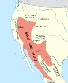
with the southern portion of the province representing a greater degree of displacement than the north. Evidence exists to suggest that extension initially began in the southern Basin and Range and propagated north over time.
443:
939:(1987). "Landslide and debris-flow deposits in the Thumb Member of the Miocene Horse Spring Formation on the east side of Frenchman Mountain, Nevada: A measure of basin-range extension". In Hill, Mason L (ed.).
458:
Prior to the Eocene Epoch (55.8 ±0.2 to 33.9 ±0.1 Ma) the convergence rate of the
Farallon and North American Plates was fast, the angle of subduction was shallow, and the slab width was huge. During the
751:
752:"USGS National Elevation Dataset (NED) 1 meter Downloadable Data Collection from The National Map 3D Elevation Program (3DEP) – National Geospatial Data Asset (NGDA) National Elevation Data Set (NED)"
335:
under the west coast of the North
American continental plate which stimulated the thickening of the crust. Most of the pertinent tectonic plate movement associated with the province occurred in the
385:
The tectonic activity responsible for the extension in the Basin and Range is a complex and controversial issue among the geoscience community. The most accepted hypothesis suggests that crustal
879:
Zandt, G; Myers, S; Wallace, T (1995). "Crust and mantle structure across the Basin and Range-Colorado
Plateau boundary at 37°N latitude and implications for Cenozoic extensional mechanism".
124:, a region defined by its unique hydrological characteristics (internal drainage) that overlaps much of the greater Basin and Range physiographic region. Nor should it be confused with the
418:
in the Basin and Range, and requires consideration of the continued influence of the fully subducted
Farallon plate in the extension responsible for the Basin and Range Province.
434:
era (66.0 million years ago to present). The study of metamorphic core complexes has provided valuable insight into the extensional processes driving Basin and Range formation.
2128:
308:
famously compared the many narrow parallel mountain ranges that distinguish the unique topography of the Basin and Range to an "army of caterpillars crawling northward."
2113:
490:). It is suggested that this plate continued to be underthrust until about 19 Ma, at which time it was completely consumed and volcanic activity ceased, in part.
218:
valleys alternating with mountains (as described below). The area is mostly arid and sparsely populated, although there are several major metropolitan areas, such as
1617:
759:
2193:
732:
2138:
180:, though the southern boundaries of the Basin and Range are debated. In Mexico, the Basin and Range Province is dominated by and largely synonymous with the
73:
The numerous ranges within the province in the United States are collectively referred to as the "Great Basin Ranges", although many are not actually in the
1925:
1165:
449:
378:
component. Today, the
Pacific Plate moves north-westward relative to North America, a configuration which has given rise to increased shearing along the
2049:
2123:
1121:
Yamano, Makoto; Kinoshita, Masataka; Goto, Shusaku (2008). "High heat flow anomalies on an old oceanic plate observed seaward of the Japan Trench".
2148:
1247:
1683:
2173:
1272:
1027:
2133:
1610:
1076:
58:, characterized by abrupt changes in elevation, alternating between narrow faulted mountain chains and flat arid valleys or basins. The
914:
2009:
1410:
1386:
1361:
1340:
1310:
722:
43:
1519:
2103:
1707:
125:
1191:
McKee, E. H. (1971). "Tertiary
Igneous Chronology of the Great Basin of Western United States – Implications for Tectonic Models".
2108:
1884:
864:
Mooney, Walter D; Braile, Lawrence W (1989). "The seismic structure of the continental crust and upper mantle of North
America".
487:
997:
2060:
755:
1999:
2163:
1994:
1603:
1793:
289:
The average crustal thickness of the Basin and Range
Province is approximately 30–35 km and is comparable to extended
30:
2188:
1735:
1671:
557:
1527:
1227:"Northwest Origins, An Introduction to the Geologic History of Washington State, Catherine L. Townsend and John T. Figge"
2183:
2055:
821:
610:
86:
1848:
2168:
2143:
1765:
1659:
620:
528:
173:
2178:
2118:
1971:
1755:
1302:
55:
781:
Henry, C; Aranda-Gomez, J (1992). "The real southern Basin and Range: Mid- to late
Cenozoic extension in Mexico".
2158:
1915:
625:
605:
802:
533:
2153:
1665:
1212:
1169:
697:
689:
546:
427:
344:
1424:(16 July 2010). "Cenozoic Tectonics of Western North America Controlled by Evolving Width of Farallon Slab".
426:
In some localities in the Basin and Range, metamorphic basement is visible at the surface. Some of these are
1961:
1843:
1730:
712:
701:
615:
204:
1863:
643:
577:
352:
187:
Evidence suggests that the less-recognized southern portion of the province is bounded on the east by the
114:
1989:
2065:
2044:
2019:
1745:
717:
693:
262:
It is generally accepted that basin and range topography is the result of extension and thinning of the
192:
63:
47:
581:
359:(15.97-11.63 million years ago), the Pacific-Farallon Ridge was subducted beneath North America ending
1251:
968:
Sixth Annual Report of the United States
Geological Survey to the Secretary of the Interior, 1884-1885
2003:
1589:
1485:
1469:
1433:
1200:
1130:
888:
830:
816:
790:
591:
563:
411:
286:
geometry, where horst refers to the upthrown fault block and graben to the down dropped fault block.
271:
153:
1940:
573:
568:
1966:
1867:
1788:
1595:
932:
499:
453:
415:
94:
2082:
2077:
1853:
1838:
1798:
1760:
1689:
1457:
1226:
1146:
846:
379:
363:
along this part of the Pacific margin; however, the Farallon Plate continued to subduct into the
343:
sub-epoch (23.03-15.97 million years ago), much of the Farallon Plate had been consumed, and the
196:
59:
1332:
Geology of the American Southwest: A Journey Through Two Billion Years of Plate Tectonic History
1276:
1035:
1858:
1740:
1701:
1449:
1406:
1382:
1357:
1336:
1306:
407:
390:
368:
364:
290:
1378:
1372:
1084:
918:
1577:
1553:
1493:
1441:
1208:
1138:
971:
944:
936:
896:
838:
798:
471:
402:
267:
243:
231:
211:
188:
169:
161:
90:
1828:
1750:
1695:
1647:
1630:
648:
630:
599:
585:
483:
386:
371:
305:
279:
235:
181:
165:
51:
1489:
1437:
1204:
1134:
892:
834:
794:
278:, or faults that level out with depth. Opposing normal faults link at depth producing a
17:
1956:
1920:
1565:
1541:
524:
518:
491:
479:
475:
464:
332:
227:
200:
102:
82:
2097:
2071:
2039:
1899:
1833:
1802:
1713:
1150:
1005:
495:
395:
348:
275:
157:
145:
1461:
963:
850:
136:
2014:
1935:
1806:
1677:
1560:
1421:
367:. The movement at this boundary divided the Pacific-Farallon Ridge and spawned the
219:
128:, located in Southern Nevada, which is one small part of the much larger province.
106:
1400:
1351:
1330:
339:
period (23.03-2.58 million years ago) and continues to the present. By the Early
1930:
1894:
1812:
1396:
637:
512:
375:
320:
294:
263:
149:
140:
NASA satellite photo of typical Basin and Range topography across central Nevada
121:
78:
74:
293:
around the world. The crust in conjunction with the upper mantle comprises the
1889:
1627:
1142:
467:
360:
328:
251:
110:
98:
948:
842:
1445:
666:
223:
1453:
1229:. The Burke Museum of Natural History and Culture, University of Washington
482:
orogenies ended, plate interactions changed from orthogonal compression to
156:
and spans over 500 miles (800 km) to its eastern border marked by the
1514:
819:(2002). "The Basin and Range Province as a Composite Extensional Domain".
274:. Extensional environments like the Basin and Range are characterized by
943:. Vol. 1. Cordilleran Section of the Geological Society of America.
431:
399:
247:
109:
at −282 feet (−86 m). The province's climate is arid, with numerous
1498:
1473:
444:
List of large volume volcanic eruptions in the Basin and Range Province
356:
340:
336:
316:
298:
239:
67:
27:
Physiographic region extending through western United States and Mexico
900:
1250:. Oregon Department of Geology and Mineral Industries. Archived from
682:
678:
670:
663:
537:
460:
283:
215:
177:
915:"Geologic Provinces of the United States: Basin and Range Province"
1075:
Cengage, Gale (2003). Lerner, Lee; Lerner, Brenda Wilmoth (eds.).
315:
148:. In the United States, it is bordered on the west by the eastern
135:
29:
976:
727:
674:
550:
541:
1599:
1420:
Schellart, W.P.; Stegman, D.R.; Farrington, R.J.; Freeman, J.;
120:
The Basin and Range Province should not be confused with the
207:
in the center of the southernmost Basin and Range Province.
1110:(Class Notes), Dallas, Texas: University of Texas at Dallas
803:
10.1130/0091-7613(1992)020<0701:TRSBAR>2.3.CO;2
486:, and volcanism in the Basin and Range Province flared up (
398:
which lowers the density of the lithosphere and stimulates
1213:
10.1130/0016-7606(1971)82[3497:ticotg]2.0.co;2
410:
which may cause narrow rift zones, such as those of the
669:, the Basin and Range Province supplies nearly all the
34:
One of various geographical definitions of the Province
1273:"Digital Geology of Idaho, Laura DeGrey and Paul Link"
144:
The Basin and Range Province includes much of western
1525:
66:
that began around 17 million years ago in the early
2032:
1980:
1949:
1908:
1877:
1821:
1781:
1774:
1723:
1638:
1004:. San Diego Natural History Museum. Archived from
1377:(Eighth ed.). Boston: McGraw-Hill. pp.
93:. The highest point fully within the province is
718:Intermontane Plateaus § Basin and Range Province
1028:"Basin and Range Province – Tertiary Extension"
1611:
733:Northern Snake Range metamorphic core complex
8:
868:. Geological Society of America. p. 42.
210:Common geographic features include numerous
723:List of United States physiographic regions
347:that separated the Farallon Plate from the
203:with notably less faulting apparent in the
2129:Physiographic regions of the United States
1778:
1618:
1604:
1596:
1474:"Geotectonic Evolution of the Great Basin"
1055:
1053:
866:The Geology of North America – An Overview
450:Geologic timeline of Western North America
355:) approached North America. In the Middle
1497:
975:
2000:Middleton Place–Summerville Seismic Zone
1405:. New York: Farrar Straus & Giroux.
1297:Wood, Charles A.; Jűrgen Kienle (1993).
1275:. Idaho State University. Archived from
1108:Physics and Chemistry of the Solid Earth
2114:Geologic provinces of the United States
1532:
1123:International Journal of Earth Sciences
1106:Stern, Robert J (2010-09-01), "Rifts",
991:
989:
987:
743:
1926:Long Point–Eureka Heights fault system
1684:Northern Cordilleran Volcanic Province
1193:Geological Society of America Bulletin
470:-associated compressive forces of the
2050:Enriquillo–Plantain Garden fault zone
168:. The province extends north to the
7:
2194:Regions of the Western United States
758:. September 21, 2015. Archived from
2139:Seismic faults of the United States
1329:Baldridge, W. Scott (13 May 2004).
970:. U.S. Geological Survey: 113–198.
964:"Mount Taylor and the Zuni Plateau"
2010:Northern Appalachians Seismic Zone
1371:Plummer; McGeary; Carlson (1999).
519:Southwestern Nevada volcanic field
25:
1708:Southern Great Lakes Seismic Zone
214:, ephemeral lakes, plateaus, and
126:Basin and Range National Monument
62:of the province is the result of
1885:Independence Valley fault system
1583:
1571:
1559:
1547:
1535:
1513:
662:In addition to small amounts of
488:Mid-Tertiary ignimbrite flare-up
101:, while the lowest point is the
2124:Physiographic regions of Mexico
2061:Lesser Antilles subduction zone
756:United States Geological Survey
2149:Geography of Chihuahua (state)
1995:Eastern Tennessee Seismic Zone
1356:. University of Nevada Press.
1335:. Cambridge University Press.
498:erupted around 17 Ma and
1:
1736:Laurentian Slope Seismic Zone
1672:Clarendon-Linden fault system
558:Mogollon-Datil volcanic field
2056:Gulf of California Rift Zone
1248:"Oregon: A Geologic History"
1166:"Metamorphic Core Complexes"
1083:. eNotes.com. Archived from
1077:"Basin and Range Topography"
822:International Geology Review
685:mined in the United States.
611:Springerville volcanic field
46:covering much of the inland
2174:Geologic provinces of Texas
1916:Central Oklahoma Fault Zone
1766:Western Quebec Seismic Zone
1660:Canadian Arctic Rift System
626:Mount Taylor volcanic field
621:Zuni-Bandera volcanic field
529:Lunar Crater volcanic field
174:Trans-Mexican Volcanic Belt
77:. Major ranges include the
2210:
2134:Cenozoic rifts and grabens
1972:Wabash Valley Seismic Zone
1756:Saint Lawrence rift system
1641:(crosses national borders)
1353:Geology of the Great Basin
1303:Cambridge University Press
1299:Volcanoes of North America
687:
638:Trans-Pecos volcanic field
534:Indian Peak volcanic field
447:
441:
428:metamorphic core complexes
422:Metamorphic core complexes
56:basin and range topography
54:. It is defined by unique
1794:Olympic–Wallowa Lineament
1143:10.1007/s00531-007-0280-1
962:Dutton, Clarence (1885).
606:San Carlos volcanic field
2104:Basin and Range Province
1666:Cascadia subduction zone
1654:Basin and Range Province
1520:Basin and Range Province
1032:Digital Geology of Idaho
949:10.1130/0-8137-5401-1.49
843:10.2747/0020-6814.44.1.1
698:Silver mining in Arizona
690:Copper mining in Arizona
547:Marysvale volcanic field
374:, generating an oblique
345:seafloor spreading ridge
172:and south as far as the
40:Basin and Range Province
18:Basin and Range province
2109:Physiographic provinces
1962:New Madrid Seismic Zone
1849:Newport–Inglewood Fault
1844:Mendocino Fracture Zone
1731:Charlevoix Seismic Zone
1446:10.1126/science.1190366
1002:Ocean Oasis Field Guide
713:Cascade-Sierra province
702:Silver mining in Nevada
616:Red Hill volcanic field
276:listric normal faulting
266:, which is composed of
205:Sierra Madre Occidental
195:and on the west by the
117:are located within it.
1864:San Jacinto Fault Zone
1081:World of Earth Science
941:Centennial Field Guide
917:. USGS. Archived from
644:Big Bend National Park
353:Pacific-Farallon Ridge
323:
141:
115:North American deserts
35:
2164:Geology of New Mexico
2066:Middle America Trench
2045:Chixoy-Polochic Fault
2020:Virginia Seismic Zone
1981:Appalachian Mountains
1782:Washington and Oregon
1746:Queen Charlotte Fault
1470:Dickinson, William R.
817:Dickinson, William R.
694:Gold mining in Nevada
319:
193:Sierra Madre Oriental
139:
48:Western United States
33:
2189:Geography of Wyoming
2033:Caribbean and Mexico
1522:at Wikimedia Commons
1350:Fiero, Bill (2009).
1164:Rystrom, VL (2000).
1064:. New York: Freeman.
1062:Earth system history
1060:Stanley, SM (2005).
1038:on 11 September 2019
996:Riney, Brad (2000).
631:Jemez volcanic field
412:Afar Triple Junction
389:associated with the
191:Thrust Front of the
44:physiographic region
2184:Geography of Sonora
1990:Aiken–Augusta Fault
1967:Sandwich Fault Zone
1868:Elsinore Fault Zone
1789:Brothers Fault Zone
1490:2006Geosp...2..353D
1438:2010Sci...329..316S
1305:. pp. 284–86.
1205:1971GSAB...82.3497M
1135:2008IJEaS..97..345Y
937:Shoemaker, Eugene M
933:Salyards, Stephen L
893:1995JGR...10010529Z
887:(B6): 10529–10548.
835:2002IGRv...44....1D
795:1992Geo....20..701H
484:oblique strike-slip
454:Yellowstone hotspot
95:White Mountain Peak
52:northwestern Mexico
2169:Geology of Arizona
2144:Structural geology
2083:Puerto Rico Trench
2078:Pedro Miguel Fault
1983:and Atlantic Coast
1854:Puente Hills Fault
1839:Hayward Fault Zone
1761:Timiskaming Graben
1690:Puget Sound faults
1628:seismically active
1499:10.1130/GES00054.1
582:Doña Ana Mountains
416:geothermal systems
380:continental margin
324:
197:Gulf of California
142:
64:tectonic extension
36:
2179:Geology of Oregon
2119:Geology of Mexico
2091:
2090:
2074:(Central America)
2068:(Central America)
2028:
2027:
1936:Nemaha Fault Zone
1859:Rose Canyon Fault
1741:Leech River Fault
1702:San Andreas Fault
1518:Media related to
1472:(December 2006).
1199:(12): 3497–3502.
998:"Plate Tectonics"
901:10.1029/94JB03063
762:on March 25, 2019
658:Mineral resources
391:San Andreas Fault
291:continental crust
16:(Redirected from
2201:
2159:Geology of Idaho
1779:
1633:of North America
1620:
1613:
1606:
1597:
1588:
1587:
1586:
1576:
1575:
1574:
1564:
1563:
1552:
1551:
1550:
1540:
1539:
1538:
1531:
1517:
1503:
1501:
1465:
1432:(5989): 316–19.
1416:
1392:
1374:Physical Geology
1367:
1346:
1317:
1316:
1294:
1288:
1287:
1285:
1284:
1269:
1263:
1262:
1260:
1259:
1244:
1238:
1237:
1235:
1234:
1223:
1217:
1216:
1188:
1182:
1181:
1179:
1177:
1168:. Archived from
1161:
1155:
1154:
1118:
1112:
1111:
1103:
1097:
1096:
1094:
1092:
1072:
1066:
1065:
1057:
1048:
1047:
1045:
1043:
1034:. Archived from
1024:
1018:
1017:
1015:
1013:
993:
982:
981:
979:
959:
953:
952:
929:
923:
922:
911:
905:
904:
876:
870:
869:
861:
855:
854:
813:
807:
806:
778:
772:
771:
769:
767:
748:
673:and most of the
592:Socorro calderas
408:mantle upwelling
212:endorheic basins
170:Columbia Plateau
162:Colorado Plateau
91:Sandia Mountains
21:
2209:
2208:
2204:
2203:
2202:
2200:
2199:
2198:
2154:Geology of Utah
2094:
2093:
2092:
2087:
2024:
2004:Woodstock Fault
1982:
1976:
1945:
1904:
1873:
1829:Calaveras Fault
1817:
1770:
1751:Saguenay Graben
1719:
1696:Rio Grande rift
1648:Aleutian Trench
1640:
1634:
1624:
1594:
1584:
1582:
1572:
1570:
1558:
1548:
1546:
1536:
1534:
1526:
1510:
1468:
1419:
1413:
1402:Basin and Range
1395:
1389:
1370:
1364:
1349:
1343:
1328:
1325:
1323:Further reading
1320:
1313:
1296:
1295:
1291:
1282:
1280:
1271:
1270:
1266:
1257:
1255:
1246:
1245:
1241:
1232:
1230:
1225:
1224:
1220:
1190:
1189:
1185:
1175:
1173:
1163:
1162:
1158:
1120:
1119:
1115:
1105:
1104:
1100:
1090:
1088:
1074:
1073:
1069:
1059:
1058:
1051:
1041:
1039:
1026:
1025:
1021:
1011:
1009:
995:
994:
985:
961:
960:
956:
931:
930:
926:
913:
912:
908:
881:J. Geophys. Res
878:
877:
873:
863:
862:
858:
815:
814:
810:
789:(8): 20701–04.
780:
779:
775:
765:
763:
750:
749:
745:
741:
709:
704:
660:
655:
649:Davis Mountains
600:Jemez Lineament
586:Organ Mountains
508:
456:
446:
440:
424:
372:transform fault
314:
306:Clarence Dutton
260:
182:Mexican Plateau
166:Rio Grande Rift
134:
87:White Mountains
28:
23:
22:
15:
12:
11:
5:
2207:
2205:
2197:
2196:
2191:
2186:
2181:
2176:
2171:
2166:
2161:
2156:
2151:
2146:
2141:
2136:
2131:
2126:
2121:
2116:
2111:
2106:
2096:
2095:
2089:
2088:
2086:
2085:
2080:
2075:
2069:
2063:
2058:
2053:
2047:
2042:
2036:
2034:
2030:
2029:
2026:
2025:
2023:
2022:
2017:
2012:
2007:
1997:
1992:
1986:
1984:
1978:
1977:
1975:
1974:
1969:
1964:
1959:
1957:Marianna Fault
1953:
1951:
1947:
1946:
1944:
1943:
1941:Wilzetta Fault
1938:
1933:
1928:
1923:
1921:Humboldt Fault
1918:
1912:
1910:
1906:
1905:
1903:
1902:
1897:
1892:
1887:
1881:
1879:
1875:
1874:
1872:
1871:
1861:
1856:
1851:
1846:
1841:
1836:
1831:
1825:
1823:
1819:
1818:
1816:
1815:
1810:
1796:
1791:
1785:
1783:
1776:
1772:
1771:
1769:
1768:
1763:
1758:
1753:
1748:
1743:
1738:
1733:
1727:
1725:
1721:
1720:
1718:
1717:
1711:
1705:
1699:
1693:
1687:
1681:
1675:
1669:
1663:
1657:
1651:
1644:
1642:
1636:
1635:
1625:
1623:
1622:
1615:
1608:
1600:
1593:
1592:
1580:
1568:
1556:
1544:
1524:
1523:
1509:
1508:External links
1506:
1505:
1504:
1466:
1417:
1412:978-0374516901
1411:
1393:
1388:978-0697374042
1387:
1368:
1363:978-0874177909
1362:
1347:
1342:978-0521016667
1341:
1324:
1321:
1319:
1318:
1312:978-0521438117
1311:
1289:
1264:
1239:
1218:
1183:
1156:
1129:(2): 345–352.
1113:
1098:
1067:
1049:
1019:
983:
954:
924:
921:on 2009-01-25.
906:
871:
856:
808:
773:
742:
740:
737:
736:
735:
730:
725:
720:
715:
708:
705:
659:
656:
654:
653:
652:
651:
646:
635:
634:
633:
628:
623:
618:
613:
608:
596:
595:
594:
589:
571:
566:
555:
554:
553:
544:
531:
525:Réveille Range
522:
509:
507:
506:Volcanic areas
504:
492:Olivine basalt
465:Farallon Plate
442:Main article:
439:
436:
423:
420:
333:Farallon Plate
313:
310:
259:
256:
228:Salt Lake City
201:Baja Peninsula
133:
130:
103:Badwater Basin
83:Panamint Range
26:
24:
14:
13:
10:
9:
6:
4:
3:
2:
2206:
2195:
2192:
2190:
2187:
2185:
2182:
2180:
2177:
2175:
2172:
2170:
2167:
2165:
2162:
2160:
2157:
2155:
2152:
2150:
2147:
2145:
2142:
2140:
2137:
2135:
2132:
2130:
2127:
2125:
2122:
2120:
2117:
2115:
2112:
2110:
2107:
2105:
2102:
2101:
2099:
2084:
2081:
2079:
2076:
2073:
2072:Motagua Fault
2070:
2067:
2064:
2062:
2059:
2057:
2054:
2051:
2048:
2046:
2043:
2041:
2040:Cayman Trough
2038:
2037:
2035:
2031:
2021:
2018:
2016:
2013:
2011:
2008:
2005:
2001:
1998:
1996:
1993:
1991:
1988:
1987:
1985:
1979:
1973:
1970:
1968:
1965:
1963:
1960:
1958:
1955:
1954:
1952:
1948:
1942:
1939:
1937:
1934:
1932:
1929:
1927:
1924:
1922:
1919:
1917:
1914:
1913:
1911:
1907:
1901:
1900:Wasatch Fault
1898:
1896:
1893:
1891:
1888:
1886:
1883:
1882:
1880:
1876:
1869:
1865:
1862:
1860:
1857:
1855:
1852:
1850:
1847:
1845:
1842:
1840:
1837:
1835:
1834:Garlock Fault
1832:
1830:
1827:
1826:
1824:
1820:
1814:
1811:
1808:
1804:
1803:Seattle Fault
1800:
1797:
1795:
1792:
1790:
1787:
1786:
1784:
1780:
1777:
1775:United States
1773:
1767:
1764:
1762:
1759:
1757:
1754:
1752:
1749:
1747:
1744:
1742:
1739:
1737:
1734:
1732:
1729:
1728:
1726:
1722:
1715:
1714:Tintina Fault
1712:
1709:
1706:
1703:
1700:
1697:
1694:
1691:
1688:
1685:
1682:
1679:
1676:
1673:
1670:
1667:
1664:
1661:
1658:
1655:
1652:
1649:
1646:
1645:
1643:
1639:North America
1637:
1632:
1629:
1621:
1616:
1614:
1609:
1607:
1602:
1601:
1598:
1591:
1590:North America
1581:
1579:
1569:
1567:
1562:
1557:
1555:
1545:
1543:
1533:
1529:
1521:
1516:
1512:
1511:
1507:
1500:
1495:
1491:
1487:
1484:(7): 353–68.
1483:
1479:
1475:
1471:
1467:
1463:
1459:
1455:
1451:
1447:
1443:
1439:
1435:
1431:
1427:
1423:
1418:
1414:
1408:
1404:
1403:
1398:
1394:
1390:
1384:
1380:
1379:321, 513, 514
1376:
1375:
1369:
1365:
1359:
1355:
1354:
1348:
1344:
1338:
1334:
1333:
1327:
1326:
1322:
1314:
1308:
1304:
1300:
1293:
1290:
1279:on 2018-07-21
1278:
1274:
1268:
1265:
1254:on 2010-01-28
1253:
1249:
1243:
1240:
1228:
1222:
1219:
1214:
1210:
1206:
1202:
1198:
1194:
1187:
1184:
1172:on 2010-11-03
1171:
1167:
1160:
1157:
1152:
1148:
1144:
1140:
1136:
1132:
1128:
1124:
1117:
1114:
1109:
1102:
1099:
1087:on 2010-10-31
1086:
1082:
1078:
1071:
1068:
1063:
1056:
1054:
1050:
1037:
1033:
1029:
1023:
1020:
1008:on 2011-01-02
1007:
1003:
999:
992:
990:
988:
984:
978:
973:
969:
965:
958:
955:
950:
946:
942:
938:
934:
928:
925:
920:
916:
910:
907:
902:
898:
894:
890:
886:
882:
875:
872:
867:
860:
857:
852:
848:
844:
840:
836:
832:
828:
824:
823:
818:
812:
809:
804:
800:
796:
792:
788:
784:
777:
774:
766:September 22,
761:
757:
753:
747:
744:
738:
734:
731:
729:
726:
724:
721:
719:
716:
714:
711:
710:
706:
703:
699:
695:
691:
686:
684:
680:
676:
672:
668:
665:
657:
650:
647:
645:
642:
641:
639:
636:
632:
629:
627:
624:
622:
619:
617:
614:
612:
609:
607:
604:
603:
601:
597:
593:
590:
587:
583:
579:
575:
572:
570:
567:
565:
562:
561:
559:
556:
552:
548:
545:
543:
539:
535:
532:
530:
526:
523:
520:
517:
516:
514:
511:
510:
505:
503:
501:
497:
496:oceanic ridge
493:
489:
485:
481:
477:
473:
469:
466:
462:
455:
451:
445:
437:
435:
433:
429:
421:
419:
417:
413:
409:
404:
401:
397:
392:
388:
383:
381:
377:
373:
370:
366:
362:
358:
354:
350:
349:Pacific Plate
346:
342:
338:
334:
330:
322:
318:
311:
309:
307:
303:
300:
296:
292:
287:
285:
281:
277:
273:
269:
265:
257:
255:
253:
249:
245:
244:Ciudad Juárez
241:
237:
233:
229:
225:
221:
217:
213:
208:
206:
202:
198:
194:
190:
185:
183:
179:
175:
171:
167:
163:
159:
158:Wasatch Fault
155:
154:Sierra Nevada
151:
147:
146:North America
138:
131:
129:
127:
123:
118:
116:
112:
108:
104:
100:
96:
92:
88:
84:
80:
76:
71:
69:
65:
61:
57:
53:
49:
45:
41:
32:
19:
2015:Ramapo Fault
1909:Great Plains
1807:Tacoma Fault
1678:Denali Fault
1653:
1481:
1477:
1429:
1425:
1401:
1397:McPhee, John
1373:
1352:
1331:
1298:
1292:
1281:. Retrieved
1277:the original
1267:
1256:. Retrieved
1252:the original
1242:
1231:. Retrieved
1221:
1196:
1192:
1186:
1174:. Retrieved
1170:the original
1159:
1126:
1122:
1116:
1107:
1101:
1089:. Retrieved
1085:the original
1080:
1070:
1061:
1040:. Retrieved
1036:the original
1031:
1022:
1010:. Retrieved
1006:the original
1001:
967:
957:
940:
927:
919:the original
909:
884:
880:
874:
865:
859:
826:
820:
811:
786:
782:
776:
764:. Retrieved
760:the original
746:
661:
457:
425:
384:
325:
304:
288:
272:upper mantle
261:
209:
186:
143:
119:
107:Death Valley
72:
60:physiography
39:
37:
1931:Meers Fault
1895:Teton Fault
1878:Great Basin
1813:Walker Lane
1799:Puget Sound
977:10.3133/ar6
829:(1): 1–38.
515:volcanism:
513:Great Basin
376:strike-slip
369:San Andreas
321:Snake Range
295:lithosphere
264:lithosphere
150:fault scarp
122:Great Basin
79:Snake Range
75:Great Basin
2098:Categories
1890:Moab Fault
1822:California
1422:Moresi, L.
1283:2010-04-10
1258:2010-03-26
1233:2010-04-10
739:References
688:See also:
578:Las Cruces
468:subduction
448:See also:
361:subduction
329:subduction
252:Hermosillo
111:ecoregions
99:California
89:, and the
42:is a vast
1578:Mountains
1554:Geography
1478:Geosphere
1151:129417881
667:petroleum
500:extension
494:from the
438:Volcanism
400:isostatic
396:heat flow
312:Tectonics
224:Las Vegas
132:Geography
1462:12044269
1454:20647465
1399:(1982).
851:73617479
707:See also
472:Laramide
432:Cenozoic
387:shearing
248:Mexicali
189:Laramide
164:and the
1950:Midwest
1716:(US–CA)
1710:(US–CA)
1704:(US–MX)
1698:(US–MX)
1692:(US–CA)
1686:(CA–US)
1680:(US–CA)
1674:(US–CA)
1668:(US–CA)
1662:(CA–GL)
1656:(US–MX)
1650:(US–RU)
1566:Geology
1542:Arizona
1528:Portals
1486:Bibcode
1434:Bibcode
1426:Science
1201:Bibcode
1131:Bibcode
889:Bibcode
831:Bibcode
791:Bibcode
783:Geology
521:(SWNVF)
502:began.
357:Miocene
341:Miocene
337:Neogene
331:of the
299:Miocene
258:Geology
240:El Paso
232:Phoenix
152:of the
113:. Most
70:epoch.
68:Miocene
2052:(Cuba)
1724:Canada
1631:faults
1626:Major
1460:
1452:
1409:
1385:
1360:
1339:
1309:
1149:
849:
700:, and
683:barite
681:, and
679:silver
671:copper
664:Nevada
564:Bursum
538:Nevada
480:Nevada
476:Sevier
461:Eocene
403:uplift
365:mantle
284:graben
250:, and
236:Tucson
216:bolson
178:Mexico
160:, the
85:, the
81:, the
1458:S2CID
1176:5 Dec
1147:S2CID
1091:5 Dec
1042:5 Dec
1012:5 Dec
847:S2CID
574:Organ
569:Emory
280:horst
268:crust
1450:PMID
1407:ISBN
1383:ISBN
1358:ISBN
1337:ISBN
1307:ISBN
1178:2010
1093:2010
1044:2010
1014:2010
768:2015
728:Mesa
675:gold
598:The
551:Utah
542:Utah
527:and
478:and
463:the
452:and
282:and
270:and
220:Reno
199:and
50:and
38:The
1494:doi
1442:doi
1430:329
1209:doi
1139:doi
972:doi
945:doi
897:doi
885:100
839:doi
799:doi
176:in
105:in
97:in
2100::
1805:,
1492:.
1480:.
1476:.
1456:.
1448:.
1440:.
1428:.
1381:.
1301:.
1207:.
1197:82
1195:.
1145:.
1137:.
1127:97
1125:.
1079:.
1052:^
1030:.
1000:.
986:^
966:.
935:;
895:.
883:.
845:.
837:.
827:22
825:.
797:.
787:20
785:.
754:.
696:,
692:,
677:,
640::
602::
584:,
580:,
560::
549:,
536:,
474:,
382:.
254:.
246:,
238:,
234:,
230:,
226:,
222:,
184:.
2006:)
2002:(
1870:)
1866:(
1809:)
1801:(
1619:e
1612:t
1605:v
1530::
1502:.
1496::
1488::
1482:2
1464:.
1444::
1436::
1415:.
1391:.
1366:.
1345:.
1315:.
1286:.
1261:.
1236:.
1215:.
1211::
1203::
1180:.
1153:.
1141::
1133::
1095:.
1046:.
1016:.
980:.
974::
951:.
947::
903:.
899::
891::
853:.
841::
833::
805:.
801::
793::
770:.
588:)
576:(
540:/
351:(
242:—
20:)
Text is available under the Creative Commons Attribution-ShareAlike License. Additional terms may apply.