108:
115:
1146:
26:
267:
The most southeasterly point of the Weser-Ems watershed is located on the
Barnacken. All streams that rise in the Teutoburg Forest further to the northwest of this hill and flow westwards discharge, sooner or later, into the river
1170:
347:
379:
107:
425:
64:
418:
1086:
279:
It should also be mentioned here that all streams that rise south of the
Barnacken and flow towards the southwest, eventually enter the
758:
411:
596:
775:
395:
57:
1069:
512:
1175:
325:
247:
federal road, and flows in a southwesterly direction alongside the B1 from Horn-Bad
Meinberg in the northeast to
919:
1165:
823:
555:
447:
1020:
584:
464:
1110:
1098:
1014:
842:
560:
295:
The following points of interest and geographical features may be found in the vicinity of the
Barnacken:
178:
1081:
955:
618:
320:
1074:
1002:
751:
330:
907:
799:
335:
248:
202:
943:
127:
931:
304:
973:
650:
607:
1062:
1038:
309:
1057:
902:
686:
626:
613:
591:
244:
198:
194:
190:
375:
206:
1045:
984:
914:
770:
763:
710:
655:
579:
272:. By contrast, the streams and rivers that flow from here northwards and eastwards join the
174:
150:
878:
818:
638:
482:
471:
434:
315:
487:
476:
787:
715:
703:
542:
507:
452:
143:
30:
The
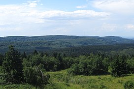
Barnacken (centre), highest point in the Teutoburg Forest, seen from the Egge Tower
1159:
926:
866:
830:
806:
643:
280:
256:
252:
240:
1145:
1129:
1025:
1009:
859:
662:
572:
459:
299:
835:
631:
1105:
895:
871:
847:
738:
722:
567:
269:
214:
210:
1122:
1117:
1093:
811:
782:
667:
524:
519:
161:
48:
403:
205:
stream, which runs in a valley in a southwest to northeast direction through
79:
66:
1134:
727:
691:
602:
547:
536:
997:
232:(408.6 m); they belong to Horn-Bad Meinberg. Its southern spur is the
391:
950:
854:
794:
733:
500:
989:
978:
967:
962:
938:
890:
679:
495:
131:
25:
1033:
883:
41:
376:
Topographic
Information Management, Cologne - NRW GEObasis Division
531:
284:
273:
698:
674:
170:
407:
746:
213:, and the transition between the Teutoburg Forest and the
348:
List of mountains and hills in North Rhine-Westphalia
142:
95:
56:
40:
35:
18:
228:(ca. 385 m) and its western spur, the
1171:Mountains and hills of North Rhine-Westphalia
419:
8:
251:in the southwest and which continues as the
371:
369:
367:
365:
363:
236:(437.5 m) which belongs to Schlangen.
426:
412:
404:
189:The Barnacken is located about 3 km (
15:
224:(387.7 m), its eastern subpeak, the
359:
396:Federal Agency for Nature Conservation
7:
220:Its north-northeastern spur is the
283:, which ultimately flows into the
255:before discharging into the river
14:
243:rises on the Barnacken, near the
114:
1144:
113:
106:
24:
1:
160:446.4 m above
47:446.4 m above
1192:
1070:Thuringian Slate Mountains
1142:
1046:Teutoburg Forest (Osning)
442:
100:
23:
556:Elbe Sandstone Mountains
448:Anterior Bavarian Forest
201:, and northwest of the
197:, part of the town of
177:in the German state of
843:North Palatine Uplands
326:Preußischer Velmerstot
179:North Rhine-Westphalia
1082:Upper Palatine Forest
956:Geiersberg (Breitsol)
525:(Prussian) Velmerstot
321:Lippischer Velmerstot
1111:Paschenburg Mountain
680:Brocken (Blocksberg)
80:51.85611°N 8.90111°E
561:Großer Zschirnstein
263:Weser-Ems watershed
128:Nordrhein-Westfalen
76: /
1075:Großer Farmdenkopf
974:Lusatian Mountains
651:Gladenbach Uplands
619:Sieben-Linden-Berg
291:Points of interest
36:Highest point
1153:
1152:
1058:Thuringian Forest
903:Rothaar Mountains
752:Lauensteiner Kopf
687:Hildesheim Forest
627:Franconian Forest
592:Fichtel Mountains
199:Horn-Bad Meinberg
191:as the crow flies
156:
155:
85:51.85611; 8.90111
1183:
1176:Teutoburg Forest
1148:
985:Zittau Mountains
915:Saalhausen Hills
771:Kaufungen Forest
580:Elster Mountains
428:
421:
414:
405:
398:
389:
383:
373:
331:Falkenburg ruins
175:Teutoburg Forest
164:
151:Teutoburg Forest
146:
117:
116:
110:
91:
90:
88:
87:
86:
81:
77:
74:
73:
72:
69:
51:
28:
16:
1191:
1190:
1186:
1185:
1184:
1182:
1181:
1180:
1166:Central Uplands
1156:
1155:
1154:
1149:
1140:
1063:Großer Beerberg
1039:Großer Feldberg
879:Palatine Forest
819:Lenne Mountains
639:Franconian Jura
483:Bavarian Forest
472:Bohemian Forest
438:
435:Central Uplands
432:
402:
401:
390:
386:
374:
361:
356:
344:
316:Hermannsdenkmal
293:
276:at some point.
265:
193:) southwest of
187:
169:is the highest
159:
144:
138:
137:
136:
135:
134:
125:
124:
123:
122:
118:
84:
82:
78:
75:
70:
67:
65:
63:
62:
52:(1,463 ft)
46:
31:
12:
11:
5:
1189:
1187:
1179:
1178:
1173:
1168:
1158:
1157:
1151:
1150:
1143:
1141:
1139:
1138:
1126:
1114:
1102:
1090:
1078:
1066:
1054:
1042:
1030:
1006:
994:
959:
947:
935:
923:
911:
899:
887:
875:
863:
851:
839:
827:
815:
803:
791:
779:
767:
755:
743:
719:
716:Kasseler Kuppe
707:
695:
683:
671:
663:Goshawk Forest
659:
647:
635:
623:
588:
576:
564:
552:
543:Volcanic Eifel
528:
520:Egge Mountains
516:
508:Ebbe Mountains
504:
492:
468:
456:
443:
440:
439:
433:
431:
430:
423:
416:
408:
400:
399:
384:
358:
357:
355:
352:
351:
350:
343:
340:
339:
338:
333:
328:
323:
318:
313:
307:
302:
292:
289:
264:
261:
186:
183:
162:sea level (NN)
154:
153:
148:
140:
139:
126:
120:
119:
112:
111:
105:
104:
103:
102:
101:
98:
97:
93:
92:
60:
54:
53:
49:sea level (NN)
44:
38:
37:
33:
32:
29:
21:
20:
13:
10:
9:
6:
4:
3:
2:
1188:
1177:
1174:
1172:
1169:
1167:
1164:
1163:
1161:
1147:
1137:
1136:
1132:
1131:
1127:
1125:
1124:
1120:
1119:
1115:
1113:
1112:
1108:
1107:
1103:
1101:
1100:
1096:
1095:
1091:
1089:
1088:
1084:
1083:
1079:
1077:
1076:
1072:
1071:
1067:
1065:
1064:
1060:
1059:
1055:
1053:
1052:
1048:
1047:
1043:
1041:
1040:
1036:
1035:
1031:
1028:
1027:
1023:
1022:
1017:
1016:
1012:
1011:
1007:
1005:
1004:
1000:
999:
995:
992:
991:
990:Lausche (Luž)
987:
986:
981:
980:
979:Lausche (Luž)
976:
975:
970:
969:
968:Lausche (Luž)
965:
964:
960:
958:
957:
953:
952:
948:
946:
945:
941:
940:
936:
934:
933:
932:Großer Ölberg
929:
928:
927:Siebengebirge
924:
922:
921:
917:
916:
912:
910:
909:
905:
904:
900:
898:
897:
893:
892:
888:
886:
885:
881:
880:
876:
874:
873:
869:
868:
867:Ore Mountains
864:
862:
861:
857:
856:
852:
850:
849:
845:
844:
840:
838:
837:
833:
832:
831:Lippe Uplands
828:
826:
825:
821:
820:
816:
814:
813:
809:
808:
804:
802:
801:
797:
796:
792:
790:
789:
785:
784:
780:
778:
777:
773:
772:
768:
766:
765:
761:
760:
756:
754:
753:
749:
748:
744:
741:
740:
736:
735:
730:
729:
725:
724:
720:
718:
717:
713:
712:
711:Hoher Meißner
708:
706:
705:
701:
700:
696:
694:
693:
689:
688:
684:
682:
681:
677:
676:
672:
670:
669:
665:
664:
660:
658:
657:
653:
652:
648:
646:
645:
641:
640:
636:
634:
633:
629:
628:
624:
621:
620:
616:
615:
610:
609:
605:
604:
599:
598:
594:
593:
589:
587:
586:
582:
581:
577:
575:
574:
570:
569:
565:
563:
562:
558:
557:
553:
550:
549:
545:
544:
539:
538:
534:
533:
529:
527:
526:
522:
521:
517:
515:
514:
510:
509:
505:
503:
502:
498:
497:
493:
490:
489:
485:
484:
479:
478:
474:
473:
469:
467:
466:
462:
461:
457:
455:
454:
450:
449:
445:
444:
441:
436:
429:
424:
422:
417:
415:
410:
409:
406:
397:
393:
388:
385:
381:
377:
372:
370:
368:
366:
364:
360:
353:
349:
346:
345:
341:
337:
336:Silberbachtal
334:
332:
329:
327:
324:
322:
319:
317:
314:
311:
308:
306:
303:
301:
298:
297:
296:
290:
288:
286:
282:
277:
275:
271:
262:
260:
258:
254:
250:
246:
242:
237:
235:
231:
227:
226:Kartoffelberg
223:
218:
216:
212:
208:
204:
200:
196:
192:
184:
182:
180:
176:
172:
168:
163:
152:
149:
147:
141:
133:
129:
109:
99:
94:
89:
61:
59:
55:
50:
45:
43:
39:
34:
27:
22:
17:
1133:
1130:Wiehen Hills
1128:
1121:
1116:
1109:
1104:
1097:
1092:
1085:
1080:
1073:
1068:
1061:
1056:
1050:
1049:
1044:
1037:
1032:
1026:Hoher Randen
1024:
1019:
1013:
1010:Swabian Jura
1008:
1001:
996:
988:
983:
977:
972:
966:
961:
954:
949:
942:
937:
930:
925:
918:
913:
906:
901:
894:
889:
882:
877:
870:
865:
860:Katzenbuckel
858:
853:
846:
841:
834:
829:
822:
817:
810:
805:
798:
793:
786:
781:
774:
769:
762:
757:
750:
745:
737:
732:
726:
721:
714:
709:
702:
697:
690:
685:
678:
673:
666:
661:
654:
649:
642:
637:
630:
625:
617:
612:
606:
601:
595:
590:
585:Kapellenberg
583:
578:
573:Eilumer Horn
571:
566:
559:
554:
546:
541:
535:
530:
523:
518:
511:
506:
499:
494:
488:Großer Arber
486:
481:
477:Großer Arber
475:
470:
463:
460:Black Forest
458:
451:
446:
392:Map services
387:
305:Fürstenallee
300:Externsteine
294:
278:
266:
238:
233:
229:
225:
221:
219:
188:
166:
157:
145:Parent range
1106:Weser Hills
1087:Kreuzfelsen
944:Große Blöße
896:Wasserkuppe
872:Fichtelberg
848:Donnersberg
788:Wüstegarten
759:Kaiserstuhl
739:Ellerspring
704:Bloße Zelle
453:Einödriegel
222:Kleine Rigi
215:Eggegebirge
211:Leopoldstal
83: /
58:Coordinates
1160:Categories
1123:Fuchskaute
1118:Westerwald
1094:Vogelsberg
908:Langenberg
812:Kulpenberg
807:Kyffhäuser
783:Kellerwald
776:Hirschberg
668:Hohes Gras
644:Dürrenberg
597:Schneeberg
437:of Germany
354:References
239:The river
203:Silberbach
68:51°51′22″N
1135:Heidbrink
1099:Taufstein
1051:Barnacken
1003:Hohe Egge
836:Köterberg
800:Eisenberg
764:Totenkopf
728:Erbeskopf
692:Griesberg
656:Angelburg
632:Döbraberg
603:Steinwald
548:Ernstberg
537:Hohe Acht
513:Nordhelle
310:Gauseköte
249:Schlangen
185:Geography
167:Barnacken
121:Barnacken
96:Geography
71:8°54′04″E
42:Elevation
19:Barnacken
951:Spessart
855:Odenwald
734:Soonwald
723:Hunsrück
614:Kohlwald
465:Feldberg
342:See also
245:B 1
230:Mordkopf
1015:Lemberg
963:Sudetes
939:Solling
920:Himberg
496:Deister
394:of the
241:Strothe
234:Padberg
217:hills.
207:Veldrom
173:in the
132:Germany
1034:Taunus
1021:Randen
998:Süntel
884:Kalmit
824:Homert
608:Platte
312:(pass)
795:Knüll
532:Eifel
501:Bröhn
285:Rhine
281:Lippe
274:Weser
257:Lippe
253:Thune
891:Rhön
699:Hils
675:Harz
380:info
195:Horn
171:hill
165:the
747:Ith
568:Elm
270:Ems
209:to
158:At
1162::
993:))
611:,
362:^
287:.
259:.
181:.
130:,
1029:)
1018:(
982:(
971:(
742:)
731:(
622:)
600:(
551:)
540:(
491:)
480:(
427:e
420:t
413:v
382:)
378:(
Text is available under the Creative Commons Attribution-ShareAlike License. Additional terms may apply.