57:
41:
692:
749:
428:
129:
64:
311:, was born in Barouk. The village is also well known for its apples and other fruits, and for its many pine and oak forests. Barouk is named after the adjacent mountain of Jabal el-Barouk, which stands 1,943 meters above sea level. The mountain also has the largest nature reserve in Lebanon, the
819:
824:
364:
809:
790:
417:
56:
829:
814:
88:
834:
783:
728:
395:
375:
312:
410:
246:
238:
40:
776:
435:
273:
147:
303:
Historically, Barouk is known for being the "land of good", because of its fountain, Nabeh-el-Barouk. The poet
120:
718:
403:
142:
284:. Its average elevation is 1000 to 1200 meters above sea level and its total land area consists of 2,762
217:
427:
531:
526:
227:
154:
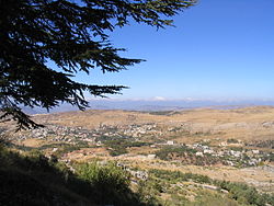
304:
723:
713:
708:
461:
760:
646:
636:
536:
521:
631:
626:
551:
261:
576:
691:
431:
269:
159:
803:
566:
561:
316:
288:. The village had 5,197 registered voters in 2010. Its inhabitants are predominantly
748:
621:
581:
486:
656:
681:
651:
616:
611:
471:
466:
103:
90:
676:
641:
516:
446:
339:
293:
208:
571:
491:
481:
297:
756:
666:
661:
596:
591:
586:
511:
496:
285:
277:
134:
671:
556:
476:
281:
234:
213:
546:
501:
289:
606:
601:
541:
399:
690:
764:
701:
454:
365:"Elections municipales et ikhtiariah au Mont-Liban"
245:
224:
207:
199:
191:
186:
178:
170:
165:
153:
141:
119:
21:
280:. Barouk is located 52 kilometers southeast of
784:
411:
374:. Localiban. 2010. p. 19. Archived from
8:
334:
332:
791:
777:
418:
404:
396:
18:
820:Maronite Christian communities in Lebanon
825:Melkite Christian communities in Lebanon
328:
244:
206:
185:
177:
164:
118:
83:
49:
37:
223:
198:
190:
174:27.62 km (10.66 sq mi)
169:
152:
140:
7:
745:
743:
307:, the writer of the national hymn,
265:
810:Populated places in Chouf District
763:. You can help Knowledge (XXG) by
14:
747:
426:
127:
62:
55:
39:
830:Tourist attractions in Lebanon
63:
1:
729:Al Shouf Cedar Nature Reserve
313:Al Shouf Cedar Nature Reserve
16:Municipality in Mount Lebanon
815:Druze communities in Lebanon
182:1,000 m (3,000 ft)
851:
742:
340:"Fraydis (Chouf) - Barouk"
315:, and contains the oldest
688:
442:
436:Mount Lebanon Governorate
274:Mount Lebanon Governorate
84:
50:
38:
31:
25:
835:Lebanon geography stubs
719:Deir el Qamar Synagogue
346:. Localiban. 2008-01-11
76:Location within Lebanon
759:location article is a
695:
268:) is a village in the
694:
226: • Summer (
104:33.70833°N 35.67750°E
532:Bourjein et Marjiyat
319:forest in Lebanon.
203:(Registered voters)
100: /
696:
455:Towns and villages
192: • Total
171: • Total
109:33.70833; 35.67750
26:فريديس الشوف-باروك
772:
771:
737:
736:
724:Fakhredine Mosque
714:Fakhredine Palace
709:Beiteddine Palace
702:Notable landmarks
309:Kulluna lel watan
255:
254:
45:Skyline of Barouk
842:
793:
786:
779:
751:
744:
632:Mazraat el Daher
627:Mazraat el-Chouf
430:
420:
413:
406:
397:
390:
389:
387:
386:
380:
369:
361:
355:
354:
352:
351:
336:
267:
231:
137:
133:
131:
130:
115:
114:
112:
111:
110:
105:
101:
98:
97:
96:
93:
66:
65:
59:
43:
19:
850:
849:
845:
844:
843:
841:
840:
839:
800:
799:
798:
797:
740:
738:
733:
697:
686:
552:Dahr El Maghara
450:
438:
424:
394:
393:
384:
382:
378:
367:
363:
362:
358:
349:
347:
338:
337:
330:
325:
225:
128:
126:
125:
108:
106:
102:
99:
94:
91:
89:
87:
86:
80:
79:
78:
77:
74:
73:
72:
71:
67:
46:
34:
27:
24:
17:
12:
11:
5:
848:
846:
838:
837:
832:
827:
822:
817:
812:
802:
801:
796:
795:
788:
781:
773:
770:
769:
752:
735:
734:
732:
731:
726:
721:
716:
711:
705:
703:
699:
698:
689:
687:
685:
684:
679:
674:
669:
664:
659:
654:
649:
644:
639:
634:
629:
624:
619:
614:
609:
604:
599:
594:
589:
584:
579:
574:
569:
564:
559:
554:
549:
544:
539:
534:
529:
524:
519:
514:
509:
504:
499:
494:
489:
484:
479:
474:
469:
464:
458:
456:
452:
451:
443:
440:
439:
432:Chouf District
425:
423:
422:
415:
408:
400:
392:
391:
356:
327:
326:
324:
321:
305:Rachid Nakhleh
270:Chouf District
253:
252:
249:
243:
242:
232:
222:
221:
211:
205:
204:
201:
197:
196:
193:
189:
188:
184:
183:
180:
176:
175:
172:
168:
167:
163:
162:
157:
151:
150:
145:
139:
138:
123:
117:
116:
82:
81:
75:
69:
68:
61:
60:
54:
53:
52:
51:
48:
47:
44:
36:
35:
32:
29:
28:
22:
15:
13:
10:
9:
6:
4:
3:
2:
847:
836:
833:
831:
828:
826:
823:
821:
818:
816:
813:
811:
808:
807:
805:
794:
789:
787:
782:
780:
775:
774:
768:
766:
762:
758:
753:
750:
746:
741:
730:
727:
725:
722:
720:
717:
715:
712:
710:
707:
706:
704:
700:
693:
683:
680:
678:
675:
673:
670:
668:
665:
663:
660:
658:
655:
653:
650:
648:
645:
643:
640:
638:
635:
633:
630:
628:
625:
623:
620:
618:
615:
613:
610:
608:
605:
603:
600:
598:
595:
593:
590:
588:
585:
583:
580:
578:
575:
573:
570:
568:
567:Deir el Qamar
565:
563:
560:
558:
555:
553:
550:
548:
545:
543:
540:
538:
535:
533:
530:
528:
525:
523:
520:
518:
515:
513:
510:
508:
505:
503:
500:
498:
495:
493:
490:
488:
485:
483:
480:
478:
475:
473:
470:
468:
465:
463:
460:
459:
457:
453:
449:
448:
441:
437:
433:
429:
421:
416:
414:
409:
407:
402:
401:
398:
381:on 2015-07-24
377:
373:
366:
360:
357:
345:
341:
335:
333:
329:
322:
320:
318:
314:
310:
306:
301:
299:
295:
291:
287:
283:
279:
275:
271:
263:
259:
250:
248:
240:
236:
233:
229:
219:
215:
212:
210:
202:
194:
181:
173:
161:
158:
156:
149:
148:Mount Lebanon
146:
144:
136:
124:
122:
113:
85:Coordinates:
58:
42:
30:
20:
765:expanding it
754:
739:
622:Kfar Nabrakh
582:Haret Jandal
506:
445:
383:. Retrieved
376:the original
371:
359:
348:. Retrieved
343:
308:
302:
300:Christians.
257:
256:
247:Dialing code
33:Municipality
143:Governorate
107: /
804:Categories
682:Zaarourieh
617:Kfarfakoud
612:Kahlouniye
472:Ain Zhalta
467:Ain W Zain
385:2016-02-12
350:2016-03-30
323:References
187:Population
95:35°40′39″E
92:33°42′30″N
677:Symkanieh
642:Moukhtara
577:El Foûâra
517:Beitedine
487:Baadarâne
447:Beitedine
444:Capital:
372:Localiban
344:Localiban
209:Time zone
179:Elevation
572:Dibbiyeh
527:El Bireh
492:Baakleen
482:Ammatour
462:Ain Qani
294:Maronite
286:hectares
155:District
757:Lebanon
667:Serjbel
662:Rmeileh
652:Na'ameh
647:Mtolleh
637:Maasser
597:Jdaideh
592:Jahlieh
587:Gharife
537:Boutmeh
522:Beykoun
512:Batloun
497:Bakaata
298:Melkite
278:Lebanon
135:Lebanon
121:Country
672:Shheem
562:Daraya
557:Damour
507:Barouk
477:Ainbal
282:Beirut
262:Arabic
258:Barouk
200:
132:
70:Barouk
23:Barouk
755:This
547:Bsaba
502:Barja
379:(pdf)
368:(PDF)
317:cedar
290:Druze
266:باروك
235:UTC+3
214:UTC+2
195:5,197
160:Chouf
761:stub
657:Niha
607:Joun
602:Jieh
542:Brih
296:and
292:and
251:+961
239:EEST
166:Area
276:in
272:of
228:DST
218:EET
806::
434:,
370:.
342:.
331:^
264::
792:e
785:t
778:v
767:.
419:e
412:t
405:v
388:.
353:.
260:(
241:)
237:(
230:)
220:)
216:(
Text is available under the Creative Commons Attribution-ShareAlike License. Additional terms may apply.