273:
382:
280:
Barentsøya has an approximately square shape, with maximum lengths and widths of about fifty kilometers, and an area of 1,288 km (497 sq mi). A significant part of the island, more than 500 km (190 sq mi), is glaciated. The ice cap of
38:
256:
who, despite discovering
Svalbard, never sighted Barentsøya itself. The name "Barents Land" was only given after an 1865 Swedish expedition. Previously, Dutch whaling captains had referred to it on maps as
342:
is an ice-free mountainous area extending over a length of about thirteen kilometers at the northern part of the island. The westernmost point of the island is the headland of
1794:
1003:
950:
1533:
1965:
1595:
971:
1574:
1278:
1709:
1528:
1518:
225:
69:
1787:
696:
406:
1605:
1538:
1513:
1500:
1761:
1704:
1686:
1625:
1523:
1294:
1164:
1106:
1635:
1600:
996:
1960:
1780:
1666:
1640:
1369:
1073:
1859:
1676:
1630:
1610:
691:. Vol. 7. Stavanger: The Norwegian Hydrographic Service and The Norwegian Polar Institute. 1988. p. 360.
1904:
1620:
1400:
916:
891:
866:
841:
816:
791:
766:
741:
716:
667:
642:
617:
592:
567:
542:
517:
492:
467:
320:
989:
1157:
1508:
1260:
1121:
1031:
1026:
1955:
371:
1724:
1696:
1078:
1068:
1051:
302:
1869:
1819:
1590:
1470:
1435:
1304:
1111:
1093:
1036:
1745:
1569:
1554:
1349:
1268:
1083:
1063:
1046:
1041:
306:
140:
1714:
355:
221:
206:
351:
1874:
1480:
1273:
968:
692:
327:
282:
210:
1834:
1719:
1319:
1250:
1190:
1415:
1324:
1116:
975:
663:
1460:
613:
389:
Around 43 percent of the island's 1,288 square kilometres (497 sq mi) area is
1929:
1924:
1889:
1879:
1814:
1681:
1564:
1405:
1374:
1344:
298:
253:
214:
712:
488:
1949:
1934:
1884:
1839:
1661:
1485:
1450:
1430:
1395:
1225:
1215:
1152:
912:
538:
367:
359:
290:
812:
638:
563:
513:
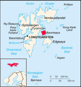
205:. To the north, in the sound between Barentsøya and Spitsbergen, lies the island of
1824:
1729:
1440:
1425:
1410:
1309:
1220:
1147:
1101:
1056:
862:
787:
588:
347:
294:
286:
57:
1909:
1894:
1364:
1339:
887:
737:
463:
272:
837:
1899:
1864:
1849:
1803:
1656:
1465:
1455:
1445:
1359:
1354:
1329:
1240:
1200:
1185:
1142:
1137:
762:
343:
331:
249:
202:
264:
In 1936, Norway built four cabins on the island to formally establish control.
1919:
1914:
1854:
1829:
1559:
1490:
1334:
1314:
1245:
1210:
335:
237:
233:
198:
37:
17:
1772:
319:, is the highest mountain of Barentsøya, and is named after German scientist
84:
71:
1420:
1235:
1230:
1169:
375:
1844:
1195:
1012:
393:, and much of the surface rock has been eroded over millions of years by
363:
339:
316:
190:
104:
1205:
394:
390:
229:
381:
1615:
194:
186:
183:
271:
432:
358:
is located to the southeast. The largest lakes of the island are
326:
At the northern side of
Barentsøya is the ice-free peninsula of
1776:
985:
1671:
285:
covers a large part of the island, with the largest offspring
276:
July NASA 2002 satellite photograph of
Edgeoya and Barentsøya
981:
301:(southeast). Barentsjøkulen has the two large ice domes of
346:. At the southern part of Barentsøya are the mountains of
689:
Arctic Pilot: Sailing directions
Svalbard–Jan Mayen
315:
is a nunatak of
Barentsjøkulen. It has a height of 590
1754:
1738:
1695:
1649:
1583:
1547:
1499:
1383:
1287:
1259:
1178:
1130:
1092:
1019:
165:
160:
146:
136:
128:
120:
110:
100:
63:
53:
48:
385:Nesting at Dørstubukta in northeast Barentsøya
1788:
997:
8:
116:558 km (215 sq mi) glaciated.
30:
956:, globalTwitcher.com, ed. Nicklas Stromberg
1795:
1781:
1773:
1004:
990:
982:
213:separating Barents Island from Edgeøya is
36:
29:
27:Island in the Svalbard archipelago, Norway
380:
261:("Southeastern Land") as early as 1710.
426:
424:
422:
418:
7:
1596:Amundsen-Nobile Climate Change Tower
114:1,288 km (497 sq mi)
25:
1606:Dirigibile Italia Arctic Station
1762:2011 Svalbard polar bear attack
1710:Ny-Ålesund Airport, Hamnerabben
1705:Barentsburg Heliport, Heerodden
978:(URL accessed 26 December 2008)
664:"Schweinfurthberget (Svalbard)"
232:for several species, including
226:Søraust-Svalbard Nature Reserve
1107:Longyearbyen Community Council
222:no permanent human inhabitants
1:
1966:Uninhabited islands of Norway
614:"Peer Gyntslottet (Svalbard)"
1667:Kongsfjord Telemetry Station
1601:Arctic Yellow River Station
969:Svalbard Images: Barentsøya
713:"Frankenhalvøya (Svalbard)"
489:"Barentsjøkulen (Svalbard)"
248:The island was named after
124:205 km (127.4 mi)
1982:
1804:Islands of the Barents Sea
913:"Dalskilvatnet (Svalbard)"
539:"Duckwitzbreen (Svalbard)"
1810:
1621:Norwegian Polar Institute
917:Norwegian Polar Institute
892:Norwegian Polar Institute
867:Norwegian Polar Institute
842:Norwegian Polar Institute
817:Norwegian Polar Institute
813:"Krefftberget (Svalbard)"
792:Norwegian Polar Institute
767:Norwegian Polar Institute
742:Norwegian Polar Institute
717:Norwegian Polar Institute
668:Norwegian Polar Institute
643:Norwegian Polar Institute
639:"Solveigdomen (Svalbard)"
618:Norwegian Polar Institute
593:Norwegian Polar Institute
568:Norwegian Polar Institute
564:"Freemanbreen (Svalbard)"
543:Norwegian Polar Institute
518:Norwegian Polar Institute
514:"Besselsbreen (Svalbard)"
493:Norwegian Polar Institute
468:Norwegian Polar Institute
407:List of islands of Norway
321:Georg August Schweinfurth
151:
132:666 m (2185 ft)
44:
35:
949:C. Michael Hogan (2008)
863:"Jeppeberget (Svalbard)"
788:"Mistakodden (Svalbard)"
589:"Hübnerbreen (Svalbard)"
334:at the western side and
1509:Forlandet National Park
888:"Veslemjøsa (Svalbard)"
738:"Dorstbukta (Svalbard)"
464:"Barentsøya (Svalbard)"
435:. Store norske leksikon
370:between the valleys of
1905:Store Kamøya, Nordkapp
838:"Høgrinden (Svalbard)"
453:C. Michael Hogan, 2008
386:
277:
129:Highest elevation
1725:Svalbard Rocket Range
1529:Northwest Spitsbergen
1524:Nordre Isfjorden Land
763:"Grimheia (Svalbard)"
384:
275:
1870:Mezhdusharsky Island
1860:Lille Ekkerøy, Vadsø
1626:Polish Polar Station
1591:Arctic World Archive
1471:Wedel Jarlsberg Land
224:. It is part of the
209:. To the south, the
1961:Islands of Svalbard
1746:Longyearbyen School
1555:Arctic Coal Company
1350:Prins Karls Forland
81: /
32:
1715:Pyramiden Heliport
1650:Telecommunications
1534:Sassen–Bünsow Land
1514:Indre Wijdefjorden
1179:Former settlements
974:2004-12-07 at the
387:
312:Schweinfurthberget
309:. The mountain of
278:
137:Highest point
1943:
1942:
1875:Morzhovets Island
1770:
1769:
1677:Satellite Station
1636:University Centre
1519:Nordenskiöld Land
1481:Gustav Adolf Land
1436:Nordenskiöld Land
173:
172:
85:78.417°N 21.450°E
16:(Redirected from
1973:
1797:
1790:
1783:
1774:
1720:Svalbard Airport
1641:Zeppelin Station
1477:
1392:
1370:Thousand Islands
1295:Amsterdam Island
1006:
999:
992:
983:
937:
934:
928:
927:
925:
923:
909:
903:
902:
900:
898:
884:
878:
877:
875:
873:
859:
853:
852:
850:
848:
834:
828:
827:
825:
823:
809:
803:
802:
800:
798:
784:
778:
777:
775:
773:
759:
753:
752:
750:
748:
734:
728:
727:
725:
723:
709:
703:
702:
685:
679:
678:
676:
674:
660:
654:
653:
651:
649:
635:
629:
628:
626:
624:
610:
604:
603:
601:
599:
585:
579:
578:
576:
574:
560:
554:
553:
551:
549:
535:
529:
528:
526:
524:
510:
504:
503:
501:
499:
485:
479:
478:
476:
474:
460:
454:
451:
445:
444:
442:
440:
428:
314:
313:
303:Peer Gyntslottet
259:Zuyd Ooster Land
197:, lying between
178:, anglicized as
96:
95:
93:
92:
91:
86:
82:
79:
78:
77:
74:
40:
33:
21:
1981:
1980:
1976:
1975:
1974:
1972:
1971:
1970:
1946:
1945:
1944:
1939:
1806:
1801:
1771:
1766:
1750:
1734:
1691:
1645:
1611:Himadri Station
1579:
1543:
1539:Sør-Spitsbergen
1495:
1475:
1416:Haakon VII Land
1390:
1379:
1325:Kong Karls Land
1283:
1279:Protected areas
1255:
1174:
1126:
1088:
1015:
1010:
976:Wayback Machine
965:
954:Ursus maritimus
946:
941:
940:
936:Svalbard Images
935:
931:
921:
919:
911:
910:
906:
896:
894:
886:
885:
881:
871:
869:
861:
860:
856:
846:
844:
836:
835:
831:
821:
819:
811:
810:
806:
796:
794:
786:
785:
781:
771:
769:
761:
760:
756:
746:
744:
736:
735:
731:
721:
719:
711:
710:
706:
699:
687:
686:
682:
672:
670:
662:
661:
657:
647:
645:
637:
636:
632:
622:
620:
612:
611:
607:
597:
595:
587:
586:
582:
572:
570:
562:
561:
557:
547:
545:
537:
536:
532:
522:
520:
512:
511:
507:
497:
495:
487:
486:
482:
472:
470:
462:
461:
457:
452:
448:
438:
436:
430:
429:
420:
415:
403:
311:
310:
270:
246:
220:Barentsøya has
193:archipelago of
156:
115:
89:
87:
83:
80:
75:
72:
70:
68:
67:
28:
23:
22:
15:
12:
11:
5:
1979:
1977:
1969:
1968:
1963:
1958:
1948:
1947:
1941:
1940:
1938:
1937:
1932:
1930:Wilhelm Island
1927:
1925:Vaygach Island
1922:
1917:
1912:
1907:
1902:
1897:
1892:
1890:Severny Island
1887:
1882:
1880:Nordaustlandet
1877:
1872:
1867:
1862:
1857:
1852:
1847:
1842:
1837:
1832:
1827:
1822:
1817:
1811:
1808:
1807:
1802:
1800:
1799:
1792:
1785:
1777:
1768:
1767:
1765:
1764:
1758:
1756:
1752:
1751:
1749:
1748:
1742:
1740:
1736:
1735:
1733:
1732:
1727:
1722:
1717:
1712:
1707:
1701:
1699:
1693:
1692:
1690:
1689:
1687:Undersea Cable
1684:
1682:Svalbard Radio
1679:
1674:
1669:
1664:
1659:
1653:
1651:
1647:
1646:
1644:
1643:
1638:
1633:
1628:
1623:
1618:
1616:IndARC Station
1613:
1608:
1603:
1598:
1593:
1587:
1585:
1581:
1580:
1578:
1577:
1572:
1567:
1562:
1557:
1551:
1549:
1545:
1544:
1542:
1541:
1536:
1531:
1526:
1521:
1516:
1511:
1505:
1503:
1501:National parks
1497:
1496:
1494:
1493:
1488:
1483:
1478:
1476:Nordaustlandet
1473:
1468:
1463:
1458:
1453:
1448:
1443:
1438:
1433:
1428:
1423:
1418:
1413:
1408:
1403:
1398:
1393:
1387:
1385:
1381:
1380:
1378:
1377:
1375:Wilhelm Island
1372:
1367:
1362:
1357:
1352:
1347:
1345:Nordaustlandet
1342:
1337:
1332:
1327:
1322:
1317:
1312:
1307:
1302:
1297:
1291:
1289:
1285:
1284:
1282:
1281:
1276:
1271:
1265:
1263:
1257:
1256:
1254:
1253:
1248:
1243:
1238:
1233:
1228:
1223:
1218:
1213:
1208:
1203:
1198:
1193:
1188:
1182:
1180:
1176:
1175:
1173:
1172:
1167:
1162:
1161:
1160:
1150:
1145:
1140:
1134:
1132:
1128:
1127:
1125:
1124:
1119:
1114:
1109:
1104:
1098:
1096:
1090:
1089:
1087:
1086:
1081:
1076:
1071:
1066:
1061:
1060:
1059:
1049:
1044:
1039:
1034:
1029:
1023:
1021:
1017:
1016:
1011:
1009:
1008:
1001:
994:
986:
980:
979:
964:
963:External links
961:
960:
959:
945:
942:
939:
938:
929:
904:
879:
854:
829:
804:
779:
754:
729:
704:
697:
680:
655:
630:
605:
580:
555:
530:
505:
480:
455:
446:
417:
416:
414:
411:
410:
409:
402:
399:
328:Frankenhalvøya
283:Barentsjøkulen
269:
266:
254:Willem Barents
245:
242:
180:Barents Island
171:
170:
167:
163:
162:
158:
157:
152:
149:
148:
147:Administration
144:
143:
138:
134:
133:
130:
126:
125:
122:
118:
117:
112:
108:
107:
102:
98:
97:
90:78.417; 21.450
65:
61:
60:
55:
51:
50:
46:
45:
42:
41:
26:
24:
18:Barents Island
14:
13:
10:
9:
6:
4:
3:
2:
1978:
1967:
1964:
1962:
1959:
1957:
1954:
1953:
1951:
1936:
1935:Yuzhny Island
1933:
1931:
1928:
1926:
1923:
1921:
1918:
1916:
1913:
1911:
1908:
1906:
1903:
1901:
1898:
1896:
1893:
1891:
1888:
1886:
1885:Novaya Zemlya
1883:
1881:
1878:
1876:
1873:
1871:
1868:
1866:
1863:
1861:
1858:
1856:
1853:
1851:
1848:
1846:
1843:
1841:
1840:Kildin Island
1838:
1836:
1833:
1831:
1828:
1826:
1823:
1821:
1818:
1816:
1813:
1812:
1809:
1805:
1798:
1793:
1791:
1786:
1784:
1779:
1778:
1775:
1763:
1760:
1759:
1757:
1753:
1747:
1744:
1743:
1741:
1737:
1731:
1728:
1726:
1723:
1721:
1718:
1716:
1713:
1711:
1708:
1706:
1703:
1702:
1700:
1698:
1694:
1688:
1685:
1683:
1680:
1678:
1675:
1673:
1670:
1668:
1665:
1663:
1662:Isfjord Radio
1660:
1658:
1655:
1654:
1652:
1648:
1642:
1639:
1637:
1634:
1632:
1629:
1627:
1624:
1622:
1619:
1617:
1614:
1612:
1609:
1607:
1604:
1602:
1599:
1597:
1594:
1592:
1589:
1588:
1586:
1582:
1576:
1573:
1571:
1568:
1566:
1563:
1561:
1558:
1556:
1553:
1552:
1550:
1546:
1540:
1537:
1535:
1532:
1530:
1527:
1525:
1522:
1520:
1517:
1515:
1512:
1510:
1507:
1506:
1504:
1502:
1498:
1492:
1489:
1487:
1486:Gustav V Land
1484:
1482:
1479:
1474:
1472:
1469:
1467:
1464:
1462:
1459:
1457:
1454:
1452:
1451:Oscar II Land
1449:
1447:
1444:
1442:
1439:
1437:
1434:
1432:
1431:Nathorst Land
1429:
1427:
1424:
1422:
1419:
1417:
1414:
1412:
1409:
1407:
1404:
1402:
1399:
1397:
1396:Albert I Land
1394:
1389:
1388:
1386:
1382:
1376:
1373:
1371:
1368:
1366:
1363:
1361:
1358:
1356:
1353:
1351:
1348:
1346:
1343:
1341:
1338:
1336:
1333:
1331:
1328:
1326:
1323:
1321:
1318:
1316:
1313:
1311:
1308:
1306:
1303:
1301:
1298:
1296:
1293:
1292:
1290:
1286:
1280:
1277:
1275:
1272:
1270:
1267:
1266:
1264:
1262:
1258:
1252:
1251:Ytre Norskøya
1249:
1247:
1244:
1242:
1239:
1237:
1234:
1232:
1229:
1227:
1224:
1222:
1219:
1217:
1216:Isfjord Radio
1214:
1212:
1209:
1207:
1204:
1202:
1199:
1197:
1194:
1192:
1189:
1187:
1184:
1183:
1181:
1177:
1171:
1168:
1166:
1163:
1159:
1156:
1155:
1154:
1151:
1149:
1146:
1144:
1141:
1139:
1136:
1135:
1133:
1129:
1123:
1120:
1118:
1115:
1113:
1110:
1108:
1105:
1103:
1100:
1099:
1097:
1095:
1091:
1085:
1082:
1080:
1077:
1075:
1072:
1070:
1067:
1065:
1062:
1058:
1055:
1054:
1053:
1050:
1048:
1045:
1043:
1040:
1038:
1035:
1033:
1030:
1028:
1025:
1024:
1022:
1018:
1014:
1007:
1002:
1000:
995:
993:
988:
987:
984:
977:
973:
970:
967:
966:
962:
958:
957:
953:
948:
947:
943:
933:
930:
918:
914:
908:
905:
893:
889:
883:
880:
868:
864:
858:
855:
843:
839:
833:
830:
818:
814:
808:
805:
793:
789:
783:
780:
768:
764:
758:
755:
743:
739:
733:
730:
718:
714:
708:
705:
700:
698:82-90653-06-9
694:
690:
684:
681:
669:
665:
659:
656:
644:
640:
634:
631:
619:
615:
609:
606:
594:
590:
584:
581:
569:
565:
559:
556:
544:
540:
534:
531:
519:
515:
509:
506:
494:
490:
484:
481:
469:
465:
459:
456:
450:
447:
434:
427:
425:
423:
419:
412:
408:
405:
404:
400:
398:
396:
392:
383:
379:
377:
373:
369:
368:Dalskilvatnet
365:
361:
357:
353:
349:
345:
341:
338:to the east.
337:
333:
329:
324:
322:
318:
308:
304:
300:
297:(south), and
296:
292:
291:Duckwitzbreen
288:
284:
274:
267:
265:
262:
260:
255:
251:
243:
241:
239:
235:
231:
227:
223:
218:
216:
215:Freemansundet
212:
208:
204:
200:
196:
192:
188:
185:
181:
177:
168:
164:
159:
155:
150:
145:
142:
139:
135:
131:
127:
123:
119:
113:
109:
106:
103:
99:
94:
66:
62:
59:
56:
52:
47:
43:
39:
34:
19:
1825:Dolgy Island
1730:Svea Airport
1575:Store Norske
1461:Sørkapp Land
1441:Ny-Friesland
1426:James I Land
1411:Dickson Land
1310:Danes Island
1299:
1221:Kobbefjorden
1165:Isbjørnhamna
1148:Longyearbyen
1057:Newtontoppen
955:
952:Polar Bear:
951:
932:
920:. Retrieved
907:
895:. Retrieved
882:
870:. Retrieved
857:
845:. Retrieved
832:
820:. Retrieved
807:
795:. Retrieved
782:
770:. Retrieved
757:
745:. Retrieved
732:
720:. Retrieved
707:
688:
683:
671:. Retrieved
658:
646:. Retrieved
633:
621:. Retrieved
608:
596:. Retrieved
583:
571:. Retrieved
558:
546:. Retrieved
533:
521:. Retrieved
508:
496:. Retrieved
483:
471:. Retrieved
458:
449:
437:. Retrieved
433:"Barentsøya"
431:Susan Barr.
388:
348:Krefftberget
325:
307:Solveigdomen
295:Freemanbreen
287:Besselsbreen
279:
263:
258:
247:
228:and forms a
219:
207:Kükenthaløya
179:
175:
174:
161:Demographics
153:
141:Solveigdomen
58:Arctic Ocean
1900:Spitsbergen
1820:Bear Island
1657:Hopen Radio
1466:Torell Land
1456:Sabine Land
1446:Olav V Land
1406:Bünsow Land
1401:Andrée Land
1391:Spitsbergen
1360:Spitsbergen
1305:Bear Island
1261:Environment
1241:Smeerenburg
1186:Advent City
1143:Hopen Radio
1138:Barentsburg
1131:Settlements
1122:Visa policy
1032:Archaeology
1027:Agriculture
922:12 February
897:12 February
872:12 February
847:12 February
822:12 February
797:12 February
772:12 February
747:12 February
722:12 February
673:12 February
648:12 February
623:12 February
598:12 February
573:12 February
548:12 February
523:12 February
498:12 February
473:12 February
439:November 1,
356:Jeppeberget
344:Mistakodden
332:Ginevra Bay
299:Hübnerbreen
234:polar bears
203:Spitsbergen
101:Archipelago
88: /
64:Coordinates
1956:Barentsøya
1950:Categories
1815:Barentsøya
1631:Seed Vault
1560:Arktikugol
1491:Orvin Land
1384:Land areas
1300:Barentsøya
1246:Virgohamna
1226:Lægerneset
1211:Hiorthhamn
1191:Bölscheøya
1153:Ny-Ålesund
1084:In fiction
944:Line notes
413:References
395:glaciation
360:Veslemjøsa
336:Dorstbukta
330:, between
238:kittiwakes
176:Barentsøya
166:Population
31:Barentsøya
1910:Svenskøya
1895:Skogerøya
1739:Education
1697:Transport
1570:Kings Bay
1548:Companies
1421:Heer Land
1365:Svenskøya
1236:Pyramiden
1231:Ny-London
1170:Sveagruva
1079:Transport
1069:Languages
1052:Geography
391:glaciated
376:Grimdalen
352:Høgrinden
289:(north),
268:Geography
252:explorer
121:Coastline
49:Geography
1865:Magerøya
1850:Kongsøya
1845:Kolguyev
1584:Research
1565:Bjørnøen
1355:Sjuøyane
1330:Kongsøya
1201:Gåshamna
1196:Finneset
1112:Governor
1094:Politics
1037:Cannabis
1013:Svalbard
972:Archived
401:See also
372:Sjodalen
364:Heimarka
354:, while
340:Grimheia
317:m.a.s.l.
293:(west),
191:Svalbard
182:, is an
105:Svalbard
54:Location
1920:Vardøya
1915:Vadsøya
1855:Kvitøya
1830:Edgeøya
1755:History
1335:Kvitøya
1315:Edgeøya
1288:Islands
1269:Climate
1206:Grumant
1158:history
1074:Museums
1064:History
1047:Economy
1042:Outline
1020:General
244:History
230:habitat
199:Edgeøya
189:in the
76:21°27′E
73:78°25′N
1340:Lågøya
1117:Treaty
695:
366:, and
195:Norway
187:island
184:Arctic
154:Norway
1835:Hopen
1320:Hopen
1274:Flora
250:Dutch
211:sound
924:2015
899:2015
874:2015
849:2015
824:2015
799:2015
774:2015
749:2015
724:2015
693:ISBN
675:2015
650:2015
625:2015
600:2015
575:2015
550:2015
525:2015
500:2015
475:2015
441:2016
374:and
350:and
305:and
236:and
201:and
111:Area
1672:.sj
1102:Act
397:.
362:in
217:.
1952::
915:.
890:.
865:.
840:.
815:.
790:.
765:.
740:.
715:.
666:.
641:.
616:.
591:.
566:.
541:.
516:.
491:.
466:.
421:^
378:.
323:.
240:.
1796:e
1789:t
1782:v
1005:e
998:t
991:v
926:.
901:.
876:.
851:.
826:.
801:.
776:.
751:.
726:.
701:.
677:.
652:.
627:.
602:.
577:.
552:.
527:.
502:.
477:.
443:.
169:0
20:)
Text is available under the Creative Commons Attribution-ShareAlike License. Additional terms may apply.