71:
1286:
249:
26:
33:
40:
349:
59:
1225:
78:
221:, a group of small islands and rocks, are situated off the coast just north of Rookery Bay. Martin Valley trends northeast–southwest across the peninsula from Rookery Bay to Cumberland East Bay. It was originally called "Three Lakes Valley", but to avoid confusion with
197:(DI) personnel as a result of surveys during the period 1926–30. 1.5 nmi (3 km) east-southeast off the coast of Barff Point is Alert Rock, a submerged rock marked by breakers. It was charted in 1929 by DI personnel, who named it after the
378:. Tucked south of it is Horseshoe Bay, .5 nmi (0.93 km) wide, first charted by DI personnel. East-southeast of the cape is a rocky ridge called Nansen Reef, submerged to a depth of about 6 ft 7 in (2 m). It was named after
212:
stands inland 1 nmi (1.9 km) southwest. Cape
Douglas ends at Lucas Point, which marks the west side of a small bay called Rookery Bay, bordered on the east by Rookery Point. The bay and its headlands appear to be first named on a 1930
336:
Reindeer Valley cuts southwest across the peninsula between the head of
Godthul and Sandebugten in Cumberland East Bay. It was surveyed by the SGS between 1951 and 1957, and named by UK-APC because Norwegian whalers introduced
70:
1273:
263:
East of
Rookery Point, Skua Point, first named on a 1930 British Admiralty chart, marks the western extent of Cobblers Cove, a small cove providing an anchorage. Babe Island lies in the entrance to the cove, with
1331:
1378:
188:
North off Barff Point, .25 nmi (0.46 km) from the coast, are the Right Whale Rocks, separated from the point by Merton
Passage. The name Merton was originally given to the rocks by personnel of
1356:
315:
sits on the south edge of the harbor. Briggs Point projects into
Godthul from its eastern shore, dividing it from Alsford Bay to the east. The name appears on a DI chart from 1929, and is probably for
407:. The name Penguin Point was probably applied to this feature by DI personnel in 1930. Following the SGS, it was recommended that the name be altered to avoid confusion with other features named for
1321:
1316:
173:
The coastline of Barff
Peninsula is irregular and marked by indented bays and coves, with headlands and points projecting out into the sea. Many of these features have been charted and named.
1266:
1341:
1336:
1259:
280:. An English form of this name, Cobblers Cove, was approved. To the south, Long Point divides Cobblers Cove from Godthul. It was charted in 1928 by a Norwegian expedition under
1326:
396:, a former whaling station, sits 1 nmi (2 km) to the south. Kelp-infested Penguin Bay lies just southeast. Its name first appears on a 1931 British Admiralty chart.
623:
1291:
222:
1251:
459:
1561:
1815:
1643:
450:
204:
Continuing east along the coast, the next major feature is Cape
Douglas. It was charted by DI in 1926–1930 and probably named after Sir
1200:
1174:
1148:
1093:
1015:
911:
804:
752:
726:
700:
648:
538:
1122:
1067:
1041:
963:
937:
885:
833:
778:
674:
567:
509:
319:, a member of the DI survey party. Alsford is a small bay between Briggs Point and Cape George, charted by DI in 1929 and named after
230:
989:
859:
593:
483:
445:
311:
1 mile (1.6 km) long entered between Long Point to the north and Cape George to the south. It once served as a whaling station.
176:
Cave Point is a headland lying 0.5 nautical miles (1 km) southwest of Barff Point. The name appears to be first used on a 1929
1820:
375:
1233:
455:
1754:
268:
separating the island from
Cobblers Cove. Both were charted by DI personnel in 1929, who named the cove "Pleasant Cove". The
98:
1485:
1779:
1515:
1490:
367:
1229:
1520:
1475:
1465:
1399:
234:
209:
165:, sketched a map of Cumberland Bay in 1906. Barff Point is considered the eastern headland of East Cumberland Bay.
1470:
1383:
1495:
1439:
238:
194:
1346:
265:
392:
0.7 nmi (1.3 km) long. The name first appears on a DI chart, but may reflect an earlier naming.
320:
205:
1638:
379:
32:
25:
281:
1525:
1444:
1368:
412:
404:
269:
135:
1505:
1434:
142:
to Barff Point, its farthest extremity. It was probably first seen by the
British expedition under
131:
323:
1769:
1584:
1500:
1351:
316:
304:
151:
1616:
1598:
1571:
1419:
1302:
312:
214:
177:
155:
139:
1729:
1579:
619:
289:
285:
1704:
1694:
1668:
1530:
1460:
1789:
1784:
1764:
1759:
1749:
1714:
1689:
1630:
1611:
1556:
1551:
1535:
248:
218:
146:
in 1775. The peninsula as a whole takes its name from Barff Point, which was named for
276:, because it was first entered in thick fog by a Norwegian gunner who had once been a
84:
1809:
1724:
1606:
1429:
1424:
1361:
393:
359:
353:
327:
1774:
1709:
1673:
1648:
1510:
1480:
226:
272:(SGS) of 1951–1952 reported that this feature was known to whalers and sealers as
399:
To the south, prominent Tijuca Point forms the northwest side of the entrance of
1794:
1739:
1734:
1719:
162:
371:
147:
143:
16:
Peninsula forming the east margin of
Cumberland East Bay, South Georgia Island
113:
100:
1744:
1404:
400:
348:
277:
242:
127:
338:
1409:
408:
300:
257:
1414:
422:
418:
342:
388:
Continuing southward, the next major feature is Johannsen Loch, a
347:
284:, then recharted in 1929 by DI personnel, who named the point for
247:
389:
1255:
1373:
620:
South Georgia and the South Sandwich Islands (SGSSI) Gazetteer
308:
138:. It is 8 miles (13 km) long and extends northwest from
1245:
385:, which struck this reef and sank on 10 November 1906.
1682:
1661:
1629:
1597:
1570:
1544:
1453:
1392:
1309:
1248:– detailed topographic map of South Georgia Island
208:, a member of the Discovery Committee, 1928–1939.
411:. The name Tijuca Point was given by UK-APC for
201:, a small motor launch used during the survey.
624:United Kingdom Antarctic Place-Names Committee
366:Cape George was discovered in 1775 during the
193:in 1906, but was reassigned to the passage by
1267:
8:
1292:South Georgia and the South Sandwich Islands
1246:South Georgia Geographic Information System
828:
826:
1626:
1594:
1567:
1274:
1260:
1252:
1117:
1115:
562:
560:
533:
531:
478:
476:
440:
438:
292:stands inland to the west of Long Point.
460:United States Department of the Interior
434:
636:Gazetteer is provided as a spreadsheet
7:
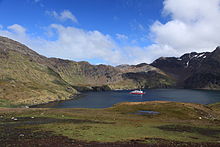
1205:Geographic Names Information System
1179:Geographic Names Information System
1153:Geographic Names Information System
1127:Geographic Names Information System
1098:Geographic Names Information System
1072:Geographic Names Information System
1046:Geographic Names Information System
1020:Geographic Names Information System
994:Geographic Names Information System
968:Geographic Names Information System
942:Geographic Names Information System
916:Geographic Names Information System
890:Geographic Names Information System
864:Geographic Names Information System
838:Geographic Names Information System
809:Geographic Names Information System
783:Geographic Names Information System
757:Geographic Names Information System
731:Geographic Names Information System
705:Geographic Names Information System
679:Geographic Names Information System
653:Geographic Names Information System
598:Geographic Names Information System
572:Geographic Names Information System
543:Geographic Names Information System
514:Geographic Names Information System
488:Geographic Names Information System
451:Geographic Names Information System
1232:from websites or documents of the
231:UK Antarctic Place-Names Committee
14:
1207:. United States Geological Survey
1181:. United States Geological Survey
1155:. United States Geological Survey
1129:. United States Geological Survey
1100:. United States Geological Survey
1074:. United States Geological Survey
1048:. United States Geological Survey
1022:. United States Geological Survey
996:. United States Geological Survey
970:. United States Geological Survey
944:. United States Geological Survey
918:. United States Geological Survey
892:. United States Geological Survey
866:. United States Geological Survey
840:. United States Geological Survey
811:. United States Geological Survey
785:. United States Geological Survey
759:. United States Geological Survey
733:. United States Geological Survey
707:. United States Geological Survey
681:. United States Geological Survey
655:. United States Geological Survey
600:. United States Geological Survey
574:. United States Geological Survey
545:. United States Geological Survey
516:. United States Geological Survey
490:. United States Geological Survey
1284:
1228: This article incorporates
1223:
376:George III of the United Kingdom
333:, a member of the survey party.
76:
69:
57:
38:
31:
24:
1234:United States Geological Survey
456:United States Geological Survey
1393:Settlements / Whaling stations
1:
303:, meaning "good hollow" in
161:, who, assisted by Captain
130:forming the east margin of
1837:
1816:Headlands of South Georgia
184:Northeast coast to Godthul
1384:Invasion of South Georgia
1299:
239:British Antarctic Survey
233:(UK-APC) in 1988, after
195:Discovery Investigations
1821:Subantarctic peninsulas
1347:List of South Georgians
1545:South Sandwich Islands
1230:public domain material
403:on the north coast of
363:
341:into this part of the
260:
1454:South Georgia islands
351:
251:
241:Station Commander at
1526:South Georgia Island
1445:Corbeta Uruguay base
1369:South Georgia Museum
1352:Operation "Paraquet"
270:South Georgia Survey
229:, it was renamed by
136:South Georgia Island
1506:Pickersgill Islands
1435:Prince Olav Harbour
539:"Right Whale Rocks"
374:, who named it for
206:Henry Percy Douglas
132:Cumberland East Bay
110: /
1770:Thatcher Peninsula
1501:Kupriyanov Islands
364:
261:
223:Three Lakes Valley
1803:
1802:
1657:
1656:
1625:
1624:
1599:Traversay Islands
1593:
1592:
1572:Candlemas Islands
1420:King Edward Point
1332:Foreign relations
1303:King Edward Point
1016:"Reindeer Valley"
446:"Barff Peninsula"
417:, a three-masted
313:Szielasko Ice Cap
235:Stephen J. Martin
215:British Admiralty
178:British Admiralty
114:54.317°S 36.300°W
1828:
1730:Mount Cunningham
1627:
1595:
1568:
1294:
1290:
1288:
1287:
1276:
1269:
1262:
1253:
1227:
1226:
1217:
1216:
1214:
1212:
1197:
1191:
1190:
1188:
1186:
1171:
1165:
1164:
1162:
1160:
1145:
1139:
1138:
1136:
1134:
1123:"Johannsen Loch"
1119:
1110:
1109:
1107:
1105:
1090:
1084:
1083:
1081:
1079:
1064:
1058:
1057:
1055:
1053:
1038:
1032:
1031:
1029:
1027:
1012:
1006:
1005:
1003:
1001:
986:
980:
979:
977:
975:
960:
954:
953:
951:
949:
934:
928:
927:
925:
923:
908:
902:
901:
899:
897:
882:
876:
875:
873:
871:
856:
850:
849:
847:
845:
830:
821:
820:
818:
816:
801:
795:
794:
792:
790:
775:
769:
768:
766:
764:
753:"Skrap Skerries"
749:
743:
742:
740:
738:
723:
717:
716:
714:
712:
697:
691:
690:
688:
686:
671:
665:
664:
662:
660:
645:
639:
638:
633:
631:
616:
610:
609:
607:
605:
590:
584:
583:
581:
579:
568:"Merton Passage"
564:
555:
554:
552:
550:
535:
526:
525:
523:
521:
506:
500:
499:
497:
495:
480:
471:
470:
468:
466:
442:
296:South of Godthul
286:Walter Hume Long
282:Harald Horntvedt
125:
124:
122:
121:
120:
119:-54.317; -36.300
115:
111:
108:
107:
106:
103:
86:
80:
79:
73:
66:
65:Barff Peninsular
61:
60:
54:
49:
42:
41:
35:
28:
1836:
1835:
1831:
1830:
1829:
1827:
1826:
1825:
1806:
1805:
1804:
1799:
1755:Salisbury Plain
1705:Fortuna Glacier
1700:Barff Peninsula
1695:Allardyce Range
1678:
1669:Protector Shoal
1653:
1621:
1589:
1566:
1540:
1531:Welcome Islands
1461:Annenkov Island
1449:
1388:
1357:Public holidays
1305:
1295:
1285:
1283:
1282:
1280:
1242:
1224:
1221:
1220:
1210:
1208:
1199:
1198:
1194:
1184:
1182:
1173:
1172:
1168:
1158:
1156:
1149:"Ocean Harbour"
1147:
1146:
1142:
1132:
1130:
1121:
1120:
1113:
1103:
1101:
1092:
1091:
1087:
1077:
1075:
1068:"Horseshoe Bay"
1066:
1065:
1061:
1051:
1049:
1040:
1039:
1035:
1025:
1023:
1014:
1013:
1009:
999:
997:
988:
987:
983:
973:
971:
962:
961:
957:
947:
945:
936:
935:
931:
921:
919:
912:"O'Connor Peak"
910:
909:
905:
895:
893:
884:
883:
879:
869:
867:
858:
857:
853:
843:
841:
834:"Cobblers Cove"
832:
831:
824:
814:
812:
803:
802:
798:
788:
786:
779:"Martin Valley"
777:
776:
772:
762:
760:
751:
750:
746:
736:
734:
727:"Rookery Point"
725:
724:
720:
710:
708:
699:
698:
694:
684:
682:
673:
672:
668:
658:
656:
647:
646:
642:
629:
627:
618:
617:
613:
603:
601:
592:
591:
587:
577:
575:
566:
565:
558:
548:
546:
537:
536:
529:
519:
517:
508:
507:
503:
493:
491:
482:
481:
474:
464:
462:
444:
443:
436:
431:
382:Fridtjof Nansen
298:
274:Skomaker Hullet
186:
171:
118:
116:
112:
109:
104:
101:
99:
97:
96:
93:Barff Peninsula
90:
89:
88:
87:
83:
81:
77:
74:
67:
64:
62:
58:
55:
52:
50:
47:
45:
43:
39:
36:
29:
17:
12:
11:
5:
1834:
1832:
1824:
1823:
1818:
1808:
1807:
1801:
1800:
1798:
1797:
1792:
1790:Possession Bay
1787:
1785:Cumberland Bay
1782:
1777:
1772:
1767:
1765:Southern Thule
1762:
1760:Salvesen Range
1757:
1752:
1750:Peggotty Bluff
1747:
1742:
1737:
1732:
1727:
1722:
1717:
1715:Larsen Harbour
1712:
1707:
1702:
1697:
1692:
1690:Admiralty Peak
1686:
1684:
1680:
1679:
1677:
1676:
1671:
1665:
1663:
1659:
1658:
1655:
1654:
1652:
1651:
1646:
1641:
1639:Bellingshausen
1635:
1633:
1631:Southern Thule
1623:
1622:
1620:
1619:
1614:
1609:
1603:
1601:
1591:
1590:
1588:
1587:
1582:
1576:
1574:
1565:
1564:
1559:
1554:
1548:
1546:
1542:
1541:
1539:
1538:
1536:Willis Islands
1533:
1528:
1523:
1518:
1513:
1508:
1503:
1498:
1493:
1488:
1483:
1478:
1473:
1468:
1463:
1457:
1455:
1451:
1450:
1448:
1447:
1442:
1437:
1432:
1427:
1422:
1417:
1412:
1407:
1402:
1396:
1394:
1390:
1389:
1387:
1386:
1381:
1376:
1371:
1366:
1365:
1364:
1354:
1349:
1344:
1339:
1334:
1329:
1324:
1319:
1313:
1311:
1307:
1306:
1300:
1297:
1296:
1281:
1279:
1278:
1271:
1264:
1256:
1250:
1249:
1241:
1240:External links
1238:
1219:
1218:
1201:"Tijuca Point"
1192:
1166:
1140:
1111:
1085:
1059:
1033:
1007:
981:
964:"Briggs Point"
955:
929:
903:
877:
851:
822:
796:
770:
744:
718:
692:
666:
640:
611:
585:
556:
527:
501:
472:
433:
432:
430:
427:
297:
294:
219:Skrap Skerries
185:
182:
170:
169:Named features
167:
140:Sörling Valley
82:
75:
68:
63:
56:
51:
44:
37:
30:
23:
22:
21:
20:
15:
13:
10:
9:
6:
4:
3:
2:
1833:
1822:
1819:
1817:
1814:
1813:
1811:
1796:
1793:
1791:
1788:
1786:
1783:
1781:
1780:Stromness Bay
1778:
1776:
1773:
1771:
1768:
1766:
1763:
1761:
1758:
1756:
1753:
1751:
1748:
1746:
1743:
1741:
1738:
1736:
1733:
1731:
1728:
1726:
1725:Mount Belinda
1723:
1721:
1718:
1716:
1713:
1711:
1708:
1706:
1703:
1701:
1698:
1696:
1693:
1691:
1688:
1687:
1685:
1681:
1675:
1672:
1670:
1667:
1666:
1664:
1660:
1650:
1647:
1645:
1642:
1640:
1637:
1636:
1634:
1632:
1628:
1618:
1615:
1613:
1610:
1608:
1605:
1604:
1602:
1600:
1596:
1586:
1583:
1581:
1578:
1577:
1575:
1573:
1569:
1563:
1560:
1558:
1555:
1553:
1550:
1549:
1547:
1543:
1537:
1534:
1532:
1529:
1527:
1524:
1522:
1519:
1517:
1516:Saddle Island
1514:
1512:
1509:
1507:
1504:
1502:
1499:
1497:
1494:
1492:
1489:
1487:
1486:Cooper Island
1484:
1482:
1479:
1477:
1474:
1472:
1469:
1467:
1464:
1462:
1459:
1458:
1456:
1452:
1446:
1443:
1441:
1438:
1436:
1433:
1431:
1430:Ocean Harbour
1428:
1426:
1425:Leith Harbour
1423:
1421:
1418:
1416:
1413:
1411:
1408:
1406:
1403:
1401:
1398:
1397:
1395:
1391:
1385:
1382:
1380:
1377:
1375:
1372:
1370:
1367:
1363:
1362:Toothfish Day
1360:
1359:
1358:
1355:
1353:
1350:
1348:
1345:
1343:
1340:
1338:
1335:
1333:
1330:
1328:
1325:
1323:
1320:
1318:
1315:
1314:
1312:
1308:
1304:
1298:
1293:
1277:
1272:
1270:
1265:
1263:
1258:
1257:
1254:
1247:
1244:
1243:
1239:
1237:
1235:
1231:
1206:
1202:
1196:
1193:
1180:
1176:
1175:"Penguin Bay"
1170:
1167:
1154:
1150:
1144:
1141:
1128:
1124:
1118:
1116:
1112:
1099:
1095:
1094:"Nansen Reef"
1089:
1086:
1073:
1069:
1063:
1060:
1047:
1043:
1042:"Cape George"
1037:
1034:
1021:
1017:
1011:
1008:
995:
991:
990:"Alsford Bay"
985:
982:
969:
965:
959:
956:
943:
939:
933:
930:
917:
913:
907:
904:
891:
887:
881:
878:
865:
861:
860:"Babe Island"
855:
852:
839:
835:
829:
827:
823:
810:
806:
800:
797:
784:
780:
774:
771:
758:
754:
748:
745:
732:
728:
722:
719:
706:
702:
701:"Rookery Bay"
696:
693:
680:
676:
675:"Lucas Point"
670:
667:
654:
650:
644:
641:
637:
625:
621:
615:
612:
599:
595:
589:
586:
573:
569:
563:
561:
557:
544:
540:
534:
532:
528:
515:
511:
505:
502:
489:
485:
484:"Barff Point"
479:
477:
473:
461:
457:
453:
452:
447:
441:
439:
435:
428:
426:
424:
420:
416:
415:
410:
406:
405:South Georgia
402:
397:
395:
394:Ocean Harbour
391:
386:
384:
383:
377:
373:
369:
368:second voyage
361:
360:Ocean Harbour
357:
356:
352:The wreck of
350:
346:
344:
340:
334:
332:
331:
325:
322:
318:
314:
310:
306:
302:
295:
293:
291:
290:O'Connor Peak
287:
283:
279:
275:
271:
267:
259:
255:
250:
246:
244:
240:
236:
232:
228:
224:
220:
216:
211:
207:
202:
200:
196:
192:
183:
181:
179:
174:
168:
166:
164:
160:
159:
153:
149:
145:
141:
137:
133:
129:
123:
94:
85:
72:
53:SOUTH GEORGIA
34:
27:
19:
1775:Bay of Isles
1710:Gold Harbour
1699:
1674:Kemp Caldera
1511:Prion Island
1491:Grass Island
1481:Clerke Rocks
1322:Commissioner
1317:Coat of arms
1222:
1209:. Retrieved
1204:
1195:
1183:. Retrieved
1178:
1169:
1157:. Retrieved
1152:
1143:
1131:. Retrieved
1126:
1102:. Retrieved
1097:
1088:
1076:. Retrieved
1071:
1062:
1050:. Retrieved
1045:
1036:
1024:. Retrieved
1019:
1010:
998:. Retrieved
993:
984:
972:. Retrieved
967:
958:
946:. Retrieved
941:
932:
920:. Retrieved
915:
906:
894:. Retrieved
889:
886:"Long Point"
880:
868:. Retrieved
863:
854:
842:. Retrieved
837:
813:. Retrieved
808:
805:"Skua Point"
799:
787:. Retrieved
782:
773:
761:. Retrieved
756:
747:
735:. Retrieved
730:
721:
709:. Retrieved
704:
695:
683:. Retrieved
678:
669:
657:. Retrieved
652:
649:"Mills Peak"
643:
635:
628:. Retrieved
614:
602:. Retrieved
597:
594:"Alert Rock"
588:
576:. Retrieved
571:
547:. Retrieved
542:
518:. Retrieved
513:
510:"Cave Point"
504:
492:. Retrieved
487:
463:. Retrieved
449:
413:
398:
387:
381:
365:
354:
335:
329:
324:W.B. Alsford
299:
273:
262:
253:
227:Signy Island
203:
198:
190:
187:
175:
172:
157:
92:
91:
18:
1795:Busen Point
1740:Mount Roots
1735:Mount Paget
1720:Mount Baume
1585:Vindication
1476:Black Rocks
1466:Bird Island
1400:Bird Island
1379:Sovereignty
370:of Captain
317:A.C. Briggs
217:chart. The
163:C.A. Larsen
150:Lieutenant
117: /
1810:Categories
1617:Zavodovski
1521:Shag Rocks
1471:Black Rock
622:(Report).
429:References
372:James Cook
254:Expedition
210:Mills Peak
152:A.D. Barff
148:Royal Navy
144:James Cook
1745:Orca Peak
1683:Landmarks
1662:Seamounts
1580:Candlemas
1496:Grassholm
1440:Stromness
1405:Grytviken
1342:Languages
1301:Capital:
938:"Godthul"
425:in 1866.
421:built at
401:Hound Bay
345:in 1909.
330:Discovery
328:RRS
305:Norwegian
243:Grytviken
156:HMS
128:peninsula
1562:Saunders
409:penguins
380:SS
339:reindeer
1612:Visokoi
1557:Montagu
1552:Bristol
1410:Godthul
1337:History
1310:General
626:. 91228
362:in 2014
307:, is a
301:Godthul
278:cobbler
266:The Cut
258:Godthul
180:chart.
126:) is a
105:36°18′W
102:54°19′S
48:30miles
1607:Leskov
1415:Husvik
1289:
1211:13 May
1185:13 May
1159:13 May
1133:13 May
1104:13 May
1078:13 May
1052:13 May
1026:18 May
1000:13 May
974:13 May
948:13 May
922:13 May
896:13 May
870:13 May
844:13 May
815:13 May
789:13 May
763:13 May
737:13 May
711:13 May
685:13 May
659:13 May
630:13 May
604:13 May
578:13 May
549:13 May
520:13 May
494:13 May
465:13 May
423:Nantes
419:barque
414:Tijuca
355:Bayard
343:island
321:Stoker
191:Sappho
158:Sappho
1649:Thule
326:, of
199:Alert
1644:Cook
1327:Flag
1213:2019
1187:2019
1161:2019
1135:2019
1106:2019
1080:2019
1054:2019
1028:2019
1002:2019
976:2019
950:2019
924:2019
898:2019
872:2019
846:2019
817:2019
791:2019
765:2019
739:2019
713:2019
687:2019
661:2019
632:2019
606:2019
580:2019
551:2019
522:2019
496:2019
467:2019
390:cove
46:50km
1374:.gs
358:in
309:bay
256:at
252:MS
225:on
154:of
1812::
1236:.
1203:.
1177:.
1151:.
1125:.
1114:^
1096:.
1070:.
1044:.
1018:.
992:.
966:.
940:.
914:.
888:.
862:.
836:.
825:^
807:.
781:.
755:.
729:.
703:.
677:.
651:.
634:.
596:.
570:.
559:^
541:.
530:^
512:.
486:.
475:^
458:,
454:.
448:.
437:^
288:.
245:.
237:,
134:,
1275:e
1268:t
1261:v
1215:.
1189:.
1163:.
1137:.
1108:.
1082:.
1056:.
1030:.
1004:.
978:.
952:.
926:.
900:.
874:.
848:.
819:.
793:.
767:.
741:.
715:.
689:.
663:.
608:.
582:.
553:.
524:.
498:.
469:.
95:(
Text is available under the Creative Commons Attribution-ShareAlike License. Additional terms may apply.