54:
84:
281:
40:
91:
61:
299:. In 1908, the Central Colorado Power Company began construction of Barker Dam to provide electricity to nearby mining communities and the city of Denver. Completed in 1910, the dam and Barker Reservoir were named for the owner of the land, Mrs.
322:
In 2001 the city of
Boulder purchased the reservoir, dam, and associated facilities. The city operates the reservoir primarily for municipal water supply and secondarily to generate hydroelectric power. An aqueduct with an
422:
456:
446:
327:
just below the dam supplies water to
Kossler Reservoir. There is then a 1828 foot drop to a hydroelectric plant near the base of Boulder Canyon, several miles downstream.
138:
379:
53:
83:
303:. Mrs. Barker refused to sell the land to the utility but was eventually forced to do so through a process similar to the contemporary legal procedure of
426:
406:
344:"Report on Barker Reservoir Boulder County Colorado EPA Region VIII Working Paper No. 765". US Environmental Protection Agency. June 1977.
451:
383:
274:
116:
349:
300:
266:
270:
280:
402:
312:
296:
362:
304:
182:
440:
292:
170:
124:
17:
39:
239:
153:
140:
262:
175:
295:
power generating facility, and its reservoir provides water to the city of
316:
308:
120:
324:
279:
311:
and other materials along a specially constructed spur of the
248:
238:
220:
212:
204:
196:
192:
181:
169:
130:
112:
32:
319:, which went bankrupt and was broken up in 1919.
131:
8:
457:Bodies of water of Boulder County, Colorado
447:Protected areas of Boulder County, Colorado
382:. City of Boulder, Colorado. Archived from
29:
374:
372:
90:
60:
336:
358:
347:
307:. The dam was constructed by hauling
7:
27:Reservoir in Colorado, United States
200:1.70 km (0.66 sq mi)
25:
399:The Switzerland Trail of America
89:
82:
59:
52:
38:
423:"City of Boulder Water Sources"
291:provides water to a downstream
247:
237:
219:
211:
203:
195:
1:
380:"History of Barker Reservoir"
234: m (11,500 acre⋅ft)
111:
103:Show map of the United States
252:8,183 ft (2,494 m)
473:
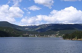
269:located near the town of
216:36.6 m (120 ft)
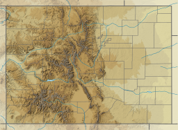
46:
37:
397:Crossen, Forest (1978).
208:8.3 m (27 ft)
452:Reservoirs in Colorado
357:Cite journal requires
285:
154:39.96528°N 105.49278°W
301:Hannah Connell Barker
283:
18:Barker Dam (Colorado)
267:Colorado Front Range
159:39.96528; -105.49278
73:Show map of Colorado
271:Nederland, Colorado
240:Residence time
150: /
401:. Robinson Press.
286:
261:is a water supply
408:978-0-913730-24-9
313:Switzerland Trail
297:Boulder, Colorado
256:
255:
249:Surface elevation
16:(Redirected from
464:
431:
430:
425:. Archived from
419:
413:
412:
394:
388:
387:
376:
367:
366:
360:
355:
353:
345:
341:
273:in southwestern
259:Barker Reservoir
230:
229:
165:
164:
162:
161:
160:
155:
151:
148:
147:
146:
143:
133:
104:
97:Barker Reservoir
93:
92:
86:
74:
67:Barker Reservoir
63:
62:
56:
42:
33:Barker Reservoir
30:
21:
472:
471:
467:
466:
465:
463:
462:
461:
437:
436:
435:
434:
421:
420:
416:
409:
396:
395:
391:
378:
377:
370:
356:
346:
343:
342:
338:
333:
227:
225:
185: countries
158:
156:
152:
149:
144:
141:
139:
137:
136:
108:
107:
106:
105:
102:
101:
100:
99:
98:
94:
77:
76:
75:
72:
71:
70:
69:
68:
64:
28:
23:
22:
15:
12:
11:
5:
470:
468:
460:
459:
454:
449:
439:
438:
433:
432:
429:on 2012-06-07.
414:
407:
389:
386:on 2007-10-04.
368:
359:|journal=
335:
334:
332:
329:
305:eminent domain
275:Boulder County
254:
253:
250:
246:
245:
242:
236:
235:
222:
218:
217:
214:
210:
209:
206:
202:
201:
198:
194:
193:
190:
189:
186:
179:
178:
173:
167:
166:
134:
128:
127:
117:Boulder County
114:
110:
109:
96:
95:
88:
87:
81:
80:
79:
78:
66:
65:
58:
57:
51:
50:
49:
48:
47:
44:
43:
35:
34:
26:
24:
14:
13:
10:
9:
6:
4:
3:
2:
469:
458:
455:
453:
450:
448:
445:
444:
442:
428:
424:
418:
415:
410:
404:
400:
393:
390:
385:
381:
375:
373:
369:
364:
351:
340:
337:
330:
328:
326:
320:
318:
315:narrow-gauge
314:
310:
306:
302:
298:
294:
293:hydroelectric
290:
282:
278:
276:
272:
268:
264:
260:
251:
243:
241:
233:
223:
215:
207:
205:Average depth
199:
191:
188:United States
187:
184:
180:
177:
174:
172:
168:
163:
135:
129:
126:
125:United States
122:
118:
115:
85:
55:
45:
41:
36:
31:
19:
427:the original
417:
398:
392:
384:the original
350:cite journal
339:
321:
288:
287:
258:
257:
231:
221:Water volume
197:Surface area
157: /
145:105°29′34″W
132:Coordinates
441:Categories
331:References
289:Barker Dam
284:Barker Dam
213:Max. depth
142:39°57′55″N
263:reservoir
176:reservoir
317:railroad
309:concrete
244:104 days
121:Colorado
113:Location
265:in the
405:
224:14.185
325:inlet
183:Basin
403:ISBN
363:help
171:Type
443::
371:^
354::
352:}}
348:{{
277:.
228:10
123:,
119:,
411:.
365:)
361:(
232:^
226:×
20:)
Text is available under the Creative Commons Attribution-ShareAlike License. Additional terms may apply.