45:
29:
52:
564:
The
Batchawana River Provincial Park protects certain sections of the river and its banks, as well as some adjacent forests. It was established in 2004 and is meant for canoeing and fishing. Features in the park include wide meanders, numerous rapids, islands, shifting stream channels and a 13
366:, meaning "current at the strait" or "narrows and swift water there", and refers to the turbulent or bubbling waters flowing between Batchawana Island and Sand Point (directly east of the Batchawana River's mouth).
495:
44:
565:
kilometres (8.1 mi) long canyon. The forests include yellow birch, white pine and eastern hemlock, that at the northern end of its range.
930:
750:
935:
115:
93:
925:
657:
632:
255:
885:
477:
451:
389:
174:
622:
400:
920:
866:
813:
602:
352:
336:
160:
128:
871:
818:
607:
332:
241:
123:
382:
782:
577:
393:
404:
108:
861:
808:
597:
378:
675:"Historic Forts and Trading Posts of the French regime and of the English Fur Trading Companies"
756:
746:
653:
628:
742:
735:
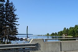
392:, with a large sandy beach, is located just west of the river's mouth on Batchawana Bay. The
890:
359:
72:
344:
311:
225:
895:
914:
700:
554:
481:
348:
229:
835:
370:
220:
28:
674:
568:
It is a non-operating park, meaning that there are no facilities or services.
886:"Toporama - Topographic Map Shees 41K15, 41K16, 41N1, 41N2, 41N8, 41O4, 41O5"
510:
497:
270:
257:
189:
176:
760:
374:
388:
Batchawana River
Provincial Park encompasses portions of the river, and
412:
340:
98:
408:
328:
385:
appears to have operated a post there as well circa 1868-1869.
714:(207). National Historic Parks and Sites Branch, Parks Canada
733:
Chisholm, Barbara; Gutsche, Andrea; Floren, Russell (1998).
59:
Location of the mouth of the
Batchawana River in Ontario
403:, so named because fur traders travelling east from
550:
542:
534:
526:
489:
470:
396:crosses the river at the settlement of Batchewana.
309:
304:
296:
286:
247:
235:
219:
205:
166:
154:
146:
137:
114:
104:
92:
84:
79:
67:
21:
734:
373:was established near the mouth of the river for
33:Mouth of the Batchawana River at Batchawana Bay
8:
701:"The Fur Trade in Eastern Canada Until 1870"
624:Hidden Ontario: secrets from Ontario's past
894:. Natural Resources Canada. Archived from
783:"HBCA Post Records By Number - Batchewana"
467:
358:The name "Batchawana" is derived from the
652:(1st ed.). : A & M. p. 62.
51:
627:. Toronto: Dundurn Press. p. 106.
589:
737:Superior: Under the Shadow of the Gods
18:
530:2,684 ha (10.36 sq mi)
377:around 1817 or 1819 by clerks of the
7:
830:
828:
809:"Batchawana River Provincial Park"
14:
741:. Toronto: Lynx Images. pp.
471:Batchawana River Provincial Park
462:Batchawana River Provincial Park
50:
43:
27:
781:Hudson's Bay Company Archives.
541:
433:Little Batchawana River (right)
390:Batchawana Bay Provincial Park
249: • coordinates
168: • coordinates
75:meaning "swift waters/current"
1:
343:, Canada, which empties into
138:Physical characteristics
931:Tributaries of Lake Superior
867:Geographical Names Data Base
814:Geographical Names Data Base
603:Geographical Names Data Base
288: • elevation
207: • elevation
399:North of Batchawana Bay is
237: • location
156: • location
952:
936:Rivers of Sudbury District
211:487 m (1,598 ft)
926:Rivers of Algoma District
475:
353:Sault Ste. Marie, Ontario
215:
142:
38:
26:
872:Natural Resources Canada
819:Natural Resources Canada
708:Manuscript Report Number
648:Franklin, Dixie (1991).
608:Natural Resources Canada
292:180 m (590 ft)
16:River in Ontario, Canada
300:95 km (59 mi)
789:. Province of Manitoba
699:Anick, Norman (1976).
650:Faces of Lake Superior
578:List of Ontario rivers
439:St. Clair Creek (left)
394:Algoma Central Railway
621:Boyle, Terry (2011).
511:47.13389°N 84.41500°W
436:Mongoose Creek (left)
271:46.93028°N 84.52833°W
190:47.24333°N 83.66194°W
840:www.ontarioparks.com
448:Emerson Creek (left)
430:Griffin Creek (left)
427:Norberg Creek (left)
383:Hudson's Bay Company
109:Northeastern Ontario
551:Governing body
516:47.13389; -84.41500
507: /
442:Alder Creek (right)
424:Kerwin Creek (left)
305:Basin features
276:46.93028; -84.52833
267: /
195:47.24333; -83.66194
186: /
862:"Batchawana River"
836:"Batchawana River"
598:"Batchawana River"
457:Toll Creek (right)
445:Quinn River (left)
379:North West Company
752:978-0-9698427-7-4
560:
559:
321:
320:
317:Great Lakes Basin
943:
921:IUCN Category II
906:
904:
903:
881:
879:
878:
852:
851:
849:
847:
832:
823:
822:
805:
799:
798:
796:
794:
778:
772:
771:
769:
767:
740:
730:
724:
723:
721:
719:
705:
696:
690:
689:
687:
685:
673:Ernest Voorhis.
670:
664:
663:
645:
639:
638:
618:
612:
611:
594:
522:
521:
519:
518:
517:
512:
508:
505:
504:
503:
500:
468:
407:had only enough
325:Batchawana River
314:
282:
281:
279:
278:
277:
272:
268:
265:
264:
263:
260:
208:
201:
200:
198:
197:
196:
191:
187:
184:
183:
182:
179:
169:
161:Sudbury District
157:
54:
53:
47:
31:
22:Batchawana River
19:
951:
950:
946:
945:
944:
942:
941:
940:
911:
910:
909:
901:
899:
891:Atlas of Canada
884:
876:
874:
860:
856:
855:
845:
843:
842:. Ontario Parks
834:
833:
826:
807:
806:
802:
792:
790:
780:
779:
775:
765:
763:
753:
732:
731:
727:
717:
715:
703:
698:
697:
693:
683:
681:
672:
671:
667:
660:
647:
646:
642:
635:
620:
619:
615:
596:
595:
591:
586:
574:
562:
561:
515:
513:
509:
506:
501:
498:
496:
494:
493:
485:
464:
421:
310:
289:
275:
273:
269:
266:
261:
258:
256:
254:
253:
250:
242:Algoma District
238:
206:
194:
192:
188:
185:
180:
177:
175:
173:
172:
167:
155:
133:
63:
62:
61:
60:
57:
56:
55:
34:
17:
12:
11:
5:
949:
947:
939:
938:
933:
928:
923:
913:
912:
908:
907:
882:
857:
854:
853:
824:
800:
773:
751:
725:
691:
665:
658:
640:
633:
613:
588:
587:
585:
582:
581:
580:
573:
570:
558:
557:
552:
548:
547:
544:
540:
539:
536:
532:
531:
528:
524:
523:
491:
487:
486:
476:
473:
472:
466:
465:
463:
460:
459:
458:
455:
449:
446:
443:
440:
437:
434:
431:
428:
425:
420:
417:
345:Batchawana Bay
319:
318:
315:
307:
306:
302:
301:
298:
294:
293:
290:
287:
284:
283:
251:
248:
245:
244:
239:
236:
233:
232:
226:Batchawana Bay
223:
217:
216:
213:
212:
209:
203:
202:
170:
164:
163:
158:
152:
151:
148:
144:
143:
140:
139:
135:
134:
132:
131:
126:
120:
118:
112:
111:
106:
102:
101:
96:
90:
89:
86:
82:
81:
77:
76:
69:
65:
64:
58:
49:
48:
42:
41:
40:
39:
36:
35:
32:
24:
23:
15:
13:
10:
9:
6:
4:
3:
2:
948:
937:
934:
932:
929:
927:
924:
922:
919:
918:
916:
898:on 2010-08-31
897:
893:
892:
887:
883:
873:
869:
868:
863:
859:
858:
841:
837:
831:
829:
825:
820:
816:
815:
810:
804:
801:
788:
787:www.gov.mb.ca
784:
777:
774:
762:
758:
754:
748:
744:
739:
738:
729:
726:
713:
709:
702:
695:
692:
680:
679:www.enhaut.ca
676:
669:
666:
661:
659:9781878005144
655:
651:
644:
641:
636:
634:9781554889563
630:
626:
625:
617:
614:
609:
605:
604:
599:
593:
590:
583:
579:
576:
575:
571:
569:
566:
556:
555:Ontario Parks
553:
549:
545:
537:
533:
529:
525:
520:
492:
488:
483:
482:national park
479:
478:IUCN category
474:
469:
461:
456:
453:
450:
447:
444:
441:
438:
435:
432:
429:
426:
423:
422:
418:
416:
414:
411:left to make
410:
406:
402:
397:
395:
391:
386:
384:
380:
376:
372:
367:
365:
364:obatchiwanang
361:
356:
354:
350:
349:Lake Superior
346:
342:
339:Districts of
338:
334:
330:
326:
316:
313:
308:
303:
299:
295:
291:
285:
280:
252:
246:
243:
240:
234:
231:
230:Lake Superior
227:
224:
222:
218:
214:
210:
204:
199:
171:
165:
162:
159:
153:
149:
145:
141:
136:
130:
127:
125:
122:
121:
119:
117:
113:
110:
107:
103:
100:
97:
95:
91:
87:
83:
78:
74:
70:
66:
46:
37:
30:
25:
20:
900:. Retrieved
896:the original
889:
875:. Retrieved
865:
846:10 September
844:. Retrieved
839:
812:
803:
793:13 September
791:. Retrieved
786:
776:
766:13 September
764:. Retrieved
736:
728:
718:13 September
716:. Retrieved
711:
707:
694:
684:13 September
682:. Retrieved
678:
668:
649:
643:
623:
616:
601:
592:
567:
563:
405:Fort William
398:
387:
371:trading post
368:
363:
357:
324:
322:
312:River system
150:Unnamed lake
543:Established
535:Designation
514: /
490:Coordinates
452:Percy Creek
419:Tributaries
401:Pancake Bay
375:fur trading
274: /
193: /
915:Categories
902:2010-07-01
877:2010-07-01
584:References
502:84°24′54″W
499:47°08′02″N
262:84°31′42″W
259:46°55′49″N
181:83°39′43″W
178:47°14′36″N
351:north of
116:Districts
71:From the
68:Etymology
761:39380117
572:See also
538:Waterway
413:pancakes
94:Province
80:Location
454:(right)
341:Ontario
337:Sudbury
129:Sudbury
99:Ontario
85:Country
759:
749:
656:
631:
381:. The
360:Ojibwe
333:Algoma
297:Length
147:Source
124:Algoma
105:Region
88:Canada
73:Ojibwe
743:28–29
704:(PDF)
409:flour
362:word
329:river
327:is a
221:Mouth
848:2021
795:2021
768:2021
757:OCLC
747:ISBN
720:2021
686:2021
654:ISBN
629:ISBN
546:2004
527:Area
480:II (
335:and
323:The
347:on
331:in
917::
888:.
870:.
864:.
838:.
827:^
817:.
811:.
785:.
755:.
745:.
710:.
706:.
677:.
606:.
600:.
415:.
369:A
355:.
228:,
905:.
880:.
850:.
821:.
797:.
770:.
722:.
712:I
688:.
662:.
637:.
610:.
484:)
Text is available under the Creative Commons Attribution-ShareAlike License. Additional terms may apply.