292:
65:
1052:
506:
498:
46:
490:
72:
1287:. He was particularly keen on scientific research and donated money to build a specialist Antarctic Library at the Museum. He also donated a large collection of Antarctic materials to the Museum, including some very old and rare Antarctic manuscripts. He remained interested in the collection and continued his sponsorship and donations over more than 30 years.
1951:
1806:
481:. A high snow-covered cape at the south side of Barne Inlet, the terminus of Byrd Glacier at the west side of the Ross Ice Shelf. Discovered by the BrNAE (1901-04) and named for William Waldegrave Palmer Selborne, Second Earl of Selborne, who entered the Cabinet as First Lord of the Admiralty in 1900. Not: Cape Selbourne, Cape Selhora.
436:
A high snow-covered cape at the north side of Barne Inlet, the terminus of Byrd
Glacier at the W side of the Ross Ice Shelf. Discovered by the BrNAE (1901-04) and named for Admiral of the Fleet, Lord Walter Kerr, one of the Sea Lords who lent his assistance to the expedition.
1043:. Glacier about 9 miles (14 km) long, flowing from the vicinity of Mount Hamilton northeastward to enter Byrd Glacier just east of Mount Tuatara. Named by US-ACAN for Cdr. J.H. Judith, USN, commanding officer of the Edisto during USN OpDFrz 1964.
636:
A steep tributary glacier just east of
Peckham Glacier, flowing from the south slopes of the Britannia Range into Byrd Glacier. Named by US-ACAN for Arthur L. DeVries, USARP biologist at McMurdo Station in the 1961-62 and 1963-64 summer seasons.
916:. Glacier about 10 miles (16 km) long, flowing into the south side of Byrd Glacier just west of Rundle Peaks. Named by the US-ACAN for Ronald Sefton, ionospheric physicist, a member of the Byrd Station winter parties of 1962 and 1964.
679:
and then southeastward to enter Byrd
Glacier just west of Sennet Glacier. Named by US-ACAN in association with nearby Byrd Glacier for the USS Yancey, cargo ship (Central Group of Task Force 68) of USN OpHjp, 1946-47, led by Admiral Byrd.
954:
A glacier 6 miles (9.7 km) long, flowing from the north side of the Kent
Plateau into the south side of Byrd Glacier. Named by US-ACAN for C.E. Twombley of the U.S. Weather Bureau, a member of the Little America V winter party, 1956.
878:. A glacier about 10 miles (16 km) long, flowing west-north-west to enter the south side of Byrd Glacier just north of Mount Fries. Named by US-ACAN for Edward J. Zeller, geologist at McMurdo Station, 1959-60 and 1960-61 seasons.
597:
into Byrd
Glacier. Named by US-ACAN for Verne E. Peckham, biologist, McMurdo Station winter party 1962, who with use of SCUBA gear made numerous dives under the sea ice of McMurdo Sound at Winter Quarters Bay and off Cape Evans.
391:
on the west side of the Ross Ice Shelf. Discovered by the BrNAE (1901-04) and named for Lt. Michael Barne, RN, a member of the expedition, who with Sub-Lt. George F.A. Mulock, RN, mapped the coastline this far south in 1903.
1955:
1810:
1453:. A large group of nunataks near the polar plateau, lying 10 miles (16 km) northeast of All-Blacks Nunataks at the east side of the Byrd Névé. Named by the NZGSAE (1960-61) for the well known Australian rugby team.
1405:
A group of about a dozen black nunataks at the southeast side of the Byrd Neve. This scattered group lies 4 miles (6.4 km) southeast of All-Blacks
Nunataks and 15 miles (24 km) southwest of
236:) is a major glacier in Antarctica, about 136 km (85 mi) long and 24 km (15 mi) wide. It drains an extensive area of the Antarctic plateau, and flows eastward to discharge into the
820:, and flowing southeast to Merrick Glacier. Named by the US-ACAN in association with Byrd Glacier and Merrick Glacier, after Captain Joseph J. Hourihan, United States Navy, captain of USS
1329:, Britannia Range. Discovered by the Darwin Glacier Party of the CTAE (1956-58). Named by the NZ-APC for J. Bates, a member of CTAE who accompanied Sir Edmund Hillary to the South Pole.
722:
to the Byrd
Glacier. Named by US-ACAN, ACAN, in association with Byrd Glacier, for the USS Sennet, submarine (Central Group 'of Task Force 68) of USN OpHjp, 1946-47, led by Admiral Byrd.
1367:. The smallest and northernmost of the Bates Nunataks at the west end of the Britannia Range. So named because of its small size in relation to the two southern nunataks in the group.
1221:
flowing north west between All-Blacks
Nunataks and Wallabies Nunataks. It was named in association with the adjacent All-Blacks and Wallabies Nunataks, and specifically named after the
1987:
1005:; he conducted Antarctic glaciological investigations for over 30 years, 1960–95, including determinations of surface velocities and elevations on Byrd Glacier.
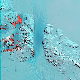
108:
1940:
1919:
1898:
1877:
1856:
1835:
64:
1814:
199:
1980:
1931:
1910:
1889:
1868:
1847:
1826:
1234:
1926:
1905:
1884:
1863:
1842:
1821:
2025:
2015:
1160:
2020:
1973:
1959:
1936:
1915:
1894:
1873:
1852:
1831:
1284:
1996:
997:
that flows north between the Rundle Peaks and
Mandarich Massif into Byrd Glacier. It was named after Henry H. Brecher of the
555:. Named by the US-ACAN for Réne O. Ramseier, glaciologist at McMurdo and´South Pole Stations, 1960-61 and 1961-62 seasons.
760:. A steep tributary glacier just east of Sennet Glacier, descending southwestward to enter Byrd Glacier at the west end of
1339:
249:
101:
551:. Steep cirque-type glacier, 5 miles (8.0 km) long, flowing southwest to enter Byrd Glacier immediately east of
788:
998:
1772:
1425:
1377:
1297:
1247:
1189:
1077:
1015:
965:
926:
888:
850:
732:
690:
647:
608:
565:
523:
453:
408:
355:
1115:
291:
304:
513:
Tributaries entering the left (north) side of the glacier from the
Brittania Range are, from west to east:
1002:
1051:
383:
A reentrant about 17 miles (27 km) wide occupied by the lower part of Byrd Glacier, lying between
1105:
An immense névé at the head of Byrd Glacier. Named by the NZ-APC in association with Byrd Glacier.
1276:
1275:. A glacier flowing west north west between All-Blacks Nunataks and Wilhoite Nunataks, west of the
994:
331:
253:
505:
497:
1418:
825:
769:
326:
280:
1148:
269:
321:
781:
676:
594:
272:(assuming ice does not count as water), reaching 2,780 metres (9,120 feet) below sea level.
1163:. He spent five field seasons (during 1984–93) in Antarctica working on mantle and crustal
1280:
1172:
829:
276:
94:
1159:
at the northeast. It was named in honor of John A. Gamble, a geological scientist at the
1156:
237:
176:
1325:. Three isolated nunataks in the névé of Byrd Glacier, 18 miles (29 km) west of
1175:, including the West Antarctica Volcano Expedition (1989–92), and on the volcanoes in
2009:
1222:
1176:
1152:
719:
718:. A precipitous glacier between Yancey and Merrick Glaciers, flowing southward from
552:
446:
388:
265:
1409:
of the Churchill Mountains. Charted and descriptively named by the NZGSAE, 1960-61.
45:
1788:
1326:
761:
1406:
1226:
1168:
489:
348:
257:
268:
to the south. The valley below the glacier used to be recognised as one of the
1230:
817:
80:
17:
1440:
1427:
1392:
1379:
1354:
1341:
1312:
1299:
1262:
1249:
1204:
1191:
1130:
1117:
1092:
1079:
1060:
1030:
1017:
980:
967:
941:
928:
903:
890:
865:
852:
803:
790:
747:
734:
705:
692:
662:
649:
623:
610:
580:
567:
538:
525:
468:
455:
423:
410:
370:
357:
215:
201:
124:
110:
401:
384:
316:
261:
31:
764:. Named by US-ACAN, in association with nearby Byrd Glacier, for the USS
1965:
1164:
1764:
1218:
1144:
1064:
51:
1050:
504:
496:
488:
290:
993:. A broad glacier 5 nautical miles (9 km) long in the north
840:
Tributaries entering the right (south) side of the glacier are:
1969:
1519:
1225:, which is contested between the New Zealand and Australian
675:. A precipitous glacier, flowing east from the vicinity of
1503:
1501:
1499:
1486:
1484:
1471:
1469:
1467:
1465:
1167:
studies to understand the nature of the West Antarctic
275:
The glacier was named by the NZ-APC after Rear Admiral
256:
to the south. It discharges into the Ross Ice Shelf at
1796:(2 ed.), United States Board on Geographic Names
768:, cargo ship (Central Group of Task Force 68) of USN
1067:
in or around it. It is fed by a number of glaciers.
182:
172:
164:
156:
148:
100:
90:
38:
1699:
1687:
1603:
1283:(1918–2006), who sponsored the Antarctic wing at
593:. A steep tributary glacier, flowing south from
270:lowest points not to be covered by water on Earth
1651:
295:Satellite view of the lower part of the glacier.
1675:
1981:
1723:
8:
1063:at the head of the Byrd Glacier has several
248:The Byrd Glacier flows eastward between the
1988:
1974:
1966:
35:
1941:United States Department of the Interior
1920:United States Department of the Interior
1899:United States Department of the Interior
1878:United States Department of the Interior
1857:United States Department of the Interior
1836:United States Department of the Interior
824:, a cargo vessel of United States Navy
1815:United States Board on Geographic Names
1747:
1735:
1711:
1663:
1639:
1627:
1615:
1591:
1579:
1567:
1555:
1543:
1531:
1507:
1490:
1475:
1461:
1775:from the original on 26 September 2015
501:Lower part of Byrd Glacier (northwest)
816:Glacier draining the south slopes of
7:
71:
1932:Geographic Names Information System
1911:Geographic Names Information System
1890:Geographic Names Information System
1869:Geographic Names Information System
1848:Geographic Names Information System
1827:Geographic Names Information System
1958:from websites or documents of the
1813:from websites or documents of the
1765:"About - British Antarctic Survey"
25:
1790:Geographic Names of the Antarctic
1161:Victoria University of Wellington
1954: This article incorporates
1949:
1809: This article incorporates
1804:
1520:About - British Antarctic Survey
772:, 1946-47, led by Admiral Byrd.
70:
63:
44:
1960:United States Geological Survey
1937:United States Geological Survey
1916:United States Geological Survey
1895:United States Geological Survey
1874:United States Geological Survey
1853:United States Geological Survey
1832:United States Geological Survey
283:, American Antarctic explorer.
1787:Alberts, Fred G., ed. (1995),
1:
79:Location of Byrd Glacier in
332:GPX (secondary coordinates)
2042:
1416:
1355:80.2166667°S 153.5833333°E
999:Byrd Polar Research Center
828:, 1946-47, led by Admiral
779:
509:Upper part of Byrd Glacier
444:
399:
346:
29:
2026:Glaciers of Hillary Coast
2016:Ice streams of Antarctica
493:Area map of Byrd glacier.
327:GPX (primary coordinates)
302:Map all coordinates using
260:. Its mouth lies between
58:
43:
1360:-80.2166667; 153.5833333
310:Download coordinates as:
152:136 km (85 mi)
1147:flowing northwest from
160:24 km (15 mi)
2021:Glaciers of Oates Land
1997:Glaciers of Oates Land
1956:public domain material
1811:public domain material
1700:Skellerup Glacier USGS
1688:Bledisloe Glacier USGS
1151:, and located between
1056:
510:
502:
494:
296:
1604:Hourihan Glacier USGS
1155:at the southwest and
1055:Byrd Névé (northwest)
1054:
1003:Ohio State University
804:80.1333333°S 158.75°E
508:
500:
492:
322:GPX (all coordinates)
294:
252:to the north and the
27:Glacier in Antarctica
1652:Brecher Glacier USGS
1371:Littleblack Nunataks
1279:. Named in honor of
1906:"Skellerup Glacier"
1822:"Bledisloe Glacier"
1676:Gamble Glacier USGS
1437: /
1389: /
1351: /
1309: /
1277:Churchill Mountains
1259: /
1201: /
1171:. He has worked in
1127: /
1089: /
1027: /
995:Churchill Mountains
977: /
938: /
900: /
862: /
809:-80.1333333; 158.75
800: /
744: /
702: /
659: /
620: /
577: /
535: /
465: /
420: /
367: /
254:Churchill Mountains
211: /
120: /
1885:"Hourihan Glacier"
1441:81.200°S 156.333°E
1419:Wallabies Nunataks
1413:Wallabies Nunataks
1393:81.583°S 156.333°E
1313:80.250°S 153.500°E
1263:81.633°S 155.700°E
1205:81.367°S 156.350°E
1131:81.100°S 156.750°E
1093:81.000°S 154.000°E
1057:
1031:80.483°S 158.817°E
981:80.700°S 157.467°E
942:80.583°S 157.750°E
904:80.750°S 156.867°E
866:80.917°S 156.500°E
826:Operation Highjump
770:Operation Highjump
748:80.217°S 158.867°E
706:80.200°S 158.700°E
663:80.233°S 158.500°E
624:80.333°S 157.500°E
581:80.350°S 157.417°E
539:80.500°S 156.300°E
511:
503:
495:
469:80.383°S 160.750°E
424:80.050°S 160.433°E
371:80.250°S 160.250°E
297:
281:United States Navy
216:80.333°S 159.000°E
125:80.333°S 159.000°E
50:Byrd Glacier from
2003:
2002:
1843:"Brecher Glacier"
1724:Tyke Nunatak USGS
1285:Canterbury Museum
1241:Skellerup Glacier
1183:Bledisloe Glacier
1149:Chapman Snowfield
836:Right tributaries
264:to the north and
190:
189:
16:(Redirected from
2033:
1990:
1983:
1976:
1967:
1953:
1952:
1943:
1922:
1901:
1880:
1864:"Gamble Glacier"
1859:
1838:
1808:
1807:
1803:
1802:
1801:
1795:
1783:
1782:
1780:
1751:
1745:
1739:
1733:
1727:
1721:
1715:
1709:
1703:
1697:
1691:
1685:
1679:
1673:
1667:
1661:
1655:
1649:
1643:
1637:
1631:
1625:
1619:
1613:
1607:
1601:
1595:
1589:
1583:
1577:
1571:
1565:
1559:
1553:
1547:
1541:
1535:
1529:
1523:
1517:
1511:
1505:
1494:
1488:
1479:
1473:
1452:
1451:
1449:
1448:
1447:
1446:-81.200; 156.333
1442:
1438:
1435:
1434:
1433:
1430:
1404:
1403:
1401:
1400:
1399:
1398:-81.583; 156.333
1394:
1390:
1387:
1386:
1385:
1382:
1366:
1365:
1363:
1362:
1361:
1356:
1352:
1349:
1348:
1347:
1344:
1324:
1323:
1321:
1320:
1319:
1318:-80.250; 153.500
1314:
1310:
1307:
1306:
1305:
1302:
1274:
1273:
1271:
1270:
1269:
1268:-81.633; 155.700
1264:
1260:
1257:
1256:
1255:
1252:
1216:
1215:
1213:
1212:
1211:
1210:-81.367; 156.350
1206:
1202:
1199:
1198:
1197:
1194:
1142:
1141:
1139:
1138:
1137:
1136:-81.100; 156.750
1132:
1128:
1125:
1124:
1123:
1120:
1104:
1103:
1101:
1100:
1099:
1098:-81.000; 154.000
1094:
1090:
1087:
1086:
1085:
1082:
1042:
1041:
1039:
1038:
1037:
1036:-80.483; 158.817
1032:
1028:
1025:
1024:
1023:
1020:
992:
991:
989:
988:
987:
986:-80.700; 157.467
982:
978:
975:
974:
973:
970:
953:
952:
950:
949:
948:
947:-80.583; 157.750
943:
939:
936:
935:
934:
931:
920:Twombley Glacier
915:
914:
912:
911:
910:
909:-80.750; 156.867
905:
901:
898:
897:
896:
893:
877:
876:
874:
873:
872:
871:-80.917; 156.500
867:
863:
860:
859:
858:
855:
815:
814:
812:
811:
810:
805:
801:
798:
797:
796:
793:
782:Hourihan Glacier
776:Hourihan Glacier
759:
758:
756:
755:
754:
753:-80.217; 158.867
749:
745:
742:
741:
740:
737:
717:
716:
714:
713:
712:
711:-80.200; 158.700
707:
703:
700:
699:
698:
695:
677:Mount McClintock
674:
673:
671:
670:
669:
668:-80.233; 158.500
664:
660:
657:
656:
655:
652:
635:
634:
632:
631:
630:
629:-80.333; 157.500
625:
621:
618:
617:
616:
613:
595:Mount McClintock
592:
591:
589:
588:
587:
586:-80.350; 157.417
582:
578:
575:
574:
573:
570:
550:
549:
547:
546:
545:
544:-80.500; 156.300
540:
536:
533:
532:
531:
528:
517:Ramseier Glacier
485:Left tributaries
480:
479:
477:
476:
475:
474:-80.383; 160.750
470:
466:
463:
462:
461:
458:
435:
434:
432:
431:
430:
429:-80.050; 160.433
425:
421:
418:
417:
416:
413:
382:
381:
379:
378:
377:
376:-80.250; 160.250
372:
368:
365:
364:
363:
360:
235:
234:
232:
231:
230:
228:
223:
222:
221:-80.333; 159.000
217:
212:
209:
208:
207:
204:
144:
143:
141:
140:
139:
137:
132:
131:
130:-80.333; 159.000
126:
121:
118:
117:
116:
113:
74:
73:
67:
48:
36:
21:
2041:
2040:
2036:
2035:
2034:
2032:
2031:
2030:
2006:
2005:
2004:
1999:
1994:
1950:
1946:
1925:
1904:
1883:
1862:
1841:
1820:
1805:
1799:
1797:
1793:
1786:
1778:
1776:
1763:
1759:
1754:
1746:
1742:
1734:
1730:
1722:
1718:
1710:
1706:
1698:
1694:
1686:
1682:
1674:
1670:
1662:
1658:
1650:
1646:
1638:
1634:
1626:
1622:
1614:
1610:
1602:
1598:
1590:
1586:
1578:
1574:
1566:
1562:
1554:
1550:
1542:
1538:
1530:
1526:
1518:
1514:
1506:
1497:
1489:
1482:
1474:
1463:
1459:
1445:
1443:
1439:
1436:
1431:
1428:
1426:
1424:
1423:
1421:
1415:
1397:
1395:
1391:
1388:
1383:
1380:
1378:
1376:
1375:
1373:
1359:
1357:
1353:
1350:
1345:
1342:
1340:
1338:
1337:
1335:
1317:
1315:
1311:
1308:
1303:
1300:
1298:
1296:
1295:
1293:
1281:Peter Skellerup
1267:
1265:
1261:
1258:
1253:
1250:
1248:
1246:
1245:
1243:
1209:
1207:
1203:
1200:
1195:
1192:
1190:
1188:
1187:
1185:
1173:Marie Byrd Land
1135:
1133:
1129:
1126:
1121:
1118:
1116:
1114:
1113:
1111:
1097:
1095:
1091:
1088:
1083:
1080:
1078:
1076:
1075:
1073:
1049:
1035:
1033:
1029:
1026:
1021:
1018:
1016:
1014:
1013:
1011:
985:
983:
979:
976:
971:
968:
966:
964:
963:
961:
959:Brecher Glacier
946:
944:
940:
937:
932:
929:
927:
925:
924:
922:
908:
906:
902:
899:
894:
891:
889:
887:
886:
884:
870:
868:
864:
861:
856:
853:
851:
849:
848:
846:
838:
830:Richard E. Byrd
808:
806:
802:
799:
794:
791:
789:
787:
786:
784:
778:
752:
750:
746:
743:
738:
735:
733:
731:
730:
728:
726:Merrick Glacier
710:
708:
704:
701:
696:
693:
691:
689:
688:
686:
667:
665:
661:
658:
653:
650:
648:
646:
645:
643:
628:
626:
622:
619:
614:
611:
609:
607:
606:
604:
602:DeVries Glacier
585:
583:
579:
576:
571:
568:
566:
564:
563:
561:
559:Peckham Glacier
543:
541:
537:
534:
529:
526:
524:
522:
521:
519:
487:
473:
471:
467:
464:
459:
456:
454:
452:
451:
449:
443:
428:
426:
422:
419:
414:
411:
409:
407:
406:
404:
398:
375:
373:
369:
366:
361:
358:
356:
354:
353:
351:
345:
340:
339:
338:
337:
336:
289:
277:Richard E. Byrd
250:Britannia Range
246:
226:
224:
220:
218:
214:
213:
210:
205:
202:
200:
198:
197:
135:
133:
129:
127:
123:
122:
119:
114:
111:
109:
107:
106:
95:Ross Dependency
86:
85:
84:
83:
77:
76:
75:
54:
34:
28:
23:
22:
15:
12:
11:
5:
2039:
2037:
2029:
2028:
2023:
2018:
2008:
2007:
2001:
2000:
1995:
1993:
1992:
1985:
1978:
1970:
1964:
1963:
1945:
1944:
1927:"Tyke Nunatak"
1923:
1902:
1881:
1860:
1839:
1818:
1784:
1760:
1758:
1755:
1753:
1752:
1750:, p. 793.
1740:
1738:, p. 438.
1728:
1716:
1704:
1692:
1680:
1668:
1666:, p. 378.
1656:
1644:
1642:, p. 768.
1632:
1630:, p. 661.
1620:
1618:, p. 832.
1608:
1596:
1594:, p. 486.
1584:
1582:, p. 828.
1572:
1570:, p. 187.
1560:
1558:, p. 563.
1548:
1546:, p. 604.
1536:
1524:
1512:
1510:, p. 662.
1495:
1493:, p. 389.
1480:
1478:, p. 109.
1460:
1458:
1455:
1417:Main article:
1414:
1411:
1372:
1369:
1334:
1331:
1292:
1291:Bates Nunataks
1289:
1242:
1239:
1184:
1181:
1157:Keating Massif
1110:
1109:Gamble Glacier
1107:
1072:
1069:
1048:
1045:
1010:
1009:Judith Glacier
1007:
960:
957:
921:
918:
883:
882:Sefton Glacier
880:
845:
844:Zeller Glacier
842:
837:
834:
780:Main article:
777:
774:
727:
724:
685:
684:Sennet Glacier
682:
642:
641:Yancey Glacier
639:
603:
600:
560:
557:
518:
515:
486:
483:
445:Main article:
442:
439:
400:Main article:
397:
394:
347:Main article:
344:
341:
335:
334:
329:
324:
319:
313:
307:
300:
299:
298:
288:
285:
245:
242:
238:Ross Ice Shelf
188:
187:
184:
180:
179:
177:Ross Ice Shelf
174:
170:
169:
166:
162:
161:
158:
154:
153:
150:
146:
145:
104:
98:
97:
92:
88:
87:
78:
69:
68:
62:
61:
60:
59:
56:
55:
49:
41:
40:
26:
24:
18:Bates Nunataks
14:
13:
10:
9:
6:
4:
3:
2:
2038:
2027:
2024:
2022:
2019:
2017:
2014:
2013:
2011:
1998:
1991:
1986:
1984:
1979:
1977:
1972:
1971:
1968:
1961:
1957:
1948:
1947:
1942:
1938:
1934:
1933:
1928:
1924:
1921:
1917:
1913:
1912:
1907:
1903:
1900:
1896:
1892:
1891:
1886:
1882:
1879:
1875:
1871:
1870:
1865:
1861:
1858:
1854:
1850:
1849:
1844:
1840:
1837:
1833:
1829:
1828:
1823:
1819:
1816:
1812:
1792:
1791:
1785:
1774:
1770:
1769:www.bas.ac.uk
1766:
1762:
1761:
1756:
1749:
1744:
1741:
1737:
1732:
1729:
1725:
1720:
1717:
1714:, p. 50.
1713:
1708:
1705:
1701:
1696:
1693:
1689:
1684:
1681:
1677:
1672:
1669:
1665:
1660:
1657:
1653:
1648:
1645:
1641:
1636:
1633:
1629:
1624:
1621:
1617:
1612:
1609:
1605:
1600:
1597:
1593:
1588:
1585:
1581:
1576:
1573:
1569:
1564:
1561:
1557:
1552:
1549:
1545:
1540:
1537:
1534:, p. 46.
1533:
1528:
1525:
1521:
1516:
1513:
1509:
1504:
1502:
1500:
1496:
1492:
1487:
1485:
1481:
1477:
1472:
1470:
1468:
1466:
1462:
1456:
1454:
1450:
1420:
1412:
1410:
1408:
1402:
1370:
1368:
1364:
1332:
1330:
1328:
1322:
1290:
1288:
1286:
1282:
1278:
1272:
1240:
1238:
1236:
1232:
1228:
1224:
1223:Bledisloe Cup
1220:
1214:
1182:
1180:
1178:
1177:McMurdo Sound
1174:
1170:
1166:
1162:
1158:
1154:
1153:Green Nunatak
1150:
1146:
1140:
1108:
1106:
1102:
1070:
1068:
1066:
1062:
1053:
1046:
1044:
1040:
1008:
1006:
1004:
1000:
996:
990:
958:
956:
951:
919:
917:
913:
881:
879:
875:
843:
841:
835:
833:
831:
827:
823:
819:
813:
783:
775:
773:
771:
767:
763:
757:
725:
723:
721:
720:Mount Aldrich
715:
683:
681:
678:
672:
640:
638:
633:
601:
599:
596:
590:
558:
556:
554:
553:Mount Rummage
548:
516:
514:
507:
499:
491:
484:
482:
478:
448:
447:Cape Selborne
441:Cape Selborne
440:
438:
433:
403:
395:
393:
390:
389:Cape Selborne
386:
380:
350:
342:
333:
330:
328:
325:
323:
320:
318:
315:
314:
312:
311:
306:
305:OpenStreetMap
303:
293:
286:
284:
282:
278:
273:
271:
267:
266:Cape Selborne
263:
259:
255:
251:
243:
241:
239:
233:
195:
185:
181:
178:
175:
171:
167:
163:
159:
155:
151:
147:
142:
105:
103:
99:
96:
93:
89:
82:
66:
57:
53:
47:
42:
37:
33:
19:
1930:
1909:
1888:
1867:
1846:
1825:
1798:, retrieved
1789:
1777:, retrieved
1768:
1748:Alberts 1995
1743:
1736:Alberts 1995
1731:
1719:
1712:Alberts 1995
1707:
1695:
1683:
1671:
1664:Alberts 1995
1659:
1647:
1640:Alberts 1995
1635:
1628:Alberts 1995
1623:
1616:Alberts 1995
1611:
1599:
1592:Alberts 1995
1587:
1580:Alberts 1995
1575:
1568:Alberts 1995
1563:
1556:Alberts 1995
1551:
1544:Alberts 1995
1539:
1532:Alberts 1995
1527:
1515:
1508:Alberts 1995
1491:Alberts 1995
1476:Alberts 1995
1422:
1374:
1336:
1333:Tyke Nunatak
1327:Vantage Hill
1294:
1244:
1186:
1112:
1074:
1058:
1012:
962:
923:
885:
847:
839:
821:
785:
765:
762:Horney Bluff
729:
687:
644:
605:
562:
520:
512:
450:
405:
352:
309:
308:
301:
274:
247:
227:Byrd Glacier
194:Byrd Glacier
193:
191:
136:Byrd Glacier
39:Byrd Glacier
1444: /
1407:Mount Nares
1396: /
1358: /
1346:153°35′00″E
1316: /
1266: /
1229:teams, the
1227:rugby union
1208: /
1169:lithosphere
1134: /
1096: /
1034: /
984: /
945: /
907: /
869: /
807: /
795:158°45′00″E
751: /
709: /
666: /
627: /
584: /
542: /
472: /
427: /
374: /
349:Barne Inlet
343:Barne Inlet
258:Barne Inlet
219: /
128: /
102:Coordinates
2010:Categories
1800:2023-12-03
1457:References
1343:80°13′00″S
1231:All-Blacks
1059:The large
818:Ward Tower
792:80°08′00″S
225: (
134: (
81:Antarctica
30:See also:
1235:Wallabies
1071:Byrd Névé
402:Cape Kerr
396:Cape Kerr
385:Cape Kerr
262:Cape Kerr
165:Thickness
32:Byrdbreen
1779:30 April
1773:archived
1432:156°20′E
1384:156°20′E
1304:153°30′E
1254:155°42′E
1233:and the
1196:156°21′E
1165:xenolith
1122:156°45′E
1084:154°00′E
1065:nunataks
1022:158°49′E
972:157°28′E
933:157°45′E
895:156°52′E
857:156°30′E
739:158°52′E
697:158°42′E
654:158°30′E
615:157°30′E
572:157°25′E
530:156°18′E
460:160°45′E
415:160°26′E
362:160°15′E
244:Location
206:159°00′E
173:Terminus
115:159°00′E
91:Location
1757:Sources
1429:81°12′S
1381:81°35′S
1301:80°15′S
1251:81°38′S
1219:glacier
1193:81°22′S
1145:glacier
1081:81°00′S
1019:80°29′S
969:80°42′S
930:80°35′S
892:80°45′S
854:80°55′S
822:Merrick
766:Merrick
736:80°13′S
694:80°12′S
651:80°14′S
612:80°20′S
569:80°21′S
527:80°30′S
457:80°23′S
412:80°03′S
359:80°15′S
203:80°20′S
186:unknown
168:unknown
112:80°20′S
52:Landsat
1119:81°6′S
183:Status
149:Length
1794:(PDF)
1143:. A
287:Mouth
157:Width
1781:2018
1217:. A
1061:névé
1047:Névé
387:and
192:The
317:KML
2012::
1939:,
1935:,
1929:,
1918:,
1914:,
1908:,
1897:,
1893:,
1887:,
1876:,
1872:,
1866:,
1855:,
1851:,
1845:,
1834:,
1830:,
1824:,
1771:,
1767:,
1498:^
1483:^
1464:^
1237:.
1179:.
1001:,
832:.
279:,
240:.
1989:e
1982:t
1975:v
1962:.
1817:.
1726:.
1702:.
1690:.
1678:.
1654:.
1606:.
1522:.
229:)
196:(
138:)
20:)
Text is available under the Creative Commons Attribution-ShareAlike License. Additional terms may apply.