517:
390:
426:
260:
554:
small-scale commercial pumpkin grower, specializing in large jack-o-lantern pumpkins. Their pumpkins are grown without herbicides or pesticides in multiple commercial-scale 60-foot by 5-foot ecologically sustainable raised beds (no soil tilling required) using locally produced natural fertilizers. The beds also utilize water-conserving polymer mulch and irrigation drip lines attached to on-site wells approximately 300 feet deep, providing mineral-rich water from volcanic aquifers. The well water pressure is provided by a 10.4 kilowatt grid-tied solar panel array on the farm, with lead-acid battery backup.
382:
463:
516:
120:
410:
402:
38:
558:
566:
526:
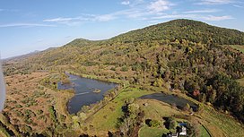
Panoramic image taken from a drone at an altitude of approximately 200 meters in
September, 2014. Facing north, this shows the western side of Battle Mountain and Little Battle Mountain (units of the Robertson River Igneous Suite) on the right. Aaron mountain, composed of sandstone, is visible on the
442:
A unique geological feature of Battle
Mountain is that the western slope outcrops are composed entirely of alkali feldspar granite, while the eastern slope up to and including the summit is entirely rhyolitic. This provides strong evidence of a theorized lateral explosive eruption event centered on
413:
A large white quartz boulder near the base of Battle
Mountain on Viewtown Road in Amissville, VA. The white coloration is indicative of an extremely high SiO2 gas content from highly viscous rhyolitic lava, generated prior to a theorized (Woolman, T.A., 2016) lateral explosion event which may have
553:
The various slopes of Battle
Mountain are in either commercial timber (primarily mixed hardwoods), cattle pasture (western slope) or crops (corn, hay and pumpkins as of 2019). Battle Mountain Farm, which comprises the majority of the eastern slope of Battle Mountain is a mixed hardwood timber and
458:
models including period climate condition-based soil erosion rates, Kirkby's hillslope movement evolution equations and recursive biogeochemical soil erosion rates in felsic granitic conditions. The result was the digital reconstruction image shown on the left, indicating what Battle
Mountain may
429:
Quartz boulder obtained from the eastern (predominately rhyolite) slope of Battle
Mountain, Amissville, Virginia. Rock hammer shown for scale. The reddish-brown mineralization in the quartz is iron (
128:
644:"Petrology and U-PB geochronology of the Robertson River Igneous Suite, Blue Ridge province, Virginia – Evidence for multistage magmatism associated with an early episode of Laurentian rifting"
609:
Richard P. Tollo and Sara Arav (1992). "The
Robertson River Igneous Suite (Blue Ridge Province, Virginia) — Late Proterozoic anorogenic (A-type) granitoids of unique petrochemical affinity".
611:
The
Robertson River Igneous Suite (Blue Ridge Province, Virginia)—Late Proterozoic anorogenic (A-type) granitoids of unique petrochemical affinity. Basement Tectonics 8 (pp. 425–441)
854:
979:
771:
1096:
746:
1187:
263:
Digital terrain model of the western slopes of Battle
Mountain and Little Battle Mountain, generated with data from the NASA ASTER satellite by Woolman (2016).
1106:
949:
527:
left. The Blue Ridge
Mountains of Shenandoah National Park are visible on the horizon. Richmond Road is visible running up through the middle of this image.
510:
relative to feldspar granite and rhyolite, it tends to remain present on the surface while the softer granite it was embedded in wears away into the soil.
80:
389:
693:
Thomas A. Woolman (April 1, 2016). "A Gallium Anomaly Utilized in Palaeogeographic Reconstruction of Battle Mountain, Rappahannock County, Virginia".
443:
the eastern slope at approximately 704 Ma as proposed by Woolman (2016). Further mathematical geology evidence which supports this theory includes a
425:
1177:
1007:
959:
626:
259:
739:
397:
on the eastern slope of Battle Mountain, at an approximate elevation of 850 feet. Emily J. Woolman (aged 4, 2014) is shown for scale.
1192:
378:
on the eastern slopes of Battle Mountain and the adjacent (and geologically related) Little Battle Mountain (elevation 937 feet).
849:
20:
405:
The eastern slope of Battle Mountain, image taken approximately three kilometers from the base on Viewtown Road, Amissville, VA.
119:
523:
381:
168:
1182:
1167:
732:
507:
462:
613:. Proceedings of the International Conferences on Basement Tectonics. Vol. 2. Springer Netherlands. pp. 425–441.
1172:
1022:
755:
141:
73:
682:
Birthdate for the lapetus Ocean? A precise U-Pb zircon and baddeleyite age for the Long Range dikes, southeast Labrador
385:
Theorized original appearance of Battle Mountain at 704 million years ago by Woolman (2016). Elevation shown in meters.
839:
213:
894:
874:
448:
1136:
809:
545:
first as the mountain, including all portions of the July 1863 battlefield exists entirely on private property.
409:
1101:
819:
483:
Battle Mountain and Little Battle Mountain are the only mountains in Rappahannock County which are known to be
347:
124:
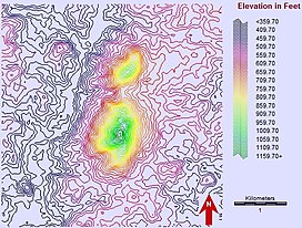
A digital contour plot of Battle Mountain and Little Battle Mountain, based on digital imagery data from the
899:
814:
804:
191:
63:
934:
401:
1091:
1060:
1055:
994:
796:
538:
291:
240:
156:
587:
561:
Front of a t-shirt from 2019 used to promote Battle Mountain Farm's pumpkin growing sales operations
466:
Battle Mountain (center) from approximately eight miles south, driving north on Eggbornsville Road,
1050:
974:
964:
954:
786:
763:
681:
569:
Back of a t-shirt from 2019 used to promote Battle Mountain Farm's pumpkin growing sales operations
541:
at approximately 4 miles away. Access to the mountain and the summit must be negotiated with local
248:
244:
232:
181:
1070:
969:
889:
844:
824:
710:
1111:
37:
1030:
984:
904:
834:
829:
622:
1131:
1126:
944:
909:
879:
859:
702:
655:
614:
418:
1146:
1065:
1040:
924:
776:
471:
444:
337:
312:. This was the beginning of a chain of events that ultimately gave birth to the precursor
163:
276:
and is approximately 704 million years old (+/- 4 million years) as dated using the
487:
in origin, and are among the oldest visibly intact extinct volcanoes in Virginia. White
1012:
919:
914:
884:
371:
313:
306:
273:
149:
1161:
929:
869:
864:
643:
455:
317:
294:
290:
method. It is a unit of the Robertson River Igneous Suite and is located within the
287:
203:
196:
714:
239:. The eastern slope is generally considered to reside in the unincorporated town of
1075:
1045:
939:
781:
494:
and smaller fragments are common on and around Battle Mountain, a result of molten
452:
588:"Robertson River Igneous Suite; Battle Mountain Alkali Feldspar Granite – felsite"
618:
1141:
1116:
1035:
557:
542:
467:
415:
359:
95:
82:
1002:
565:
363:
321:
302:
131:
satellite. Processed by Thomas A. Woolman, PhD (2020), MBA, MS, MS, in 2015.
660:
1121:
706:
491:
484:
375:
340:
325:
251:
lies within private property at an elevation of 1,162 ft (354.2 m).
236:
724:
394:
355:
344:
309:
298:
277:
228:
495:
488:
367:
351:
284:
53:
564:
556:
503:
461:
424:
408:
400:
388:
380:
258:
499:
430:
281:
125:
728:
297:. This volcanic formation was a result of crustal extensional
459:
have looked like 704 million years ago on the western slope.
243:
while the western slope is generally considered to be within
642:
Richard P. Tollo, John N. Aleinikoff (November 1, 1996).
42:
The western slope of Battle Mountain, Castleton, Virginia
479:
Only known volcanic mountains in Rappahannock County, VA
447:
reconstruction of the mountain by Woolman utilizing
1084:
1021:
993:
795:
762:
212:
202:
190:
180:
175:
162:
148:
137:
111:
72:
62:
52:
47:
30:
506:that formed the volcano. As quartz is extremely
740:
695:Transactions of the Kansas Academy of Science
8:
747:
733:
725:
27:
659:
16:Mountain in Rappahannock County, Virginia
579:
272:It is an extinct volcano dating to the
268:Tectonic emplacement and geochronology
7:
1188:Stratovolcanoes of the United States
247:. The entire mountain including the
537:The nearest unincorporated town is
498:that was contained in the rhyolite
14:
515:
118:
36:
21:Battle Mountain (disambiguation)
438:Palaeogeographic reconstruction
414:occurred at 704 Ma during the
1:
1178:Rappahannock County, Virginia
1023:Ridge-and-Valley Appalachians
208:Robertson River Igneous Suite
142:Rappahannock County, Virginia
619:10.1007/978-94-011-1614-5_29
343:rock of the Robertson River
648:American Journal of Science
336:The volcano is composed of
1209:
449:artificial neural networks
58:1,162 ft (354 m)
18:
393:A typical large rhyolite
354:complex material such as
116:
35:
1193:Neoproterozoic volcanism
68:762 ft (232 m)
805:Apple Orchard Mountain
661:10.2475/ajs.296.9.1045
570:
562:
475:
434:
422:
406:
398:
386:
264:
1183:Volcanoes of Virginia
1168:Mountains of Virginia
756:Mountains of Virginia
568:
560:
465:
428:
412:
404:
392:
384:
332:Geochemical evolution
320:at 550 Ma during the
262:
96:38.65722°N 78.06000°W
1173:Blue Ridge Mountains
1061:Massanutten Mountain
1056:Great North Mountain
995:Cumberland Mountains
797:Blue Ridge Mountains
707:10.1660/062.119.0206
539:Amissville, Virginia
241:Amissville, Virginia
157:Blue Ridge Mountains
19:For other uses, see
1051:Fort Lewis Mountain
980:Twelve O'clock Knob
975:Turkeycock Mountain
965:Southwest Mountains
955:Short Hill Mountain
787:Shenandoah Mountain
764:Allegheny Mountains
245:Castleton, Virginia
233:Rappahannock County
171:Massies Corner, Va.
101:38.65722; -78.06000
92: /
1097:Carpenter Mountain
1071:Salt Pond Mountain
970:Stony Man Mountain
890:Mine Bank Mountain
845:Hawksbill Mountain
825:Bull Run Mountains
772:Allegheny Mountain
571:
563:
476:
435:
423:
407:
399:
387:
265:
48:Highest point
1155:
1154:
1031:Beartown Mountain
985:Whitetop Mountain
905:Neighbor Mountain
835:Elk Pond Mountain
830:Catoctin Mountain
628:978-94-010-4703-6
222:
221:
186:704,000,000 years
1200:
1132:Roanoke Mountain
1127:Pantops Mountain
945:Ragged Mountains
910:Old Rag Mountain
880:Maintop Mountain
860:Holston Mountain
855:Hogback Mountain
840:Furnace Mountain
749:
742:
735:
726:
719:
718:
690:
684:
679:
673:
672:
670:
668:
663:
654:(9): 1045–1090.
639:
633:
632:
606:
600:
599:
597:
595:
584:
519:
445:palaeogeographic
350:. This includes
152:
122:
107:
106:
104:
103:
102:
97:
93:
90:
89:
88:
85:
40:
28:
1208:
1207:
1203:
1202:
1201:
1199:
1198:
1197:
1158:
1157:
1156:
1151:
1147:Willis Mountain
1112:Kate's Mountain
1080:
1066:Powell Mountain
1041:Clinch Mountain
1017:
989:
925:Pignut Mountain
895:Mount Jefferson
875:Loudoun Heights
810:Battle Mountain
791:
777:Peters Mountain
758:
753:
723:
722:
692:
691:
687:
680:
676:
666:
664:
641:
640:
636:
629:
608:
607:
603:
593:
591:
586:
585:
581:
576:
551:
535:
530:
529:
528:
525:
520:
481:
472:Culpeper County
440:
338:alkali feldspar
334:
301:of the eastern
270:
257:
225:Battle Mountain
150:
133:
132:
100:
98:
94:
91:
86:
83:
81:
79:
78:
43:
31:Battle Mountain
24:
17:
12:
11:
5:
1206:
1204:
1196:
1195:
1190:
1185:
1180:
1175:
1170:
1160:
1159:
1153:
1152:
1150:
1149:
1144:
1139:
1137:Short Mountain
1134:
1129:
1124:
1119:
1114:
1109:
1107:House Mountain
1104:
1102:Cedar Mountain
1099:
1094:
1088:
1086:
1082:
1081:
1079:
1078:
1073:
1068:
1063:
1058:
1053:
1048:
1043:
1038:
1033:
1027:
1025:
1019:
1018:
1016:
1015:
1013:Tri-State Peak
1010:
1005:
999:
997:
991:
990:
988:
987:
982:
977:
972:
967:
962:
960:Smith Mountain
957:
952:
950:Rocky Mountain
947:
942:
937:
932:
927:
922:
920:Peaks of Otter
917:
915:Paris Mountain
912:
907:
902:
897:
892:
887:
882:
877:
872:
867:
862:
857:
852:
847:
842:
837:
832:
827:
822:
817:
812:
807:
801:
799:
793:
792:
790:
789:
784:
779:
774:
768:
766:
760:
759:
754:
752:
751:
744:
737:
729:
721:
720:
701:(2): 155–172.
685:
674:
634:
627:
601:
578:
577:
575:
572:
550:
547:
534:
531:
522:
521:
514:
513:
512:
480:
477:
456:geostatistical
439:
436:
333:
330:
307:supercontinent
305:margin of the
285:zircon crystal
274:Neoproterozoic
269:
266:
256:
253:
220:
219:
216:
210:
209:
206:
200:
199:
194:
188:
187:
184:
178:
177:
173:
172:
166:
160:
159:
154:
146:
145:
139:
135:
134:
123:
117:
114:
113:
109:
108:
76:
70:
69:
66:
60:
59:
56:
50:
49:
45:
44:
41:
33:
32:
15:
13:
10:
9:
6:
4:
3:
2:
1205:
1194:
1191:
1189:
1186:
1184:
1181:
1179:
1176:
1174:
1171:
1169:
1166:
1165:
1163:
1148:
1145:
1143:
1140:
1138:
1135:
1133:
1130:
1128:
1125:
1123:
1120:
1118:
1115:
1113:
1110:
1108:
1105:
1103:
1100:
1098:
1095:
1093:
1090:
1089:
1087:
1083:
1077:
1074:
1072:
1069:
1067:
1064:
1062:
1059:
1057:
1054:
1052:
1049:
1047:
1044:
1042:
1039:
1037:
1034:
1032:
1029:
1028:
1026:
1024:
1020:
1014:
1011:
1009:
1008:Pine Mountain
1006:
1004:
1001:
1000:
998:
996:
992:
986:
983:
981:
978:
976:
973:
971:
968:
966:
963:
961:
958:
956:
953:
951:
948:
946:
943:
941:
938:
936:
933:
931:
930:Poor Mountain
928:
926:
923:
921:
918:
916:
913:
911:
908:
906:
903:
901:
898:
896:
893:
891:
888:
886:
883:
881:
878:
876:
873:
871:
870:Knob Mountain
868:
866:
865:Humpback Rock
863:
861:
858:
856:
853:
851:
848:
846:
843:
841:
838:
836:
833:
831:
828:
826:
823:
821:
820:Buck Mountain
818:
816:
813:
811:
808:
806:
803:
802:
800:
798:
794:
788:
785:
783:
780:
778:
775:
773:
770:
769:
767:
765:
761:
757:
750:
745:
743:
738:
736:
731:
730:
727:
716:
712:
708:
704:
700:
696:
689:
686:
683:
678:
675:
662:
657:
653:
649:
645:
638:
635:
630:
624:
620:
616:
612:
605:
602:
589:
583:
580:
573:
567:
559:
555:
548:
546:
544:
540:
532:
524:
518:
511:
509:
505:
502:and granitic
501:
497:
493:
490:
486:
478:
473:
469:
464:
460:
457:
454:
450:
446:
437:
432:
427:
420:
417:
411:
403:
396:
391:
383:
379:
377:
373:
369:
365:
361:
357:
353:
349:
346:
342:
339:
331:
329:
327:
323:
319:
318:Iapetus Ocean
315:
311:
308:
304:
300:
296:
295:anticlinorium
293:
289:
288:geochronology
286:
283:
279:
275:
267:
261:
254:
252:
250:
246:
242:
238:
234:
230:
226:
217:
215:
214:Last eruption
211:
207:
205:
204:Volcanic belt
201:
198:
197:Stratovolcano
195:
193:
192:Mountain type
189:
185:
183:
179:
174:
170:
167:
165:
161:
158:
155:
153:
147:
143:
140:
136:
130:
127:
121:
115:
110:
105:
77:
75:
71:
67:
65:
61:
57:
55:
51:
46:
39:
34:
29:
26:
22:
1076:Timber Ridge
1046:Elliott Knob
940:Purcell Knob
900:Mount Rogers
815:Broken Hills
782:Reddish Knob
698:
694:
688:
677:
665:. Retrieved
651:
647:
637:
610:
604:
592:. Retrieved
582:
552:
536:
482:
453:Markov chain
441:
335:
328:transition.
271:
231:mountain in
224:
223:
151:Parent range
25:
1142:Signal Knob
1117:McAfee Knob
1036:Big Schloss
885:Mary's Rock
549:Agriculture
182:Age of rock
99: /
74:Coordinates
1162:Categories
935:The Priest
667:August 22,
594:August 21,
590:. usgs.gov
574:References
543:landowners
468:Rixeyville
416:Cryogenian
374:including
362:-biotite,
360:hornblende
303:Laurentian
292:Blue Ridge
84:38°39′26″N
64:Prominence
1092:Camp Rock
1003:High Knob
850:High Knob
370:granitic
364:magnetite
322:Ediacaran
112:Geography
87:78°3′36″W
54:Elevation
1122:Nakedtop
715:88195835
492:boulders
485:volcanic
376:rhyolite
341:granitic
326:Cambrian
314:Atlantic
237:Virginia
164:Topo map
138:Location
395:outcrop
356:biotite
345:Igneous
310:Rodinia
299:rifting
255:Geology
229:igneous
218:704 Mya
176:Geology
1085:Others
713:
625:
533:Access
496:silica
489:quartz
419:period
368:alkali
366:, and
352:felsic
316:, the
249:summit
227:is an
711:S2CID
504:magma
474:, VA.
348:Suite
129:ASTER
669:2016
623:ISBN
596:2016
508:hard
500:lava
451:and
372:rock
169:USGS
144:, US
126:NASA
703:doi
699:119
656:doi
652:296
615:doi
1164::
709:.
697:.
650:.
646:.
621:.
470:,
433:).
431:Fe
358:,
282:Pb
235:,
748:e
741:t
734:v
717:.
705::
671:.
658::
631:.
617::
598:.
421:.
324:–
280:-
278:U
23:.
Text is available under the Creative Commons Attribution-ShareAlike License. Additional terms may apply.