30:
216:
164:
Barnet's Coast Pilot for the Lakes, on Both Shores: Michigan, Superior, Huron, St. Clair, Erie and
Ontario; Green Bay, Georgian Bay, Grand and Little Traverse Bays; Straits of Mackinaw; the Rivers St. Mary, St. Clair, Detroit, Niagara and St. Laurence. Courses and Distances, Sailing Directions, Etc.
146:
Thompson's Coast Pilot and
Sailing Directions for the North-western Lakes: From Ogdensburg to Buffalo, Chicago, Green Bay, Georgian Bay and Lake Superior, Including All the River Navigation ... Also a Description of Lights and Light-houses ... Harbors Completed, and in Progress of Construction ...
92:
is an ecologically sensitive island of over 800 acres (324 ha), featuring sandy beaches and dunes, juniper bushes, as well as the rare and protected three-pronged awn grass, plus forests of oak, maple, birch and conifer trees and no development of any kind except for simple outhouses to serve
165:
Rearranged, Rev. and
Additions Made from the Latest United States Coast Survey Charts. Also, a Description of All the Lights and Lighthouses. With a Valuable Appendix, and an Alphabetically-arranged Index of the Names of Places
101:
Beckwith Island is undeveloped, though there are two boat anchorage points. One on the north and another on the south side of the islands where the narrows of the two islands meet. Sandy beaches are at both anchorage points.
257:
281:
276:
177:
147:
Cor. and Rev. from the
Original Copies of Thompson's Coast Pilot and the Latest U.S. Surveys, with the Explanation of Nautical Terms
291:
286:
250:
118:
162:
144:
65:
243:
53:
69:
64:
The island's highest elevation is 226 meters (741 feet) above sea level. Like its populated neighbour
77:
80:
lies directly south of the island and
Thunder Beach is located to the southeast of Beckwith Island.
17:
29:
227:
270:
34:
215:
45:
192:
179:
52:, Canada. Beckwith Island and the attached "Little Beckwith" are part of the
223:
49:
89:
73:
28:
37:) to Christian Island, with Beckwith Island on the right.
119:"Missing boater found dead near Beausoleil First Nation"
231:
72:
to the northwest, the uninhabited island is part of an
44:is the eastern of three islands in southeastern
251:
8:
258:
244:
110:
7:
212:
210:
25:
93:boaters, campers and picnickers.
214:
282:Anishinaabe reserves in Ontario
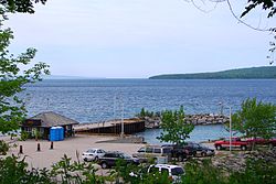
33:Ferry terminal in Cedar Point (
277:Uninhabited islands of Ontario
18:Beckwith Island (Georgian Bay)
1:
230:. You can help Knowledge by
143:Thompson, Thomas S. (1878).
308:
209:
76:reserve. On the mainland,
292:Ontario geography stubs
287:Islands of Georgian Bay
54:Beausoleil First Nation
226:location article is a
161:Barnet, James (1887).
38:
32:
193:44.8568°N 80.1125°W
189: /
39:
239:
238:
198:44.8568; -80.1125
68:to the west, and
16:(Redirected from
299:
260:
253:
246:
218:
211:
204:
203:
201:
200:
199:
194:
190:
187:
186:
185:
182:
170:
169:
158:
152:
151:
140:
134:
133:
131:
130:
115:
66:Christian Island
21:
307:
306:
302:
301:
300:
298:
297:
296:
267:
266:
265:
264:
207:
197:
195:
191:
188:
183:
180:
178:
176:
175:
173:
160:
159:
155:
150:. W.A. Scripps.
142:
141:
137:
128:
126:
117:
116:
112:
108:
99:
86:
84:Flora and fauna
62:
42:Beckwith Island
23:
22:
15:
12:
11:
5:
305:
303:
295:
294:
289:
284:
279:
269:
268:
263:
262:
255:
248:
240:
237:
236:
219:
172:
171:
153:
135:
109:
107:
104:
98:
95:
85:
82:
61:
58:
24:
14:
13:
10:
9:
6:
4:
3:
2:
304:
293:
290:
288:
285:
283:
280:
278:
275:
274:
272:
261:
256:
254:
249:
247:
242:
241:
235:
233:
229:
225:
220:
217:
213:
208:
205:
202:
167:
166:
157:
154:
149:
148:
139:
136:
124:
120:
114:
111:
105:
103:
97:Accessibility
96:
94:
91:
83:
81:
79:
75:
71:
67:
59:
57:
55:
51:
47:
43:
36:
35:Tiny, Ontario
31:
27:
19:
232:expanding it
221:
206:
174:
163:
156:
145:
138:
127:. Retrieved
125:. 2022-09-04
122:
113:
100:
87:
63:
46:Georgian Bay
41:
40:
26:
196: /
78:Cedar Point
70:Hope Island
271:Categories
184:80°06′45″W
181:44°51′24″N
129:2023-01-12
106:References
60:Geography
224:Ontario
50:Ontario
123:Barrie
90:island
74:Ojibwa
222:This
228:stub
88:The
48:in
273::
121:.
56:.
259:e
252:t
245:v
234:.
168:.
132:.
20:)
Text is available under the Creative Commons Attribution-ShareAlike License. Additional terms may apply.