217:
1251:
282:
574:
335:
Native oral history ties the name to a lone hunter in search of deer to feed his clan. He killed a deer but, while returning to the prairie, encountered a bear. The bear held the hunter to the ground, and the hunter appealed to the Great Spirit to release him. The Great Spirit filled the heavens with
445:
272:
While highway signs designate the range as the Bears Paw
Mountains, historically, the names Bearpaw Mountains and Bear Paw Mountains also have been used, including on early state maps of the region. The U.S. Geological Survey continues to use Bearpaw Mountains on publications.
40:
293:
aged igneous intrusions left over from one of the largest eruptive centers in the
Central Montana Alkaline Province. Shonkinite, latite, & tinguatite are among the most common igneous rock compositions found in the Bearpaws.
81:
336:
lightning and thunder, striking the bear dead and severing its paw to release the hunter. Looking at Box Elder Butte, one can see the paw, and
Centennial Mountain to the south resembles a reclining bear.
657:
435:
Aarstad, Rich, Ellie
Arguimbau, Ellen Baumler, Charlene Porsild, and Brian Shovers. Montana Place Names from Alzada to Zortman. Montana Historical Society Press
1290:
1285:
112:
413:
379:
721:
1280:
540:
792:
1275:
835:
404:
370:
345:
647:
606:
524:
815:
181:
1081:
682:
409:
375:
578:
1295:
1051:
704:
1146:
1071:
810:
672:
205:
105:
1236:
1201:
1121:
953:
694:
689:
1196:
1191:
1016:
976:
961:
1300:
1226:
1171:
1131:
1066:
825:
716:
652:
1216:
1186:
1166:
1136:
1116:
1041:
1036:
1031:
996:
966:
667:
486:
Cowell, A.; Taylor, A.; Brockie, T. "Gros Ventre ethnogeography and place names: A diachronic perspective".
399:
365:
1181:
1176:
1161:
1156:
1141:
1111:
1106:
1096:
1091:
1086:
1056:
1046:
1006:
991:
868:
1231:
1221:
1151:
1101:
1026:
1021:
1011:
1001:
986:
981:
971:
782:
1211:
1206:
599:
514:
1126:
1076:
1061:
883:
255:
225:
923:
918:
772:
742:
737:
709:
264:
249:
234:
149:
216:
943:
913:
903:
677:
639:
547:
324:
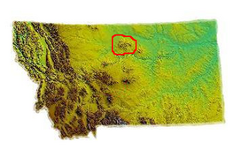
200:, is the highest peak in the range. The Bears Paw Mountains extend in a 45-mile arc between the
928:
888:
878:
853:
848:
843:
520:
301:
858:
747:
592:
495:
316:
220:
McCann Butte in the
Bearpaws, view to the west across glacial moraine. 1920 USGS photograph.
938:
933:
908:
898:
873:
820:
800:
629:
1255:
893:
863:
201:
193:
285:
Bearpaw
Mountains. View south near Clear Creek, Blaine County, Montana. July 31, 1920.
1269:
240:
189:
805:
465:
320:
312:
177:
17:
615:
298:
446:"AISRI Dictionary Database Search--prototype version. Assiniboine. "Montana""
127:
114:
197:
573:
499:
281:
80:
39:
777:
767:
762:
757:
752:
699:
662:
619:
323:
in the foothills of the Bear's Paw
Mountains in October 1877 after the
185:
290:
63:
224:
Locals refer to the range as the
Bearpaws. Indigenous names include
584:
280:
215:
588:
516:
Nez Perce Summer 1877: The U.S. Army and the Nee-Me-Poo Crisis
196:. Baldy Mountain, which rises 6,916 feet (2,108 m) above
432:
304:
outcrops in these mountains, and is named for the range.
44:
Bears Paw
Mountains as seen from near Virgelle, Montana
567:
546:. Montana Department of Transportation. Archived from
952:
834:
791:
730:
638:
289:The core of the Bearpaws are composed of extensive
148:
143:
104:
96:
88:
72:
62:
54:
49:
32:
541:"An Island on the Plains: the Bears Paw Mountains"
519:. Helena, MT: Montana Historical Society Press.
600:
8:
607:
593:
585:
192:, located approximately 10 miles south of
29:
414:United States Department of the Interior
380:United States Department of the Interior
27:Mountain range in Montana, United States
357:
433:Montana Place Names Companion Website
7:
1291:Landforms of Blaine County, Montana
405:Geographic Names Information System
371:Geographic Names Information System
346:List of mountain ranges in Montana
254:'bear's little hand', and
25:
1286:Landforms of Hill County, Montana
468:. Little Big Horn College Library
466:"Apsáalooke Place Names Database"
269:'there are many buttes'.
1249:
816:Regional designations of Montana
572:
513:Greene, Jerome A. (2000). "13".
182:Central Montana Alkalic Province
79:
38:
410:United States Geological Survey
376:United States Geological Survey
1:
1281:Ranges of the Rocky Mountains
206:Rocky Boy Indian Reservation
68:6,916 ft (2,108 m)
488:Anthropological Linguistics
1317:
1276:Mountain ranges of Montana
568:Montana Historical Society
1245:
658:Congressional delegations
626:
176:) are an insular-montane
77:
37:
259:
244:
229:
331:Native American legend
286:
221:
811:Glacier National Park
500:10.1353/anl.2016.0025
400:"Bears Paw Mountains"
284:
239:'bear paws',
219:
128:48.2083°N 109.51750°W
1296:Volcanism of Montana
581:at Wikimedia Commons
319:surrendered to Col.
245:Daxpitcheeischikáate
170:Bear's Paw Mountains
722:Tourist attractions
710:The Last Best Place
579:Bears Paw mountains
162:Bears Paw Mountains
133:48.2083; -109.51750
124: /
33:Bears Paw Mountains
1256:Montana portal
325:Battle of Bear Paw
287:
222:
174:Bearpaw Mountains
166:Bear Paw Mountains
50:Highest point
18:Bear Paw Mountains
1263:
1262:
577:Media related to
553:on June 20, 2010.
302:Bearpaw Formation
268:
253:
238:
184:in north-central
158:
157:
106:Range coordinates
16:(Redirected from
1308:
1301:Eocene volcanoes
1254:
1253:
1252:
609:
602:
595:
586:
576:
555:
554:
552:
545:
537:
531:
530:
510:
504:
503:
483:
477:
476:
474:
473:
462:
456:
455:
453:
452:
442:
436:
430:
424:
423:
421:
420:
396:
390:
389:
387:
386:
366:"Baldy Mountain"
362:
263:
248:
233:
208:south of Havre.
139:
138:
136:
135:
134:
129:
125:
122:
121:
120:
117:
83:
42:
30:
21:
1316:
1315:
1311:
1310:
1309:
1307:
1306:
1305:
1266:
1265:
1264:
1259:
1250:
1248:
1241:
1082:Lewis and Clark
948:
830:
821:Western Montana
801:Eastern Montana
787:
726:
695:Protected areas
634:
622:
613:
564:
559:
558:
550:
543:
539:
538:
534:
527:
512:
511:
507:
485:
484:
480:
471:
469:
464:
463:
459:
450:
448:
444:
443:
439:
431:
427:
418:
416:
398:
397:
393:
384:
382:
364:
363:
359:
354:
342:
333:
310:
279:
214:
154:Late Cretaceous
132:
130:
126:
123:
118:
115:
113:
111:
110:
84:
45:
28:
23:
22:
15:
12:
11:
5:
1314:
1312:
1304:
1303:
1298:
1293:
1288:
1283:
1278:
1268:
1267:
1261:
1260:
1246:
1243:
1242:
1240:
1239:
1234:
1229:
1224:
1219:
1214:
1209:
1204:
1199:
1194:
1189:
1184:
1179:
1174:
1169:
1164:
1159:
1154:
1149:
1144:
1139:
1134:
1129:
1124:
1119:
1114:
1109:
1104:
1099:
1094:
1089:
1084:
1079:
1074:
1069:
1064:
1059:
1054:
1049:
1044:
1039:
1034:
1029:
1024:
1019:
1014:
1009:
1004:
999:
994:
989:
984:
979:
974:
969:
964:
958:
956:
950:
949:
947:
946:
941:
936:
931:
926:
921:
916:
911:
906:
901:
896:
891:
886:
881:
876:
871:
869:Columbia Falls
866:
861:
856:
851:
846:
840:
838:
836:Largest cities
832:
831:
829:
828:
823:
818:
813:
808:
803:
797:
795:
789:
788:
786:
785:
780:
775:
770:
765:
760:
755:
750:
745:
740:
734:
732:
728:
727:
725:
724:
719:
717:Transportation
714:
713:
712:
702:
697:
692:
687:
686:
685:
675:
670:
665:
660:
655:
653:Climate change
650:
644:
642:
636:
635:
627:
624:
623:
614:
612:
611:
604:
597:
589:
583:
582:
570:
563:
562:External links
560:
557:
556:
532:
525:
505:
494:(2): 132–170.
478:
457:
437:
425:
391:
356:
355:
353:
350:
349:
348:
341:
338:
332:
329:
309:
306:
278:
275:
213:
210:
202:Missouri River
194:Havre, Montana
156:
155:
152:
146:
145:
141:
140:
108:
102:
101:
98:
94:
93:
90:
86:
85:
78:
75:
74:
70:
69:
66:
60:
59:
58:Baldy Mountain
56:
52:
51:
47:
46:
43:
35:
34:
26:
24:
14:
13:
10:
9:
6:
4:
3:
2:
1313:
1302:
1299:
1297:
1294:
1292:
1289:
1287:
1284:
1282:
1279:
1277:
1274:
1273:
1271:
1258:
1257:
1244:
1238:
1235:
1233:
1230:
1228:
1225:
1223:
1220:
1218:
1215:
1213:
1210:
1208:
1205:
1203:
1200:
1198:
1195:
1193:
1190:
1188:
1185:
1183:
1180:
1178:
1175:
1173:
1170:
1168:
1165:
1163:
1160:
1158:
1155:
1153:
1150:
1148:
1145:
1143:
1140:
1138:
1135:
1133:
1130:
1128:
1125:
1123:
1120:
1118:
1115:
1113:
1110:
1108:
1105:
1103:
1100:
1098:
1095:
1093:
1090:
1088:
1085:
1083:
1080:
1078:
1075:
1073:
1070:
1068:
1065:
1063:
1060:
1058:
1055:
1053:
1052:Golden Valley
1050:
1048:
1045:
1043:
1040:
1038:
1035:
1033:
1030:
1028:
1025:
1023:
1020:
1018:
1015:
1013:
1010:
1008:
1005:
1003:
1000:
998:
995:
993:
990:
988:
985:
983:
980:
978:
975:
973:
970:
968:
965:
963:
960:
959:
957:
955:
951:
945:
942:
940:
937:
935:
932:
930:
927:
925:
922:
920:
917:
915:
912:
910:
907:
905:
902:
900:
897:
895:
892:
890:
887:
885:
882:
880:
877:
875:
872:
870:
867:
865:
862:
860:
857:
855:
852:
850:
847:
845:
842:
841:
839:
837:
833:
827:
824:
822:
819:
817:
814:
812:
809:
807:
804:
802:
799:
798:
796:
794:
790:
784:
781:
779:
776:
774:
771:
769:
766:
764:
761:
759:
756:
754:
751:
749:
746:
744:
741:
739:
736:
735:
733:
729:
723:
720:
718:
715:
711:
708:
707:
706:
705:State symbols
703:
701:
698:
696:
693:
691:
688:
684:
681:
680:
679:
676:
674:
671:
669:
666:
664:
661:
659:
656:
654:
651:
649:
646:
645:
643:
641:
637:
632:
631:
625:
621:
617:
610:
605:
603:
598:
596:
591:
590:
587:
580:
575:
571:
569:
566:
565:
561:
549:
542:
536:
533:
528:
526:0-917298-68-3
522:
518:
517:
509:
506:
501:
497:
493:
489:
482:
479:
467:
461:
458:
447:
441:
438:
434:
429:
426:
415:
411:
407:
406:
401:
395:
392:
381:
377:
373:
372:
367:
361:
358:
351:
347:
344:
343:
339:
337:
330:
328:
326:
322:
318:
314:
307:
305:
303:
300:
295:
292:
283:
276:
274:
270:
266:
261:
257:
251:
246:
242:
236:
231:
227:
218:
211:
209:
207:
203:
199:
195:
191:
190:United States
187:
183:
179:
175:
171:
167:
163:
153:
151:
147:
142:
137:
109:
107:
103:
99:
95:
92:United States
91:
87:
82:
76:
71:
67:
65:
61:
57:
53:
48:
41:
36:
31:
19:
1247:
1147:Powder River
1072:Judith Basin
806:The Flathead
758:Demographics
683:bibliography
628:
548:the original
535:
515:
508:
491:
487:
481:
470:. Retrieved
460:
449:. Retrieved
440:
428:
417:. Retrieved
403:
394:
383:. Retrieved
369:
360:
334:
321:Nelson Miles
313:Chief Joseph
311:
296:
288:
271:
260:ʔɔɔwɔ́hʔoouh
223:
178:island range
173:
169:
165:
161:
159:
1237:Yellowstone
1202:Sweet Grass
1122:Musselshell
884:Great Falls
826:Yellowstone
783:LGBT rights
256:Gros Ventre
226:Assiniboine
150:Age of rock
131: /
119:109°31.05′W
1270:Categories
1197:Stillwater
1192:Silver Bow
1017:Deer Lodge
977:Broadwater
962:Beaverhead
924:Miles City
919:Livingston
668:Government
472:2019-05-17
451:2012-05-26
419:2019-05-17
385:2019-05-17
352:References
299:Cretaceous
1227:Wheatland
1172:Roosevelt
1132:Petroleum
1067:Jefferson
944:Whitefish
914:Lewistown
904:Kalispell
768:Education
673:Governors
663:Geography
633:(capital)
317:Nez Perce
198:sea level
116:48°12.5′N
73:Geography
64:Elevation
1217:Treasure
1187:Sheridan
1167:Richland
1137:Phillips
1117:Missoula
1042:Garfield
1037:Gallatin
1032:Flathead
997:Chouteau
967:Big Horn
954:Counties
929:Missoula
889:Hamilton
879:Glendive
854:Billings
849:Belgrade
844:Anaconda
778:Politics
773:Gun laws
743:Cannabis
738:Abortion
340:See also
1182:Sanders
1177:Rosebud
1162:Ravalli
1157:Prairie
1142:Pondera
1112:Mineral
1107:Meagher
1097:Madison
1092:Lincoln
1087:Liberty
1057:Granite
1047:Glacier
1007:Daniels
992:Cascade
859:Bozeman
793:Regions
763:Economy
753:Culture
731:Society
678:History
620:Montana
315:of the
308:History
277:Geology
267:
252:
237:
230:Waną́be
186:Montana
180:in the
144:Geology
100:Montana
89:Country
1232:Wibaux
1222:Valley
1152:Powell
1102:McCone
1027:Fergus
1022:Fallon
1012:Dawson
1002:Custer
987:Carter
982:Carbon
972:Blaine
939:Sidney
934:Polson
909:Laurel
899:Helena
874:Dillon
700:Sports
690:People
640:Topics
630:Helena
523:
291:Eocene
1212:Toole
1207:Teton
894:Havre
864:Butte
748:Crime
648:Index
616:State
551:(PDF)
544:(PDF)
97:State
1127:Park
1077:Lake
1062:Hill
521:ISBN
297:The
265:lit.
250:lit.
241:Crow
235:lit.
212:Name
204:and
160:The
55:Peak
618:of
496:doi
172:or
1272::
492:58
490:.
412:,
408:.
402:.
378:,
374:.
368:.
327:.
262:,
258::
247:,
243::
232:,
228::
188:,
168:,
608:e
601:t
594:v
529:.
502:.
498::
475:.
454:.
422:.
388:.
164:(
20:)
Text is available under the Creative Commons Attribution-ShareAlike License. Additional terms may apply.