29:
553:
355:
255:
365:
283:. Petoskey was at first known as "Bear River" until being renamed in 1873. The Bear River itself has also been known as "Bear Creek" and "Ellis Creek".
558:
568:
350:
291:
193:
397:
382:
360:
241:
563:
340:
183:
171:
286:
The river has excellent fishing and provides opportunities for peaceful canoeing or kayaking. The river is great for
425:
370:
226:
392:
523:
512:
446:
501:
490:
479:
468:
457:
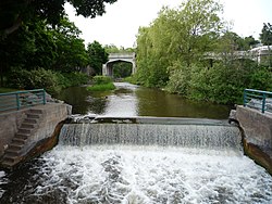
336:
Including
Walloon Lake, the Bear River system drains all or portions of the following cities and townships:
230:
377:
345:
222:
187:
245:
167:
106:
387:
249:
34:
28:
429:
234:
547:
491:
U.S. Geological Survey
Geographic Names Information System: North Branch Spring Brook
469:
U.S. Geological Survey
Geographic Names Information System: South Branch Spring Brook
175:
421:
U.S. Geological Survey. National
Hydrography Dataset high-resolution flowline data.
287:
179:
80:
240:
The river flows east for about 2 miles (3 km) before turning north through
91:
538:
159:
270:
257:
208:
195:
502:
U.S. Geological Survey
Geographic Names Information System: Hay Marsh Creek
524:
U.S. Geological Survey
Geographic Names Information System: Schoofs Creek
422:
163:
50:
480:
U.S. Geological Survey
Geographic Names Information System: Gimlet Creek
458:
U.S. Geological Survey
Geographic Names Information System: Spring Brook
513:
U.S. Geological Survey
Geographic Names Information System: Wallon Lake
447:
U.S. Geological Survey
Geographic Names Information System: Bear River
290:
fishing. For most of its path in Emmet County, River Road and the
166:. 14.7 miles (23.7 km) long, it is the largest tributary of
143:
133:
125:
120:
112:
100:
90:
74:
66:
57:
46:
41:
21:
190:, draining from the southeast end of the lake at
233:has its northern terminus in a junction with
8:
158:is a small clear slow-moving river in the
178:. The river is formed as the outflow of
33:The Bear River flowing through downtown
411:
294:parallel the river on its west banks.
18:
554:Rivers of Charlevoix County, Michigan
417:
415:
7:
442:
440:
438:
306:(right) South Branch Spring Brook
244:, angling northwest to empty into
14:
559:Rivers of Emmet County, Michigan
314:(left) North Branch Spring Brook
27:
16:River in Michigan, United States
292:Tuscola and Saginaw Bay Railway
1:
58:Physical characteristics
569:Tributaries of Lake Michigan
432:, accessed November 21, 2011
102: • location
76: • location
585:
116:14.7 miles (23.7 km)
86:
62:
26:
182:on the boundary between
170:in the northwest of the
145: • right
319:(right) Hay Marsh Creek
135: • left
221:near the community of
174:. Traverse Bay is on
539:Bear River on Fishweb
351:Boyne Valley Township
271:45.37722°N 84.96083°W
209:45.26111°N 84.93361°W
309:(right) Gimlet Creek
303:(left) Spring Brook
398:Springvale Township
383:Bear Creek Township
361:Evangeline Township
276:45.37722; -84.96083
267: /
246:Little Traverse Bay
242:Bear Creek Township
214:45.26111; -84.93361
205: /
168:Little Traverse Bay
121:Basin features
107:Little Traverse Bay
564:Rivers of Michigan
428:2012-03-29 at the
356:Chandler Township
341:Charlevoix County
184:Charlevoix County
153:
152:
576:
526:
521:
515:
510:
504:
499:
493:
488:
482:
477:
471:
466:
460:
455:
449:
444:
433:
423:The National Map
419:
371:Melrose Township
282:
281:
279:
278:
277:
272:
268:
265:
264:
263:
260:
227:Melrose Township
220:
219:
217:
216:
215:
210:
206:
203:
202:
201:
198:
146:
136:
77:
31:
19:
584:
583:
579:
578:
577:
575:
574:
573:
544:
543:
535:
530:
529:
522:
518:
511:
507:
500:
496:
489:
485:
478:
474:
467:
463:
456:
452:
445:
436:
430:Wayback Machine
420:
413:
408:
393:Resort Township
366:Hudson Township
334:
300:
275:
273:
269:
266:
261:
258:
256:
254:
253:
213:
211:
207:
204:
199:
196:
194:
192:
191:
172:lower peninsula
144:
139:Hay Marsh Creek
134:
103:
75:
53:, United States
37:
17:
12:
11:
5:
582:
580:
572:
571:
566:
561:
556:
546:
545:
542:
541:
534:
533:External links
531:
528:
527:
516:
505:
494:
483:
472:
461:
450:
434:
410:
409:
407:
404:
403:
402:
401:
400:
395:
390:
385:
375:
374:
373:
368:
363:
358:
353:
348:
333:
332:Drainage basin
330:
329:
328:
327:
326:
320:
317:
316:
315:
312:
311:
310:
299:
296:
151:
150:
147:
141:
140:
137:
131:
130:
127:
123:
122:
118:
117:
114:
110:
109:
104:
101:
98:
97:
94:
88:
87:
84:
83:
78:
72:
71:
68:
64:
63:
60:
59:
55:
54:
48:
44:
43:
39:
38:
32:
24:
23:
15:
13:
10:
9:
6:
4:
3:
2:
581:
570:
567:
565:
562:
560:
557:
555:
552:
551:
549:
540:
537:
536:
532:
525:
520:
517:
514:
509:
506:
503:
498:
495:
492:
487:
484:
481:
476:
473:
470:
465:
462:
459:
454:
451:
448:
443:
441:
439:
435:
431:
427:
424:
418:
416:
412:
405:
399:
396:
394:
391:
389:
386:
384:
381:
380:
379:
376:
372:
369:
367:
364:
362:
359:
357:
354:
352:
349:
347:
344:
343:
342:
339:
338:
337:
331:
325:Schoofs Creek
324:
323:
322:Walloon Lake
321:
318:
313:
308:
307:
305:
304:
302:
301:
297:
295:
293:
289:
284:
280:
251:
247:
243:
238:
236:
232:
228:
224:
218:
189:
185:
181:
177:
176:Lake Michigan
173:
169:
165:
161:
157:
148:
142:
138:
132:
128:
124:
119:
115:
111:
108:
105:
99:
95:
93:
89:
85:
82:
79:
73:
69:
65:
61:
56:
52:
49:
45:
40:
36:
30:
25:
20:
519:
508:
497:
486:
475:
464:
453:
378:Emmet County
346:Bay Township
335:
285:
239:
223:Walloon Lake
188:Emmet County
180:Walloon Lake
155:
154:
149:Spring Brook
81:Walloon Lake
298:Tributaries
274: /
212: /
126:Tributaries
548:Categories
406:References
262:84°57′39″W
259:45°22′38″N
200:84°56′01″W
197:45°15′40″N
160:U.S. state
156:Bear River
22:Bear River
426:Archived
388:Petoskey
250:Petoskey
237:nearby.
164:Michigan
51:Michigan
42:Location
35:Petoskey
47:Country
235:US 131
129:
113:Length
96:
70:
67:Source
288:smelt
92:Mouth
231:M-75
186:and
252:at
248:in
225:in
162:of
550::
437:^
414:^
229:.
Text is available under the Creative Commons Attribution-ShareAlike License. Additional terms may apply.