367:, and William J. Duley, as 20 blocks on 40 acres (160,000 m). Beaver had a post office from 1857 to 1906. At one time, the community also had a flour mill, hardware store, general store, Methodist church, blacksmith, wagon shop, saloon (maybe two), hotel, school, and cheese factory. However, the farming practices up the hillsides encouraged erosion, and the high hills produced frequent flooding. At first rich soil came down the hillsides when rains came. Then sand from the underlying sandstone was washed down year after year covering everything. Some years because of the flooding the farmers had to plant three times. The flood deposits devastated the area, and today, most of the site is overgrown and much is swampy. In 1932, the state purchased most of the land, buildings were torn down and the Beaver area became a nature reserve.
674:
73:
108:
56:
115:
80:
362:
valley. The name came from observing beavers building dams on the creek that travels through the site to join with the
Whitewater River. Following the example of the beavers, the early settlers decided to dam the creek to furnish power for a mill. The community was platted in 1856 by Albert Hopson,
370:
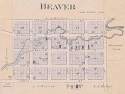
Eleanor Putnam, age 89 in 2009, a former resident of Beaver during her childhood in the 1920s and 1930s, recalled climbing the hills around Beaver, and how her family farmed the rugged land. She recalled her uncle struggling to climb the hills to farm the top of a plateau, which can be seen in
492:
Jostad, Karen. (1972) "The Buried Town of Beaver." Minnesota State Dept. of
Natural Resources, St. Paul. Bureau of Information and Education, ERIC Number: ED072966 (also available in the Minnesota State University
1013:
465:
550:
1008:
738:
748:
728:
723:
758:
773:
307:
214:
713:
753:
743:
693:
703:
502:
783:
778:
768:
733:
462:
763:
718:
449:
708:
698:
143:
543:
371:
aerial photos. The Beaver
Cemetery, just west of the old community center, is where many of the original settlers of Beaver were laid to rest.
841:
440:
287:
107:
536:
72:
445:
209:
528:
197:
359:
347:
955:
514:
319:
55:
638:
400:
978:
560:
311:
275:
202:
175:
481:
435:
871:
793:
643:
24:
648:
621:
335:
945:
922:
886:
343:
20:
358:
Beaver was settled in 1854, by people from New
England. It was the first community established in the
985:
851:
632:
331:
248:
897:
892:
881:
866:
821:
811:
801:
653:
627:
616:
303:
46:
907:
856:
836:
950:
940:
917:
912:
876:
663:
606:
601:
582:
339:
323:
238:
846:
806:
658:
482:
U.S. Geological Survey
Geographic Names Information System: Beaver Post Office (historical)
902:
861:
611:
469:
327:
685:
364:
1002:
280:
518:
575:
932:
185:
158:
145:
315:
229:
190:
969:‡This populated place also has portions in an adjacent county or counties
263:
673:
255:
234:
593:
532:
672:
1014:
Unincorporated communities in Winona County, Minnesota
472:. Minnesota Historical Society. Accessed June 2, 2009.
32:
Unincorporated community in
Minnesota, United States
16:
Unincorporated community in
Minnesota, United States
964:
931:
820:
792:
684:
592:
286:
274:
262:
245:
228:
220:
208:
196:
184:
174:
37:
322:and Winona County Road 30. Nearby places include
318:, United States, located near the junction of
544:
350:and Beaver Creek both flow through the area.
8:
677:Map of Minnesota highlighting Winona County
551:
537:
529:
373:
34:
94:within Whitewater Township, Winona County
450:United States Department of the Interior
1009:Unincorporated communities in Minnesota
427:
285:
261:
227:
219:
173:
138:
64:
52:
393:
273:
244:
207:
195:
183:
7:
441:Geographic Names Information System
92:Location of the community of Beaver
559:Municipalities and communities of
519:"Census of Population and Housing"
383:
14:
113:
106:
78:
71:
54:
446:United States Geological Survey
114:
79:
1:
130:Show map of the United States
503:GNIS Data on Beaver Cemetery
515:United States Census Bureau
1030:
127:Beaver (the United States)
18:
974:
670:
573:
414:
399:
392:
387:
382:
379:
139:
65:
53:
44:
562:Winona County, Minnesota
304:unincorporated community
224:709 ft (216 m)
47:Unincorporated community
19:Not to be confused with
60:1894 plat map of Beaver
25:Beaver Creek, Minnesota
678:
159:44.152917°N 92.02000°W
676:
463:Minnesota Place Names
415:U.S. Decennial Census
375:Historical population
344:Whitewater State Park
247: • Summer (
97:Show map of Minnesota
21:Beaver Bay, Minnesota
987:United States portal
164:44.152917; -92.02000
436:"Beaver, Minnesota"
376:
308:Whitewater Township
215:Whitewater Township
155: /
679:
468:2011-06-15 at the
374:
996:
995:
419:
418:
297:
296:
1021:
988:
981:
980:Minnesota portal
956:Whitewater Falls
675:
585:
578:
568:
563:
553:
546:
539:
530:
523:
522:
511:
505:
500:
494:
490:
484:
479:
473:
460:
454:
453:
432:
395:
390:
385:
377:
348:Whitewater River
320:State Highway 74
252:
170:
169:
167:
166:
165:
160:
156:
153:
152:
151:
148:
131:
117:
116:
110:
98:
82:
81:
75:
58:
35:
1029:
1028:
1024:
1023:
1022:
1020:
1019:
1018:
999:
998:
997:
992:
986:
979:
970:
960:
927:
823:
816:
788:
680:
668:
588:
583:
576:
569:
566:
561:
557:
527:
526:
513:
512:
508:
501:
497:
491:
487:
480:
476:
470:Wayback Machine
461:
457:
434:
433:
429:
424:
388:
356:
270:
246:
163:
161:
157:
154:
149:
146:
144:
142:
141:
135:
134:
133:
132:
129:
128:
125:
124:
123:
122:
118:
101:
100:
99:
96:
95:
93:
90:
89:
88:
87:
83:
61:
49:
40:
33:
28:
17:
12:
11:
5:
1027:
1025:
1017:
1016:
1011:
1001:
1000:
994:
993:
991:
990:
983:
975:
972:
971:
968:
966:
962:
961:
959:
958:
953:
948:
943:
937:
935:
929:
928:
926:
925:
920:
915:
910:
905:
900:
895:
890:
884:
879:
874:
869:
864:
859:
854:
849:
844:
839:
834:
828:
826:
822:Unincorporated
818:
817:
815:
814:
809:
804:
798:
796:
790:
789:
787:
786:
781:
776:
771:
766:
761:
756:
751:
746:
741:
736:
731:
726:
721:
716:
711:
706:
701:
696:
690:
688:
682:
681:
671:
669:
667:
666:
661:
656:
651:
646:
641:
639:Minnesota City
636:
630:
625:
619:
614:
609:
604:
598:
596:
590:
589:
574:
571:
570:
558:
556:
555:
548:
541:
533:
525:
524:
506:
495:
485:
474:
455:
426:
425:
423:
420:
417:
416:
412:
411:
408:
406:
403:
397:
396:
391:
386:
381:
365:Sheldon Brooks
355:
352:
295:
294:
291:
284:
283:
278:
272:
271:
268:
266:
260:
259:
253:
243:
242:
232:
226:
225:
222:
218:
217:
212:
206:
205:
200:
194:
193:
188:
182:
181:
178:
172:
171:
137:
136:
126:
120:
119:
112:
111:
105:
104:
103:
102:
91:
85:
84:
77:
76:
70:
69:
68:
67:
66:
63:
62:
59:
51:
50:
45:
42:
41:
38:
31:
15:
13:
10:
9:
6:
4:
3:
2:
1026:
1015:
1012:
1010:
1007:
1006:
1004:
989:
984:
982:
977:
976:
973:
967:
963:
957:
954:
952:
949:
947:
944:
942:
939:
938:
936:
934:
930:
924:
921:
919:
916:
914:
911:
909:
906:
904:
901:
899:
896:
894:
891:
888:
885:
883:
880:
878:
875:
873:
870:
868:
865:
863:
860:
858:
855:
853:
850:
848:
845:
843:
840:
838:
835:
833:
830:
829:
827:
825:
819:
813:
810:
808:
805:
803:
800:
799:
797:
795:
791:
785:
782:
780:
777:
775:
772:
770:
767:
765:
762:
760:
757:
755:
752:
750:
747:
745:
742:
740:
739:Pleasant Hill
737:
735:
732:
730:
727:
725:
722:
720:
717:
715:
712:
710:
707:
705:
702:
700:
697:
695:
692:
691:
689:
687:
683:
665:
662:
660:
657:
655:
652:
650:
647:
645:
642:
640:
637:
634:
631:
629:
626:
623:
620:
618:
615:
613:
610:
608:
605:
603:
600:
599:
597:
595:
591:
587:
586:
579:
572:
567:United States
564:
554:
549:
547:
542:
540:
535:
534:
531:
520:
516:
510:
507:
504:
499:
496:
489:
486:
483:
478:
475:
471:
467:
464:
459:
456:
451:
447:
443:
442:
437:
431:
428:
421:
413:
409:
407:
404:
402:
398:
378:
372:
368:
366:
361:
353:
351:
349:
345:
341:
337:
333:
329:
325:
321:
317:
313:
312:Winona County
309:
305:
301:
292:
289:
282:
279:
277:
267:
265:
257:
254:
250:
240:
239:Central (CST)
236:
233:
231:
223:
216:
213:
211:
204:
203:Winona County
201:
199:
192:
189:
187:
180:United States
179:
177:
168:
140:Coordinates:
109:
74:
57:
48:
43:
36:
30:
26:
22:
872:New Hartford
831:
749:Rollingstone
729:New Hartford
644:Rollingstone
581:
509:
498:
488:
477:
458:
439:
430:
369:
357:
299:
298:
147:44°09′10.5″N
29:
933:Ghost towns
842:Centerville
824:communities
759:St. Charles
649:St. Charles
622:La Crescent
577:County seat
336:St. Charles
162: /
1003:Categories
946:Enterprise
923:Wyattville
887:Pine Creek
774:Whitewater
724:Mt. Vernon
422:References
360:Whitewater
290:feature ID
150:92°01′12″W
965:Footnotes
852:Donehower
714:Hillsdale
686:Townships
633:Minneiska
493:Library).
332:Plainview
316:Minnesota
276:Area code
230:Time zone
221:Elevation
191:Minnesota
898:Saratoga
893:Ridgeway
882:Oakridge
867:Lamoille
812:Pickwick
802:Dresbach
754:Saratoga
744:Richmond
694:Dresbach
654:Stockton
628:Lewiston
617:Goodview
466:Archived
264:ZIP code
210:Township
908:Whitman
857:Fremont
837:Bethany
704:Fremont
354:History
176:Country
951:Grover
941:Ashton
918:Witoka
913:Wilson
877:Nodine
832:Beaver
784:Wiscoy
779:Wilson
769:Warren
734:Norton
664:Winona
607:Dakota
602:Altura
594:Cities
584:Winona
380:Census
346:. The
342:, and
340:Weaver
324:Altura
302:is an
300:Beaver
293:654592
198:County
121:Beaver
86:Beaver
39:Beaver
847:Clyde
807:Homer
764:Utica
719:Homer
659:Utica
269:55910
258:(CDT)
256:UTC-5
235:UTC-6
186:State
903:Troy
862:Hart
794:CDPs
709:Hart
699:Elba
612:Elba
401:1880
389:Note
384:Pop.
363:Dr.
328:Elba
288:GNIS
306:in
281:507
249:DST
23:or
1005::
580::
565:,
517:.
448:,
444:.
438:.
405:86
394:%±
338:,
334:,
330:,
326:,
314:,
310:,
889:‡
635:‡
624:‡
552:e
545:t
538:v
521:.
452:.
410:—
251:)
241:)
237:(
27:.
Text is available under the Creative Commons Attribution-ShareAlike License. Additional terms may apply.