22:
30:
461:
372:
70:. The area is divided into 2 parishes (postal codes 8330 and 8340) and comprises 7x7 square kilometres with approximately 9000 inhabitants. Both Beder and Malling supports a small train station and in the vicinity of the 2 main towns there are 9 smaller villages. Beder is the 3rd most densely populated area within the municipality (1. Aarhus, 2. Lystrup, 3. Beder).
128:
59:
The town shares a sporting complex with neighbouring town
Malling called Egelund, where the team BMI (Beder Malling Idrætsforening) plays their football, handball, basketball, etc., matches.
521:
380:
212:
74:
502:
526:
422:
93:
205:
495:
198:
488:
178:
468:
173:
29:
63:
21:
97:
49:
132:
346:
286:
241:
155:
182:
472:
460:
371:
251:
145:
515:
281:
271:
261:
160:
361:
306:
52:
has since 2012 considered the towns one urban area making it the 84th largest in
331:
296:
276:
48:. Some consider Beder & the neighbouring town of Malling as one urban area.
356:
311:
266:
437:
424:
77:, offering gardening, floristry, forestry and nature technician programmes.
190:
127:
403:
398:
393:
388:
336:
321:
316:
256:
236:
67:
291:
53:
45:
41:
408:
351:
341:
301:
222:
246:
326:
28:
20:
109:
194:
40:
is a town with a population of 4,372 (9 January 2012) in
476:
144:
62:
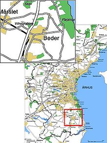
Beder-Malling is located in the southernmost part of
379:
229:
94:"BEF44: Population 1st January, by urban areas"
496:
206:
8:
522:Towns and settlements in Aarhus Municipality
503:
489:
213:
199:
191:
138:
56:with a total population of 8,898 in 2020.
149:
141:
75:Aarhus Educational Centre for Agriculture
86:
467:This article about a location in the
7:
457:
455:
14:
459:
370:
126:
73:Beder is home to a division of
33:Location of Beder, near Aarhus.
1:
527:Central Denmark Region stubs
475:. You can help Knowledge by
543:
454:
368:
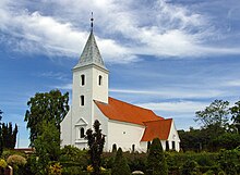
25:Chapel in Beder, Aarhus
469:Central Denmark Region
34:
26:
32:
24:
135:at Wikimedia Commons
434: /
221:Neighbourhoods in
150:Following station
142:Preceding station
98:Statistics Denmark
64:Århus Municipality
35:
27:
484:
483:
438:56.067°N 10.217°E
417:
416:
189:
188:
131:Media related to
110:"Statistikbanken"
534:
505:
498:
491:
463:
456:
449:
448:
446:
445:
444:
439:
435:
432:
431:
430:
427:
374:
215:
208:
201:
192:
139:
130:
114:
113:
106:
100:
91:
542:
541:
537:
536:
535:
533:
532:
531:
512:
511:
510:
509:
452:
442:
440:
436:
433:
428:
425:
423:
421:
420:
418:
413:
375:
366:
225:
219:
185:
163:
123:
118:
117:
108:
107:
103:
92:
88:
83:
17:
16:Town in Denmark
12:
11:
5:
540:
538:
530:
529:
524:
514:
513:
508:
507:
500:
493:
485:
482:
481:
464:
443:56.067; 10.217
415:
414:
412:
411:
406:
401:
396:
391:
385:
383:
377:
376:
369:
367:
365:
364:
359:
354:
349:
344:
339:
334:
329:
324:
319:
314:
309:
304:
299:
294:
289:
284:
279:
274:
269:
264:
259:
254:
252:Frederiksbjerg
249:
244:
239:
233:
231:
230:Neighbourhoods
227:
226:
220:
218:
217:
210:
203:
195:
187:
186:
179:Lisbjergskolen
176:
171:
169:
166:
164:
158:
152:
151:
148:
146:Aarhus Letbane
143:
137:
136:
122:
121:External links
119:
116:
115:
101:
96:database from
85:
84:
82:
79:
66:bordering the
15:
13:
10:
9:
6:
4:
3:
2:
539:
528:
525:
523:
520:
519:
517:
506:
501:
499:
494:
492:
487:
486:
480:
478:
474:
470:
465:
462:
458:
453:
450:
447:
410:
407:
405:
402:
400:
397:
395:
392:
390:
387:
386:
384:
382:
378:
373:
363:
360:
358:
355:
353:
350:
348:
345:
343:
340:
338:
335:
333:
330:
328:
325:
323:
320:
318:
315:
313:
310:
308:
305:
303:
300:
298:
295:
293:
290:
288:
285:
283:
280:
278:
275:
273:
270:
268:
265:
263:
260:
258:
255:
253:
250:
248:
245:
243:
240:
238:
235:
234:
232:
228:
224:
216:
211:
209:
204:
202:
197:
196:
193:
184:
180:
175:
172:
170:
167:
165:
162:
157:
154:
153:
147:
140:
134:
129:
125:
124:
120:
111:
105:
102:
99:
95:
90:
87:
80:
78:
76:
71:
69:
65:
60:
57:
55:
51:
47:
43:
39:
31:
23:
19:
477:expanding it
466:
451:
419:
174:Vilhelmsborg
104:
89:
72:
61:
58:
37:
36:
18:
441: /
516:Categories
267:Hasselager
81:References
381:Districts
347:Vesterbro
332:Tranbjerg
242:Docklands
404:Brabrand
399:Aarhus V
394:Aarhus N
389:Aarhus C
337:Trøjborg
322:Stavtrup
297:Rosenhøj
287:Midtbyen
277:Højbjerg
257:Gellerup
237:Brabrand
177:towards
159:towards
68:Kattegat
429:10°13′E
426:56°04′N
312:Skæring
292:Risskov
183:Lystrup
168:Line 2
156:Malling
54:Denmark
46:Denmark
42:Jutland
409:Viby J
357:Åbyhøj
342:Vejlby
302:Skejby
223:Aarhus
471:is a
327:Tilst
317:Skåde
272:Holme
262:Hasle
161:Odder
133:Beder
38:Beder
473:stub
352:Viby
307:Slet
282:Kolt
362:Åby
247:Egå
181:or
50:DST
44:in
518::
504:e
497:t
490:v
479:.
214:e
207:t
200:v
112:.
Text is available under the Creative Commons Attribution-ShareAlike License. Additional terms may apply.