397:, which Beechboro Road passes over, with the two roads having had formerly intersected with each other at traffic lights before 2018. Following this flyover the suburb is now within the residential suburb of Bennett Springs, encountering a roundabout with Orchid Avenue and Bridgeman Drive and a T-junction with Bennett Springs Drive, all within 750 metres (2,460 ft) before intersecting with Marshall Road at traffic lights. Following this intersection Beechboro Road North promptly reduces to a two-lane single carriageway, travelling northwards within Whiteman for about 1.8 kilometres (1.1 mi), during which it forms part of the western border of Whiteman Park, sits near bushland which is expected to be the location for the future Malaga railway station on the upcoming
562:
1137:
1362:
836:
779:
592:
509:
182:
147:
718:
557:
138:
63:
447:
Cullacabardee community and
Whiteman Park hobby clubs, which it still does today. As a result of the NorthLink WA works, the road was permanently closed north of Jules Steiner Memorial Drive (the entrance road to the shooting complex) in January 2019, and reduced to a local access road. The road is accessible from a left-in/left-out intersection at Beechboro Road North.
377:(2,600 ft) takes the road to a traffic light controlled intersection with Collier Road. The road turns right after 100 metres (330 ft), while the main traffic flow continues northwards as Embleton Avenue, and terminates in a cul-de-sac north of Tonkin Highway 700 metres (2,300 ft) north-eastwards.
417:
Upon the completion of the nearby section of Tonkin
Highway from Railway Parade to Morley Drive in 1984, Beechboro Road was split into two parts, becoming discontinuous on both sides of the highway. In 1992, the intersection with Reid Highway opened when it was extended eastwards from Tonkin Highway.
388:
Beechboro Road North commences at a cul-de-sac north of Tonkin
Highway in Embleton. 350 metres (1,150 ft) later, the road encounters a traffic light intersection with Broun Avenue to the west and Walter Road East to the east, gaining the State Route 53 north of that intersection. Now within the
437:
in 2023. Prior to the rebuild
Beechboro Road South commenced as a continuation of Railway Parade 200 m east of a traffic light controlled T-junction with Coode Street in the Bayswater town centre. Since the rebuild of Bayswater as an elevated train station Beechboro Road South now connects directly
421:
In 2010, a new extension of
Hepburn Avenue to Beechboro Road North opened nearby, resulting in the latter being realigned with Beechboro Road traffic coming from the south continuing as Pass Way that would terminate at Hepburn Avenue. To continue onto Beechboro Road North, traffic had to turn right
446:
Hennessey Road is the current name of the original section of
Beechboro Road North between Hepburn Avenue and Gnangara Road. This section of the route provided a link to Gnangara Road and Ellenbrook from Marshall Road when it was still part of Beechboro Road North, as well as provide access to the
429:
between Reid and Tonkin
Highways. The road was also realigned to connect with Hepburn Avenue at a roundabout interchange with Tonkin Highway, which shortened its original length by nearly 7 km, and the road was duplicated in the vicinity of the interchange. The section from Hepburn Avenue to
376:
Beechboro Road South commences as an continuation of
Whatley Crescent at a traffic light controlled T-junction with Rose Avenue in the Bayswater town centre. The road initially runs through residential areas but transitions to industrial areas after 1 kilometre (0.62 mi). Another 800 metres
405:
project, and intersects with
Whiteman Drive (an entrance to Whiteman Park) and Hennessey Road (the former section of Beechboro Road North between Hepburn Avenue and Gnangara Road). Beechboro Road North ends at a roundabout interchange with Tonkin Highway, continuing westwards as Hepburn Avenue.
389:
suburb of Morley and a four-lane single carriageway, the road intersects at traffic lights with Morley Drive East 650 metres (2,130 ft) later, and then, now a dual carriageway, another 1.5 kilometres (0.93 mi) later takes the road to
430:
Gnangara Road was also affected due to Tonkin
Highway crossing its path and passing just south of its original northern terminus with Gnangara Road, with said section becoming a cul-de-sac at its northern end, and renamed Hennessey Road.
372:
Beechboro Road South runs entirely through Bayswater and is 2.6 kilometres (1.6 mi) long. The road is mostly a two-lane single carriageway and runs through residential and some industrial areas upon reaching its northern end.
336:
road project between 2016 and 2019, Beechboro Road was one of northeastern Perth's most important routes. The road is discontinuous at Tonkin Highway, with the section from Tonkin Highway to Walter Road officially known as
425:
Beechboro Road North was heavily affected during the NorthLink WA road project during 2018 and 2019. The intersection with Reid Highway was converted to a flyover due to its close proximity to the
1021:
Unsignalised T-intersection. Traffic continuing on Beechboro Road South must turn here. Traffic connecting to/from Beechboro Road North must continue straight via Embleton then Broun Avenues.
385:
Beechboro Road North is 9.2 kilometres (5.7 mi) long and is part of State Route 53. The road is mostly two lanes in each direction which alternates between single and dual carriageway.
1215:
Western Australia. Main Roads Dept; Western Australia. Environmental Protection Authority; Western Australia. Main Roads Dept. Metropolitan Operations Directorate (1993),
1264:
Reid Highway - Beechboro Road to Great Northern Highway : Main Roads of Western Australia : report and recommendations of the Environmental Protection Authority
105:
414:
The road was first commissioned during the 1970s as a road that tracked the then-new northeastern suburbs of Perth, running all the way to Gnangara Road.
1920:
1901:
1739:
1734:
1729:
1724:
1719:
1714:
1709:
1704:
1699:
1694:
1689:
1684:
1679:
1674:
1669:
1664:
1659:
1654:
1649:
1644:
1639:
1634:
1629:
1624:
1619:
1614:
1609:
1604:
1599:
1594:
1589:
1584:
1579:
1574:
1569:
1564:
1559:
1554:
1549:
1544:
1539:
1534:
1529:
1524:
1519:
1514:
1509:
1504:
1499:
1494:
1489:
1484:
1479:
1474:
1469:
1464:
1459:
1443:
1438:
1422:
1417:
1412:
1334:
863:
State Route 53 southern concurrency terminus. Traffic connecting to/from Beechboro Road South must turn and follow Broun then Embleton Avenues.
589:
Current northern terminus for both Beechboro Road North and State Route 53 at a roundabout interchange favouring Tonkin Highway. Continues as
1890:
1885:
1880:
1875:
1870:
1865:
1860:
1855:
1850:
1845:
1840:
1835:
1830:
1825:
1820:
1815:
1810:
1805:
1800:
1795:
1790:
1785:
1780:
1775:
1770:
1765:
1760:
1755:
1271:
1171:
1305:
398:
700:
681:
642:
393:, also at traffic lights. The road travels through the suburb of Beechboro for another 1.5 kilometres (0.93 mi) before reaching
1101:
534:
497:
434:
305:
1080:
1073:
1041:
857:
575:
727:
Replaced with a flyover since 2019 as part of the NorthLink WA project. Previously a traffic light controlled instruction
1327:
1055:
984:
872:
853:
813:
796:
761:
757:
704:
528:
402:
325:
301:
275:
155:
1097:
1069:
980:
868:
819:
792:
646:
603:
540:
244:
209:
753:
663:
422:
at the roundabout. This alignment was later removed in 2018 as part of nearby works for the NorthLink WA project.
1037:
1015:
807:
737:
671:
667:
631:
579:
571:
321:
297:
351:
is allocated State Route 53 for almost its entire length. Prior to 2019, this allocation extended northwards to
788:
493:
1320:
1141:
426:
583:
1373:
460:
Intersections along the northern section are controlled by traffic lights unless otherwise indicated.
839:
1116:
923:
911:
617:
1241:
Reid Highway : Beechboro Road to Great Northern Highway : public environmental review
1347:
1296:
1267:
1167:
954:
732:
53:
1190:
843:
1136:
1378:
1218:
Reid Highway, Beechboro Road to Great Northern Highway : public environmental review
433:
The southern terminus of Beechboro Road South was later realigned during the rebuild of
1048:
849:
595:
565:
356:
329:
238:
203:
150:
141:
1914:
658:
512:
418:
The location of this intersection required impact analysis and environmental review.
352:
170:
17:
1343:
1312:
1032:
934:
782:
721:
519:
488:
394:
333:
100:
1096:
Southern terminus at signalised T-intersection, continues as Whatley Crescent to
1386:
748:
390:
175:
62:
1166:. Australia: Universal Publishers Pty Ltd. 2011. pp. 190, 210, 230, 250.
996:
884:
234:
199:
328:
with areas further north. Until the construction of the nearby section of
823:
620:
intersection, connects to the previous alignment of Beechboro Road north.
544:
1239:
1216:
1001:
Northern terminus of Beechboro Road South just prior to Tonkin Highway
889:
Southern terminus of Beechboro Road North just prior to Tonkin Highway
316:
is a north–south arterial road located in the northeastern suburbs of
1100:. No right turn possible from Rose Avenue/Railway Parade. Access to
833:
317:
1316:
1092:
613:
1262:
Western Australia. Environmental Protection Authority (1994),
715:
554:
506:
1304:
1185:
1183:
1123:
Note: Intersections with minor local roads are not shown
942:
Note: Intersections with minor local roads are not shown
1292:
1287:
518:
Previous northern terminus. Removed in 2019 as part of
862:
355:, but had since been truncated at Tonkin Highway and
1748:
1452:
1431:
1405:
1095:
692:
Orchid Avenue westbound / Bridgeman Drive eastbound
616:
293:
288:
269:
252:
230:
221:
195:
163:
132:
123:
114:
99:
91:
83:
78:
34:
726:
588:
517:
341:, and the section running through Bayswater as
1328:
1164:2011 UBD Perth and Surrounds Street Directory
466:
332:between 1984 and 1992, and later, during the
8:
1356:
1335:
1321:
1313:
959:
522:, replaced with Tonkin Highway interchange
462:
283:
218:
120:
61:
31:
1309:
1158:
1156:
1902:List of road routes in Western Australia
1221:, Main Roads, Western Australia ;
1152:
1093:Rose Avenue north / Railway Parade west
1079:Unsignalised T-intersection. Access to
1047:Signalised intersection. Connection to
1266:, Environmental Protection Authority,
953:This section lies entirely within the
359:due to the NorthLink WA road project.
1086:
1065:
1059:
1031:
1025:
1011:
1005:
995:
989:
883:
877:
827:
776:
770:
747:
741:
709:
691:
685:
657:
651:
630:
624:
607:
598:(State Route 82) northwest-bound
548:
502:
7:
1306:Template:Attached KML/Beechboro Road
438:under the line to Whatley Crescent.
109:(Tonkin Highway to Walter Road East)
842:westbound (State Route 53) /
25:
1921:Roads in Perth, Western Australia
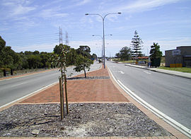
70:Looking north, in Bennett Springs
1360:
1135:
834:
777:
716:
590:
560:
555:
507:
320:, Western Australia, connecting
180:
145:
136:
27:Road in Perth, Western Australia
1:
1142:Australian Roads portal
1937:
1191:"Landgate Map Viewer Plus"
95:11.8 km (7.3 mi)
1899:
1354:
1107:
1102:Bayswater railway station
1089:
1078:
1062:
1054:
1046:
1028:
1020:
1008:
1000:
992:
979:
974:
971:
968:
965:
962:
893:
888:
880:
867:
830:
805:
801:
773:
766:
744:
736:
731:
712:
699:
694:
688:
680:
676:
654:
641:
636:
632:Ballajura railway station
627:
610:
602:
551:
526:
504:
492:
487:
482:
479:
476:
473:
470:
465:
435:Bayswater railway station
282:
217:
119:
74:
69:
60:
1112:
1081:Ashfield railway station
930:
919:
907:
898:
1195:maps.landgate.wa.gov.au
427:combination interchange
399:Ellenbrook railway line
785:(State Route 76)
515:(State Route 84)
187:(State Route 76)
1392:Beechboro Road North
1310:KML is from Wikidata
949:Beechboro Road South
568:(State Route 4)
456:Beechboro Road North
381:Beechboro Road North
368:Beechboro Road South
349:Beechboro Road North
343:Beechboro Road South
339:Beechboro Road North
222:Beechboro Road South
124:Beechboro Road North
46:Beechboro Road South
43:Beechboro Road North
18:Beechboro Road North
451:Major intersections
79:General information
273:Whatley Crescent,
185:Morley Drive East
1908:
1907:
1406:National Highways
1400:
1399:
1348:Western Australia
1273:978-0-7309-5668-6
1173:978 0 7319 2653 4
1127:
1126:
1117:Incomplete access
955:City of Bayswater
946:
945:
924:Incomplete access
783:Morley Drive East
363:Route description
311:
310:
284:
278:
248:
226:
225:
213:
188:
159:
144:interchange with
128:
127:
110:
54:Western Australia
16:(Redirected from
1928:
1387:Walter Road East
1364:
1363:
1357:
1337:
1330:
1323:
1314:
1300:
1277:
1276:
1259:
1253:
1252:
1251:
1249:
1244:, The Dept, 1993
1236:
1230:
1229:
1228:
1226:
1212:
1206:
1205:
1203:
1201:
1187:
1178:
1177:
1160:
1140:
1139:
1119:
1113:
1076:
1044:
1018:
1012:Embleton Avenue
960:
938:
931:
926:
920:
915:
908:
903:
899:
860:
844:Walter Road East
838:
837:
822:
816:
810:
799:
781:
780:
764:
720:
719:
674:
594:
593:
586:
564:
563:
559:
558:
543:
537:
531:
511:
510:
468:
463:
274:
247:
242:
219:
212:
207:
186:
184:
183:
158:
153:
149:
148:
140:
139:
121:
108:
65:
32:
21:
1936:
1935:
1931:
1930:
1929:
1927:
1926:
1925:
1911:
1910:
1909:
1904:
1895:
1744:
1448:
1432:National Routes
1427:
1401:
1396:
1379:Beaufort Street
1361:
1350:
1341:
1311:
1308:
1303:
1302:
1301:
1285:
1281:
1280:
1274:
1261:
1260:
1256:
1247:
1245:
1238:
1237:
1233:
1224:
1222:
1214:
1213:
1209:
1199:
1197:
1189:
1188:
1181:
1174:
1162:
1161:
1154:
1149:
1134:
1132:
1122:
1115:
1111:
1067:
1066:Railway Parade
1035:
1013:
951:
941:
933:
929:
922:
918:
910:
906:
901:
897:
847:
835:
818:
812:
806:
786:
778:
751:
724:(State Route 3)
717:
701:Bennett Springs
682:Bennett Springs
661:
643:Bennett Springs
591:
569:
561:
556:
539:
533:
527:
508:
458:
453:
444:
412:
401:as part of the
383:
370:
365:
265:
259:Embelton Avenue
243:
208:
191:
181:
154:
146:
137:
115:Major junctions
101:Route number(s)
56:
51:
50:
49:
38:
37:
28:
23:
22:
15:
12:
11:
5:
1934:
1932:
1924:
1923:
1913:
1912:
1906:
1905:
1900:
1897:
1896:
1894:
1893:
1888:
1883:
1878:
1873:
1868:
1863:
1858:
1853:
1848:
1843:
1838:
1833:
1828:
1823:
1818:
1813:
1808:
1803:
1798:
1793:
1788:
1783:
1778:
1773:
1768:
1763:
1758:
1752:
1750:
1749:Tourist Drives
1746:
1745:
1743:
1742:
1737:
1732:
1727:
1722:
1717:
1712:
1707:
1702:
1697:
1692:
1687:
1682:
1677:
1672:
1667:
1662:
1657:
1652:
1647:
1642:
1637:
1632:
1627:
1622:
1617:
1612:
1607:
1602:
1597:
1592:
1587:
1582:
1577:
1572:
1567:
1562:
1557:
1552:
1547:
1542:
1537:
1532:
1527:
1522:
1517:
1512:
1507:
1502:
1497:
1492:
1487:
1482:
1477:
1472:
1467:
1462:
1456:
1454:
1450:
1449:
1447:
1446:
1441:
1435:
1433:
1429:
1428:
1426:
1425:
1420:
1415:
1409:
1407:
1403:
1402:
1398:
1397:
1395:
1394:
1389:
1384:
1381:
1376:
1374:Barrack Street
1370:
1367:
1366:
1365:State Route 53
1355:
1352:
1351:
1342:
1340:
1339:
1332:
1325:
1317:
1284:
1283:
1282:
1279:
1278:
1272:
1254:
1231:
1207:
1179:
1172:
1151:
1150:
1148:
1145:
1131:
1128:
1125:
1124:
1121:
1120:
1108:
1105:
1104:
1094:
1091:
1088:
1084:
1083:
1077:
1064:
1061:
1058:
1052:
1051:
1049:Tonkin Highway
1045:
1030:
1027:
1023:
1022:
1019:
1010:
1007:
1003:
1002:
999:
994:
991:
988:
977:
976:
973:
970:
967:
964:
950:
947:
944:
943:
940:
939:
927:
916:
904:
894:
891:
890:
887:
882:
879:
876:
865:
864:
861:
832:
829:
826:
803:
802:
800:
775:
772:
768:
767:
765:
746:
743:
740:
735:
729:
728:
725:
714:
711:
708:
697:
696:
693:
690:
687:
684:
678:
677:
675:
656:
653:
650:
639:
638:
635:
629:
626:
622:
621:
615:
614:Hennessey Road
612:
609:
606:
600:
599:
596:Hepburn Avenue
587:
566:Tonkin Highway
553:
550:
547:
524:
523:
516:
505:
503:
501:
491:
485:
484:
481:
478:
475:
472:
469:
457:
454:
452:
449:
443:
442:Hennessey Road
440:
411:
408:
382:
379:
369:
366:
364:
361:
357:Hepburn Avenue
330:Tonkin Highway
314:Beechboro Road
309:
308:
295:
291:
290:
286:
285:
280:
279:
271:
267:
266:
264:
263:
260:
256:
254:
250:
249:
239:Tonkin Highway
232:
228:
227:
224:
223:
215:
214:
204:Tonkin Highway
197:
193:
192:
190:
189:
178:
173:
167:
165:
161:
160:
151:Hepburn Avenue
142:Tonkin Highway
134:
130:
129:
126:
125:
117:
116:
112:
111:
106:State Route 53
103:
97:
96:
93:
89:
88:
85:
81:
80:
76:
75:
72:
71:
67:
66:
58:
57:
52:
48:
47:
44:
40:
39:
36:Beechboro Road
35:
26:
24:
14:
13:
10:
9:
6:
4:
3:
2:
1933:
1922:
1919:
1918:
1916:
1903:
1898:
1892:
1889:
1887:
1884:
1882:
1879:
1877:
1874:
1872:
1869:
1867:
1864:
1862:
1859:
1857:
1854:
1852:
1849:
1847:
1844:
1842:
1839:
1837:
1834:
1832:
1829:
1827:
1824:
1822:
1819:
1817:
1814:
1812:
1809:
1807:
1804:
1802:
1799:
1797:
1794:
1792:
1789:
1787:
1784:
1782:
1779:
1777:
1774:
1772:
1769:
1767:
1764:
1762:
1759:
1757:
1754:
1753:
1751:
1747:
1741:
1738:
1736:
1733:
1731:
1728:
1726:
1723:
1721:
1718:
1716:
1713:
1711:
1708:
1706:
1703:
1701:
1698:
1696:
1693:
1691:
1688:
1686:
1683:
1681:
1678:
1676:
1673:
1671:
1668:
1666:
1663:
1661:
1658:
1656:
1653:
1651:
1648:
1646:
1643:
1641:
1638:
1636:
1633:
1631:
1628:
1626:
1623:
1621:
1618:
1616:
1613:
1611:
1608:
1606:
1603:
1601:
1598:
1596:
1593:
1591:
1588:
1586:
1583:
1581:
1578:
1576:
1573:
1571:
1568:
1566:
1563:
1561:
1558:
1556:
1553:
1551:
1548:
1546:
1543:
1541:
1538:
1536:
1533:
1531:
1528:
1526:
1523:
1521:
1518:
1516:
1513:
1511:
1508:
1506:
1503:
1501:
1498:
1496:
1493:
1491:
1488:
1486:
1483:
1481:
1478:
1476:
1473:
1471:
1468:
1466:
1463:
1461:
1458:
1457:
1455:
1451:
1445:
1442:
1440:
1437:
1436:
1434:
1430:
1424:
1421:
1419:
1416:
1414:
1411:
1410:
1408:
1404:
1393:
1390:
1388:
1385:
1382:
1380:
1377:
1375:
1372:
1371:
1369:
1368:
1359:
1358:
1353:
1349:
1345:
1338:
1333:
1331:
1326:
1324:
1319:
1318:
1315:
1307:
1298:
1294:
1290:
1289:
1275:
1269:
1265:
1258:
1255:
1243:
1242:
1235:
1232:
1220:
1219:
1211:
1208:
1196:
1192:
1186:
1184:
1180:
1175:
1169:
1165:
1159:
1157:
1153:
1146:
1144:
1143:
1138:
1129:
1118:
1110:
1109:
1106:
1103:
1099:
1085:
1082:
1075:
1071:
1057:
1053:
1050:
1043:
1039:
1034:
1024:
1017:
1004:
998:
986:
982:
978:
961:
958:
956:
948:
936:
928:
925:
917:
913:
905:
902:Closed/former
896:
895:
892:
886:
874:
870:
866:
859:
855:
851:
845:
841:
825:
821:
815:
809:
804:
798:
794:
790:
784:
769:
763:
759:
755:
750:
739:
734:
730:
723:
706:
702:
698:
683:
679:
673:
669:
665:
660:
659:Marshall Road
648:
644:
640:
633:
623:
619:
605:
601:
597:
585:
584:Perth Airport
581:
577:
573:
567:
546:
542:
536:
535:Cullacabardee
530:
525:
521:
514:
513:Gnangara Road
499:
498:Cullacabardee
495:
490:
486:
464:
461:
455:
450:
448:
441:
439:
436:
431:
428:
423:
419:
415:
409:
407:
404:
400:
396:
392:
386:
380:
378:
374:
367:
362:
360:
358:
354:
353:Gnangara Road
350:
346:
344:
340:
335:
331:
327:
323:
319:
315:
307:
306:Cullacabardee
303:
299:
296:
294:Major suburbs
292:
287:
281:
277:
272:
268:
261:
258:
257:
255:
251:
246:
240:
236:
233:
229:
220:
216:
211:
205:
201:
198:
194:
179:
177:
174:
172:
171:Marshall Road
169:
168:
166:
162:
157:
152:
143:
135:
131:
122:
118:
113:
107:
104:
102:
98:
94:
90:
86:
82:
77:
73:
68:
64:
59:
55:
45:
42:
41:
33:
30:
19:
1453:State Routes
1391:
1383:Broun Avenue
1286:
1263:
1257:
1246:, retrieved
1240:
1234:
1223:, retrieved
1217:
1210:
1198:. Retrieved
1194:
1163:
1133:
1114:
1068: –
1036: –
1033:Collier Road
1014: –
972:Destinations
952:
932:
921:
909:
900:
848: –
840:Broun Avenue
787: –
752: –
722:Reid Highway
662: –
570: –
520:NorthLink WA
480:Destinations
459:
445:
432:
424:
420:
416:
413:
395:Reid Highway
387:
384:
375:
371:
348:
347:
342:
338:
334:NorthLink WA
313:
312:
262:Collier Road
29:
1344:Road routes
1248:28 December
1225:28 December
1200:1 September
912:Concurrency
749:Benara Road
634:access road
391:Benara Road
289:Location(s)
176:Benara Road
1147:References
1074:Bassendean
1042:Bassendean
997:Cul-de-sac
937:transition
885:Cul-de-sac
858:Bassendean
846:eastbound
695:Roundabout
637:Roundabout
576:Ellenbrook
235:Cul-de-sac
200:Cul-de-sac
1056:Bayswater
985:Bayswater
873:Bayswater
854:Inglewood
814:Bayswater
797:Eden Hill
762:Caversham
758:Lockridge
733:Bayswater
705:Beechboro
529:Ballajura
326:Bayswater
302:Beechboro
276:Bayswater
270:South end
237:south of
231:North end
202:north of
196:South end
156:Ballajura
133:North end
1915:Category
1288:KML file
1130:See also
1098:Maylands
1070:Ashfield
987:boundary
981:Embleton
963:Location
914:terminus
875:boundary
869:Embleton
824:tripoint
820:Embleton
793:Dianella
647:Whiteman
604:Whiteman
545:tripoint
541:Whiteman
500:bonudary
471:Location
403:Metronet
245:Embleton
210:Embleton
754:Noranda
664:Warwick
410:History
1555:Alt 30
1444:Alt 94
1270:
1170:
1038:Morley
1016:Morley
808:Morley
738:Morley
707:border
672:Dayton
668:Malaga
649:border
580:Morley
572:Muchea
322:Morley
298:Morley
253:
164:
92:Length
975:Notes
935:Route
850:Perth
789:Trigg
494:Lexia
483:Notes
318:Perth
1297:help
1293:edit
1268:ISBN
1250:2013
1227:2013
1202:2020
1168:ISBN
1029:0.50
1009:0.37
628:0.99
618:LILO
611:0.19
489:Swan
324:and
87:Road
84:Type
1891:360
1886:359
1881:358
1876:357
1871:356
1866:355
1861:354
1856:353
1851:352
1846:351
1841:350
1836:259
1831:258
1826:257
1821:256
1816:255
1811:254
1806:252
1801:251
1796:250
1791:207
1786:206
1781:205
1776:204
1771:203
1766:202
1761:201
1756:200
1740:139
1735:138
1730:136
1725:123
1720:120
1715:116
1710:115
1705:107
1700:104
1695:102
1346:in
1090:1.6
1087:2.5
1063:1.5
1060:2.4
1026:0.8
1006:0.6
993:0.0
881:4.2
878:6.7
831:3.9
828:6.3
774:3.5
771:5.7
745:2.5
742:4.1
713:1.7
710:2.7
689:1.4
686:2.3
655:1.2
652:1.9
625:1.6
608:0.3
552:0.0
549:0.0
467:LGA
1917::
1690:87
1685:85
1680:84
1675:83
1670:82
1665:81
1660:78
1655:77
1650:76
1645:75
1640:72
1635:71
1630:66
1625:65
1620:64
1615:61
1610:60
1605:56
1600:55
1595:53
1590:52
1585:51
1580:50
1575:41
1570:40
1565:36
1560:31
1550:30
1545:27
1540:26
1535:22
1530:21
1525:20
1520:19
1515:18
1510:14
1505:13
1500:12
1495:10
1423:95
1418:94
1295:•
1193:.
1182:^
1155:^
1072:,
1040:,
969:mi
966:km
957:.
856:,
852:,
795:,
791:,
760:,
756:,
670:,
666:,
582:,
578:,
574:,
477:mi
474:km
345:.
304:,
300:,
241:,
206:,
1490:8
1485:7
1480:6
1475:5
1470:4
1465:3
1460:2
1439:1
1413:1
1336:e
1329:t
1322:v
1299:)
1291:(
1204:.
1176:.
990:0
983:–
871:–
817:–
811:–
703:–
645:–
538:–
532:–
496:–
20:)
Text is available under the Creative Commons Attribution-ShareAlike License. Additional terms may apply.