218:
349:
acres (6.1 ha) bought by the State Board of
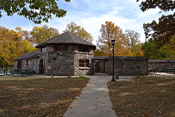
Conservation in 1935. A causeway was created on top of the old dike. The bathhouse was built between 1935 and 1936, and a footbridge was built in 1937. The beach adjacent to the bathhouse was completed in October 1936. The boulders for the spillway and bathhouse construction came from adjacent fields. Other minor structures, which include a flagstone walk and roadways, are also considered historic and were built by the CCC. The park officially opened on June 5, 1938. The non-contributing structures were all built after the CCC's involvement.
1742:
36:
64:
71:
43:
594:
348:
The CCC worked from 1934 to 1938 developing the park. They set up camp in the
Franklin County Fairgrounds. The dam and spillway were constructed between 1934 and 1936. They began filling the lake by August 1937. Five fish rearing ponds were created from 1936 to 1937 to the east of the lake on 15
335:
Springbrook Creek was dammed and a sawmill was built in 1857. A flour mill was established two years later. The property was bought by
William Beed in 1864 and he continued the operation until 1903-1904. The dike washed-out between 1910 and 1913, and the mill was taken down in 1916. The following
340:
desired to create a 120-acre (49 ha) lake as early as 1926. They were able to buy options for 254 acres (103 ha) in 1933. The City of
Hampton and several civic organizations bought the property the following year and presented it to the State of Iowa. The city requested that the
1838:
1833:
327:, and five non-contributing structures. The 319-acre (129 ha) park surrounds a 99-acre (40 ha) reservoir. It features hiking trails, boating, fishing, swimming, camping, picnic areas and shelters, lodges and concessions.
1818:
1770:
1843:
812:
1813:
1696:
576:
1654:
1828:
561:
324:
320:
1808:
472:
1701:
1731:
1798:
1793:
1248:
1774:
1647:
63:
35:
107:
1706:
551:
493:
308:
204:
1640:
520:
571:
528:
465:
1803:
1741:
1663:
1622:
862:
642:
566:
481:
406:
312:
195:
952:
556:
371:
174:
1453:
1223:
1078:
802:
667:
637:
1691:
927:
787:
697:
502:
217:
1721:
1213:
1128:
458:
1383:
1323:
1218:
1158:
1138:
1048:
717:
546:
510:
376:
1458:
1183:
1178:
1108:
1010:
772:
1378:
1478:
1468:
1373:
1313:
1303:
1283:
1273:
1203:
1098:
917:
902:
872:
732:
1268:
1243:
1233:
1193:
1823:
1413:
1408:
1358:
1173:
1083:
1025:
912:
682:
262:
1393:
1263:
1163:
1073:
1068:
1448:
1363:
1253:
1198:
1148:
1038:
882:
832:
342:
1463:
1418:
1133:
1123:
1088:
1043:
907:
792:
1526:
1473:
1428:
1403:
1398:
1328:
1318:
1208:
1143:
1433:
1423:
1343:
1288:
1258:
1228:
1188:
962:
852:
797:
737:
652:
627:
1438:
1338:
1278:
1168:
1093:
1601:
1388:
1238:
1118:
1113:
1103:
1015:
980:
807:
1632:
1606:
1368:
1333:
1153:
1053:
1033:
1541:
1506:
1497:
1483:
1353:
1298:
1293:
995:
762:
707:
692:
619:
538:
1591:
1581:
1566:
1551:
1058:
990:
1521:
366:
1711:
1596:
1546:
1536:
937:
932:
867:
777:
752:
742:
722:
1571:
1531:
1756:
1576:
1556:
1443:
975:
947:
922:
892:
842:
822:
767:
757:
702:
1516:
1716:
1667:
1348:
1005:
985:
887:
847:
837:
817:
747:
727:
672:
662:
433:
411:
94:
1586:
1561:
1063:
942:
857:
657:
1726:
1686:
1000:
970:
687:
632:
337:
255:
877:
610:
827:
782:
677:
429:
267:
1308:
897:
712:
319:
in 1990. At the time of its nomination it contained 21 resources, which included one
280:
1787:
304:
1839:
Park buildings and structures on the
National Register of Historic Places in Iowa
599:
589:
122:
109:
450:
1834:
Historic districts on the
National Register of Historic Places in Iowa
1771:
National
Register of Historic Places listings in Franklin County, Iowa
401:
485:
336:
year the 40-acre (16 ha) mill pond was drained. The local
1732:
St. John's Danish
Evangelical Lutheran Church Historic District
1636:
454:
1819:
National
Register of Historic Places in Franklin County, Iowa
1844:
Parks on the
National Register of Historic Places in Iowa
430:"Beeds Lake State Park, Civilian Conservation Corps Area"
1682:
Beeds Lake State Park, Civilian Conservation Corps Area
317:
Beeds Lake State Park, Civilian Conservation Corps Area
1749:
1674:
1505:
1496:
1024:
961:
618:
609:
537:
519:
501:
492:
345:(CCC) develop a 258.68-acre (104.68 ha) park.
286:
273:
261:
251:
243:
235:
227:
170:
162:
154:
146:
138:
101:
90:
23:
1814:Buildings and structures in Franklin County, Iowa
1697:Franklin County G. A. R. Soldiers' Memorial Hall
1648:
466:
70:
42:
8:
1702:Franklin County Sheriff's Residence and Jail
1829:Historic districts in Franklin County, Iowa
1775:List of National Historic Landmarks in Iowa
1655:
1641:
1633:
1502:
615:
498:
473:
459:
451:
216:
50:Location of Beed's Lake State Park in Iowa
20:
196:U.S. National Register of Historic Places
78:Beeds Lake State Park (the United States)
1809:Protected areas of Franklin County, Iowa
1707:Hampton Double Square Historic District
423:
421:
358:
402:"National Register Information System"
396:
394:
268:CCC Properties in Iowa State Parks MPS
307:, United States. It was listed has a
7:
1664:National Register of Historic Places
1623:Iowa Department of Natural Resources
407:National Register of Historic Places
313:National Register of Historic Places
166:Iowa Department of Natural Resources
89:
1799:Civilian Conservation Corps in Iowa
1794:Protected areas established in 1934
372:Geographic Names Information System
16:State park in Franklin County, Iowa
14:
1740:
1722:Reeve Electric Association Plant
592:
188:Civilian Conservation Corps Area
69:
62:
41:
34:
813:Mines of Spain & E.B. Lyons
377:United States Geological Survey
153:
275:
1:
1224:Iowa's State Preserves System
81:Show map of the United States
1214:Indian Bluffs Primitive Area
1804:Rustic architecture in Iowa
1384:Saint James Lutheran Church
562:Northern Tallgrass Prairie
343:Civilian Conservation Corps
247:Central Design Office, Ames
231:79.89 acres (32.33 ha)
1860:
1692:Franklin County Courthouse
1049:Behrens Pond and Woodlands
150:1,135 ft (346 m)
1765:
1738:
1619:
643:Banner Lakes at Summerset
587:
539:National Wildlife Refuges
294:
274:NRHP reference
215:
211:
202:
193:
184:
180:
28:
1179:Freda Haffner Kettlehole
1109:Cedar Hills Sand Prairie
303:is located northwest of
252:Architectural style
1712:Dr. O.B. Harriman House
1469:Wittrock Indian Village
1379:Rolling Thunder Prairie
577:Upper Mississippi River
325:contributing structures
142:319 acres (129 ha)
1757:Herman Wood Round Barn
521:National Historic Site
205:U.S. Historic district
186:Beeds Lake State Park,
1717:Maysville Schoolhouse
1668:Franklin County, Iowa
1374:Roggman Boreal Slopes
1314:Nestor Stiles Prairie
1304:Mount Pisgah Cemetery
1284:Merrill A. Stainbrook
1274:Marietta Sand Prairie
434:National Park Service
412:National Park Service
321:contributing building
301:Beeds Lake State Park
123:42.77028°N 93.25444°W
97:, Iowa, United States
24:Beeds Lake State Park
1269:Mann Wilderness Area
1244:Liska-Stanek Prairie
1234:Kish-Ke-Kosh Prairie
1194:Hardin City Woodland
718:George Wyth Memorial
1824:State parks of Iowa
1727:Leander Reeve House
1687:H.E. Boehmler House
1454:Turkey River Mounds
1409:Silvers-Smith Woods
773:Lake of Three Fires
338:Izaak Walton League
163:Governing body
128:42.77028; -93.25444
119: /
1264:Manikowski Prairie
1164:Five Ridge Prairie
1074:Brush Creek Canyon
1069:Bluffton Fir Stand
873:Preparation Canyon
1781:
1780:
1630:
1629:
1615:
1614:
1492:
1491:
1459:White Pine Hollow
1449:Turin Loess Hills
1444:Toolesboro Mounds
1364:Rock Creek Island
1254:Malanaphy Springs
1149:Doolittle Prairie
1129:Cold Water Spring
1039:Ames High Prairie
1011:White Pine Hollow
683:Dolliver Memorial
585:
584:
503:National monument
309:historic district
298:
297:
290:November 15, 1990
1851:
1744:
1657:
1650:
1643:
1634:
1503:
1464:Williams Prairie
1324:Old State Quarry
1249:Little Maquoketa
1219:Indian Fish Trap
1159:Fish Farm Mounds
1139:Decorah Ice Cave
1134:Crossman Prairie
1124:Claybanks Forest
1044:Anderson Prairie
833:Palisades-Kepler
616:
602:
597:
596:
595:
499:
475:
468:
461:
452:
445:
444:
442:
440:
425:
416:
415:
398:
389:
388:
386:
384:
379:. April 30, 1979
363:
277:
220:
134:
133:
131:
130:
129:
124:
120:
117:
116:
115:
112:
82:
73:
72:
66:
54:
53:Show map of Iowa
45:
44:
38:
21:
1859:
1858:
1854:
1853:
1852:
1850:
1849:
1848:
1784:
1783:
1782:
1777:
1761:
1745:
1736:
1670:
1661:
1631:
1626:
1611:
1607:Three Mile Lake
1509:
1488:
1474:Woodland Mounds
1429:Stinson Prairie
1404:Silver Lake Fen
1399:Sheeder Prairie
1329:Palisades-Downs
1319:Ocheyedan Mound
1209:Hoffman Prairie
1184:Gitchie Manitou
1144:Dinesen Prairie
1026:State Preserves
1020:
957:
853:Pillsbury Point
798:Maquoketa Caves
788:Lewis and Clark
738:Lacey-Keosauqua
628:Ambrose A. Call
605:
598:
593:
591:
581:
533:
515:
488:
482:Protected areas
479:
449:
448:
438:
436:
427:
426:
419:
414:. July 9, 2010.
400:
399:
392:
382:
380:
365:
364:
360:
355:
333:
223:
207:
198:
189:
187:
127:
125:
121:
118:
113:
110:
108:
106:
105:
86:
85:
84:
83:
80:
79:
76:
75:
74:
57:
56:
55:
52:
51:
48:
47:
46:
17:
12:
11:
5:
1857:
1855:
1847:
1846:
1841:
1836:
1831:
1826:
1821:
1816:
1811:
1806:
1801:
1796:
1786:
1785:
1779:
1778:
1766:
1763:
1762:
1760:
1759:
1753:
1751:
1747:
1746:
1739:
1737:
1735:
1734:
1729:
1724:
1719:
1714:
1709:
1704:
1699:
1694:
1689:
1684:
1678:
1676:
1672:
1671:
1662:
1660:
1659:
1652:
1645:
1637:
1628:
1627:
1620:
1617:
1616:
1613:
1612:
1610:
1609:
1604:
1599:
1594:
1589:
1584:
1579:
1574:
1569:
1564:
1559:
1554:
1549:
1544:
1542:Frank A. Gotch
1539:
1534:
1529:
1524:
1519:
1513:
1511:
1500:
1494:
1493:
1490:
1489:
1487:
1486:
1481:
1479:Woodman Hollow
1476:
1471:
1466:
1461:
1456:
1451:
1446:
1441:
1436:
1434:Strasser Woods
1431:
1426:
1424:Steele Prairie
1421:
1416:
1411:
1406:
1401:
1396:
1394:Searryl's Cave
1391:
1386:
1381:
1376:
1371:
1366:
1361:
1356:
1351:
1346:
1341:
1336:
1331:
1326:
1321:
1316:
1311:
1306:
1301:
1296:
1291:
1289:Merritt Forest
1286:
1281:
1276:
1271:
1266:
1261:
1259:Malchow Mounds
1256:
1251:
1246:
1241:
1236:
1231:
1226:
1221:
1216:
1211:
1206:
1204:Hayden Prairie
1201:
1196:
1191:
1186:
1181:
1176:
1171:
1166:
1161:
1156:
1151:
1146:
1141:
1136:
1131:
1126:
1121:
1116:
1111:
1106:
1101:
1099:Cayler Prairie
1096:
1091:
1086:
1081:
1076:
1071:
1066:
1061:
1056:
1051:
1046:
1041:
1036:
1030:
1028:
1022:
1021:
1019:
1018:
1013:
1008:
1003:
998:
993:
988:
983:
978:
973:
967:
965:
959:
958:
956:
955:
950:
945:
940:
935:
930:
925:
920:
915:
910:
905:
900:
895:
890:
885:
880:
875:
870:
865:
863:Pleasant Creek
860:
855:
850:
845:
840:
835:
830:
825:
820:
815:
810:
808:McIntosh Woods
805:
800:
795:
790:
785:
780:
775:
770:
765:
760:
755:
750:
745:
740:
735:
730:
725:
720:
715:
710:
705:
700:
695:
690:
685:
680:
675:
670:
665:
660:
655:
650:
645:
640:
635:
630:
624:
622:
613:
607:
606:
604:
603:
588:
586:
583:
582:
580:
579:
574:
569:
564:
559:
554:
552:Driftless Area
549:
543:
541:
535:
534:
532:
531:
529:Herbert Hoover
525:
523:
517:
516:
514:
513:
507:
505:
496:
490:
489:
480:
478:
477:
470:
463:
455:
447:
446:
417:
390:
357:
356:
354:
351:
332:
329:
296:
295:
292:
291:
288:
284:
283:
278:
271:
270:
265:
259:
258:
253:
249:
248:
245:
241:
240:
237:
233:
232:
229:
225:
224:
221:
213:
212:
209:
208:
203:
200:
199:
194:
191:
190:
185:
182:
181:
178:
177:
172:
168:
167:
164:
160:
159:
156:
152:
151:
148:
144:
143:
140:
136:
135:
103:
99:
98:
92:
88:
87:
77:
68:
67:
61:
60:
59:
58:
49:
40:
39:
33:
32:
31:
30:
29:
26:
25:
15:
13:
10:
9:
6:
4:
3:
2:
1856:
1845:
1842:
1840:
1837:
1835:
1832:
1830:
1827:
1825:
1822:
1820:
1817:
1815:
1812:
1810:
1807:
1805:
1802:
1800:
1797:
1795:
1792:
1791:
1789:
1776:
1772:
1769:
1764:
1758:
1755:
1754:
1752:
1748:
1743:
1733:
1730:
1728:
1725:
1723:
1720:
1718:
1715:
1713:
1710:
1708:
1705:
1703:
1700:
1698:
1695:
1693:
1690:
1688:
1685:
1683:
1680:
1679:
1677:
1673:
1669:
1665:
1658:
1653:
1651:
1646:
1644:
1639:
1638:
1635:
1625:
1624:
1618:
1608:
1605:
1603:
1600:
1598:
1595:
1593:
1592:Sharon Bluffs
1590:
1588:
1585:
1583:
1582:Oakland Mills
1580:
1578:
1575:
1573:
1570:
1568:
1567:Margo Frankel
1565:
1563:
1560:
1558:
1555:
1553:
1552:Lake Cornelia
1550:
1548:
1545:
1543:
1540:
1538:
1535:
1533:
1530:
1528:
1525:
1523:
1520:
1518:
1515:
1514:
1512:
1508:
1504:
1501:
1499:
1495:
1485:
1482:
1480:
1477:
1475:
1472:
1470:
1467:
1465:
1462:
1460:
1457:
1455:
1452:
1450:
1447:
1445:
1442:
1440:
1439:Sylvan Runkel
1437:
1435:
1432:
1430:
1427:
1425:
1422:
1420:
1417:
1415:
1414:Slinde Mounds
1412:
1410:
1407:
1405:
1402:
1400:
1397:
1395:
1392:
1390:
1387:
1385:
1382:
1380:
1377:
1375:
1372:
1370:
1367:
1365:
1362:
1360:
1359:Roberts Creek
1357:
1355:
1352:
1350:
1347:
1345:
1342:
1340:
1339:Pellett Woods
1337:
1335:
1332:
1330:
1327:
1325:
1322:
1320:
1317:
1315:
1312:
1310:
1307:
1305:
1302:
1300:
1297:
1295:
1292:
1290:
1287:
1285:
1282:
1280:
1279:Mericle Woods
1277:
1275:
1272:
1270:
1267:
1265:
1262:
1260:
1257:
1255:
1252:
1250:
1247:
1245:
1242:
1240:
1237:
1235:
1232:
1230:
1227:
1225:
1222:
1220:
1217:
1215:
1212:
1210:
1207:
1205:
1202:
1200:
1197:
1195:
1192:
1190:
1187:
1185:
1182:
1180:
1177:
1175:
1174:Fort Atkinson
1172:
1170:
1169:Fleming Woods
1167:
1165:
1162:
1160:
1157:
1155:
1152:
1150:
1147:
1145:
1142:
1140:
1137:
1135:
1132:
1130:
1127:
1125:
1122:
1120:
1117:
1115:
1112:
1110:
1107:
1105:
1102:
1100:
1097:
1095:
1094:Catfish Creek
1092:
1090:
1087:
1085:
1084:Cameron Woods
1082:
1080:
1077:
1075:
1072:
1070:
1067:
1065:
1062:
1060:
1057:
1055:
1052:
1050:
1047:
1045:
1042:
1040:
1037:
1035:
1032:
1031:
1029:
1027:
1023:
1017:
1014:
1012:
1009:
1007:
1004:
1002:
999:
997:
994:
992:
989:
987:
984:
982:
979:
977:
974:
972:
969:
968:
966:
964:
963:State Forests
960:
954:
953:Wilson Island
951:
949:
946:
944:
941:
939:
936:
934:
931:
929:
926:
924:
921:
919:
916:
914:
911:
909:
908:Trapper's Bay
906:
904:
901:
899:
896:
894:
891:
889:
886:
884:
881:
879:
876:
874:
871:
869:
866:
864:
861:
859:
856:
854:
851:
849:
846:
844:
841:
839:
836:
834:
831:
829:
826:
824:
821:
819:
816:
814:
811:
809:
806:
804:
801:
799:
796:
794:
791:
789:
786:
784:
781:
779:
776:
774:
771:
769:
766:
764:
763:Lake Macbride
761:
759:
756:
754:
751:
749:
746:
744:
741:
739:
736:
734:
731:
729:
726:
724:
721:
719:
716:
714:
711:
709:
708:Fort Defiance
706:
704:
701:
699:
696:
694:
693:Elinor Bedell
691:
689:
686:
684:
681:
679:
676:
674:
671:
669:
666:
664:
661:
659:
656:
654:
651:
649:
646:
644:
641:
639:
636:
634:
631:
629:
626:
625:
623:
621:
617:
614:
612:
608:
601:
590:
578:
575:
573:
570:
568:
565:
563:
560:
558:
555:
553:
550:
548:
545:
544:
542:
540:
536:
530:
527:
526:
524:
522:
518:
512:
511:Effigy Mounds
509:
508:
506:
504:
500:
497:
495:
491:
487:
483:
476:
471:
469:
464:
462:
457:
456:
453:
435:
431:
428:Joyce McKay.
424:
422:
418:
413:
409:
408:
403:
397:
395:
391:
378:
374:
373:
368:
362:
359:
352:
350:
346:
344:
339:
330:
328:
326:
322:
318:
314:
310:
306:
305:Hampton, Iowa
302:
293:
289:
287:Added to NRHP
285:
282:
279:
272:
269:
266:
264:
260:
257:
254:
250:
246:
242:
238:
234:
230:
226:
219:
214:
210:
206:
201:
197:
192:
183:
179:
176:
173:
169:
165:
161:
157:
149:
145:
141:
137:
132:
104:
100:
96:
93:
65:
37:
27:
22:
19:
1767:
1681:
1621:
1527:Crystal Lake
1522:Cold Springs
1419:Starr's Cave
1389:Savage Woods
1309:Mount Talbot
1239:Lamson Woods
1199:Hartley Fort
1119:Clay Prairie
1114:Cheever Lake
1104:Cedar Bluffs
1089:Casey's Paha
1079:Brushy Creek
1016:Yellow River
938:Wapsipinicon
933:Walnut Woods
868:Prairie Rose
803:Marble Beach
778:Lake Wapello
753:Lake Darling
743:Lake Ahquabi
723:Green Valley
668:Brushy Creek
647:
638:Badger Creek
572:Union Slough
437:. Retrieved
405:
381:. Retrieved
370:
367:"Beeds Lake"
361:
347:
334:
316:
300:
299:
18:
1597:Spring Lake
1557:Lake Icaria
1547:Heery Woods
1537:Echo Valley
1507:State Parks
1369:Rock Island
1344:Pilot Grove
1334:Pecan Grove
1189:Hanging Bog
1154:Fallen Rock
1054:Berry Woods
1034:A.F. Miller
996:Pilot Mound
991:Loess Hills
948:Wildcat Den
928:Volga River
923:Viking Lake
918:Union Grove
893:Springbrook
843:Pikes Point
828:Okamanpedan
823:Nine Eagles
768:Lake Manawa
758:Lake Keomah
733:Honey Creek
698:Emerson Bay
620:State Parks
600:Iowa portal
567:Port Louisa
175:iowadnr.gov
155:Established
126: /
102:Coordinates
1788:Categories
1750:Iowa Falls
1572:Mill Creek
1532:Eagle Lake
1484:Woodthrush
1354:Retz Woods
1349:Pilot Knob
1299:Mossy Glen
913:Twin Lakes
888:Rock Creek
848:Pilot Knob
838:Pikes Peak
818:Mini-Wakan
748:Lake Anita
728:Gull Point
678:Clear Lake
673:Cedar Rock
663:Black Hawk
648:Beeds Lake
557:Neal Smith
353:References
114:93°15′16″W
111:42°46′13″N
1768:See also:
1602:Swan Lake
1577:Oak Grove
1059:Bird Hill
943:Waubonsie
883:Rice Lake
858:Pine Lake
793:Lower Gar
658:Big Creek
244:Architect
239:1934-1938
222:Bathhouse
147:Elevation
1517:Bobwhite
1510:(Leased)
1006:Stephens
971:Backbone
703:Fairport
688:Elk Rock
653:Bellevue
633:Backbone
439:April 6,
383:April 7,
281:90001672
95:Franklin
91:Location
1675:Hampton
1294:Montauk
981:Gifford
976:Barkley
903:Templar
878:Red Haw
494:Federal
331:History
311:on the
171:Website
1587:Pammel
1562:Kearny
1498:County
1229:Kalsow
1001:Shimek
783:Ledges
547:DeSoto
256:Rustic
1064:Bixby
986:Holst
898:Stone
713:Geode
611:State
323:, 15
236:Built
1773:and
486:Iowa
441:2016
385:2016
228:Area
158:1934
139:Area
1666:in
484:of
315:as
276:No.
263:MPS
1790::
432:.
420:^
410:.
404:.
393:^
375:.
369:.
1656:e
1649:t
1642:v
474:e
467:t
460:v
443:.
387:.
Text is available under the Creative Commons Attribution-ShareAlike License. Additional terms may apply.