106:
388:
376:
73:
709:
38:
53:
113:
80:
348:
The village was first mentioned in 1435 as "van der Beetze", and means "low lying (often flooded in the winter) land". Beets developed in the late 13th century on the southern part of the
Beetskoog
578:
690:
769:
750:
571:
105:
774:
548:
564:
197:
289:
141:
784:
301:
779:
743:
588:
360:
Beets was home to 412 people in 1840. Until 1970, Beets was a separate municipality. In 2016, it became part of the municipality of
72:
736:
387:
375:
281:
185:
357:
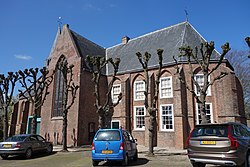
The Dutch
Reformed church is a single aisled cruciform church from the 15th century. It was restored in 1873 and 1961.
173:
556:
497:
260:
52:
270:
37:
663:
606:
720:
416:
320:
708:
763:
716:
592:
361:
333:
329:
202:
190:
325:
178:
647:
156:
143:
679:
467:
251:
658:
642:
611:
637:
632:
652:
350:
277:
256:
522:
337:
441:
560:
125:
Location in the province of North
Holland in the Netherlands
496:
Ronald
Stenvert & Saskia van Ginkel-Meester (2006).
724:
691:
List of cities, towns and villages in North
Holland
672:
620:
599:
300:
288:
267:
250:
242:
234:
229:
221:
213:
208:
196:
184:
172:
21:
744:
572:
8:
751:
737:
579:
565:
557:
491:
489:
18:
517:
515:
336:, and lies about 9 km southwest of
403:
371:
287:
249:
228:
220:
207:
171:
136:
64:
46:
34:
770:Former municipalities of North Holland
411:
409:
407:
328:. It is a part of the municipality of
549:Repertorium van Nederlandse gemeenten
319:
299:
266:
241:
233:
212:
195:
183:
16:Village in North Holland, Netherlands
7:
705:
703:
417:"Kerncijfers wijken en buurten 2021"
547:Ad van der Meer and Onno Boonstra,
217:4.05 km (1.56 sq mi)
723:. You can help Knowledge (XXG) by
14:
775:Populated places in North Holland
707:
386:
374:
324:) is a village in the northwest
111:
104:
78:
71:
51:
36:
448:(in Dutch). Het Waterschapshuis
446:Actueel Hoogtebestand Nederland
1:
785:North Holland geography stubs
468:"Beets - (geografische naam)"
112:
79:
500:(in Dutch). Zwolle: Waanders
421:Central Bureau of Statistics
92:Location in the Netherlands
801:
780:Geography of Edam-Volendam
702:
225:−0.5 m (−1.6 ft)
688:
442:"Postcodetool for 1475AA"
137:
128:Show map of North Holland
65:
47:
35:
28:
587:Populated places in the
246:130/km (350/sq mi)
95:Show map of Netherlands
719:location article is a
269: • Summer (
317:Dutch pronunciation:
243: • Density
157:52.58917°N 4.97750°E
153: /
235: • Total
214: • Total
732:
731:
697:
696:
310:
309:
162:52.58917; 4.97750
792:
753:
746:
739:
711:
704:
581:
574:
567:
558:
552:
545:
539:
538:
536:
534:
519:
510:
509:
507:
505:
493:
484:
483:
481:
479:
464:
458:
457:
455:
453:
438:
432:
431:
429:
427:
413:
390:
378:
323:
321:[ˈbeːts]
318:
274:
168:
167:
165:
164:
163:
158:
154:
151:
150:
149:
146:
129:
115:
114:
108:
96:
82:
81:
75:
55:
40:
19:
800:
799:
795:
794:
793:
791:
790:
789:
760:
759:
758:
757:
700:
698:
693:
684:
668:
616:
595:
585:
555:
546:
542:
532:
530:
521:
520:
513:
503:
501:
495:
494:
487:
477:
475:
466:
465:
461:
451:
449:
440:
439:
435:
425:
423:
415:
414:
405:
401:
394:
391:
382:
379:
370:
346:
316:
296:
268:
161:
159:
155:
152:
147:
144:
142:
140:
139:
133:
132:
131:
130:
127:
126:
123:
122:
121:
120:
116:
99:
98:
97:
94:
93:
90:
89:
88:
87:
83:
61:
60:
59:
58:
43:
42:Church of Beets
31:
24:
17:
12:
11:
5:
798:
796:
788:
787:
782:
777:
772:
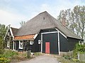
762:
761:
756:
755:
748:
741:
733:
730:
729:
712:
695:
694:
689:
686:
685:
683:
682:
676:
674:
670:
669:
667:
666:
661:
656:
650:
645:
640:
635:
630:
624:
622:
618:
617:
615:
614:
609:
603:
601:
597:
596:
586:
584:
583:
576:
569:
561:
554:
553:
551:, KNAW, 2011.
540:
511:
485:
472:Etymologiebank
459:
433:
402:
400:
397:
396:
395:
392:
385:
383:
380:
373:
369:
366:
345:
342:
308:
307:
304:
298:
297:
294:
292:
286:
285:
275:
265:
264:
254:
248:
247:
244:
240:
239:
236:
232:
231:
227:
226:
223:
219:
218:
215:
211:
210:
206:
205:
200:
194:
193:
188:
182:
181:
176:
170:
169:
135:
134:
124:
118:
117:
110:
109:
103:
102:
101:
100:
91:
85:
84:
77:
76:
70:
69:
68:
67:
66:
63:
62:
56:
50:
49:
48:
45:
44:
41:
33:
32:
29:
26:
25:
22:
15:
13:
10:
9:
6:
4:
3:
2:
797:
786:
783:
781:
778:
776:
773:
771:
768:
767:
765:
754:
749:
747:
742:
740:
735:
734:
728:
726:
722:
718:
717:North Holland
713:
710:
706:
701:
692:
687:
681:
678:
677:
675:
671:
665:
662:
660:
657:
654:
651:
649:
646:
644:
641:
639:
636:
634:
631:
629:
626:
625:
623:
619:
613:
610:
608:
605:
604:
602:
598:
594:
593:Edam-Volendam
590:
582:
577:
575:
570:
568:
563:
562:
559:
550:
544:
541:
528:
524:
518:
516:
512:
499:
492:
490:
486:
473:
469:
463:
460:
447:
443:
437:
434:
422:
418:
412:
410:
408:
404:
398:
393:Farm in Beets
389:
384:
381:Farm in Beets
377:
372:
367:
365:
363:
362:Edam-Volendam
358:
355:
353:
352:
343:
341:
339:
335:
334:North Holland
331:
330:Edam-Volendam
327:
322:
314:
305:
303:
293:
291:
283:
279:
276:
272:
262:
258:
255:
253:
245:
237:
224:
216:
204:
203:Edam-Volendam
201:
199:
192:
191:North Holland
189:
187:
180:
177:
175:
166:
138:Coordinates:
107:
74:
54:
39:
27:
20:
725:expanding it
714:
699:
627:
589:municipality
543:
531:. Retrieved
527:Plaatsengids
526:
502:. Retrieved
476:. Retrieved
471:
462:
450:. Retrieved
445:
436:
424:. Retrieved
420:
359:
356:
349:
347:
312:
311:
302:Dialing code
198:Municipality
57:Coat of arms
655:(partially)
326:Netherlands
290:Postal code
179:Netherlands
160: /
764:Categories
648:Oosthuizen
529:(in Dutch)
474:(in Dutch)
399:References
230:Population
145:52°35′21″N
680:Etersheim
252:Time zone
222:Elevation
148:4°58′39″E
659:Schardam
643:Middelie
621:Villages
612:Volendam
533:29 April
504:29 April
478:29 April
452:29 April
426:29 April
186:Province
673:Hamlets
638:Kwadijk
633:Hobrede
523:"Beets"
498:"Beets"
368:Gallery
344:History
174:Country
30:Village
664:Warder
653:Purmer
351:polder
715:This
628:Beets
600:Towns
338:Hoorn
313:Beets
278:UTC+2
257:UTC+1
119:Beets
86:Beets
23:Beets
721:stub
607:Edam
535:2022
506:2022
480:2022
454:2022
428:2022
306:0299
295:1475
282:CEST
209:Area
591:of
271:DST
261:CET
238:540
766::
525:.
514:^
488:^
470:.
444:.
419:.
406:^
364:.
354:.
340:.
332:,
752:e
745:t
738:v
727:.
580:e
573:t
566:v
537:.
508:.
482:.
456:.
430:.
315:(
284:)
280:(
273:)
263:)
259:(
Text is available under the Creative Commons Attribution-ShareAlike License. Additional terms may apply.