45:
267:
29:
52:
79:
176:
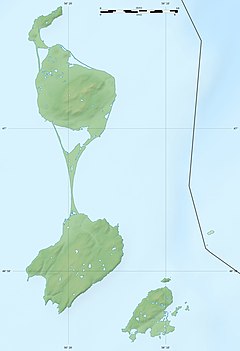
that connects the two northern and southern "islands" of
Miquelon and Langlade, respectively. The river is fed by several streams and ponds on Langlade, and flows northwest for the majority of its length. The river's course turns northeast shortly before emptying into the sea on the eastern side of
44:
219:
308:
337:
123:
327:
301:
332:
342:
294:
194:
274:
165:
94:
161:
266:
28:
169:
240:
278:
321:
198:
106:
33:
The community of Anse du
Gouverneur, with the mouth of the Belle River visible
138:
125:
173:
84:
51:
168:. The river flows through the archipelago's largest island of
282:
177:the island in the community of Anse du Gouverneur.
172:, which is formed by a thin strip of land called a
115:
105:
100:
90:
72:
67:
21:
302:
8:
309:
295:
16:River in Saint Pierre and Miquelon, France
220:"St. Pierre and Miquelon Geological Map"
338:Non-metropolitan France geography stubs
186:
197:. www.elevationmap.net. Archived from
18:
7:
263:
261:
328:Rivers of Saint Pierre and Miquelon
160:is the largest river in the French
14:
265:
243:. www.britannica.com. 2020-09-10
77:
50:
43:
27:
333:Saint Pierre and Miquelon stubs
117: • coordinates
1:
343:North America geography stubs
101:Physical characteristics
281:. You can help Knowledge by
241:"Saint-Pierre and Miquelon"
359:
260:
275:Saint Pierre and Miquelon
166:Saint Pierre and Miquelon
95:Saint Pierre and Miquelon
38:
26:
195:"Langlade Elevation Map"
277:location article is a
162:overseas collectivity
139:46.89657°N 56.29940°W
144:46.89657; -56.29940
135: /
222:. BRGM. 2015-05-01
290:
289:
170:Miquelon-Langlade
154:
153:
59:Location of mouth
350:
311:
304:
297:
269:
262:
252:
251:
249:
248:
237:
231:
230:
228:
227:
216:
210:
209:
207:
206:
191:
150:
149:
147:
146:
145:
140:
136:
133:
132:
131:
128:
83:
81:
80:
54:
53:
47:
31:
19:
358:
357:
353:
352:
351:
349:
348:
347:
318:
317:
316:
315:
258:
256:
255:
246:
244:
239:
238:
234:
225:
223:
218:
217:
213:
204:
202:
193:
192:
188:
183:
143:
141:
137:
134:
129:
126:
124:
122:
121:
118:
78:
76:
63:
62:
61:
60:
57:
56:
55:
34:
17:
12:
11:
5:
356:
354:
346:
345:
340:
335:
330:
320:
319:
314:
313:
306:
299:
291:
288:
287:
270:
254:
253:
232:
211:
185:
184:
182:
179:
152:
151:
119:
116:
113:
112:
109:
103:
102:
98:
97:
92:
88:
87:
74:
70:
69:
65:
64:
58:
49:
48:
42:
41:
40:
39:
36:
35:
32:
24:
23:
15:
13:
10:
9:
6:
4:
3:
2:
355:
344:
341:
339:
336:
334:
331:
329:
326:
325:
323:
312:
307:
305:
300:
298:
293:
292:
286:
284:
280:
276:
271:
268:
264:
259:
242:
236:
233:
221:
215:
212:
201:on 2021-02-06
200:
196:
190:
187:
180:
178:
175:
171:
167:
163:
159:
148:
120:
114:
110:
108:
104:
99:
96:
93:
89:
86:
75:
71:
66:
46:
37:
30:
25:
20:
283:expanding it
272:
257:
245:. Retrieved
235:
224:. Retrieved
214:
203:. Retrieved
199:the original
189:
157:
155:
158:Belle River
142: /
22:Belle River
322:Categories
247:2021-01-31
226:2021-01-31
205:2021-01-31
181:References
130:56°17′58″W
127:46°53′48″N
91:Territory
68:Location
174:tombolo
73:Country
111:
85:France
82:
273:This
107:Mouth
279:stub
156:The
164:of
324::
310:e
303:t
296:v
285:.
250:.
229:.
208:.
Text is available under the Creative Commons Attribution-ShareAlike License. Additional terms may apply.