45:
329:
343:
376:
507:
116:
512:
471:
277:
rises on the southwestern slopes of the range and then flows north around the northern end and then turns south flowing parallel to the eastern side.
435:
502:
44:
201:
405:
356:
200:
listed wet tropical forests, including species of flora and fauna endemic to the range. The range also forms part of the
109:
258:
286:
278:
213:
231:(922 m) (one of the highest free-standing natural pyramids in the world) is located at the range's northern end .
254:
209:
193:
20:
460:
467:
205:
182:
431:
384:
306:
298:
178:
174:
302:
244:
224:
197:
186:
24:
248:
220:
63:
281:
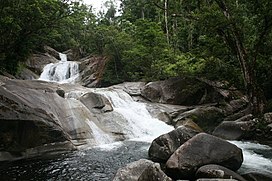
drains the southeast parts of the range. A number of waterfalls cascade off the range including
348:
334:
262:
314:
290:
294:
282:
274:
228:
170:
148:
496:
409:
310:
324:
240:
131:
118:
253:. Lieutenant Phillip King named the range after the English botanist
208:
because it supports populations of a range of bird species endemic to
70:
243:
but weren't given the name "Bellenden Ker Range" before
Lieutenant
257:, following the suggestion made to him by his ships own botanist,
212:. Most of the range is also a gazetted protected area named
19:
This article is about the mountain range. For the town, see
406:"Wet Tropics Management Authority World Heritage Area maps"
147:
108:
100:
92:
84:
79:
69:
59:
54:
32:
247:named them, on 22 June 1819, whilst aboard the
432:"Important Bird Areas factsheet: Wooroonooran"
49:Josephine Falls in Wooroonooran National Park.
8:
29:
239:The mountains were sighted by Lieutenant
192:The whole of the range falls within the
368:
16:Mountain range in Queensland, Australia
227:(1593 m) form part of this range, and
477:from the original on 18 February 2011
455:
453:
7:
265:was an early explorer of the range.
219:Queensland's two highest mountains,
508:Important Bird Areas of Queensland
377:"Bellenden Ker Range (entry 2184)"
14:
513:Landforms of Far North Queensland
196:and is covered in richly diverse
438:from the original on 11 May 2018
434:. BirdLife International. 2011.
341:
327:
202:Wooroonooran Important Bird Area
43:
194:Wet Tropics World Heritage Area
357:List of mountains in Australia
1:
503:Mountain ranges of Queensland
461:"Cairns Heritage: B Suburbs"
75:1,622 m (5,322 ft)
529:
214:Wooroonooran National Park
18:
255:John Bellenden Ker Gawler
177:, Australia. Part of the
42:
37:
21:Bellenden Ker, Queensland
210:Queensland's Wet Tropics
204:, identified as such by
23:. For the mountain, see
468:Cairns Regional Council
381:Queensland Place Names
206:BirdLife International
181:it is located between
385:Queensland Government
412:on 12 September 2009
179:Great Dividing Range
175:Far North Queensland
165:, also known as the
155:Great Dividing Range
104:Far North Queensland
245:Phillip Parker King
225:Mount Bellenden Ker
163:Bellenden Ker Range
128: /
25:Mount Bellenden Ker
307:Silver Creek Falls
221:Mount Bartle Frere
167:Wooroonooran Range
132:17.233°S 145.867°E
64:Mount Bartle Frere
55:Highest point
349:Queensland portal
159:
158:
110:Range coordinates
520:
487:
486:
484:
482:
476:
465:
457:
448:
447:
445:
443:
428:
422:
421:
419:
417:
408:. Archived from
402:
396:
395:
393:
391:
373:
351:
346:
345:
344:
337:
335:Mountains portal
332:
331:
330:
263:Archibald Meston
259:Allan Cunningham
151:
143:
142:
140:
139:
138:
137:-17.233; 145.867
133:
129:
126:
125:
124:
121:
47:
30:
528:
527:
523:
522:
521:
519:
518:
517:
493:
492:
491:
490:
480:
478:
474:
463:
459:
458:
451:
441:
439:
430:
429:
425:
415:
413:
404:
403:
399:
389:
387:
375:
374:
370:
365:
347:
342:
340:
333:
328:
326:
323:
315:Clamshell Falls
299:Wallicher Falls
291:Josephine Falls
271:
237:
149:
136:
134:
130:
127:
122:
119:
117:
115:
114:
50:
28:
17:
12:
11:
5:
526:
524:
516:
515:
510:
505:
495:
494:
489:
488:
449:
423:
397:
367:
366:
364:
361:
360:
359:
353:
352:
338:
322:
319:
303:Nandroya Falls
295:Tchupala Falls
283:Kearneys Falls
275:Mulgrave River
270:
267:
236:
233:
229:Walshs Pyramid
198:world heritage
171:mountain range
157:
156:
153:
145:
144:
112:
106:
105:
102:
98:
97:
94:
90:
89:
86:
82:
81:
77:
76:
73:
67:
66:
61:
57:
56:
52:
51:
48:
40:
39:
35:
34:
15:
13:
10:
9:
6:
4:
3:
2:
525:
514:
511:
509:
506:
504:
501:
500:
498:
473:
469:
462:
456:
454:
450:
437:
433:
427:
424:
411:
407:
401:
398:
386:
382:
378:
372:
369:
362:
358:
355:
354:
350:
339:
336:
325:
320:
318:
316:
312:
308:
304:
300:
296:
292:
288:
287:Fishery Falls
284:
280:
279:Russell River
276:
268:
266:
264:
260:
256:
252:
251:
246:
242:
234:
232:
230:
226:
223:(1622 m) and
222:
217:
215:
211:
207:
203:
199:
195:
190:
188:
184:
180:
176:
172:
169:is a coastal
168:
164:
154:
152:
146:
141:
113:
111:
107:
103:
99:
95:
91:
87:
83:
78:
74:
72:
68:
65:
62:
58:
53:
46:
41:
36:
33:Bellenden Ker
31:
26:
22:
479:. Retrieved
440:. Retrieved
426:
414:. Retrieved
410:the original
400:
388:. Retrieved
380:
371:
311:Whites Falls
272:
249:
238:
218:
191:
166:
162:
160:
150:Parent range
38:Wooroonooran
135: /
497:Categories
481:16 October
363:References
241:James Cook
183:Gordonvale
96:Queensland
88:Australia
80:Geography
71:Elevation
472:Archived
436:Archived
321:See also
123:145°52′E
390:21 June
250:Mermaid
235:History
187:Babinda
120:17°14′S
85:Country
442:11 May
416:11 May
313:, and
269:Rivers
101:Region
475:(PDF)
464:(PDF)
93:State
483:2010
444:2018
418:2018
392:2017
273:The
185:and
161:The
60:Peak
173:in
499::
470:.
466:.
452:^
383:.
379:.
317:.
309:,
305:,
301:,
297:,
293:,
289:,
285:,
261:.
216:.
189:.
485:.
446:.
420:.
394:.
27:.
Text is available under the Creative Commons Attribution-ShareAlike License. Additional terms may apply.