663:
south-west edge of the park. Eastern quolls inhabit the ski village during winter, and are sometimes sighted during daylight hours. Dusky antechinus occasionally visit lodges. The echidna has been recorded and the platypus has been sighted in the Upper Ford River. Various other species, including the long-nosed potoroo, Tasmanian bettong, brushtail possum, ringtail possum, sugar glider, native rodents such as the velvet-furred rat and the long-tailed mouse, and six species of bat have all been recorded in the park. Among the birds, no systematic study has been made. Wedge-tailed eagles are regularly reported, as is the noisy yellow-tailed black cockatoo. Among the endemic species recorded are the green rosella, scrubtit, brown thornbill, yellow wattlebird, yellow-throated honeyeater, black-headed honeyeater, strong-billed honeyeater and the black currawong. Little is known of the reptiles from Ben Lomond. Of particular interest is the endemic northern snow skink
Niveoscincus greeni which is an alpine species restricted to several other mountain top areas in the State. Amphibians recorded from Ben Lomond include the brown tree frog, common eastern froglet and the endemic Tasmanian froglet.
654:
moorland to dense forest. A total of 222 plant species have been recorded on the Ben Lomond plateau, represented by 152 dicotyledons, 62 monocotyledons, 1 gymnosperm and 7 fern and fern ally families. The five most common families (Asteraceae, Poaceae, Epacridaceae, Cyperaceae and
Proteaceae) account for about half the total number of species recorded. Most families, however, are only represented by one or two species. Some introduced plants have naturalised on the plateau from introduced grasses, clovers and straw used to stabilise soil and revegetate areas affected by slope grooming, road works and other site disturbances. The most common native species recorded on the plateau are the herbs Poa gunnii (tussock grass) and Gentianella diemensis, the shrubs, Richea scoparia, Orites acicularis and Pentachondra pumila, Baeckea gunniana and Epacris serpyllifolia. Cushion plants are abundant throughout the plateau. One species, the rock cushion plant Chionohebe ciliolata, is known only from a small localised area within the Park. Other rare and threatened species include the rare endemic Oreomyrrhis sessiliflora, and the endangered Colobanthus curtisiae.
706:(now Longford). Initial contact between the Ben Lomond people and British settlers was likely to have been on hunting grounds around the South or North Esk, as early in settlement hunting parties from Launceston made incursions into the plains south of the nascent city. First contact may well have been peaceable as convict hunters and aboriginal people traded kangaroos and hunting dogs early in the colony's history. Into the 1820s free land grants to wealthy settlers displaced convict hunters and led to the establishment of pastoralism at the Ben Lomond frontier, particularly up the Nile and Esk Rivers. The presence of farms and stockmen interrupted the migratory tribal life of the Aborigines and, although initial relations were peaceable, displacement was accelerated by continuing intrusion into country, abduction of aboriginal women and violent conflict with both settlers and with rival tribes. In particular, women became scarce due to the abduction by sealers of women in coastal areas, consequently leading to internecine raids for women across the interior.
847:
labour. A Full survey of Ben Lomond was conducted from
September 1905 to 1912 by Colonel W.V. Legge and, later, Lyndhurst Giblin took over the survey. The surveyors climbed to the plateau from Mangana but on some of the later visits they ascended via Avoca and the Ben Lomond Marshes. The nomenclature of features on the mountain were established at this time and were named after members of the survey party and famous explorers of the period. The survey party explored the highlands on the north of the plateau in 1907. Legge had long suspected that the north of the plateau was higher than the trigonometric station on Stacks Bluff (called by him Ben Lomond Fell or Bluff) but was less obviously elevated. Moreover, the area was, at the time, an area so remote and unexplored that Legge described it as 'untrodden as the distant ranges of the west coast'. Lyndhurst Giblin climbed and measured the true summit and named it after Legge. and, in turn, the prominent bluff to the south of the summit was named for Giblin's father - Giblin Fells.
637:
Plateau. This exposure includes a narrow coal sequence, which was once worked commercially. During the
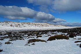
Pleistocene Ice Age, a small ice-cap existed on Ben Lomond, which was the only plateau in the north-east to be glaciated. The effects of these glaciers account for much of the contrast between the alpine scenery of Ben Lomond and that of the other mountains in the north-east. The most notable relict periglacial depositional features are the blockfields, which cover over a quarter of the Ben Lomond plateau. Much of the plateau is devoid of soils. Organic soils (peats), including deep peats, are most extensively developed on the western side of Rodway Valley. Mineral soils are also found, particularly in the better drained sites.
697:
around the headwaters of the South Esk River near modern day
Mathinna. There are also signs of regular occupation of the plateau by the Plangermaireener; artifacts such as stone tools are found about the low dunes at the eastern aspect of Lake Youl and in colonial times soldiers pursuing the Plangermaireener noted the 'native track' up onto the plateau from the foothills and remarked at the extensive evidence of summer occupation - with remains of firing seen about the plateau. Moreover, the remains of Aboriginal quarry works under Coalmine Crag suggest that the plateau was used for sustained periods by the Plangermaireener, as stone tools were needed for dressing game.
934:
597:. There is no isolated peak named Ben Lomond but instead the name may refer to the plateau, massif, bioregion or national park in which it is situated. In colonial times 'Ben Lomond' referred to both the southern extremity of the massif and the country around the southern escarpment. The toponym does not appear cartographically in reference to the entire massif until the 1900s; when Stacks Bluff also appeared on modern maps. Features on the plateau have accreted names over the last two centuries as the region has opened up to surveyors and official parties.
970:
185:
1074:
685:
Tonenerweenerlarmenne. The
Plangermaireener clan is recorded as variously inhabiting the south-east aspect of the Ben Lomond region and also has been associated with the coastal tribes to the south-east. This clan was likely to have occupied the region of the modern day Fingal Valley to the St Mary's Plains and east coast region. 'Plangermaireener' is also used as a blanket term for all the members of the Ben Lomond Nation which reflects the suffix 'mairener', recorded as meaning 'people' or 'tribe'.
641:
966:
village. The island peak Ragged Jack has established walking and climbing routes that are accessed via the north west foothills. The southern access is from Storys Creek, past
Tranquil Tarn, to the northern slopes of Stacks Bluff. A track leads up to the summit cairn of Stacks Bluff, which affords extensive views of the entire eastern half of Tasmania. The plateau is relatively open walking but no other marked tracks exist, although guide books describe access to various features on the plateau.
942:
track to the plateau lay across the Ben Lomond
Marshes ascending the western side of Stacks Bluff. This track led from Avoca, up Castle Cary Rivulet to the Ben Lomond Marshes, to the plateau on the western side of Stacks Bluff and along the headwaters of the Ben Lomond Rivulet. The track was describes as passing up the 'Ploughed Fields' (the scree slope below Stacks Bluff) and proceeding through a pass between Wilmot Bluff and the western cliff line called by locals 'The Gap'.
760:
party of clansmen were raiding up the South Esk Valley. The raiding party attacked several remote settler and stockman's huts from Oyster Bay to Avoca - alongside their traditional hunting and travelling route on the Ben Lomond frontier. Their aim appeared to be both robbery and revenge and during their raids they killed 5 assigned men and wounded several others severely, reportedly only being prevented from killing an entire family by the presence of soldiers.
178:
950:
plateau (complete with stables) and was regarded as an easy ascent to the plateau
Another steep track existed from Storys Creek which is still used to ascend via Tranquil Tarn to the summit of Stack's Bluff. The western face of Ben Lomond was accessed from English Town and this track took a course round the northern slopes of Ragged Jack. This is the original route for access for skiers before the northern route was established from Carr Villa hut.
3438:
804:. Mannarlargenna has been praised for attempting to preserve the remnants of his people with his bargain or treaty with Arthur and Robinson. It would ultimately lead to the end of hostilities with the Aboriginal people, although at the expense of exile, as the remnant aboriginal people were moved en masse to Wybalenna ('Black Man's Houses' in the Ben Lomond Nation language) on Flinder's Island - where Mannarlargenna died of pneumonia.
926:
915:
69:
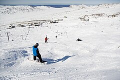
1018:, the village is at 1,460 metres (4,790 ft) and the top elevation is 1,570 metres (5,150 ft). A number of club lodges provide accommodation and the mountain has fine views which stretch to the ocean. In 2010, the Department of Parks and Wildlife released a plan for the Ben Lomond ski area recommending snow making machines, the enhancement of snow play areas and the development of a possible snow board park.
4432:
1060:
604:(originally 'the Butts', then 'the Stacks'), Ossians Throne (originally 'The Knuckle'), the Buffaloes (rock formations near Denison Crag) and Ragged Jack (originally Ragged Mountain) appearing in correspondence in the 1800s. Features on the plateau were predominantly named after surveyors (Giblin Fells), Government Administrators (Twelvetrees Moor), local identities Lake Youl (
264:
732:; the same day they threw a spear at Mr. Sinclair’s shepherd; the spear passed over the man’s shoulder and through a ewe about two rods before him, which the man was driving. The man escaped by running from them. Last Saturday, week they speared and beat with their waddies a man of Mr. Reed’s, near the same spot. Yesterday they attacked a servant of Mr Sevoir's
1088:
812:; the son of Rolepana, a Ben Lomond Nation elder became the first Australian Aboriginal activist when he petitioned Queen Victoria in 1846 in protest at the treatment of his people. The aboriginal people fared poorly at Wybalenna and then when relocated to Oyster Cove, with disease and malnutrition contributing to high mortality and low birth rates.
667:
816:
died with them. The Palawa did not die out- descendants of the 'tyreelore', Palawa women taken as wives by sealers in Bass Strait, continued to live in a prosperous community on
Flinders and Cape Barren Islands. Many of these descendants have cultural and genetic lineage from the Ben Lomond Nation and with the chief Mannarlargenna, in particular.
954:
382:, 1,527 metres (5,010 ft), which is an imposing feature that drops away to a cliffline 600 metres (2,000 ft) above the surrounding foothills. The prominent outlier peaks of Ragged Jack (1,369 metres (4,491 ft)), Mensa Moor (1,358 metres (4,455 ft)) and Tower Hill (1,122 metres (3,681 ft)) surround the plateau.
995:
permanent summit hut was constructed 4 years later to allow skiers to overnight on the summit. A smaller hut was constructed at the head of the pass to the plateau for the purposes of shelter and storage of ski gear. The remains of this hut can be seen from the walking track as it crests the pass into the Borrowdale Valley.
861:
Mathinna and Mangana from 1855 until the 1940s. At its peak Mathinna had a population of 2000 but this dwindled after mining ceased. Tin and tungsten were the other minerals to be obtained in the southern foothills of Ben Lomond and the townships of Rossarden and Storys Creek arose from the 1920s to 1957 around these mines.
874:) and the seams are exposed and easily accessible in the vicinity of Raffertys Creek and Coalmine Crag. Coal was found in commercial quantities at the head of the Ben Lomond Rivulet in 1857 but the seam was mined at the Stanhope Mine, situated on Buffalo Brook about halfway between Stacks Bluff and Avoca.
965:
Today, formed tracks exist that access the plateau from the northern, northeastern and south-eastern aspects of the massif. The northern access track is from the Scout hut at Carr Villa, in the northern foothills, to the summit (following the snow pole line of the old ski track) and thence to the ski
941:
Recreational walking on and around the plateau was established from at least the mid 1830s, usually for the purpose of summiting Stacks Bluff, but it was not until the 1880s, when the mines had brought large numbers into the area, that walking on the plateau became popular. At this time the principal
869:
In 1829, coal deposits were found by a British party, led by Batman, which was pursuing a group of Plangermaireener onto the plateau. The party collected coal which was successfully burnt after descending from the mountain. Later, a seam was excavated on the plateau, at Coalmine Crag, from which coal
829:
The first European to ascend the mountain was likely to have been Batman, who is recorded to have crossed the plateau in his forays against the Ben Lomond Nation. In 1829, with a party of soldiers, he ascended the plateau from the foothills, noting the 'native track' onto the summit and the extensive
759:
The latter half of 1830 saw an increase in frontier violence as the Black War reached its nadir. During the spring of 1830 an Aboriginal party was noted to have crossed the Midlands from the 'Westward' to the Ben Lomond frontier and, within a fortnight, Batman reported in a dispatch that a marauding
546:
Most of the Aboriginal names for Ben Lomond probably refer to Stacks Bluff or the southern division of the massif - as the toponym Ben Lomond was usually applied to the southern half of the mountain in 1800s Tasmania, when these words were recorded. The lake on the southern aspect of the plateau, now
990:
Their route was by way of English Town, Ragged Jack and the headwaters of River O'Plain Creek (see image). This route had the disadvantage that it involved an extended walk to get onto the plateau but was less steep than the alternative access from Blessington. The northern route was subsequently
846:
on 28 November 1841 and he measured the height of Stacks Bluff (albeit incorrectly) by barometry as 5002 feet. In 1852; after the site was surveyed by James Sprent, the Government Surveyor, a Trigonometric Point was constructed on Stacks Bluff (the southernmost extremity of Ben Lomond) using convict
833:
The artist John Glover ascended the mountain with Batman in the 1833 accompanied by the surveyor John Wedge and Batman's mainland aboriginal servants. Glover made sketches that clearly show the bluffs on the south-eastern escarpment, views of Lake Youl and the view of Tranquil Tarn from the eastern
705:
The clans of the Ben Lomond Nation were displaced in the early 1800s by extensive colonial occupation up the South Esk river and its tributaries. This particularly manifested along the mountain's western and northern boundaries, which lay closest to the settled areas of Launceston and Norfolk Plains
692:
The location of the Tonenerweenerlarmenne is uncertain but were probably centred in the remaining Ben Lomond Nation territory from White Hills to the headwaters of the North and South-Esk rivers or the upper South-Esk Valley. This notwithstanding, the Palawa were a nomadic people and likely occupied
636:
The basement rocks comprise slates, siltstones, greywackes and quartzite. These were intruded by granite and, later, by dolerite during the Jurassic Period. Dolerite predominates on the plateau. The only exception is a highly localised area under Coalmine Crag and around the flanks of the Ben Lomond
998:
Access to Carr Villa, at 900m elevation, was by foot until a road was constructed in 1959 but then the summit was still a 500m ascent on foot from this point. Carr Villa chalet is now operated by the Rover Scouts after it was donated by NTAC in 1963 and the skiers access track is part of the Legges
791:
announced on 14 March 1831 his new policy of the removal of Aborigines from Tasmania. The conciliator George Augustus Robinson was tasked with rounding up the remnant aboriginal people. Robinson "....gave an unequivocal commitment that if hostilities ceased, Aborigines would be protected and have
778:
Attacks on colonials decreased after the military action of the Black Line but in early 1831 three assigned men of Thomas Massey were wounded by Aboriginal clansmen near modern day Deddington and this is the last reported conflict between settlers and Aboriginal clansmen at the Ben Lomond frontier.
716:
Over time, the aboriginal people were forced into an ever more marginal existence and; with numbers depleted by disease, murder and abduction, were forced into sustained conflict with occupying settlers. In 1829 these remnants of the Ben Lomond nation allied with members of the North Midland nation
709:
In 1825 two convicts assigned to Andrew Barclay and James Cox on the Nile River, near Deddington, were killed and mutilated by Ben Lomond clanspeople in a dispute over women and ownership of hunting dogs. An aboriginal witness, Temina, testified that one man was killed by spearing and that a woman
1002:
In 1950 a Parliamentary Standing Committee recommended that Ben Lomond be developed as a ski resort. The Australian National Championships were held at the site in 1955. In 1963 the access road was extended to the top of the plateau via the steep and scenic "Jacobs Ladder". Subsequent developments
961:
Excursions in the 1880s became popular enough for a landowner to build a two-storey hotel with 12 rooms, a store, bakehouse and stables at the northern end of the Ben Lomond Marshes for the use of excursionists and miners. This was the 'Ben Lomond Hotel', which was built in 1883, and was a popular
815:
The Ben Lomond Nation ceased to exist as a political and cultural entity after the occupation of their country and the subsequent murder, abduction or exile of its people. When the last people of that nation died at Oyster Cove on the Derwent much of the history that had persisted for generations
747:
the colonial government authorised the employment of Roving Parties (essentially armed bounty hunters) to conciliate the remaining free aboriginal tribesmen. In September 1829, a party led by Batman, with the assistance of two mainland aboriginal men he had brought to Tasmania, and the Tasmanian
653:
Ben Lomond National Park protects a representative cross-section of Tasmania's north-east alpine plant communities. Although much of the plateau is stony with areas of low and often stunted forms of vegetation, the remainder of the mountain contains a wide variety of habitats ranging from alpine
900:
Proposals for Ben Lomond to be made a scenic reserve were made as early as 1910 - as a reaction to frequent fires on the plateau. Ben Lomond was declared a National Park and Scenic Reserve in July 1947. The park encompassed nearly 40,000 acres of land that had previously been declared a fauna
751:
This must have proven to be a devastating setback to an increasingly desperate remnant of the Plangermaireener as they were scarcely seen on the Ben Lomond frontier from that time. Remnant Plangermaireener women were subsequently found in the Piper River region and reported lethal internecine
696:
The clans of the Ben Lomond Nation hunted along the valleys of the South Esk and North Esk rivers, their tributaries and the highlands to the northeast; as well as making forays to the plateau in summer. There are records of aboriginal huts or dwellings around the foothills of Stacks Bluff and
949:
A track from Mangana was created in the early 20th century for the purposes of attracting walking tourists onto the plateau. The summit was '9 miles from Mangana', led up the eastern escarpment and was used later by Legge for his survey of the mountain. This track passed by a hut below the
860:
In 1854 exploratory parties seeking gold, and sponsored by the Colonial Government, explored the plateau of Ben Lomond, driving bores and claiming to find 'particles of gold' But it was alluvial gold, below the summit, that proved payable and was mined to the east of Ben Lomond at Tower Hill,
994:
In 1932, a chalet was built under the northern escarpment, facilitating access to the summit ski slopes. This chalet was named 'Carr Villa' - named from a sign taken from the Carr Villa cemetery tram stop in Launceston - humorously celebrating a Mr Carr, a member of the ski club. The first
763:
However, by late 1830, remnants of the Aboriginal clans were living a precarious existence on the edge of the frontier, harried by alert colonial settlers and militia and denied access to their hunting grounds. As the infamous 'Black Line' military operation was being disbanded elsewhere in
986:
formed in 1929 and pioneered trips to the mountain and improved the access track. In July 1929 Fred Smithies, a pioneer of skiing on Ben Lomond, accompanied the Tasmanian government's Tourism Director on a field trip to the plateau with the aim of establishing the feasibility of a skifield.
807:
At Wybalenna the remnant of the Ben Lomond people were encamped with aboriginal people from other, often rival, nations. The process of cultural assimilation began here, with compulsory attendance at Christian services mandated. At Wybalenna aboriginal people continued their resistance to
662:
Of the larger mammals, Bennett's wallabies and wombats are common, and are regularly seen in the ski village during summer and winter, even under blizzard conditions. Pademelons are abundant in the wet gullies and areas with thick undergrowth. Forester kangaroos have been recorded along the
684:
The original inhabitants of the area were the people of the Ben Lomond Nation, which consisted of at least three clans totalling 150–200 people. Three clan names are known but their locations are somewhat conjectural - the clans were recorded as Plangermaireener, Plindermairhemener and
400:
Its accessibility from Launceston, together with the existence of a ski village on the plateau make Ben Lomond an all year round favourite for tourists and hikers. Access to the village and summit can be made via several walking tracks or via a zig-zag road known as "Jacobs Ladder".
620:)" - John Batman's mainland Aboriginal guide; all of whom accompanied Wedge on his first expedition to the plateau. Wedge also records an unknown feature (possibly Lake Baker, the next largest water feature on the plateau) as 'Lake Maikai' - the provenance of this name is unknown.
688:
The Plindermairhemener clan is associated with the south and south-western aspects of the region and are likely to have occupied the South Esk Valley from the Avoca region up to at least the Nile River. Their country was bordered by the South Esk River to the south and west.
792:
their essential needs met by the government while being able to live and hunt within their own districts." These concessions, combined with the promised return of their women from the sealers, were the terms under which the chief Mannalargenna joined Robinson's embassy.
555:
possibly referring to the surrounding topography. This name survives on modern maps as the toponym for the small lakes on the north-western aspect of the plateau - the Menamatta Tarns. One of the few examples in Tasmania of a land feature retaining its traditional name.
962:
staging point for the walk up to the plateau, but by 1908 the hotel had been abandoned and fallen into disrepair. The Ben Lomond Hotel continued to be used as a staging hut for guided excursions up to the plateau from Avoca into the 20th century.
748:
Aborigine 'Black Bill' Ponsonby, led an attack on an Aboriginal family group together numbering 60–70 men, women and children in the mountain's south east foothills. Waiting until 11pm that night before attacking - 'killing or wounding 15'.
1003:
have included new ski lifts, visitor facilities, a licensed inn and accommodation, sewerage system, and improved access. The Ben Lomond Skifield Management Authority was formed in 1995 to manage the Skifield Development Area.
870:
was extracted for local use in the ski village and, possibly, by trappers. It is not known whether the Aboriginal inhabitants of the region used this coal for burning or decoration but there is an indigenous word for coal (
755:
In winter 1830 the Ben Lomond people were noted to be absent from their traditional wintering grounds on the East Coast and never again would family groups be seen collecting eggs and fish from the lagoons at Oyster Bay.
3244:
946:, being located on the Fingal train line from Launceston, was the staging point for excursions to the mountain, with local guides arranging packhorses, camping equipment and suitable campsites below the plateau.
882:
Mining interests also existed on the north-west of the mountain, around the island peak of Ragged Jack, where the prospect of silver and tin was investigated, but they proved to be economically unviable.
891:
Loch Leven trout fry were released into Lake Youl in 1905 in an attempt to establish recreational fishing on the mountain. Recent survey of fauna on the mountain shows no evidence of fish in Lake Youl.
713:
Children, also, were a target for abduction by settlers. For example, the prominent settler James Cox, at Clarendon on the Nile River, raised the Aboriginal William 'Black Bill' Ponsonby from a child.
796:
was either a Plangermaireener or Oyster Bay Chief (or perhaps a leader of a confederation of the two Nations) - an Aboriginal leader who had organised guerrilla attacks against British settlers in
1030:
and is featured as a cycling destination in itself. Mountain-bikers enjoy the fire trails around the mountain, commercial downhill rides down Jacobs Ladder and a multisport event in the vicinity.
768:
spent a week in north-east Tasmania searching without success for the Ben Lomond people. By this time, Robinson considered that the Plangermaireener were reduced to just 10 individuals.
736:), whom they endeavoured to surround ; the man saved his life by discharging his musket two or three times, and retreating every time until he got to his hut where other men were"
2000:
593:
on his circumnavigation of Tasmania, the modern name was given by Colonel Paterson, who founded the first settlement in northern Tasmania in 1804, and is taken from the eponymous
1859:
3708:
4476:
3487:
710:
belonging to his people 'crushed his head with stones'.'. This was the first recorded of many violent encounters between the Plangermaireener and European settlers.
752:
conflict between the Ben Lomond people and a confederation of Oyster Bay and Big River clansmen - resulting in the death of all but 6 of the Plangermairreener men.
3095:
3851:
743:
in July and in the next month spearing of assigned men at Lord's property, killing a stonemason in his employ. As hostilities escalated across Tasmania in the
2170:
775:
and he subsequently sent a party searching throughout the Northeast looking for the remnants of the Ben Lomond, and north-eastern peoples, without success.
3675:
3222:
3733:
4461:
374:
above 1,200 metres (3,900 ft) and high outlier peaks projecting from the mountain. The highest feature on the plateau is the unimposing summit of
3743:
3701:
834:
face. Although no paintings of the ascent have survived there was at least one painting exhibited in 1835 that portrayed the summit of Ben Lomond.
113:
2622:
3293:
3346:
1814:
2730:
3860:
3365:
2011:
1224:
1103:
1038:
The locality has an area of 182.6 square kilometres (70.5 sq mi), almost all of which is occupied by the Ben Lomond National Park.
720:"The black natives have again commenced their outrages in this district. About six weeks back they speared a shepherd belonging to Mr. Dark (
3480:
2401:
991:
selected after a suitable route was found through the help of a local farmer, beginning from the Upper Blessington road at Wattle Corner.
3694:
739:
These attacks continued on huts and farms along the Ben Lomond frontier into 1829, with a war party plundering a stock hut belonging to
2081:
1866:
3065:
2426:
1903:
3844:
3402:
2356:
2316:
2269:
2217:
2065:
2043:
1842:
1254:
3818:
1631:
177:
3473:
1734:
3039:
2652:
1755:
1448:
4456:
4435:
3768:
3753:
2834:
2630:
4471:
3837:
3738:
3641:
3103:
106:
2373:
4193:
3778:
3717:
3670:
3591:
2378:(1970 (Johnson Reprint Corp); Reprint of 1884 ed.). London; New York: Sampson, Low Marston, Searle and Rivington.
933:
463:
means bluff or precipitous cliffs. Modern etymological researchers of the Palawa lexicon assert that, in addition to
38:
3274:. Placenames Tasmania. Select “Search”, enter "38088R", click “Search”, select row, map is displayed, click “Details”
2971:
1046:
The C432 route (Ben Lomond Road) enters from the north-west and runs south-east to a skiing village, where it ends.
983:
4481:
4219:
3793:
3763:
3596:
3441:
600:
The prominent peaks were renamed promptly by European settlers and most were based on appearance or location, with
4235:
4074:
3989:
3798:
3773:
3525:
409:
969:
4466:
4399:
4376:
4066:
3808:
3788:
3783:
3758:
3728:
3585:
1271:
1015:
765:
4368:
4308:
4279:
3803:
3748:
616:'Lake Glover' - after John Glover - and named modern day Tranquil Tarn as 'Pigeon's Well'; - after "Pigeon (
4227:
4050:
4042:
3125:
1137:
772:
241:
94:
2454:
4259:
4243:
4151:
3575:
99:
640:
3447:
3300:
1619:. Hobart, Tasmania: Commonwealth of Australia Department of Parks, Wildlife and Heritage. p. 101.
4291:
3813:
3580:
1275:
1143:
1132:
1011:
809:
797:
429:
386:
378:, at 1572 m, on the northern aspect of the plateau. The southern end of the plateau is dominated by
285:
263:
31:
1316:
1314:
1312:
1310:
842:
The first scientific visit to the Ben Lomond plateau was made by the Polish explorer Paul Edmond de
728:
stock hut of blankets, flour, sugar, etc. Three days after they pursued a shepherd of Mr. Massey’s (
4116:
3562:
3520:
2737:
787:
After the failure of the 'Black Line' in 1830, and after pressure from settlers, Colonial Governor
229:
2926:
4127:
1921:
1108:
623:
Last to be named is Mensa Moor, which was approved by the state Nomenclature Board in the 1990s.
605:
417:
413:
394:
901:
reserve although land already set aside for the Forestry Commission was excluded from the park.
30:
This article is about the mountain, the locality, and the national park. For the bioregion, see
4170:
4162:
3547:
3398:
3361:
3342:
2466:
2422:
2397:
2352:
2312:
2265:
2213:
2061:
2039:
1909:
1899:
1838:
1810:
1730:
1420:
1250:
1220:
1182:
1026:
Jacobs Ladder has been made notorious as the steep training ground for Tour de France cyclist
609:
3201:
4208:
4182:
3601:
3299:. Department of Primary Industries, Parks, Water & Environment. May 2017. Archived from
2526:
1079:
1065:
617:
590:
522:- South Esk River) a contraction for the plains to the south of Stacks Bluff - Fingal Valley
3460:
3073:
4316:
3943:
3900:
3535:
3502:
1933:
1247:
Friendly mission: the Tasmanian journals and papers of George Augustus Robinson, 1829-1834
943:
843:
724:, in sight of that gentlemen’s house... About a week after that they robbed Mr. Bonney’s (
560:
3025:
459:
is thought to denote tableland or plateau and linguistic research suggests that the stem
416:
region of Tasmania. The locality is about 64 kilometres (40 mi) east of the town of
3437:
3176:
2109:
17:
4407:
3607:
3515:
3386:
The Tasmanian Tribes and Cicatrices as Tribal Indicators among the Tasmanian Aborigines
1792:
The Tasmanian Tribes and Cicatrices as Tribal Indicators among the Tasmanian Aborigines
925:
914:
68:
1399:
1157:
4450:
4357:
4001:
3540:
3453:
1952:
1093:
1007:
793:
788:
390:
3043:
1543:
830:
firing of the plateau by the Plangermaireener from their regular summer occupation.
551:, the prefix mena/miena being the aboriginal word for lake or lagoon and the suffix
4415:
4336:
4324:
4251:
4139:
4058:
4034:
4026:
4018:
3957:
3882:
3829:
3649:
3631:
3570:
2660:
1763:
1452:
1113:
1027:
601:
379:
4105:
4097:
4086:
3935:
3395:
Friendly Mission: The Tasmanian journals and diaries of George Augustus Robinson
3249:
2553:
1974:
953:
937:
Jacob's ladder single lane access road to Mount Ben Lomond in Tasmania Australia
740:
608:(clergyman)) or contemporary explorers (Grant Cirque). The Government Surveyor
432:
153:
54:
2916:
Daily Telegraph (Launceston). A Christmas Trip to Ben Lomond. 10 February 1900.
1219:. Launceston: N. J. B. Plomley in association with the Government of Tasmania.
3927:
3510:
2869:
2855:
Daily Telegraph (Launceston). A Christmas Trip to Ben Lomond. 10 February 1900
1656:
1055:
918:
594:
375:
3686:
3151:
2600:
2470:
1913:
1593:
1571:
128:
115:
3872:
2826:
973:
Clive French, from the Launceston Walking Club, skating on Lake Youl c. 1950
801:
771:
In December 1830, Robinson had relocated 33 Tasmanian Aboriginals to nearby
744:
217:
2531:
1711:(2 ed.). Hobart, Tasmania: The Royal Society of Tasmania. p. 75.
1696:(2 ed.). Hobart, Tasmania: The Royal Society of Tasmania. p. 64.
583:, that is, the Fingal valley. The river near modern day Nile was known as
3866:
3618:
360:
356:
246:
234:
213:
198:
3271:
1727:
The Abels: a comprehensive guide to Tasmania's mountains over 1100m high
480:- the plateau between the Nile River valley (Lake Youl) and Stacks Bluff
3665:
3552:
3530:
3465:
2104:
2102:
666:
371:
3011:
2082:"ms 3251 1825-31 box 1 vol 4: "Black Natives" - also Paton vs Gregson"
1010:
operations are located at Ben Lomond, 60 kilometres (37 mi) from
331:
367:
84:
2515:"A history of discovery, study and exploitation of coal in Tasmania"
1860:"Caason Fingal Tiers Mine Project Aboriginal Heritage Impact Report"
3459:
Information on all ski lifts to have operated at Ben Lomond in the
2387:
2385:
1338:
1336:
1334:
1332:
968:
952:
932:
924:
913:
665:
639:
316:
2491:"Hobart Town Gold Circular". The Courier Hobart. 16 January 1854.
2459:
Papers and Proceedings: Tasmanian Historical Research Association
1522:"The Ben Lomond plateau. Discovery of high land at the north end"
1720:
1718:
3833:
3690:
3469:
3066:"Ben Lomond | Snow Conditions / Reports | Ski Images"
717:
in order to conduct guerilla style raids on remote stock huts:
3450:– comprehensive information on the Mountain and National Park.
2038:
Boyce, James (2008). Van Diemen's land. Melbourne: Black Inc.
2815:"Snow Sport for Hikers". Launceston Examiner. 25 August 1932.
2774:
The Examiner (Launceston). 'Beautiful Tasmania'. 13 May 1893.
2455:"Eldershaw Memorial Lecture: Ben Lomond: history and science"
1272:"Writing Country: Composition, Law and Indigenous Ecopoetics"
2110:"Vols. 316 - 332 Transcribing underway [enter here]"
1504:
Peregrine (23 May 1953). "Ben Lomond Plateau". The Examiner.
2895:
2793:
2762:
Avoca and Ben Lomond. The Mercury (Tasmania). 28 March 1895
2708:
2682:
2578:
1750:
1748:
1746:
1521:
1359:
563:, which encircles the plateau on three sides, was known as
2944:
2334:
The Biggest Estate on Earth: How Aborigines Made Australia
1249:. Hobart: Queen Victoria Museum and Art Gallery: Quintus.
921:
from the summit looking towards the Ben Lomond Ski Resort.
547:
known as Lake Youl, was known to the Aboriginal people as
2210:
The Black War : Fear, Sex and Resistance in Tasmania
1360:"The Ben Lomond Range. Note on the height of Mount Legge"
1343:
Taylor, John (1996). "Dictionary of Palawa place names".
1299:
Taylor, John (1996). "Dictionary of Palawa place names".
670:
Lake Youl (palawa kani: minamata) on summit of Ben Lomond
1785:
1783:
1781:
455:. The meaning of this name is uncertain, but the suffix
2519:
Papers and Proceedings of the Royal Society of Tasmania
1451:. Tasmania Parks & Wildlife Service. Archived from
488:- a name recorded by John Glover - Taylor asserts that
3379:. Launceston: Queen Victoria Museum & Art Gallery.
2514:
2232:
The Hobart Town Courier (Tas.). 26 March 1831, page 2.
1898:. Hobart: Department of Parks, Wildlife and Heritage.
1896:
Aboriginal archaeological sites in North East Tasmania
1325:. Launceston: Queen Victoria Museum & Art Gallery.
2147:
2145:
1617:
Aboriginal Archeological Sites in North East Tasmania
2770:
2768:
2034:
2032:
1828:
1826:
1632:"The Buffaloes on Summit of Ben Lomond (photograph)"
389:
in the Ben Lomond National Park. Tasmania's premier
4391:
4356:
4335:
4290:
4207:
4181:
4138:
4115:
4085:
4000:
3915:
3892:
3881:
3658:
3640:
3617:
3561:
3501:
2240:
2238:
1955:. No. page.2. Hobart Town Courier. 30 May 1829
1865:. Break O’Day Local Government Area. Archived from
1515:
1513:
1511:
1183:"pulingina to lutruwita (Tasmania) Place Names Map"
726:
at modern day Bonney's Plains near - Stacks Bluff )
393:operations are located at Ben Lomond with downhill
325:
315:
307:
299:
291:
281:
273:
256:
240:
228:
223:
209:
165:
149:
144:
105:
93:
83:
78:
48:
3388:. Hobart: Queen Victoria Museum & Art Gallery.
2502:"Gold". The Courier Hobart, Tas. 29 December 1854.
2188:
2186:
2184:
1858:Elder, Stuart; Patrick, Ball; Syme, Lance (2012).
1681:(Map). Hobart: Tasmap; Tasmanian Government. 1988.
1388:. Hobart: Fullers Bookshop. p. Appendix F:64.
471:, there were several names related to Ben Lomond:
3358:A word-list of the Tasmanian Aboriginal languages
2783:The Daily Telegraph (Launceston) 13 November 1906
2160:The Hobart Town Courier (Tas.) 11 September 1830.
2151:The Tasmanian., Hobart Town, Tas. 18 August 1830.
1217:A word-list of the Tasmanian aboriginal languages
537:
531:
525:
517:
511:
504:
495:
489:
483:
475:
465:
437:
157:
58:
2349:Tasmanian Aborigines : a history since 1803
2309:Tasmanian Aborigines : a history since 1803
2262:Tasmanian Aborigines : a history since 1803
2058:Tasmanian Aborigines : a history since 1803
1835:Tasmanian Aborigines : a history since 1803
1794:. Hobart: Queen Victoria Museum and Art Gallery.
2827:"The East Coast., Ben Lomond Without Its Mines"
1947:
1945:
1943:
1707:Crawford, J.; Ellis, W.; Stancombe, G. (1962).
1692:Crawford, J.; Ellis, W.; Stancombe, G. (1962).
1657:"Peregrinations: Notes of a trip to Ben Lomond"
612:made several visits to the plateau and renamed
2794:"Ascent of Ben Lomond interesting to tourists"
3845:
3702:
3481:
2448:
2446:
2444:
2442:
2440:
2438:
2001:"Plant Communities of the Ben Lomond Plateau"
1999:Davies, John.B.; Davies, Margaret.J. (1989).
1837:(1 ed.). Crows Nest: Allen & Unwin.
1729:. Launceston: Tasmanian Outdoors Collection.
910:Recreational walking tracks onto the mountain
577:
530:- another name for a bluff at Ben Lomond (cf
8:
3397:(2nd ed.). Hobart: Quintus Publishing.
3341:. Hobart: Tasmanian Museum and Art Gallery.
3339:John Glover The Van Diemen's land sketchbook
2753:'Ben Lomond'. The Examiner (Tas).6 Jan 1922.
2396:. Hobart: Tasmanian Museum and Art Gallery.
2394:John Glover The Van Diemen's land sketchbook
2138:. Colonial Times, Hobart. 18 September 1829.
2086:Manuscript 3251: Van Diemen's Land 1821-1862
1809:. Hobart: Tasmanian Museum and Art Gallery.
1807:John Glover The Van Diemen's land sketchbook
1210:
1208:
1206:
1204:
3225:. theLIST ©State of Tasmania . 18 July 2016
2683:"Fires at Ben Lomond-Destructive Vandalism"
2287:
2285:
2283:
2281:
1443:
1441:
4287:
3889:
3852:
3838:
3830:
3709:
3695:
3687:
3488:
3474:
3466:
2554:"Ben Lomond National Park Management Plan"
1975:"Ben Lomond National Park Management Plan"
443:and was recorded in various word lists as
262:
253:
45:
2530:
1345:State Library of Tasmania/Riuwanna - UTAS
3416:. Melbourne: Melbourne University Press.
2581:. The Courier, Hobart, Tas. 17 July 1857
2197:. Melbourne: Melbourne University Press.
4477:Localities of Northern Midlands Council
3414:Black Robinson: Protector of Aborigines
2195:Black Robinson: Protector of Aborigines
1124:
644:Jurassic dolerite on western escarpment
2114:Black War ~ Van Diemen's Land CSO 7578
1929:
1919:
366:The mountain is composed of a central
4428:Highest summit elevation in Tasmania
2513:Bacon, Carol; Banks, Maxwell (1989).
1889:
1887:
1594:"Royal Societies: Interesting Papers"
1421:"Tasmanian map with palaw kani names"
1104:List of highest mountains of Tasmania
7:
2558:Tasmanian Parks and Wildlife Service
1294:
1292:
1240:
1238:
1236:
680:Aboriginal land-owners of Ben Lomond
3202:"Ben lomond Descent Adventure Race"
2972:"N.T.A.C. Activities on Ben Lomond"
1679:Ben Lomond plateau ski and walk map
1400:"Land Information Systems Tasmania"
957:Early 20th-century ski access track
408:is in the local government area of
3360:. Hobart: Government of Tasmania.
3272:"Placenames Tasmania – Ben Lomond"
3223:"LIST Locality and Postcode Areas"
3102:. 13 November 2008. Archived from
3026:"Early ski buildings of Australia"
2212:. University of Queensland Press.
734:(of Sevoir gully, near Nile Bridge
589:Although the mountain was seen by
184:
25:
4462:Ski areas and resorts in Tasmania
2351:. Crows Nest: Allen & Unwin.
2311:. Crows Nest: Allen & Unwin.
2264:. Crows Nest: Allen & Unwin.
2060:. Crows Nest: Allen & Unwin.
783:The fate of the Ben Lomond people
27:Mountain in the north of Tasmania
4431:
4430:
3436:
3377:Tasmanian aboriginal place names
2796:. The Examiner. 19 December 1907
1709:The Diaries of John Helder Wedge
1694:The Diaries of John Helder Wedge
1323:Tasmanian aboriginal place names
1162:Land Information System Tasmania
1086:
1072:
1058:
183:
176:
67:
4419:(1,406 m or 4,613 ft)
4411:(1,446 m or 4,744 ft)
4403:(1,472 m or 4,829 ft)
4380:(1,179 m or 3,868 ft)
4372:(1,191 m or 3,907 ft)
4349:(1,080 m or 3,543 ft)
4312:(1,143 m or 3,750 ft)
4283:(1,031 m or 3,383 ft)
4275:(1,103 m or 3,619 ft)
4269:(1,103 m or 3,619 ft)
4263:(1,124 m or 3,688 ft)
4255:(1,144 m or 3,753 ft)
4247:(1,146 m or 3,760 ft)
4239:(1,147 m or 3,763 ft)
4231:(1,168 m or 3,832 ft)
4223:(1,275 m or 4,183 ft)
4200:(1,269 m or 4,163 ft)
4174:(1,461 m or 4,793 ft)
4166:(1,560 m or 5,118 ft)
4157:(1,614 m or 5,295 ft)
4131:(1,443 m or 4,734 ft)
4101:(1,440 m or 4,724 ft)
4078:(1,363 m or 4,472 ft)
4070:(1,481 m or 4,859 ft)
4062:(1,482 m or 4,862 ft)
4054:(1,482 m or 4,862 ft)
4046:(1,485 m or 4,872 ft)
4038:(1,509 m or 4,951 ft)
4030:(1,514 m or 4,967 ft)
4022:(1,516 m or 4,974 ft)
4014:(1,520 m or 4,987 ft)
3993:(1,213 m or 3,980 ft)
3985:(1,464 m or 4,803 ft)
3979:(1,498 m or 4,915 ft)
3973:(1,498 m or 4,915 ft)
3967:(1,520 m or 4,987 ft)
3961:(1,527 m or 5,010 ft)
3953:(1,540 m or 5,052 ft)
3947:(1,542 m or 5,059 ft)
3939:(1,569 m or 5,148 ft)
3931:(1,572 m or 5,157 ft)
3904:(1,224 m or 4,016 ft)
3456:– daily snow report for skiers.
3126:"Businesses want Govt snow job"
2870:"Ben Lomand: A Michaelmas Trip"
1659:. Tasmanian News. 15 March 1886
627:Natural history of the mountain
500:= bluff- probably Stacks Bluff
347:Map of Ben Lomond National Park
306:
298:
2623:"Lake Youl. Liberation of Fry"
2421:. South Melbourne: Macmillan.
1574:. The Examiner. 24 August 1946
984:Northern Tasmanian Alpine Club
395:skiing facilities in the State
1:
4328:(701 m or 2,300 ft)
4320:(751 m or 2,464 ft)
4304:(848 m or 2,782 ft)
3734:Cradle Mountain-Lake St Clair
3461:Australian Ski Lift Directory
2977:. Kosciuszko Huts Association
2927:"Climbing Routes Ragged Jack"
2835:National Library of Australia
2631:National Library of Australia
1596:. The Examiner. 15 April 1913
1189:. Tasmanian Aboriginal Centre
896:Proclamation as National Park
825:Exploration in Colonial times
693:their clan lands seasonally.
3444:travel guide from Wikivoyage
3294:"Tasmanian Road Route Codes"
2711:. The Examiner. 26 July 1947
2336:. Sydney: Allen & Unwin.
1245:Plomley, Brian, ed. (2008).
494:equates to the locality and
311:1,460 metres (4,790 ft)
303:1,572 metres (5,157 ft)
89:1,572 m (5,157 ft)
3744:Franklin-Gordon Wild Rivers
2898:. The Examiner. 25 May 1983
2208:Clements, Nicholas (2014).
1760:Tasmania Parks and Wildlife
1425:Tasmanian Aboriginal Centre
999:Tor circuit walking track.
39:Ben Lomond (disambiguation)
4498:
3718:National parks of Tasmania
3412:Rae-Ellis, Vivian (1988).
2653:"Ben Lomond National Park"
2193:Rae-Ellis, Vivian (1988).
1979:Parks and Wildlife Service
1756:"Ben Lomond National Park"
1572:"Legge's Tor highest peak"
1474:"Tasmanian Nomenclature".
1449:"Ben Lomond National Park"
1386:The Aborigines of Tasmania
1006:Today, Tasmania's premier
538:
532:
526:
518:
512:
505:
496:
490:
484:
476:
466:
438:
158:
59:
36:
29:
4426:
3724:
3100:The Sydney Morning Herald
2868:(sic) (18 October 1909).
1301:State Library of Tasmania
261:
170:
66:
53:
3448:Ben Lomond National Park
3442:Ben Lomond National Park
3421:Reynolds, Henry (1995).
2292:Reynolds, Henry (1995).
1725:Wilkinson, Bill (1994).
1146:, Australian Government.
1016:Ben Lomond National Park
905:Recreation on Ben Lomond
766:George Augustus Robinson
295:112 metres (367 ft)
257:Ben Lomond Alpine Resort
73:Snowfields on Ben Lomond
18:Ben Lomond National Park
3393:Plomley, Brian (2008).
3384:Plomley, Brian (1992).
3375:Plomley, Brian (1992).
3356:Plomley, Brian (1976).
3332:. Melbourne: Black Inc.
3177:"Roadtripping Tasmania"
2876:. Launceston. p. 3
2627:The Launceston Examiner
2453:Plomley, Brian (1988).
2375:The lost Tasmanian race
2372:Bonwick, James (1884).
2249:. Melbourne: Black Inc.
1790:Plomley, Brian (1992).
1321:Plomley, Brian (1992).
1215:Plomley, Brian (1976).
578:
435:name for Ben Lomond is
4392:Not in a defined range
3454:ski.com.au snow report
3337:Hansen, David (2003).
3245:"Ben Lomond, Tasmania"
2896:"A Trip to Ben Lomond"
2579:"General Intelligence"
2532:10.26749/rstpp.123.137
2419:The art of John Glover
2392:Hansen, David (2003).
2347:Ryan, Lyndall (2012).
2332:Gammage, Bill (2011).
2307:Ryan, Lyndall (2012).
2260:Ryan, Lyndall (2012).
2171:"Macquarie University"
2056:Ryan, Lyndall (2012).
1833:Ryan, Lyndall (2012).
1805:Hansen, David (2003).
1615:Kee, Sue (July 1991).
1551:University of Tasmania
1520:Legge (14 June 1907).
1358:Legge (13 June 1907).
1138:Gazetteer of Australia
974:
958:
938:
930:
929:Ben Lomond snowfields.
922:
838:Surveying the mountain
671:
645:
385:Ben Lomond is east of
4457:Mountains of Tasmania
3423:Fate of a Free People
3328:Boyce, James (2008).
3130:ABC Northern Tasmania
2731:"Tasmanian Itinerary"
2601:"Launceston Examiner"
2417:McPhee, John (1980).
2294:Fate of a Free People
2245:Boyce, James (2008).
972:
956:
936:
928:
917:
669:
643:
359:in the north-east of
332:benlomondalpineresort
268:Ben Lomond summit run
3496:Australian skifields
2998:The Ben Lomond Story
2709:"Ben Lomond Reserve"
2010:: 13. Archived from
1276:University of Sydney
1144:Geoscience Australia
810:Walter George Arthur
430:Tasmanian Aboriginal
37:For other uses, see
32:Ben Lomond bioregion
4472:North East Tasmania
4118:Great Western Tiers
2996:Harvey, D. (2000).
2945:"For Winter sports"
2874:The Daily Telegraph
2687:The Daily Telegraph
2175:Hobart Town Courier
1630:Spurling, Stephen.
1489:"The Bushrangers".
1478:. 2 September 1911.
1384:Roth, Ling (1899).
1364:The Daily Telegraph
1158:"Tas Govt list Map"
1042:Road infrastructure
701:The Colonial Period
571:(large stream) and
308:Base elevation
125: /
3819:Walls of Jerusalem
3348:978-0-975-0545-3-6
3152:"Taking on Tassie"
3106:on 8 November 2012
3012:"Tasmanian Rovers"
2633:. 18 November 1905
2603:. 19 December 1891
1816:978-0-975-0545-3-6
1544:"Stephen Spurling"
1133:"Ben Lomond (TAS)"
1109:Skiing in Tasmania
975:
959:
939:
931:
923:
878:Mining exploration
672:
646:
370:with an extensive
282:Nearest major city
129:41.567°S 147.667°E
79:Highest point
4482:Towns in Tasmania
4444:
4443:
4387:
4386:
3911:
3910:
3827:
3826:
3684:
3683:
3548:Selwyn Snowfields
3367:978-0-7246-0198-1
3330:Van Dieman's Land
3076:on 7 October 2013
3070:Skimountain.co.uk
2866:Willie, Wandering
2247:Van Dieman's Land
2177:. 2 October 1830.
1894:Kee, Sue (1991).
1226:978-0-7246-0198-1
1014:. Located in the
798:Van Diemen's Land
610:John Helder Wedge
595:Scottish mountain
410:Northern Midlands
343:
342:
252:
251:
16:(Redirected from
4489:
4438:
4434:
4433:
4360:
4339:
4294:
4288:
4267:Proprietary Peak
4211:
4210:West Coast Range
4185:
4184:Wellington Range
4142:
4119:
4089:
4004:
3919:
3890:
3885:
3875:
3869:
3863:
3854:
3847:
3840:
3831:
3769:Mole Creek Karst
3711:
3704:
3697:
3688:
3659:Former skifields
3602:Mount St Gwinear
3490:
3483:
3476:
3467:
3440:
3426:
3417:
3408:
3389:
3380:
3371:
3352:
3333:
3316:
3315:
3313:
3311:
3306:on 1 August 2017
3305:
3298:
3290:
3284:
3283:
3281:
3279:
3268:
3262:
3261:
3259:
3257:
3241:
3235:
3234:
3232:
3230:
3219:
3213:
3212:
3210:
3208:
3198:
3192:
3191:
3189:
3187:
3173:
3167:
3166:
3164:
3162:
3148:
3142:
3141:
3139:
3137:
3122:
3116:
3115:
3113:
3111:
3092:
3086:
3085:
3083:
3081:
3072:. Archived from
3062:
3056:
3055:
3053:
3051:
3042:. Archived from
3036:
3030:
3029:
3022:
3016:
3015:
3008:
3002:
3001:
2993:
2987:
2986:
2984:
2982:
2976:
2967:
2961:
2960:
2958:
2956:
2941:
2935:
2934:
2923:
2917:
2914:
2908:
2907:
2905:
2903:
2892:
2886:
2885:
2883:
2881:
2862:
2856:
2853:
2847:
2846:
2844:
2842:
2823:
2817:
2816:
2812:
2806:
2805:
2803:
2801:
2790:
2784:
2781:
2775:
2772:
2763:
2760:
2754:
2751:
2745:
2744:
2743:on 4 March 2016.
2742:
2736:. Archived from
2735:
2727:
2721:
2720:
2718:
2716:
2705:
2699:
2698:
2696:
2694:
2679:
2673:
2672:
2670:
2668:
2663:on 23 April 2011
2659:. Archived from
2649:
2643:
2642:
2640:
2638:
2619:
2613:
2612:
2610:
2608:
2597:
2591:
2590:
2588:
2586:
2575:
2569:
2568:
2566:
2564:
2550:
2544:
2543:
2541:
2539:
2534:
2510:
2504:
2503:
2499:
2493:
2492:
2488:
2482:
2481:
2479:
2477:
2450:
2433:
2432:
2414:
2408:
2407:
2403:978-09750545-3-6
2389:
2380:
2379:
2369:
2363:
2362:
2344:
2338:
2337:
2329:
2323:
2322:
2304:
2298:
2297:
2289:
2276:
2275:
2257:
2251:
2250:
2242:
2233:
2230:
2224:
2223:
2205:
2199:
2198:
2190:
2179:
2178:
2167:
2161:
2158:
2152:
2149:
2140:
2139:
2131:
2125:
2124:
2122:
2120:
2106:
2097:
2096:
2094:
2092:
2078:
2072:
2071:
2053:
2047:
2036:
2027:
2026:
2024:
2022:
2016:
2005:
1996:
1990:
1989:
1987:
1985:
1971:
1965:
1964:
1962:
1960:
1949:
1938:
1937:
1931:
1927:
1925:
1917:
1891:
1882:
1881:
1879:
1877:
1871:
1864:
1855:
1849:
1848:
1830:
1821:
1820:
1802:
1796:
1795:
1787:
1776:
1775:
1773:
1771:
1766:on 23 April 2011
1762:. Archived from
1752:
1741:
1740:
1722:
1713:
1712:
1704:
1698:
1697:
1689:
1683:
1682:
1675:
1669:
1668:
1666:
1664:
1653:
1647:
1646:
1644:
1642:
1627:
1621:
1620:
1612:
1606:
1605:
1603:
1601:
1590:
1584:
1583:
1581:
1579:
1568:
1562:
1561:
1559:
1557:
1548:
1540:
1534:
1533:
1531:
1529:
1517:
1506:
1505:
1501:
1495:
1494:
1493:. 10 March 1826.
1486:
1480:
1479:
1471:
1465:
1464:
1462:
1460:
1455:on 23 April 2011
1445:
1436:
1435:
1433:
1431:
1417:
1411:
1410:
1408:
1406:
1396:
1390:
1389:
1381:
1375:
1374:
1372:
1370:
1355:
1349:
1348:
1340:
1327:
1326:
1318:
1305:
1304:
1296:
1287:
1286:
1284:
1282:
1267:
1261:
1260:
1242:
1231:
1230:
1212:
1199:
1198:
1196:
1194:
1179:
1173:
1172:
1170:
1168:
1154:
1148:
1147:
1129:
1096:
1091:
1090:
1089:
1082:
1080:Mountains portal
1077:
1076:
1075:
1068:
1066:Australia portal
1063:
1062:
1061:
730:near Deddington)
722:near Deddington)
581:
541:
535:
529:
521:
515:
508:
499:
493:
487:
479:
469:
441:
404:The locality of
339:
338:
335:
333:
266:
254:
187:
186:
180:
161:
140:
139:
137:
136:
135:
134:-41.567; 147.667
130:
126:
123:
122:
121:
118:
71:
62:
46:
21:
4497:
4496:
4492:
4491:
4490:
4488:
4487:
4486:
4467:IBRA subregions
4447:
4446:
4445:
4440:
4436:
4429:
4422:
4383:
4358:
4352:
4337:
4331:
4292:
4286:
4209:
4203:
4183:
4177:
4140:
4134:
4117:
4111:
4087:
4081:
4002:
3996:
3971:Ossian’s Throne
3944:Markham Heights
3917:
3907:
3883:
3877:
3873:
3867:
3861:
3858:
3828:
3823:
3754:Hartz Mountains
3720:
3715:
3685:
3680:
3654:
3636:
3613:
3557:
3536:Perisher Valley
3497:
3494:
3433:
3420:
3411:
3405:
3392:
3383:
3374:
3368:
3355:
3349:
3336:
3327:
3324:
3319:
3309:
3307:
3303:
3296:
3292:
3291:
3287:
3277:
3275:
3270:
3269:
3265:
3255:
3253:
3243:
3242:
3238:
3228:
3226:
3221:
3220:
3216:
3206:
3204:
3200:
3199:
3195:
3185:
3183:
3175:
3174:
3170:
3160:
3158:
3150:
3149:
3145:
3135:
3133:
3124:
3123:
3119:
3109:
3107:
3096:"Home and away"
3094:
3093:
3089:
3079:
3077:
3064:
3063:
3059:
3049:
3047:
3046:on 27 July 2009
3038:
3037:
3033:
3024:
3023:
3019:
3010:
3009:
3005:
2995:
2994:
2990:
2980:
2978:
2974:
2969:
2968:
2964:
2954:
2952:
2943:
2942:
2938:
2925:
2924:
2920:
2915:
2911:
2901:
2899:
2894:
2893:
2889:
2879:
2877:
2864:
2863:
2859:
2854:
2850:
2840:
2838:
2825:
2824:
2820:
2814:
2813:
2809:
2799:
2797:
2792:
2791:
2787:
2782:
2778:
2773:
2766:
2761:
2757:
2752:
2748:
2740:
2733:
2729:
2728:
2724:
2714:
2712:
2707:
2706:
2702:
2692:
2690:
2681:
2680:
2676:
2666:
2664:
2651:
2650:
2646:
2636:
2634:
2621:
2620:
2616:
2606:
2604:
2599:
2598:
2594:
2584:
2582:
2577:
2576:
2572:
2562:
2560:
2552:
2551:
2547:
2537:
2535:
2512:
2511:
2507:
2501:
2500:
2496:
2490:
2489:
2485:
2475:
2473:
2452:
2451:
2436:
2429:
2416:
2415:
2411:
2404:
2391:
2390:
2383:
2371:
2370:
2366:
2359:
2346:
2345:
2341:
2331:
2330:
2326:
2319:
2306:
2305:
2301:
2291:
2290:
2279:
2272:
2259:
2258:
2254:
2244:
2243:
2236:
2231:
2227:
2220:
2207:
2206:
2202:
2192:
2191:
2182:
2169:
2168:
2164:
2159:
2155:
2150:
2143:
2134:"The Natives".
2133:
2132:
2128:
2118:
2116:
2108:
2107:
2100:
2090:
2088:
2080:
2079:
2075:
2068:
2055:
2054:
2050:
2037:
2030:
2020:
2018:
2017:on 3 April 2017
2014:
2003:
1998:
1997:
1993:
1983:
1981:
1973:
1972:
1968:
1958:
1956:
1951:
1950:
1941:
1928:
1918:
1906:
1893:
1892:
1885:
1875:
1873:
1869:
1862:
1857:
1856:
1852:
1845:
1832:
1831:
1824:
1817:
1804:
1803:
1799:
1789:
1788:
1779:
1769:
1767:
1754:
1753:
1744:
1737:
1724:
1723:
1716:
1706:
1705:
1701:
1691:
1690:
1686:
1677:
1676:
1672:
1662:
1660:
1655:
1654:
1650:
1640:
1638:
1629:
1628:
1624:
1614:
1613:
1609:
1599:
1597:
1592:
1591:
1587:
1577:
1575:
1570:
1569:
1565:
1555:
1553:
1546:
1542:
1541:
1537:
1527:
1525:
1519:
1518:
1509:
1503:
1502:
1498:
1488:
1487:
1483:
1473:
1472:
1468:
1458:
1456:
1447:
1446:
1439:
1429:
1427:
1419:
1418:
1414:
1404:
1402:
1398:
1397:
1393:
1383:
1382:
1378:
1368:
1366:
1357:
1356:
1352:
1342:
1341:
1330:
1320:
1319:
1308:
1298:
1297:
1290:
1280:
1278:
1270:Minter, Peter.
1269:
1268:
1264:
1257:
1244:
1243:
1234:
1227:
1214:
1213:
1202:
1192:
1190:
1181:
1180:
1176:
1166:
1164:
1156:
1155:
1151:
1131:
1130:
1126:
1122:
1100:
1099:
1092:
1087:
1085:
1078:
1073:
1071:
1064:
1059:
1057:
1052:
1044:
1036:
1024:
980:
912:
907:
898:
889:
880:
867:
858:
853:
840:
827:
822:
785:
703:
682:
677:
660:
651:
634:
629:
567:from the word
565:mangana lienta,
561:South Esk River
426:
350:
349:
348:
330:
329:
269:
205:
204:
203:
202:
201:
195:
194:
193:
192:
188:
133:
131:
127:
124:
119:
116:
114:
112:
111:
74:
42:
35:
28:
23:
22:
15:
12:
11:
5:
4495:
4493:
4485:
4484:
4479:
4474:
4469:
4464:
4459:
4449:
4448:
4442:
4441:
4427:
4424:
4423:
4421:
4420:
4412:
4408:Frenchmans Cap
4404:
4395:
4393:
4389:
4388:
4385:
4384:
4382:
4381:
4373:
4364:
4362:
4354:
4353:
4351:
4350:
4343:
4341:
4333:
4332:
4330:
4329:
4321:
4313:
4305:
4298:
4296:
4285:
4284:
4276:
4270:
4264:
4256:
4248:
4240:
4232:
4224:
4215:
4213:
4205:
4204:
4202:
4201:
4189:
4187:
4179:
4178:
4176:
4175:
4167:
4159:
4146:
4144:
4136:
4135:
4133:
4132:
4123:
4121:
4113:
4112:
4110:
4109:
4102:
4093:
4091:
4083:
4082:
4080:
4079:
4071:
4063:
4055:
4047:
4039:
4031:
4023:
4015:
4008:
4006:
3998:
3997:
3995:
3994:
3986:
3980:
3974:
3968:
3962:
3954:
3951:Hamilton Crags
3948:
3940:
3932:
3923:
3921:
3913:
3912:
3909:
3908:
3906:
3905:
3896:
3894:
3887:
3879:
3878:
3859:
3857:
3856:
3849:
3842:
3834:
3825:
3824:
3822:
3821:
3816:
3811:
3806:
3801:
3796:
3791:
3786:
3781:
3776:
3771:
3766:
3761:
3756:
3751:
3746:
3741:
3739:Douglas-Apsley
3736:
3731:
3725:
3722:
3721:
3716:
3714:
3713:
3706:
3699:
3691:
3682:
3681:
3679:
3678:
3676:Mount Franklin
3673:
3668:
3662:
3660:
3656:
3655:
3653:
3652:
3646:
3644:
3638:
3637:
3635:
3634:
3629:
3623:
3621:
3615:
3614:
3612:
3611:
3608:Mount Stirling
3605:
3599:
3594:
3589:
3583:
3578:
3573:
3567:
3565:
3559:
3558:
3556:
3555:
3550:
3545:
3544:
3543:
3538:
3533:
3528:
3518:
3516:Charlotte Pass
3513:
3507:
3505:
3499:
3498:
3495:
3493:
3492:
3485:
3478:
3470:
3464:
3463:
3457:
3451:
3445:
3432:
3431:External links
3429:
3428:
3427:
3418:
3409:
3403:
3390:
3381:
3372:
3366:
3353:
3347:
3334:
3323:
3320:
3318:
3317:
3285:
3263:
3236:
3214:
3193:
3168:
3143:
3117:
3087:
3057:
3031:
3017:
3003:
2988:
2962:
2951:. 30 July 1929
2936:
2918:
2909:
2887:
2857:
2848:
2818:
2807:
2785:
2776:
2764:
2755:
2746:
2722:
2700:
2689:. 7 April 1910
2674:
2657:Parks Tasmania
2644:
2614:
2592:
2570:
2545:
2505:
2494:
2483:
2434:
2428:978-0333299111
2427:
2409:
2402:
2381:
2364:
2357:
2339:
2324:
2317:
2299:
2277:
2270:
2252:
2234:
2225:
2218:
2200:
2180:
2162:
2153:
2141:
2126:
2098:
2073:
2066:
2048:
2028:
1991:
1966:
1953:"Country Post"
1939:
1905:978-0724617623
1904:
1883:
1872:on 18 May 2015
1850:
1843:
1822:
1815:
1797:
1777:
1742:
1735:
1714:
1699:
1684:
1670:
1648:
1622:
1607:
1585:
1563:
1535:
1524:. The Examiner
1507:
1496:
1491:Colonial Times
1481:
1466:
1437:
1412:
1391:
1376:
1350:
1328:
1306:
1288:
1262:
1255:
1232:
1225:
1200:
1174:
1149:
1123:
1121:
1118:
1117:
1116:
1111:
1106:
1098:
1097:
1083:
1069:
1054:
1053:
1051:
1048:
1043:
1040:
1035:
1032:
1023:
1020:
979:
976:
911:
908:
906:
903:
897:
894:
888:
885:
879:
876:
866:
863:
857:
854:
852:
849:
839:
836:
826:
823:
821:
820:Modern history
818:
784:
781:
702:
699:
681:
678:
676:
673:
659:
656:
650:
647:
633:
630:
628:
625:
544:
543:
523:
519:mangana lienta
501:
481:
425:
422:
346:
345:
344:
341:
340:
327:
323:
322:
319:
313:
312:
309:
305:
304:
301:
297:
296:
293:
289:
288:
283:
279:
278:
275:
271:
270:
267:
259:
258:
250:
249:
244:
238:
237:
232:
226:
225:
221:
220:
211:
207:
206:
196:
190:
189:
182:
181:
175:
174:
173:
172:
171:
168:
167:
163:
162:
151:
147:
146:
142:
141:
109:
103:
102:
97:
91:
90:
87:
81:
80:
76:
75:
72:
64:
63:
51:
50:
26:
24:
14:
13:
10:
9:
6:
4:
3:
2:
4494:
4483:
4480:
4478:
4475:
4473:
4470:
4468:
4465:
4463:
4460:
4458:
4455:
4454:
4452:
4439:
4425:
4418:
4417:
4413:
4410:
4409:
4405:
4402:
4401:
4400:Mount Olympus
4397:
4396:
4394:
4390:
4379:
4378:
4374:
4371:
4370:
4366:
4365:
4363:
4361:
4355:
4348:
4345:
4344:
4342:
4340:
4334:
4327:
4326:
4322:
4319:
4318:
4314:
4311:
4310:
4306:
4303:
4300:
4299:
4297:
4295:
4289:
4282:
4281:
4277:
4274:
4271:
4268:
4265:
4262:
4261:
4257:
4254:
4253:
4249:
4246:
4245:
4241:
4238:
4237:
4233:
4230:
4229:
4225:
4222:
4221:
4217:
4216:
4214:
4212:
4206:
4199:
4198:
4196:
4191:
4190:
4188:
4186:
4180:
4173:
4172:
4168:
4165:
4164:
4160:
4158:
4155:
4154:
4153:
4148:
4147:
4145:
4143:
4137:
4130:
4129:
4125:
4124:
4122:
4120:
4114:
4108:
4107:
4103:
4100:
4099:
4095:
4094:
4092:
4090:
4084:
4077:
4076:
4072:
4069:
4068:
4067:The Acropolis
4064:
4061:
4060:
4056:
4053:
4052:
4048:
4045:
4044:
4040:
4037:
4036:
4032:
4029:
4028:
4024:
4021:
4020:
4016:
4013:
4010:
4009:
4007:
4005:
4003:Du Cane Range
3999:
3992:
3991:
3987:
3984:
3981:
3978:
3977:Coalmine Crag
3975:
3972:
3969:
3966:
3963:
3960:
3959:
3955:
3952:
3949:
3946:
3945:
3941:
3938:
3937:
3933:
3930:
3929:
3925:
3924:
3922:
3920:
3914:
3903:
3902:
3898:
3897:
3895:
3891:
3888:
3886:
3880:
3876:
3870:
3864:
3855:
3850:
3848:
3843:
3841:
3836:
3835:
3832:
3820:
3817:
3815:
3812:
3810:
3807:
3805:
3802:
3800:
3797:
3795:
3792:
3790:
3787:
3785:
3782:
3780:
3779:Mount William
3777:
3775:
3772:
3770:
3767:
3765:
3762:
3760:
3757:
3755:
3752:
3750:
3747:
3745:
3742:
3740:
3737:
3735:
3732:
3730:
3727:
3726:
3723:
3719:
3712:
3707:
3705:
3700:
3698:
3693:
3692:
3689:
3677:
3674:
3672:
3671:Mount Buffalo
3669:
3667:
3664:
3663:
3661:
3657:
3651:
3648:
3647:
3645:
3643:
3639:
3633:
3630:
3628:
3625:
3624:
3622:
3620:
3616:
3609:
3606:
3603:
3600:
3598:
3595:
3593:
3592:Mount Baw Baw
3590:
3587:
3586:Lake Mountain
3584:
3582:
3581:Hotham Alpine
3579:
3577:
3574:
3572:
3569:
3568:
3566:
3564:
3560:
3554:
3551:
3549:
3546:
3542:
3541:Smiggin Holes
3539:
3537:
3534:
3532:
3529:
3527:
3524:
3523:
3522:
3519:
3517:
3514:
3512:
3509:
3508:
3506:
3504:
3500:
3491:
3486:
3484:
3479:
3477:
3472:
3471:
3468:
3462:
3458:
3455:
3452:
3449:
3446:
3443:
3439:
3435:
3434:
3430:
3424:
3419:
3415:
3410:
3406:
3404:9780977557226
3400:
3396:
3391:
3387:
3382:
3378:
3373:
3369:
3363:
3359:
3354:
3350:
3344:
3340:
3335:
3331:
3326:
3325:
3321:
3302:
3295:
3289:
3286:
3273:
3267:
3264:
3252:
3251:
3246:
3240:
3237:
3224:
3218:
3215:
3203:
3197:
3194:
3182:
3178:
3172:
3169:
3157:
3153:
3147:
3144:
3132:. 7 July 2010
3131:
3127:
3121:
3118:
3105:
3101:
3097:
3091:
3088:
3075:
3071:
3067:
3061:
3058:
3045:
3041:
3035:
3032:
3027:
3021:
3018:
3013:
3007:
3004:
2999:
2992:
2989:
2973:
2970:Tilley, R.F.
2966:
2963:
2950:
2946:
2940:
2937:
2932:
2928:
2922:
2919:
2913:
2910:
2897:
2891:
2888:
2875:
2871:
2867:
2861:
2858:
2852:
2849:
2837:. 7 June 1888
2836:
2832:
2828:
2822:
2819:
2811:
2808:
2795:
2789:
2786:
2780:
2777:
2771:
2769:
2765:
2759:
2756:
2750:
2747:
2739:
2732:
2726:
2723:
2710:
2704:
2701:
2688:
2684:
2678:
2675:
2662:
2658:
2654:
2648:
2645:
2632:
2628:
2624:
2618:
2615:
2602:
2596:
2593:
2580:
2574:
2571:
2559:
2555:
2549:
2546:
2533:
2528:
2524:
2520:
2516:
2509:
2506:
2498:
2495:
2487:
2484:
2472:
2468:
2464:
2460:
2456:
2449:
2447:
2445:
2443:
2441:
2439:
2435:
2430:
2424:
2420:
2413:
2410:
2405:
2399:
2395:
2388:
2386:
2382:
2377:
2376:
2368:
2365:
2360:
2358:9781742370682
2354:
2350:
2343:
2340:
2335:
2328:
2325:
2320:
2318:9781742370682
2314:
2310:
2303:
2300:
2295:
2288:
2286:
2284:
2282:
2278:
2273:
2271:9781742370682
2267:
2263:
2256:
2253:
2248:
2241:
2239:
2235:
2229:
2226:
2221:
2219:9780702252433
2215:
2211:
2204:
2201:
2196:
2189:
2187:
2185:
2181:
2176:
2172:
2166:
2163:
2157:
2154:
2148:
2146:
2142:
2137:
2136:trove.gov.nla
2130:
2127:
2115:
2111:
2105:
2103:
2099:
2087:
2083:
2077:
2074:
2069:
2067:9781742370682
2063:
2059:
2052:
2049:
2045:
2044:9781863954136
2041:
2035:
2033:
2029:
2013:
2009:
2002:
1995:
1992:
1980:
1976:
1970:
1967:
1954:
1948:
1946:
1944:
1940:
1935:
1923:
1915:
1911:
1907:
1901:
1897:
1890:
1888:
1884:
1868:
1861:
1854:
1851:
1846:
1844:9781742370682
1840:
1836:
1829:
1827:
1823:
1818:
1812:
1808:
1801:
1798:
1793:
1786:
1784:
1782:
1778:
1765:
1761:
1757:
1751:
1749:
1747:
1743:
1738:
1732:
1728:
1721:
1719:
1715:
1710:
1703:
1700:
1695:
1688:
1685:
1680:
1674:
1671:
1658:
1652:
1649:
1637:
1633:
1626:
1623:
1618:
1611:
1608:
1595:
1589:
1586:
1573:
1567:
1564:
1552:
1545:
1539:
1536:
1523:
1516:
1514:
1512:
1508:
1500:
1497:
1492:
1485:
1482:
1477:
1470:
1467:
1454:
1450:
1444:
1442:
1438:
1426:
1422:
1416:
1413:
1401:
1395:
1392:
1387:
1380:
1377:
1365:
1361:
1354:
1351:
1346:
1339:
1337:
1335:
1333:
1329:
1324:
1317:
1315:
1313:
1311:
1307:
1302:
1295:
1293:
1289:
1277:
1273:
1266:
1263:
1258:
1256:9780977557226
1252:
1248:
1241:
1239:
1237:
1233:
1228:
1222:
1218:
1211:
1209:
1207:
1205:
1201:
1188:
1187:tacinc.com.au
1184:
1178:
1175:
1163:
1159:
1153:
1150:
1145:
1141:
1139:
1134:
1128:
1125:
1119:
1115:
1112:
1110:
1107:
1105:
1102:
1101:
1095:
1094:Sports portal
1084:
1081:
1070:
1067:
1056:
1049:
1047:
1041:
1039:
1033:
1031:
1029:
1021:
1019:
1017:
1013:
1009:
1008:Alpine skiing
1004:
1000:
996:
992:
988:
985:
977:
971:
967:
963:
955:
951:
947:
945:
935:
927:
920:
916:
909:
904:
902:
895:
893:
886:
884:
877:
875:
873:
864:
862:
855:
850:
848:
845:
837:
835:
831:
824:
819:
817:
813:
811:
805:
803:
799:
795:
794:Mannalargenna
790:
789:George Arthur
782:
780:
776:
774:
769:
767:
761:
757:
753:
749:
746:
742:
737:
735:
731:
727:
723:
718:
714:
711:
707:
700:
698:
694:
690:
686:
679:
674:
668:
664:
657:
655:
648:
642:
638:
631:
626:
624:
621:
619:
615:
611:
607:
603:
598:
596:
592:
587:
586:
582:
580:
575:referring to
574:
570:
566:
562:
557:
554:
550:
542:bluff/cliffs)
540:
534:
528:
524:
520:
514:
509:
507:
502:
498:
492:
486:
482:
478:
474:
473:
472:
470:
468:
462:
458:
454:
450:
446:
442:
440:
434:
431:
423:
421:
419:
415:
411:
407:
402:
398:
396:
392:
391:Alpine skiing
388:
383:
381:
377:
373:
369:
364:
363:, Australia.
362:
358:
354:
337:
328:
324:
320:
318:
314:
310:
302:
300:Top elevation
294:
290:
287:
284:
280:
276:
272:
265:
260:
255:
248:
245:
243:
242:Mountain type
239:
236:
233:
231:
227:
222:
219:
215:
212:
208:
200:
179:
169:
164:
160:
155:
152:
148:
143:
138:
110:
108:
104:
101:
98:
96:
92:
88:
86:
82:
77:
70:
65:
61:
56:
52:
47:
44:
40:
33:
19:
4414:
4406:
4398:
4375:
4367:
4347:unnamed peak
4346:
4323:
4315:
4307:
4301:
4278:
4272:
4266:
4258:
4250:
4242:
4234:
4226:
4218:
4197:/ Wellington
4194:
4192:
4169:
4161:
4156:
4150:
4149:
4141:Pelion Range
4126:
4104:
4096:
4073:
4065:
4057:
4049:
4041:
4035:Geryon South
4033:
4025:
4019:Geryon North
4017:
4012:unnamed peak
4011:
3988:
3982:
3976:
3970:
3965:Misery Bluff
3964:
3958:Stacks Bluff
3956:
3950:
3942:
3934:
3926:
3916:
3899:
3884:Arthur Range
3794:Savage River
3764:Maria Island
3650:Corin Forest
3632:Mount Mawson
3626:
3597:Mount Buller
3571:Dinner Plain
3422:
3413:
3394:
3385:
3376:
3357:
3338:
3329:
3322:Bibliography
3308:. Retrieved
3301:the original
3288:
3276:. Retrieved
3266:
3254:. Retrieved
3248:
3239:
3229:15 September
3227:. Retrieved
3217:
3205:. Retrieved
3196:
3184:. Retrieved
3180:
3171:
3159:. Retrieved
3155:
3146:
3134:. Retrieved
3129:
3120:
3108:. Retrieved
3104:the original
3099:
3090:
3078:. Retrieved
3074:the original
3069:
3060:
3048:. Retrieved
3044:the original
3040:"What to do"
3034:
3020:
3006:
2997:
2991:
2979:. Retrieved
2965:
2953:. Retrieved
2949:The Examiner
2948:
2939:
2930:
2921:
2912:
2900:. Retrieved
2890:
2878:. Retrieved
2873:
2865:
2860:
2851:
2839:. Retrieved
2830:
2821:
2810:
2798:. Retrieved
2788:
2779:
2758:
2749:
2738:the original
2725:
2713:. Retrieved
2703:
2691:. Retrieved
2686:
2677:
2665:. Retrieved
2661:the original
2656:
2647:
2635:. Retrieved
2626:
2617:
2605:. Retrieved
2595:
2583:. Retrieved
2573:
2561:. Retrieved
2557:
2548:
2536:. Retrieved
2522:
2518:
2508:
2497:
2486:
2474:. Retrieved
2462:
2458:
2418:
2412:
2393:
2374:
2367:
2348:
2342:
2333:
2327:
2308:
2302:
2293:
2261:
2255:
2246:
2228:
2209:
2203:
2194:
2174:
2165:
2156:
2135:
2129:
2117:. Retrieved
2113:
2089:. Retrieved
2085:
2076:
2057:
2051:
2019:. Retrieved
2012:the original
2007:
1994:
1982:. Retrieved
1978:
1969:
1957:. Retrieved
1895:
1874:. Retrieved
1867:the original
1853:
1834:
1806:
1800:
1791:
1768:. Retrieved
1764:the original
1759:
1726:
1708:
1702:
1693:
1687:
1678:
1673:
1661:. Retrieved
1651:
1639:. Retrieved
1635:
1625:
1616:
1610:
1598:. Retrieved
1588:
1576:. Retrieved
1566:
1554:. Retrieved
1550:
1538:
1526:. Retrieved
1499:
1490:
1484:
1475:
1469:
1457:. Retrieved
1453:the original
1428:. Retrieved
1424:
1415:
1403:. Retrieved
1394:
1385:
1379:
1367:. Retrieved
1363:
1353:
1344:
1322:
1300:
1279:. Retrieved
1265:
1246:
1216:
1191:. Retrieved
1186:
1177:
1165:. Retrieved
1161:
1152:
1136:
1127:
1114:Mount Mawson
1045:
1037:
1028:Richie Porte
1025:
1005:
1001:
997:
993:
989:
981:
964:
960:
948:
940:
899:
890:
881:
871:
868:
859:
841:
832:
828:
814:
808:oppression:
806:
786:
777:
770:
762:
758:
754:
750:
738:
733:
729:
725:
721:
719:
715:
712:
708:
704:
695:
691:
687:
683:
661:
652:
635:
622:
613:
602:Stacks Bluff
599:
588:
584:
576:
572:
568:
564:
558:
552:
548:
545:
503:
464:
460:
456:
453:toorerpunner
452:
448:
444:
436:
427:
424:Nomenclature
405:
403:
399:
384:
380:Stacks Bluff
365:
352:
351:
197:Location in
43:
4171:Pelion East
4163:Pelion West
4106:Eldon Bluff
4088:Eldon Range
4051:Castle Crag
3983:Magnet Crag
3936:Giblin Peak
3799:South Bruny
3774:Mount Field
3576:Falls Creek
3250:Google Maps
3207:20 February
3186:20 February
3181:Cyclingtips
3161:20 February
2902:20 February
2831:The Mercury
2800:20 February
2715:20 February
2693:20 February
2563:28 November
2538:28 November
2119:18 February
2091:18 February
2021:28 November
1984:28 November
1959:28 November
1930:|work=
1736:0646-216910
1528:20 February
1476:The Mercury
1430:29 February
1369:20 February
1193:29 February
887:Aquaculture
800:during the
773:Swan Island
741:John Batman
585:plipatumila
485:tudema tura
477:parndokenne
433:palawa kani
230:Age of rock
154:Palawa kani
150:Native name
132: /
107:Coordinates
95:Parent peak
55:Palawa kani
4451:Categories
4098:Eldon Peak
3928:Legges Tor
3918:Ben Lomond
3901:Federation
3809:Strzelecki
3789:Rocky Cape
3784:Narawntapu
3759:Kent Group
3729:Ben Lomond
3627:Ben Lomond
3511:Cabramurra
3425:. Penguin.
2981:15 January
2880:8 December
2841:8 December
2833:. Hobart:
2607:4 December
2476:15 January
2296:. Penguin.
1641:21 October
1281:8 December
1167:9 December
1120:References
1012:Launceston
919:Legges Tor
844:Strzelecki
764:Tasmania,
457:bunna/pina
406:Ben Lomond
387:Launceston
376:Legges Tor
353:Ben Lomond
286:Launceston
277:Ben Lomond
191:Ben Lomond
100:Mount Ossa
49:Ben Lomond
4317:Heemskirk
4293:Heemskirk
4220:Murchison
4128:Ironstone
3874:Australia
3862:Mountains
3804:Southwest
3749:Freycinet
2585:23 August
2471:0039-9809
1932:ignored (
1922:cite book
1914:0156-2797
1556:19 August
1034:Geography
802:Black War
745:Black War
618:Beewurher
606:John Youl
527:tritterer
449:toorbunna
218:Australia
166:Geography
85:Elevation
4437:Category
4273:Hamilton
4236:Sedgwick
4075:Achilles
3990:Victoria
3868:Tasmania
3619:Tasmania
3563:Victoria
3526:Blue Cow
3521:Perisher
3310:4 August
3278:4 August
3256:4 August
2931:thesarvo
1876:29 April
1050:See also
614:minamata
591:Flinders
569:mananyer
549:minamata
467:turupina
461:tur/tura
445:turbunna
439:turapina
418:Longford
361:Tasmania
357:mountain
292:Vertical
274:Location
247:Dolerite
235:Jurassic
214:Tasmania
210:Location
199:Tasmania
159:turapina
120:147°40′E
60:turapina
4377:Tyndall
4359:Tyndall
4195:Kunanyi
3893:Eastern
3666:Kiandra
3553:Thredbo
3531:Guthega
3247:(Map).
3156:cyclist
3136:10 June
3110:10 June
3080:10 June
2955:2 April
2667:3 April
2637:3 April
2525:: 163.
1770:3 April
1663:27 July
1600:27 July
1578:27 July
1459:21 June
1022:Cycling
675:History
632:Geology
579:loonder
506:loonder
414:Central
412:in the
372:plateau
326:Website
224:Geology
117:41°34′S
4416:Barrow
4369:Geikie
4338:Sticht
4325:Zeehan
4309:Dundas
4280:Darwin
4252:Sorell
4059:Thetis
4027:Massif
3814:Tasman
3401:
3364:
3345:
3050:17 May
2469:
2425:
2400:
2355:
2315:
2268:
2216:
2064:
2042:
1912:
1902:
1841:
1813:
1733:
1253:
1223:
1140:online
978:Skiing
872:conara
851:Mining
573:lienta
516:(i.e.
513:lienta
491:tudema
368:massif
317:Trails
145:Naming
4302:Agnew
4228:Jukes
4043:Gould
3304:(PDF)
3297:(PDF)
2975:(PDF)
2741:(PDF)
2734:(PDF)
2465:(4).
2015:(PDF)
2008:QVMAG
2004:(PDF)
1870:(PDF)
1863:(PDF)
1636:eHive
1547:(PDF)
1405:7 May
1347:: 72.
944:Avoca
658:Fauna
649:Flora
510:- cf
355:is a
4260:Read
4244:Owen
4152:Ossa
3610:(XC)
3604:(XC)
3588:(XC)
3399:ISBN
3362:ISBN
3343:ISBN
3312:2020
3280:2020
3258:2020
3231:2018
3209:2016
3188:2016
3163:2016
3138:2012
3112:2012
3082:2012
3052:2011
2983:2021
2957:2015
2904:2016
2882:2014
2843:2014
2802:2016
2717:2016
2695:2016
2669:2015
2639:2015
2609:2014
2587:2017
2565:2016
2540:2016
2478:2021
2467:ISSN
2423:ISBN
2398:ISBN
2353:ISBN
2313:ISBN
2266:ISBN
2214:ISBN
2121:2016
2093:2016
2062:ISBN
2040:ISBN
2023:2016
1986:2016
1961:2016
1934:help
1910:ISSN
1900:ISBN
1878:2015
1839:ISBN
1811:ISBN
1772:2015
1731:ISBN
1665:2015
1643:2015
1602:2015
1580:2015
1558:2016
1530:2016
1461:2011
1432:2020
1407:2015
1371:2016
1283:2014
1251:ISBN
1221:ISBN
1195:2020
1169:2014
982:The
865:Coal
856:Gold
559:The
553:mata
497:tura
428:The
334:.com
3865:in
3642:ACT
3503:NSW
2527:doi
2523:123
539:tur
533:ter
451:or
336:.au
4453::
3871:,
3179:.
3154:.
3128:.
3098:.
3068:.
2947:.
2929:.
2872:.
2829:.
2767:^
2685:.
2655:.
2629:.
2625:.
2556:.
2521:.
2517:.
2463:35
2461:.
2457:.
2437:^
2384:^
2280:^
2237:^
2183:^
2173:.
2144:^
2112:.
2101:^
2084:.
2031:^
2006:.
1977:.
1942:^
1926::
1924:}}
1920:{{
1908:.
1886:^
1825:^
1780:^
1758:.
1745:^
1717:^
1634:.
1549:.
1510:^
1440:^
1423:.
1362:.
1331:^
1309:^
1291:^
1274:.
1235:^
1203:^
1185:.
1160:.
1142:.
1135:.
447:,
420:.
397:.
321:10
216:,
156::
57::
3853:e
3846:t
3839:v
3710:e
3703:t
3696:v
3489:e
3482:t
3475:v
3407:.
3370:.
3351:.
3314:.
3282:.
3260:.
3233:.
3211:.
3190:.
3165:.
3140:.
3114:.
3084:.
3054:.
3028:.
3014:.
3000:.
2985:.
2959:.
2933:.
2906:.
2884:.
2845:.
2804:.
2719:.
2697:.
2671:.
2641:.
2611:.
2589:.
2567:.
2542:.
2529::
2480:.
2431:.
2406:.
2361:.
2321:.
2274:.
2222:.
2123:.
2095:.
2070:.
2046:.
2025:.
1988:.
1963:.
1936:)
1916:.
1880:.
1847:.
1819:.
1774:.
1739:.
1667:.
1645:.
1604:.
1582:.
1560:.
1532:.
1463:.
1434:.
1409:.
1373:.
1303:.
1285:.
1259:.
1229:.
1197:.
1171:.
536:=
41:.
34:.
20:)
Text is available under the Creative Commons Attribution-ShareAlike License. Additional terms may apply.