148:
42:
185:
212:
on the map of 1688), also built outside of the fortifications. Suburbs also developed in the north and east, more rampantly than planned. Gradually, a significant part of the rapidly growing city was located outside the fortifications, while these no longer faced the outside, but were themselves in
155:
The construction of the parts east of the river was finished between 1658 and 1662. There were more problems with the western parts due to the swamps in the area and accordingly these were not finished until 1683. However, the ramparts on that side never reached their intended height.
224:
was erected, a project that continued until 1737. In 1740 work began to demolish the walls of the fortress, but it was not until the end of the 19th century that all of the ramparts had been levelled.
163:, founded in 1662 and named after the Elector, was included in the fortifications, later city expansions were outside. Clearly visible on the city map from 1688 is the western peninsula of
395:
400:
130:(1618–1648) it suffered heavily from the Swedish occupation; by the end of the war in 1631, a third of the buildings had been demolished and half the population had fled or died.
420:
175:, which is barely fortified, except on the river bank, and separated from southern wasteland only by an artificial moat. The newly planted linden tree avenue, known as
228:
Today nothing remains apart from an echo of its path as shown by the zig-zag routes taken by some streets in the city center. For instance, the triangular shape of
133:
415:
379:
249:
229:
217:
374:: Als Berlin eine Festung war …, 1658–1746. In: Der historische Ort Nr. 27. 2. Auflage. Kai Homilius Verlag, Berlin 2006,
172:
140:
to make plans for a fortification for the town. These began in 1650 following the contemporary fortification model of
405:
201:
189:
95:
197:
137:
127:
221:
147:
123:
369:
375:
115:
144:
in northern Italy. Large ramparts were erected and the space between was filled with water.
245:
241:
237:
177:
160:
119:
410:
312:
164:
389:
106:
ran around the historic city limits. The demolition of its ramparts began in 1740.
141:
103:
41:
184:
291:
originally named after the
Hospital Saint-Georges it was renamed to King's Gate (
200:. The new ruler expanded the city again and from 1691 created a third expansion,
364:
315:
which was supposed to be fortified as well but these plans were never realized.
204:, south of Dorotheenstadt and west of Friedrichswerder (the latter marked
216:
In the following years the ramparts deteriorated to such an extent that
114:
Berlin was an important market place on the main east-west route (today
90:(German "Festung Berlin") was the fortification of the historic city of
233:
118:). However, it had no real fortifications, unlike Spandau in the west (
99:
91:
345:
X. „Siebenburgisches“ Bollwerk (Marien-Bastion, Kommandanten-Bastion
183:
146:
126:). Although Berlin was not the site of any battles during the
260:
The Berlin
Fortress had five city gates and 13 bastions.
171:), an urban development project of the Elector's wife,
196:
The
Elector died in 1688 and was succeeded by his son
220:
decided to abandon them in 1734. In their place the
76:
68:
60:
55:
48:
18:
333:VI. „Rillenfortsches“ Bollwerk (Heubinder-Bastion)
351:XII. „Uffelnsches“ Bollwerk (Spandauer Bastion)
311:added in direction of the western planned town
213:the middle of the city and obstructed traffic.
396:Demolished buildings and structures in Germany
401:Demolished buildings and structures in Berlin
336:VII. Bollwerk „im Sumpf“ (Köpenicker Bastion)
236:of the fortifications. The railway tracks of
8:
232:, a small square, corresponds to an earlier
421:Buildings and structures demolished in 1740
240:along the eastern and northern sections of
134:Frederick William I, Elector of Brandenburg
15:
342:IX. Kloster-Bollwerk (Hetzgarten-Bastion)
327:IV. Gertrauden-Bollwerk (Spittel-Bastion)
318:I. Leib-Garde-Bollwerk (Gießhaus-Bastion)
330:V. „Goltzsches“ Bollwerk (Salz-Bastion)
252:are built where the fortress had been.
382:(26 Seiten im Taschenkalender-Format).
324:III. „Sparr“-Bollwerk (Jäger-Bastion)
7:
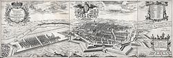
151:City map showing the town as of 1688
94:. Construction started in 1650. The
14:
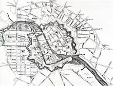
188:A map of Berlin in 1710: The new
321:II. „Wittgensteinsches“ Bollwerk
40:
136:ordered the engineer architect
218:Frederick William I of Prussia
1:
122:) and Köpenick in the east (
416:17th-century fortifications
34:Near Berlin in Germany
437:
192:appears in the lower left.
354:XIII. Lustgarten-Bollwerk
181:, also runs through it.
39:
32:
23:
339:VIII. Stralauer Bollwerk
193:
152:
138:Johann Gregor Memhardt
244:between the stations
187:
150:
348:XI. Dragoner-Bastion
102:of the 17th-century
222:Berlin Customs Wall
98:, walls, moats and
307:Neustädtisches Tor
194:
153:
406:History of Berlin
128:Thirty Years' War
84:
83:
428:
373:
246:Hackescher Markt
238:Berlin Stadtbahn
178:Unter den Linden
161:Friedrichswerder
44:
35:
16:
436:
435:
431:
430:
429:
427:
426:
425:
386:
385:
367:
361:
310:
305:New Town Gate (
290:
271:Köpenick Gate (
258:
250:Jannowitzbrücke
230:Hausvogteiplatz
173:Sophie Dorothea
124:Köpenick Palace
120:Spandau Citadel
112:
88:Berlin Fortress
33:
28:
19:Berlin Fortress
12:
11:
5:
434:
432:
424:
423:
418:
413:
408:
403:
398:
388:
387:
384:
383:
360:
357:
356:
355:
352:
349:
346:
343:
340:
337:
334:
331:
328:
325:
322:
319:
316:
313:Dorotheenstadt
303:
298:Spandau Gate (
296:
285:Georges Gate (
283:
276:
273:Köpenicker Tor
269:
264:Leipzig Gate (
257:
256:Fortifications
254:
202:Friedrichstadt
190:Friedrichstadt
165:Dorotheenstadt
116:Bundesstraße 1
111:
108:
82:
81:
78:
74:
73:
70:
66:
65:
62:
58:
57:
53:
52:
50:
46:
45:
37:
36:
30:
29:
26:Festung Berlin
24:
21:
20:
13:
10:
9:
6:
4:
3:
2:
433:
422:
419:
417:
414:
412:
409:
407:
404:
402:
399:
397:
394:
393:
391:
381:
380:3-931121-26-7
377:
371:
366:
363:
362:
358:
353:
350:
347:
344:
341:
338:
335:
332:
329:
326:
323:
320:
317:
314:
308:
304:
301:
300:Spandauer Tor
297:
294:
288:
284:
281:
277:
274:
270:
267:
266:Leipziger Tor
263:
262:
261:
255:
253:
251:
247:
243:
239:
235:
231:
226:
223:
219:
214:
211:
207:
203:
199:
191:
186:
182:
180:
179:
174:
170:
167:(marked with
166:
162:
157:
149:
145:
143:
142:bastion forts
139:
135:
131:
129:
125:
121:
117:
109:
107:
105:
101:
97:
93:
89:
79:
75:
71:
67:
63:
59:
54:
51:
47:
43:
38:
31:
27:
22:
17:
306:
299:
292:
286:
279:
278:Mills Gate (
272:
265:
259:
227:
215:
209:
205:
195:
176:
168:
158:
154:
132:
113:
104:bastion fort
87:
85:
56:Site history
25:
368: [
365:Peter Feist
198:Frederick I
69:In use
49:Coordinates
390:Categories
359:Literature
287:Georgentor
159:While the
80:Demolished
295:) in 1701
293:Königstor
280:Mühlentor
72:1650-1740
96:ramparts
234:bastion
110:History
378:
100:glacis
92:Berlin
411:Walls
372:]
242:Mitte
61:Built
376:ISBN
248:and
208:and
86:The
77:Fate
64:1650
289:),
392::
370:de
309:)
302:)
282:)
275:)
268:)
210:D
206:C
169:E
Text is available under the Creative Commons Attribution-ShareAlike License. Additional terms may apply.